BajaNomad

San Juanico and back

bajachris - 8-30-2013 at 11:21 AM

We just returned from Scorpion Bay. Went in the north road and out the south road. It was 21 miles paved to San Ignacio and 10 fairly good unpaved (as of 7 weeks ago) We made the big mistake of trying salt flats on high tide. Locals said it was impassible. We ended up on the mountain road. Talk about pure hell on a road. Lots of deep sand where you had to put truck in four wheel drive. Lots of rocks. Broke our trailer hitch and had to unload quad and ride it 30 miles into San Juanico. I would never recommend the north mountain road. However I wish we had stopped at San Jose de Gracia. Supposed to be full of mango trees and all kinds of fruit trees.

South road was wonderful. The roads were perfect, or they were working on them.

woody with a view - 8-30-2013 at 12:26 PM

welcome to the Once and Done, Upper Road Club!

Ateo - 8-30-2013 at 12:38 PM

Yep Woody, I've done that road once, and I will never do it again.

Thanks for the road report bajachris! I lost my front cow bumper on that road in '94. It flew over the top of my Isuzu Rodeo on a bump on the North Road.

BajaGeoff - 8-30-2013 at 12:55 PM

Bummer that the salt flats were not an option. I did the salt flats a few years back heading into San Juanico to work a pit for NORRA. 2WD....heavy trailer...and it was at night. Piece of cake. The inland upper road is terrible!

Sunman - 8-30-2013 at 02:08 PM

SdG is a wonderful oasis...full of wonderful people. Spent the night at the Junta once, truly a great experience.

BajaBlanca - 8-30-2013 at 04:05 PM

Upper road is a nightmare. Welcome to the club!

Mulegena - 8-30-2013 at 04:11 PM

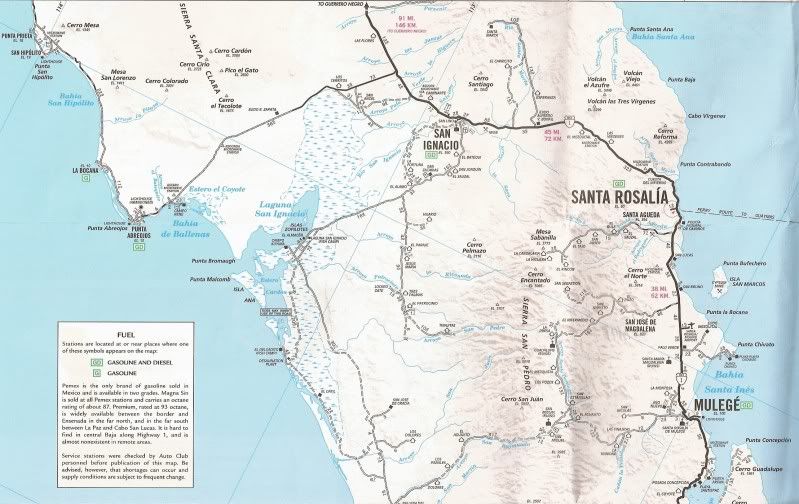
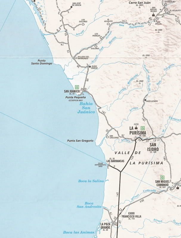
Can we get a witness, errr, I mean a map of the two roads?

edited to say, it's not that I don't like you guys but I just don't want to join this particular Baja club if I my Toyota can possibly help it.

[Edited on 8-30-2013 by Mulegena]

David K - 8-30-2013 at 04:26 PM

Quote:
Originally posted by Mulegena
Can we get a witness, errr, I mean a map of the two roads?

edited to say, it's not that I don't like you guys but I just don't want to join this particular Baja club if I my Toyota can possibly help it.

[Edited on 8-30-2013 by Mulegena]


Let's see if this helps:

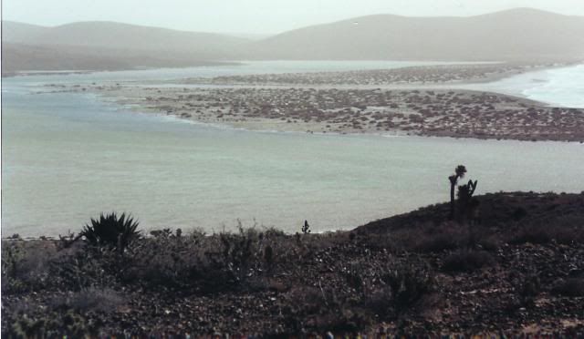
High view, just north of San Jaunico:


NORTH HALF:


SOUTH HALF:


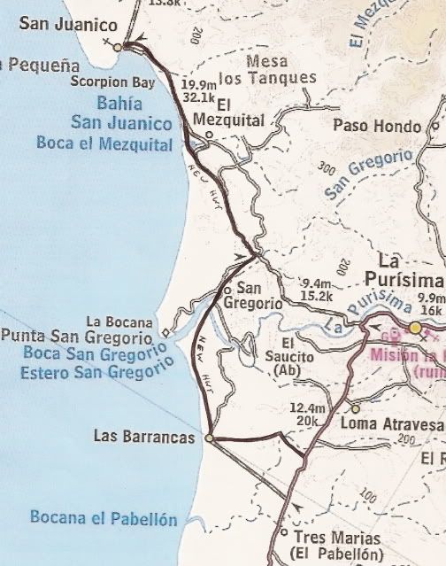
New Paved Road south of San Juanico to Las Barrancas:

Mulegena - 8-30-2013 at 04:57 PM

Thought you might show up, David K, thanks.

So to clarify, going north from San Juanico we pass Cadeje and La Ballenas and bear west and hope the tide let's us pass. Both roads, the more easterly mountain road and the westerly track through the salt flats lead directly to Campo La Kuyima, correcto?

David K - 8-30-2013 at 05:03 PM

Quote:
Originally posted by Mulegena
Thought you might show up, David K, thanks.

So to clarify, going north from San Juanico we pass Cadeje and La Ballenas and bear west and hope the tide let's us pass. Both roads, the more easterly mountain road and the westerly track through the salt flats lead directly to Campo La Kuyima, correcto?


Yes... the inland road passes the driveway for San Jose de Garcia and the salt flat road goes past El Datil.

There is even a 'more mountain' road than shown on the AAA map going south from El Patrocinio... and also a SCORE route from that higher road to Rancho Cuarenta (not shown on map, but at the arroyo crossing next to Mile 30.7 on the map).

The third map showing the new paved road was sketched from the government billboard map and not exactly where they paved the road, but close. See the route on Google Earth.

[Edited on 8-31-2013 by David K]

TMW - 8-31-2013 at 11:40 AM

I love both roads. The worse the better. What's that saying. " Bad road good people, Good road bad people".

Skipjack Joe - 8-31-2013 at 12:10 PM

The Ugly People?

They get the bad road too.

Bajaahh - 8-31-2013 at 12:18 PM

So I have always been under the impression that the salt flats are more questionable after rain, not tides.
Ive been though them twice now and Im trying to figure out how the water could come up that far to flood the path though them. I think if the tide flooded them every day then they would never be crossable, whereas after a good rain they need some time to "dry out" before becoming crossable.
Are there TWO roads through the salt flats or have I been lucky enough not to have to deal with extreme tides?

TMW - 8-31-2013 at 07:54 PM

Basically there is only one road thru the salt flats. Maybe I've been lucky but I've never been thru when there was much water on it. Usually if there is water you skirt the edge for higher ground so I think you maybe right as to rain. But I've heard others talk about the high tides so maybe it's only on a full moon type thing.

Bajaahh - 8-31-2013 at 08:11 PM

Quote:
Originally posted by TW
Basically there is only one road thru the salt flats. Maybe I've been lucky but I've never been thru when there was much water on it. Usually if there is water you skirt the edge for higher ground so I think you maybe right as to rain. But I've heard others talk about the high tides so maybe it's only on a full moon type thing.

woody with a view - 8-31-2013 at 08:36 PM

THAT IS THE BEAUTY OF THE NORTH ROAD....it keeps the riff raff out!:P

MMc - 8-31-2013 at 08:42 PM

Nothing can keep the riff raff out. Kinda surprise DK has not been there:lol::lol::lol:

woody with a view - 8-31-2013 at 08:49 PM

^^^what he said^^^

:lol::lol::lol::lol::lol::lol:

Desertbull - 9-1-2013 at 08:42 AM

The high road is hardly traveled by any but newbies who get lost...no one in their right mind would want to travel the high road especially after a storm, it has lots of washouts and go arounds and it beats you and your vehicle to smithereens!

The sand highway is another road, if you don't know what it is then I highly suggest not to go. I've found many A lost, stuck and buried in the deep sand, stranded and unprepared Americans on this trail. Unless you have 4WD and / or you know how to drive in the sand don't venture this way. Yes I know plenty of regulars who go this way in 2WD but they are experienced and know how to drive in the deep sand....this is a route to follow a friend and prepare for the worst.

The Salt Flats are an eloborate maze of combined trails and roads that are fast and quick and the route changes with the tide, sometimes daily and sometimes not for 6 months at a time. If the tide is high and depending how high, it may be impassable and you need to go around via the Sand Highway, but we use a bunch of other trails as well. When the tide is high you DON'T want to get stuck in the Salt Flats mud...

On the other hand you can travel at 55 mph on the flat hard Salt Flats and its smoother than the freeway...

:lol::lol::lol::lol:

Mexitron - 9-1-2013 at 02:21 PM

If you've ever seen the salt flat below Punta Blanca its usually a racetrack but here it is in winter with high surf and high tides...a lot of rain might do this but it would take a lot.


woody with a view - 9-1-2013 at 02:41 PM

^^^That's scary^^^

Sweetwater - 9-1-2013 at 05:44 PM

Having done both roads on motos, the journey was intentional both times, I would recommend the salt flats to the high road if at all possible. I can't think of circumstances that would send me on the high road again. The entire area is one of the scenic wonders of the Pacific side of Baja, IMHO. I can't wait to go back again, especially if it's a DK free area.....:P

MMc - 9-1-2013 at 06:10 PM

When he does go. We will read ALL ABOUT IT, for years:lol: maps and way points to follow.

David K - 9-1-2013 at 06:27 PM

Interesting... some of us are givers and others just take...

woody with a view - 9-1-2013 at 06:34 PM

:barf:

MMc - 9-1-2013 at 06:44 PM

Some of us know difference between giving and spewing.