BajaNomad

2013 Baja 1000 Access Roads

TMW - 10-7-2013 at 11:02 AM

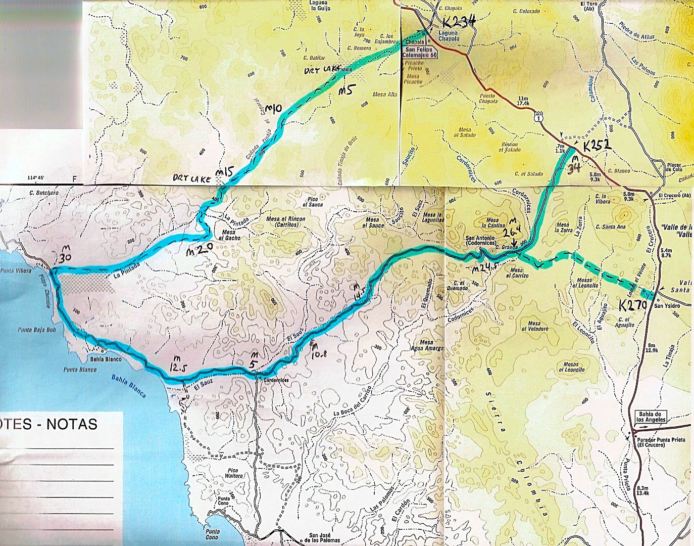
Using a AAA map of the lower part of the Baja 1000 course I've marked some access roads for those that will be chasing, pitting or just watching. Remember on race day DO NOT go backwards on the race course. It's best to stay off the race course if at all possible. I've also provided two of my trip post that have more details of these access routes.

Blue is the Race Course and Green is the Access Roads.


South of San Quintin there are two access that join together KM16 and KM24. Meets the race course in about 30 miles from the Hwy depending on the actual route the race takes.

Below El Rosario at KM103 is the R. Los Martires access. There is a rancho at the turn off. The access road joins the race course near the El Sauzalito mining area.

At KM133 a road to the Pacific is marked Puerto Santa Catarina. About 14 miles down the road is Rancho Santa Catarina. Near the fish camp of Puerto Canoas the road turns northeast at a jct and in about 15 miles joins the race course.

At KM149 is the El Marmol Onyx mine turn off. It meets the race copurse about half way to the digs.

The race course will cross hwy 1 at KM 168. A hwy sign may say Faro San Jose or something similar.

At KM233 is the Laguna Chapala turn off for Cocos Corner and the race course. Also a road to the west and the Pacific Coast is there. It meets the race course about 10 miles north of Punta Blanca.

KM251 east side of Hwy 1 is access to the race course about 9 miles north of El Crucero.

KM252 is a road on the west side of Hwy 1 that access the race course about 5 miles in. Look for a white house on the north side set back on a hill and the race course is very near.

KM261 is El Crucero, sorry I didn't mark it on the map, but you can't miss it.

KM271 is where the race course crosses Hwy 1.

Access from the south is at Santa Rosalillita. The Hwy turn off is KM38. The road north is just east of the airstrip before the town.

A couple of other notes.

1-The race course from the ocean to Hwy 1 at KM168 can be very slick mud if it rains. It's like driving on grease, not deep just slick. Be carefull.

2-Both the race course and the access road at KM233 will have silt beds, some pretty bad, as you get near the ocean. Pick your line carefully.

2009 Trip Ocean Loop.
http://forums.bajanomad.com/viewthread.php?tid=39975&pag...

New Years 2013 trip Out of San Quintin.
http://forums.bajanomad.com/viewthread.php?tid=64875

[Edited on 10-7-2013 by TW]

motoged - 10-7-2013 at 08:16 PM

TW,
I passed this along to a buddy who is support to one of the moto teams from Kamloops.....he said it helped solved a locating problem....so thanks from a few locals :coolup:

David K - 10-7-2013 at 10:14 PM

Great work TW!

Ateo - 10-8-2013 at 07:39 AM

Yeah. Dig it TW. Thanks.

bajabuddha - 10-8-2013 at 09:14 AM

Great info except for one thing (for us non-motorheads)... WHEN is the event? Chase rigs w/young inexperienced drivers with big gear trailers and little sleep plus racers 'warming up' on Hwy 1 are a bit of a hazard too. Good to stay clear then too.

David K - 10-8-2013 at 09:15 AM

See the thread: http://forums.bajanomad.com/viewthread.php?tid=68481

Race Days Nov. 14-15, 2013

Pacifico - 10-8-2013 at 09:32 AM

Quote:
Originally posted by David K
See the thread: http://forums.bajanomad.com/viewthread.php?tid=68481

Race Days Nov. 14-15, 2013


Bikes start at 11 pm on the 14th. Cars start on the 15th....

Main race days are 15-16.

Be careful out there!

TMW - 10-9-2013 at 11:13 AM

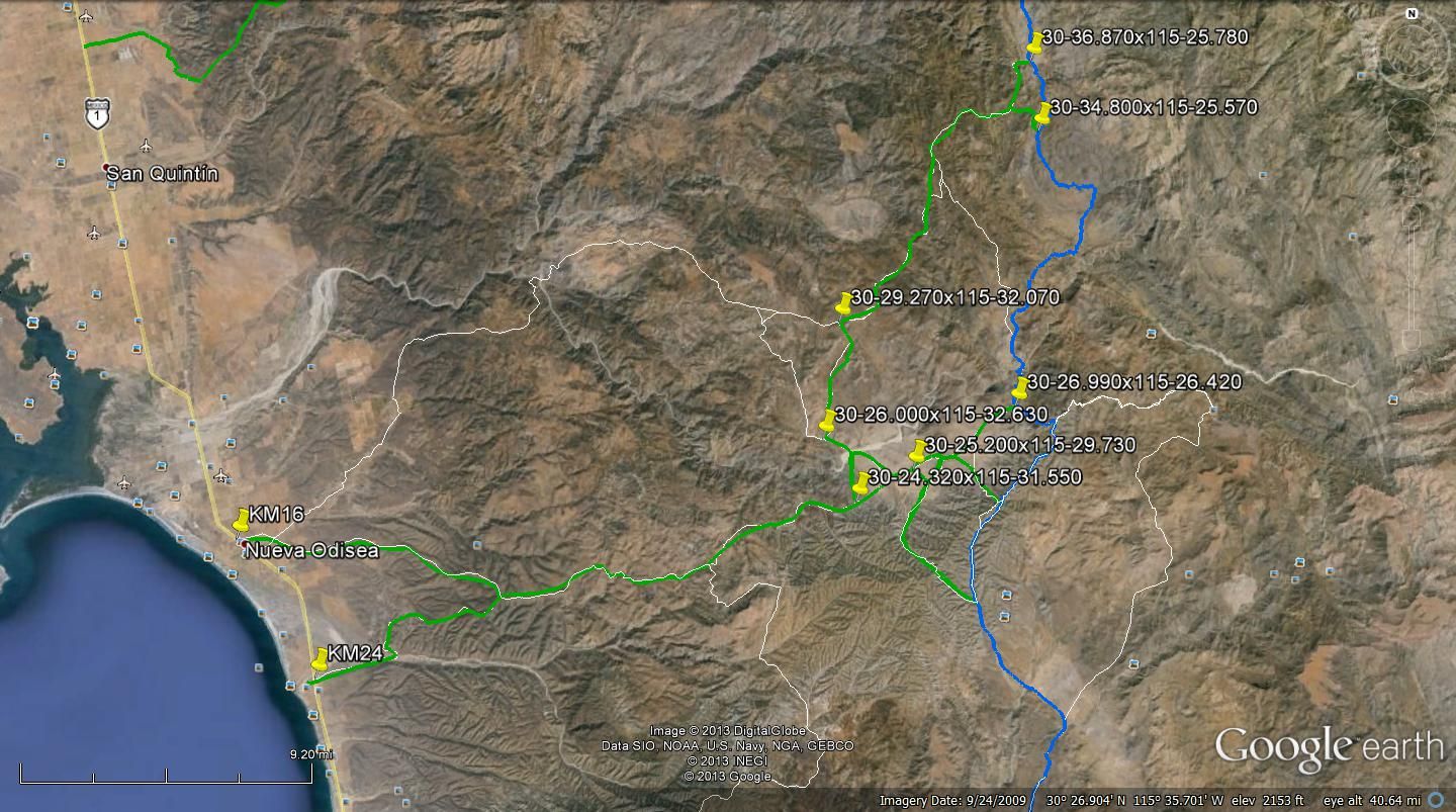
It appears that the 2013 B1K will use a similar route from near the Sauzalito mine area north of Hwy1 at km103. Below are two google earth maps with the 2003 B1K course in blue. I've added access roads in green and show other roads in white.

The first picture expands on the AAA map above I added GPS coordinates.
Note the top white line at KM16. I would not recommend using it as the first few miles get very confusing due to many roads going everywhich way.


This second picture shows an access road to the course. I followed the road that google earth showed coming from Hwy1. There are others but I could not tell if they were thru roads. The turn off from Hwy1 is approx. 4.7 miles north of the bridge. The bridge is south of a cluster of hotels the La Villa de San Quintin hotel is easy to see. At 3.3 miles further north is another access road.


From the SCORE map it looks like the race course will jump on the Hwy near the bridge at Vicente Guerrero. This is just south of the turnoff for Mission Santo Domingo, there is a sign showing it.

[Edited on 10-10-2013 by TW]

Race camping

dpwahoo - 10-24-2013 at 09:32 AM

Quote:
Originally posted by TW
Using a AAA map of the lower part of the Baja 1000 course I've marked some access roads for those that will be chasing, pitting or just watching. Remember on race day DO NOT go backwards on the race course. It's best to stay off the race course if at all possible. I've also provided two of my trip post that have more details of these access routes.

Blue is the Race Course and Green is the Access Roads.


South of San Quintin there are two access that join together KM16 and KM24. Meets the race course in about 30 miles from the Hwy depending on the actual route the race takes.

Below El Rosario at KM103 is the R. Los Martires access. There is a rancho at the turn off. The access road joins the race course near the El Sauzalito mining area.

At KM133 a road to the Pacific is marked Puerto Santa Catarina. About 14 miles down the road is Rancho Santa Catarina. Near the fish camp of Puerto Canoas the road turns northeast at a jct and in about 15 miles joins the race course.

At KM149 is the El Marmol Onyx mine turn off. It meets the race copurse about half way to the digs.

The race course will cross hwy 1 at KM 168. A hwy sign may say Faro San Jose or something similar.

At KM233 is the Laguna Chapala turn off for Cocos Corner and the race course. Also a road to the west and the Pacific Coast is there. It meets the race course about 10 miles north of Punta Blanca.

KM251 east side of Hwy 1 is access to the race course about 9 miles north of El Crucero.

KM252 is a road on the west side of Hwy 1 that access the race course about 5 miles in. Look for a white house on the north side set back on a hill and the race course is very near.

KM261 is El Crucero, sorry I didn't mark it on the map, but you can't miss it.

KM271 is where the race course crosses Hwy 1.

Access from the south is at Santa Rosalillita. The Hwy turn off is KM38. The road north is just east of the airstrip before the town.

A couple of other notes.

1-The race course from the ocean to Hwy 1 at KM168 can be very slick mud if it rains. It's like driving on grease, not deep just slick. Be carefull.

2-Both the race course and the access road at KM233 will have silt beds, some pretty bad, as you get near the ocean. Pick your line carefully.

2009 Trip Ocean Loop.
http://forums.bajanomad.com/viewthread.php?tid=39975&pag...

New Years 2013 trip Out of San Quintin.
http://forums.bajanomad.com/viewthread.php?tid=64875
Tw, We plan to go from la Mision a day early, as our trip to Ojos Negros did not work out well for the 500. We wplan to go aa day early to get set. we hope it to be safe and most of all end up in the right place for proper viewing. i assume it will be les crowded down there than ensenada, fo instance, ojos negros. Thank you, TW, we will try to use the map, and go early, to avoid confusion. Any responce would be appreciated. Dennis
[Edited on 10-7-2013 by TW]

woody with a view - 10-24-2013 at 11:31 AM

Quote:
Originally posted by Pacifico
Quote:
Originally posted by David K
See the thread: http://forums.bajanomad.com/viewthread.php?tid=68481

Race Days Nov. 14-15, 2013


Bikes start at 11 pm on the 14th. Cars start on the 15th....

Main race days are 15-16.
Be careful out there!


i WAS planning on a 1pm start on the 15th heading south and trying to make El Rosario for the night, continuing south the next morning. the backup plan was to run early saturday morning and drive straight thru to the central surf zone. looks like this is gonna present a pro'lem.....

anyone hazard a guess what the hiway delays will be like either day?:?::?:

mtgoat666 - 10-24-2013 at 11:57 AM

Quote:
Originally posted by woody with a view
Quote:
Originally posted by Pacifico
Quote:
Originally posted by David K
See the thread: http://forums.bajanomad.com/viewthread.php?tid=68481

Race Days Nov. 14-15, 2013


Bikes start at 11 pm on the 14th. Cars start on the 15th....

Main race days are 15-16.
Be careful out there!


i WAS planning on a 1pm start on the 15th heading south and trying to make El Rosario for the night, continuing south the next morning. the backup plan was to run early saturday morning and drive straight thru to the central surf zone. looks like this is gonna present a pro'lem.....

anyone hazard a guess what the hiway delays will be like either day?:?::?:


dunno 'bout hwy delays, but i have experienced hwy 1 around race days, and you will meet lots of gringos (and mexicans) down for the race who think hwy 1 is exempt from traffic laws and rules of common courtesy. Some (many?) of the race fans and support crews are the worst sorts of jerk drivers (tail gating, driving too fast, passing like jerks), i just avoid those days all together.

woody with a view - 10-24-2013 at 08:12 PM

we can't avoid it. days are cemented in stone. gonna run the gauntlet.

btw, how is getting thru Ensenada on race daze? where is the starting line? i hope it's 5 miles east of the harbor!

rts551 - 10-24-2013 at 09:00 PM

woody, you are in for trouble. Ensenada will be a mess. Bay road will take 2-3 hours to get through on race day with all the detours etc. best to go around.
El roaslrio/catavina/and probably Sanquintin will all be full. Hiways will be raceways. good luck

woody with a view - 10-25-2013 at 04:23 AM

by go around, do you mean take the road north around town to the hiway instead of going along the bay?

David K - 10-25-2013 at 06:27 AM

I think he means Hwy. 5? Like go WAY around... that is the race course however... some of the way!

woody with a view - 10-25-2013 at 07:39 AM

my trailer won't make it back thru to chapala. i guess i'll just enjoy the misery that is race day!

Ateo - 10-25-2013 at 08:08 AM

Woody, do not take the bayfront road thru Ensenada if you're coming thru raceday.. The race starts on this road. Take the left turnoff before heading into town and bypass the mess.

MMc - 10-25-2013 at 10:40 AM

Woody, The back way will suck also, but it will be passable. Any good map will get through it. Yes, The north is correct, same as the truckers use. Try to get through town before daylight.

woody with a view - 10-25-2013 at 11:20 AM

how about friday 4pm passing thru?

Ateo - 10-25-2013 at 01:14 PM

That should be a better time Woody. No racing will be going on in Ensenada at 4pm. Have a fun trip. I may see you down there in the road.

woody with a view - 10-25-2013 at 04:24 PM

let me know before you split and maybe we can swap lies and propaganda on the road to nowhere....

Ateo - 10-25-2013 at 04:26 PM

10-4

TMW - 10-26-2013 at 10:17 AM

Just got back from spending about a week in Baja. Road construction with detours in the dirt at KM103 south of Ensenada for a few miles but traffic is moving good. More road work further north several miles but I don't remember the KM mark. Traffic was moving good thru it. Race vehicles are on the highway at Camalu for about 15 miles and one more very short on/off section about 10 miles further north. North of Catavina they cross the highway at KM168. The southern most hwy crossing is at KM170/171 north of the LA Bay turnoff. If you use a 55mph average for the faster racers you can pretty much time where the lead vehicles will be with a whole lot of slower ones following.

bajaandy - 10-26-2013 at 10:34 AM

Woody, try to go thru (AROUND) Ensenada on contingency day, which is Thursday the 14th. If you can do that, you'd be well ahead of the race day hoopla. You'll still have to deal with the chasers and pit crews heading south that night, but it shouldn't be too bad. If I make it down there, I'll keep my eyes peeled for you.
Catch one for Curt.

woody with a view - 10-26-2013 at 10:48 AM

i can't leave til 1pm-ish on friday.

and i will Catch one for Curt!

[Edited on 10-26-2013 by woody with a view]

liknbaja127 - 10-26-2013 at 07:47 PM

woody, late is better, in Enesnada on race day, but hwy 1 will be filled
with chase trucks, and race people! if you must drive, at this tme, be safe!
be carefull!

woody with a view - 10-27-2013 at 07:34 AM

sounds like it's gonna be brutal. i got 3 weeks to get my mind right!

StuckSucks - 11-18-2013 at 03:50 PM

I worked as a recovery vehicle for our Class 10 car near race mile 433 (Punta Blanca). The road in from KM233 is impressive - definitely 4x4. It's silty and rocky and a slow go - the road is 35 miles long and took us three hours to get to the Pacific. The keyword is REMOTE. As it turned out, our Trophy Truck and Class 10 both DNF'd prior to getting to us.

We got to help two motorcycles and one car - we think they stopped because we were the only humans for miles.

On Saturday morning we drove out, stopped at Coco's for a cerveza, then Alfonsina's for dinner and a room.

Photos and videos to follow.

[Edited on 11-18-2013 by StuckSucks]

[Edited on 11-18-2013 by StuckSucks]

Ateo - 11-18-2013 at 04:02 PM

Quote:
Originally posted by StuckSucks
I worked as a recovery vehicle for our Class 10 car near race mile 433 (Punta Blanca). The road in from KM233 is impressive - definitely 4x4. It's silty and rocky and a slow go - the road is 35 miles long and took us three hours to get to the Pacific. They keyword is REMOTE. As it turned out, our Trophy Truck and Class 10 both DNF'd prior to getting to us.

We got to help two motorcycles and one car - we think they stopped because we were the only humans for miles.

On Saturday morning we drove out, stopped at Coco's for a cerveza, then Alfonsina's for dinner and a room.

Photos and videos to follow.

[Edited on 11-18-2013 by StuckSucks]


Cool. Can't wait to see some videos and photos.

StuckSucks - 11-19-2013 at 06:22 PM

We took a dirt road from Laguna Chapala KM233, west to Punta Blanca. Working for COPS Racing, our job was to hang out in the silt beds near RM430, and extract our race cars, should one get stuck (this applies for the Class 10, not the Trophy Truck). The road was 35 miles to the coast and took three hours. Expect rocks and silt, some bad, some not so bad - not for 2x4. At first I was indignant that BFG didn't include this route in their pit books, but quickly figured out why they didn't.

Crossing a dry lake bed about 5 miles west of Chapala:


Down a hill about 10 miles from the highway. A short distance farther, we passed a Mag 7 pit trailer on the side of the road, bent in half. As it turned out, the worse was yet to come.


The road meanders toward the coast:


Mid afternoon, we were passed by dirt bikes and quads in the race:


Camp site next to VCP41. The race came at us from the right, made a square right corner (where the quad headlight is), and headed north along the coast.


Driving back to Chapala on Saturday morning. The desert was green and blooming and happy.


The road had heavy rutting almost everywhere. In one place, the road had 6' deep ruts (we figured a way around).


Bonus photos from Coco's Corner:


David K - 11-19-2013 at 06:30 PM

Great! Thank you!!

Ateo - 11-19-2013 at 06:35 PM

Great license plate. I could've sworn I saw you at the Pemex in El Rosario on Thursday around 1PM. Nice photos. Thanks for taking the time.

StuckSucks - 11-19-2013 at 06:41 PM

Quote:
Originally posted by Ateo
Great license plate. I could've sworn I saw you at the Pemex in El Rosario on Thursday around 1PM. Nice photos. Thanks for taking the time.


That was probably me - I was gassing up at Rosario about then. We spent the night with the rest of the team where the course crosses the highway north of Catavina, then drove into Punta Blanca Friday morning.

As far as we can tell, we were the only humans for miles next to the course on the coast - we ended up helping three different teams other than ours. I think they were happy to see anyone. And good karma for us.

David K - 11-19-2013 at 06:52 PM

Quote:
Originally posted by StuckSucks
Quote:
Originally posted by Ateo
Great license plate. I could've sworn I saw you at the Pemex in El Rosario on Thursday around 1PM. Nice photos. Thanks for taking the time.


That was probably me - I was gassing up at Rosario about then. We spent the night with the rest of the team where the course crosses the highway north of Catavina, then drove into Punta Blanca Friday morning.

As far as we can tell, we were the only humans for miles next to the course on the coast - we ended up helping three different teams other than ours. I think they were happy to see anyone. And good karma for us.


:lol:

That's easy to explain... the surf N-zis have made it clear that area of the world doesn't exist! Also, no matter how many maps and guides have shown the road, unless it is graded or paved don't expect to see many others in that part of Baja. Heck, even the graded roads aren't traveled much!

Thanks for the photos... nice that the dry lake west of Chapala (El Islote) was dry... You can see it covered with water on some satellite images from the past. We even discussed it as a 'Lost Lake' a few years ago... before the road west from Chapala was made.

Thanks again!

StuckSucks - 11-19-2013 at 08:42 PM

Quote:
Originally posted by David K
Thanks for the photos... nice that the dry lake west of Chapala (El Islote) was dry... You can see it covered with water on some satellite images from the past. We even discussed it as a 'Lost Lake' a few years ago... before the road west from Chapala was made.

Thanks again!


Thanks for the name - I was wondering what that lake was called. And while I doing my homework to get out there with Google Maps, I saw the lake was flooded and slightly panicked. But then I noticed that the imagery was from '08.

El Islote was a handsome playa.


[Edited on 11-20-2013 by StuckSucks]

motoged - 11-19-2013 at 11:54 PM

I look at dry lake beds like that and think...."Oh boy....let's rip!" .... and then am reminded of times "dry" turns to goo in a heartbeat :o

What are the telltale signs that the dry crust is only a few inches deep and underneath that is a ton of hurt?


A few years back a friend pre-running the 1000 on a moto took a brief "shortcut" to straighten out a curve in the track on Laguna Salada....took five guys four hours to get him out :O

TW's Road Log

David K - 11-20-2013 at 10:18 AM

TW made mileage notes going to the coast from Chapala and then coming back out on the older road via San Antonio...

The map route I made using Google Earth, since the Chapala to Pacific road is not on the Almanac.


The Dry Lake was Mile 5 and another at Mile 15.
The coast road was Mile 30.
It was 12.5 miles south on the coast road to the San Antonio road.
Leave the coast road, reset odometer to 0.
San Antonio was Mile 24.5.
The fork to go either to Hwy. 1 north (Km. 252) at Mile 34, or Hwy. 1 south (Km. 270) was at Mile 26.4

StuckSucks - 11-20-2013 at 03:43 PM

Quote:
Originally posted by David K
TW made mileage notes going to the coast from Chapala and then coming back out on the older road via San Antonio...


The San Antonio part was this year's race course, so I couldn't use it for access. Chapala was my only option.

StuckSucks - 11-20-2013 at 03:50 PM

Quote:
Originally posted by David K
The Dry Lake was Mile 5 and another at Mile 15.


The lake at M15 was in a wide valley covered with grass - the actual lake was a little north of the road, so it doesn't jump out at you.

David K - 11-20-2013 at 04:15 PM

10-4, thanks... I think it was the 2003 Baja 1000 (Dust to Glory year) that it was originally going to come to Chapala from the coast on the new (dry lake) road... but at the drivers request, due to dust pits 'of the 3rd Kind', the race course came back up the Faro San José road to Santa Ynez/ Cataviña then ran the highway to Chapala.