BajaNomad

Baja Nov3-9

spikemd - 10-7-2013 at 11:44 AM

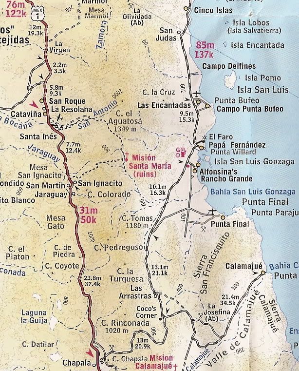
I am heading to Baja Nov 3rd-9th for a week of exploring, fishing and relaxing. I will be heading down 5 to Punto Buffeo north of Gonzaga Bay to meet up with a family friend who has a fishing cabin. We will either stay there for a few days or right on Gonzaga Bay. I want to explore some of the trails in the area and definitely visit Coco's Corner. We may head further south to BOLA for a day or two.

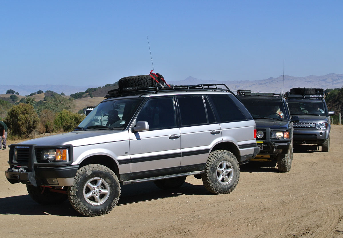
I have the Baja Almanac and have been studying all the roads and trails in the area. I will be driving a 2001 Range Rover modified with lift, 33inch tires, winch and armor. I am hoping a few other rovers will be joining me, but scheduling has been a challenge.

Any roads/trails that I should definitely see? Any I should definitely avoid? Thanks.

my truck:


[Edited on 10-7-2013 by BajaNomad]

TMW - 10-7-2013 at 12:01 PM

Go south and have a cold one with Coco. There is a turquesa mine and water pools a little north of Cocos worth looking and exploring. South east of Coco is the ruins of Mission Calamajue and an abondoned gold mine. Also the AB mine El Pozo de Lacy and grave near Punta Final.

TMW - 10-7-2013 at 12:03 PM

Here is a loop to the Pacific Ocean you can do. Take a pole and catch a fish.

http://forums.bajanomad.com/viewthread.php?tid=39975&pag...

durrelllrobert - 10-7-2013 at 12:04 PM

Quote:
Originally posted by spikemd


Any roads/trails that I should definitely avoid? Thanks.


As you pass through Ensenada be sure to avoid the trail leading to Anthony's :lol:

David K - 10-7-2013 at 02:10 PM

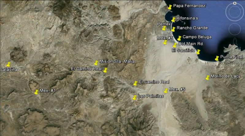
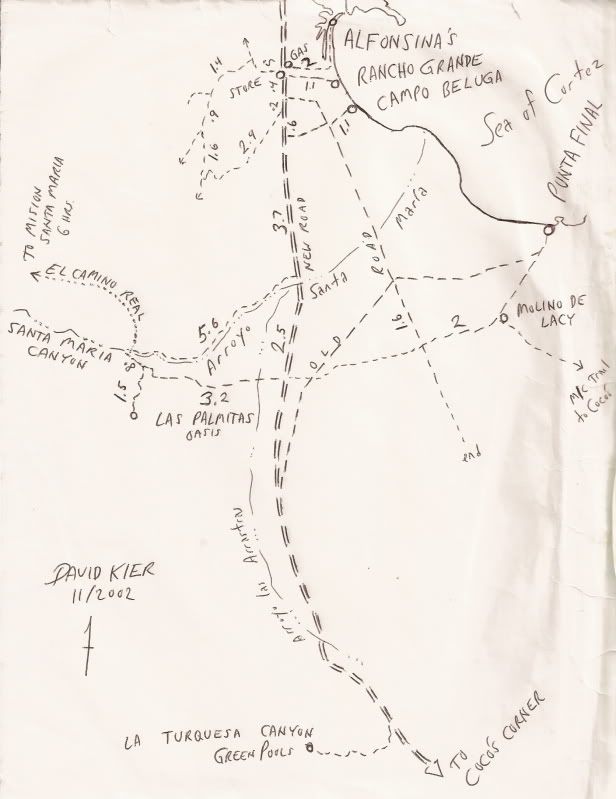
Plenty to see and do around Gonzaga Bay... I have them linked as:


Bahia San Luis Gonzaga Area

Mission-era warehouse ruins on the shore of the bay
Alfonsina's Beach
Onyx Springs create a mineral glacier
Molino de Lacy ruins & grave
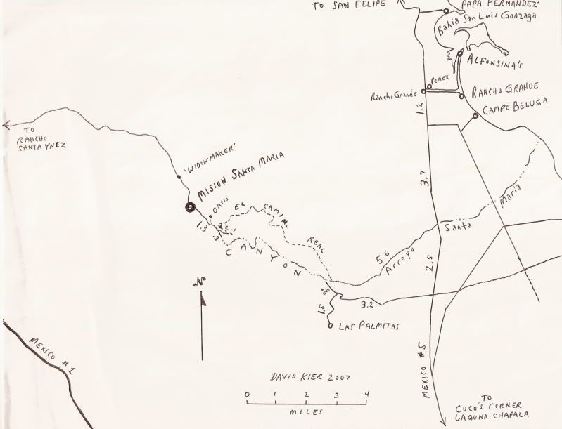
Las Palmitas oasis and Santa Maria Canyon
El Camino Real to Mision Santa Maria
Santa Maria Canyon from the air
La Turquesa Canyon
La Turquesa Grade
Calamajue mission site
Campo Beluga (Gonzaga Bay)
Coco's Corner 11-06
Alfonsina's 11-06
more Coco's Corner


On this page: http://vivabaja.com/tours

The Camino Real from Loreto to San Diego and beyond passes right by Coco's Corner, crosses Arroyo Santa Maria (just west of Punta Final/ Gonzaga), and climbs up to Mission Santa Maria (no, you can't drive that part, sorry).

As TW stated, you can drive to the first site for that mission, called Calamajué (Cala-ma-way) by going east at Coco's Corner, then south at the fork in just over 6 miles. Not much there sadly...

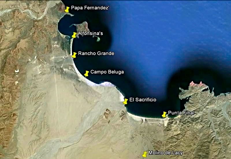
Molino de Lacy (Molino de San Francisquito before William Lacy died) is very near the Punta Final home area of 'Gonzaga Bay' (actually Ensenada de San Francisquito). Gold ore mined in the mountains to the south was milled here, then shipped out at Punta Final (originally Puerto de San Francisquito).

The Spanish mission program constructed a warehouse on the shore of Bahia San Luis Gonzaga, were caro bound for Mission San Fernando was off loaded. The outline of that warehouse from 1769 is still visible... about midway between Papa Fernandez' Resort and Alfonsina's Resort

La Turquesa Canyon's green pools and turquoise mine can be driven right to. Famous Land Rover (LR3) pilot Roy 'The Squarecircle' with help from TW and others may have been the first vehicle in the past 50 years to reach the La Turquesa Grade from the mine, and climb to the top and out to Hwy. 1 (near El Pedregoso)!

We have lots of photos of great Baja off road fun... Thumb through the links on my web site and shoot over any questions...

David

David K - 10-7-2013 at 02:13 PM

PS, Nomad requests photos posted to be no wider than 800 pixels... thanks! (Edit: Doug 'BajaNomad' has resized your photo since)

[Edited on 10-7-2013 by David K]

rts551 - 10-7-2013 at 02:24 PM

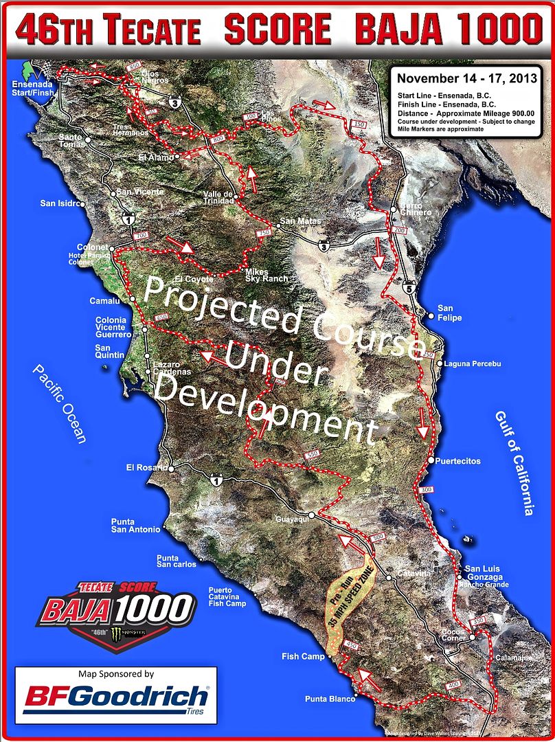
The baja 1000 is running the following weekend(14-17th). So there will be prerunners in the area of Coco Corners and North.Be careful!

David K - 10-7-2013 at 02:31 PM

Quote:
Originally posted by rts551
The baja 1000 is running the following weekend(14-17th). So there will be prerunners in the area of Coco Corners and North.Be careful!


Good point!! Pre-running is not supposed to be done at race speeds... but boys will be boys, with their 800 horsepower toys!


bajajudy - 10-7-2013 at 02:41 PM

Yea, if you start seeing day-glo tape in the trees and bushes....heads up!

bufeo - 10-7-2013 at 02:42 PM

Quote:
Originally posted by rts551
The baja 1000 is running the following weekend(14-17th). So there will be prerunners in the area of Coco Corners and North.Be careful!


True enough for the road south of Pta Bufeo. Since pavement now extends a few kilometers past that camp there shouldn't be any prerunning on the pavement.

All of those places mentioned by David K can be day trips. We've done them many times. Even went to Bahia de Los Angeles and back in a day.

Give our regards to Sra. Fernandez at PB—or any of her sons who may be in residence (Miguel, Rodrigo, Juan Pablo, Luis) although I think it's only Miguel who's there on a regular basis. We haven't been since we transferred our lease to another party, but we spent ten great years there.

Allen and Diana R.

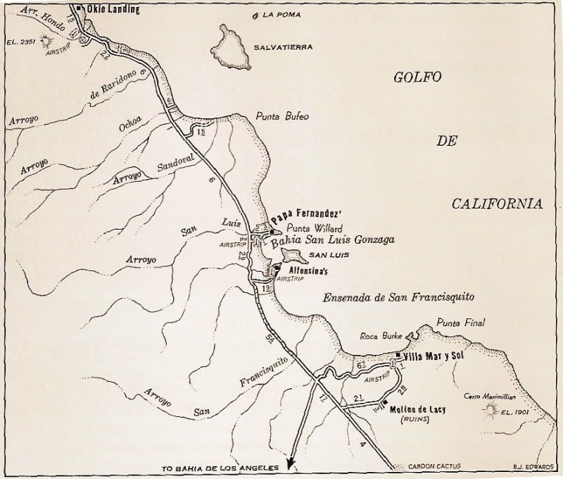
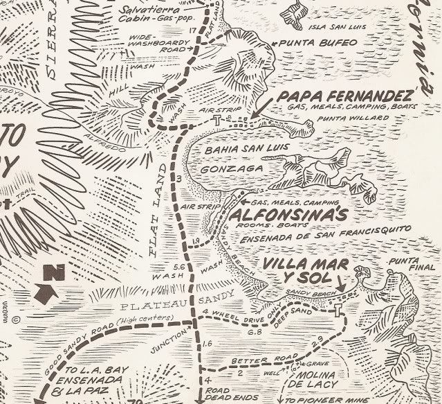
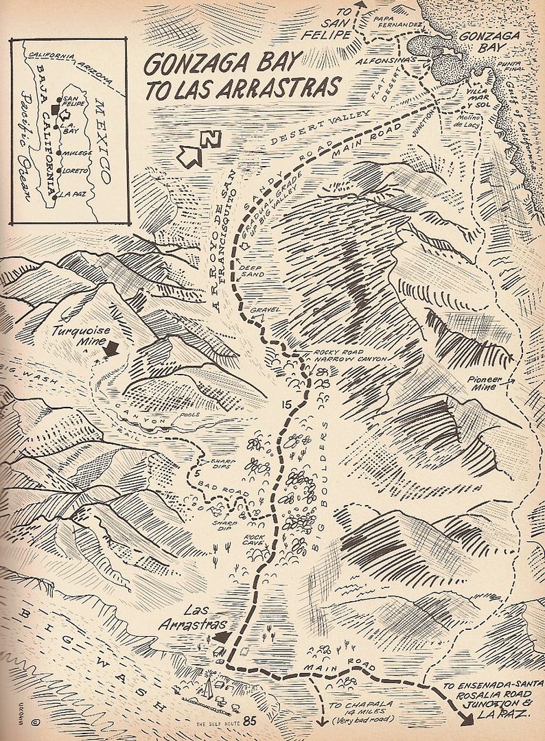
Maps

David K - 10-7-2013 at 03:46 PM


1970:


rts551 - 10-7-2013 at 03:50 PM

For some reason there are prerunners who feel the need for speed.....on the pavement and unfortunately its where many accidents happen.


Quote:
Originally posted by bufeo
Quote:
Originally posted by rts551
The baja 1000 is running the following weekend(14-17th). So there will be prerunners in the area of Coco Corners and North.Be careful!


True enough for the road south of Pta Bufeo. Since pavement now extends a few kilometers past that camp there shouldn't be any prerunning on the pavement.

All of those places mentioned by David K can be day trips. We've done them many times. Even went to Bahia de Los Angeles and back in a day.

Give our regards to Sra. Fernandez at PB—or any of her sons who may be in residence (Miguel, Rodrigo, Juan Pablo, Luis) although I think it's only Miguel who's there on a regular basis. We haven't been since we transferred our lease to another party, but we spent ten great years there.

Allen and Diana R.

spikemd - 10-8-2013 at 10:11 AM

Thanks so much for all the information. Will have to print out the maps and study them. I have the Baja Almanac which looks to be a great resource as well.

Thanks for the heads-up about the prerunners. I will be aware and careful on any of the proposed race trails.

I do plan to so some fishing near Gonzaga Bay.

Getting very excited!

(pic size noted at 800pixels. sorry.)

David K - 10-8-2013 at 05:33 PM

Quote:
Originally posted by spikemd
Thanks so much for all the information. Will have to print out the maps and study them. I have the Baja Almanac which looks to be a great resource as well.

Thanks for the heads-up about the prerunners. I will be aware and careful on any of the proposed race trails.

I do plan to so some fishing near Gonzaga Bay.

Getting very excited!

(pic size noted at 800pixels. sorry.)


Welcome to Baja Nomad! We have Baja Fever so excuse the excitement some of us have for this great place.

The Almanac is the best map that you can have, but the AAA is very handy for overall planning (has mileages on every road shown and shows gas stations etc.)...

I am a history nut, so from the 70's back to 1747, when it was discovered and named by Padre Consag, I can show you maps of Gonzaga Bay! Gonzaga Bay was also the first place I went to camp in Baja (I was 7 1/2 and totally in love with Jeepin' or 4 wheelin' and Baja ever since)!

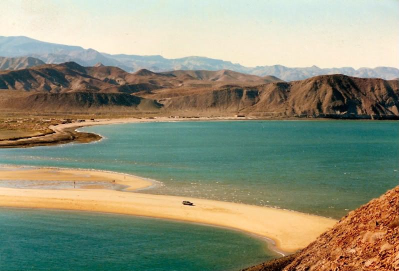
Here is Bahia San Luis Gonzaga, in 1986 or 87, at the sand spit next to Alfonsina's, where it is separated from the larger bay 'Ensenada de San Francisquito' (but everyone still calls 'Gonzaga') That's my Subaru down there and I am on a trail that goes to the top of the island in the bay:


David K - 10-18-2013 at 05:28 PM

Spike, let me know if you are seeing them okay now!