Does anyone have any info about a Turquoise Mine in the Gonzaga Bay area? Would like to take a day trip to find it.
ThanksDavid K - 11-9-2013 at 02:46 PM
Quote:
Originally posted by bajaponderosa
Does anyone have any info about a Turquoise Mine in the Gonzaga Bay area? Would like to take a day trip to find it.
Thanks
[Edited on 11-9-2013 by David K]David K - 11-9-2013 at 02:57 PM
You can also search posts for La Turquesa Canyon... there was a road that continued past the mine and goes up the mountain to Hwy. 1 (you can see the
road from the mine... Roy 'The Squarecircle' got his Land Rover across the valley and up to Hwy. 1 a few years ago with TW and others... Motorcycles
use it... call it Coco's Shortcut or Kacey Smith's XR Ride UP.bajaponderosa - 11-9-2013 at 03:02 PM
Thanks David
Sure As you know what I would get lost even with a map and a GPS.
But it would be a hell of a adventure.David K - 11-9-2013 at 03:08 PM
Quote:
Originally posted by bajaponderosa
Thanks David
Sure As you know what I would get lost even with a map and a GPS.
But it would be a hell of a adventure.
That's what is fun!
Here are the road mileages from The Gonzaga Pamex south...
Total (and partial) mileages from San Luis Gonzaga
00.0 (0.0) Rancho Grande Store, Gonzaga (across from Pemex)
01.2 (1.2) Campo Beluga and El Sacrificio road
04.9 (3.7) Arroyo Santa Maria
07.2 (2.3) Las Palmitas/Santa Maria Canyon road
09.7 (2.5) Punta Final road
14.6 (4.9) La Turquesa road
18.4 (3.8) Las Arrastras road
22.1 (3.7) Coco's Corner
34.8 (12.7) Hwy. 1, Laguna ChapalaDavid K - 11-9-2013 at 03:11 PM
Originally posted by captkw
Any photos of and mine????
[Edited on 11-9-2013 by mcfez]DavidE - 11-9-2013 at 04:48 PM
Doña Maria Espinosa's cafe has turquoise nuggets for sale and it may well be they are from this area. Pretty as can be.David K - 11-9-2013 at 05:02 PM
Thanks Deno ,... I did post the links to my two photos (from 1975) and link to the 2008 Nomad thread (which has newer photos at the mine).
My '75 Easter Break travel partner and friend from Orange Glen High School, Mike Clancy.
There are turquesa mines closer to El Rosario, near El Aguajito, where I think Mama Espinoza's samples came from. Ed at Baja's Best has some too.TMW - 11-10-2013 at 08:48 AM
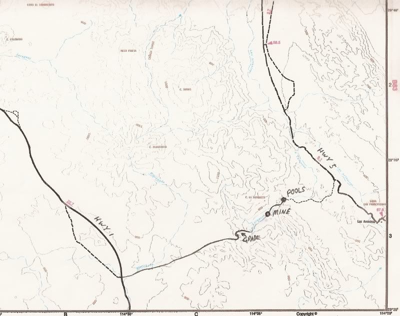
It's an interesting trip thru the arroyo from Hwy 5 to Hwy 1. Most any short wheel base 4x4 should be able to do it. Bikers do it all the time. Hwy 1
turn off is KM213/214. Here is a map from Google Earth.
[Edited on 11-10-2013 by TW]TMW - 11-10-2013 at 08:59 AM
More detail on rd out west.
David K - 11-10-2013 at 11:30 AM
That is a sweet map Tom! I can almost see Roy's tire tracks! (and your
footprints)!!!willardguy - 11-10-2013 at 11:58 AM
as far as mines go, these are duds, nothing more than small diggings in hill sides but a fine way to spend a day!David K - 11-10-2013 at 12:03 PM
To construct that road up the mountain to Hwy. 1, must have indicated enough value in the turquoise there?willardguy - 11-10-2013 at 12:09 PM
we found most of the interesting stuff is down in the stream bed.
David K - 11-10-2013 at 12:11 PM
Neat... is that an arrastra (hand operated ore mill) ruin?TMW - 11-10-2013 at 12:20 PM
I think full on mine operstions consider the product in oz per ton of ore. In Randsburg there is a gold mine operations that using the tailings. They
dump the rock then spray acid on it and extract the gold that the acid cleans from the rock. The sign says .5 oz gold per ton of rock is profitable.


 (and your
footprints)!!!
(and your
footprints)!!!