BajaNomad

Okie Landing

bynro - 12-14-2013 at 11:03 PM

I was wondering if anyone had any photos of "Okie Landing" from back when it was in operation. It was approximately 25 miles south of Puerticitos. Always been curious about those foundations there. Thanks!

David K - 12-14-2013 at 11:10 PM

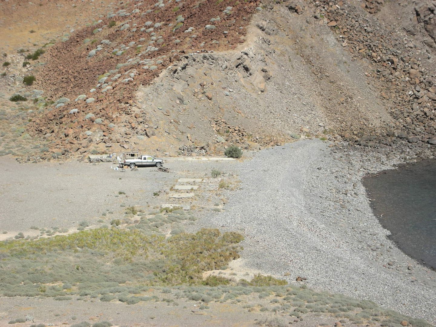
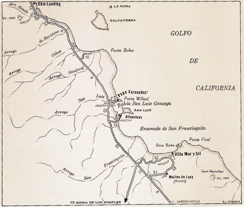
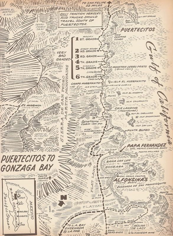
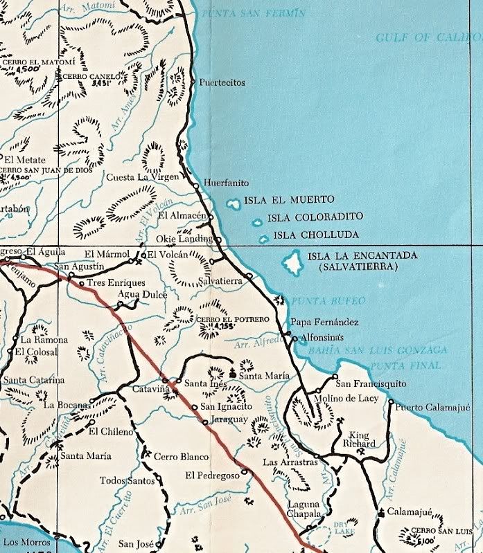
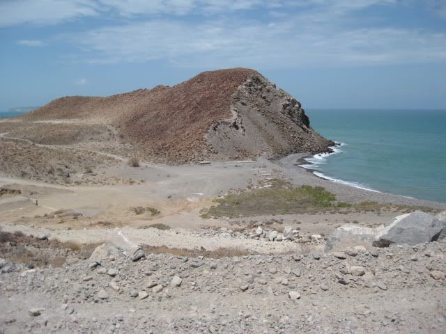
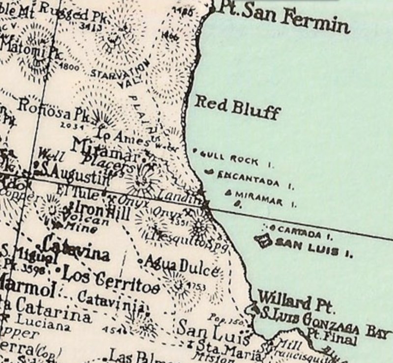
See what I can dig up tomorrow... for now, by searching Nomad I found some old maps and a recent photo, I had posted before:


In the 1960's I remember cabins on those slabs, and there was an ice house in the side of the cliff (for storing fish until the next truck arrived).


[Edited on 10-27-2021 by David K]

Pablito1 - 12-15-2013 at 09:29 AM

The first time that I went by Okie's landing was 1967. We were in a 1966 Volkswagen bug in route to Papa Fernandez camp to do some diving. I do not remember any cabins there but maybe I just don't remember. The only activity there that I ever saw was in about 1970 we stopped for a driving break and 3 Mexicans had a tarp rigged up for a shade. Under the shade was 16-17 turtles and they were waiting for the truck to come and haul them to the market.

Some days later these same people showed up at Papa's camp with more turtles.

Shi Shi Fernandez told me that Tony Reyes was the person that put in those cement floors but I don't know the time frame for that.

Regards, Pablo
Semper Fi

willardguy - 12-15-2013 at 10:38 AM

by gene kira

By about 1960, Tony was sending out as many as 70 anglers on a good Saturday, and he had also opened an ultra-remote fish camp at Okie Landing, 70 miles down the blistering hot desert coast. In those days, Okie Landing was a punishing eight-hour drive from Puertecitos, but the skiff fishing was worth it for nearby totoaba, black sea bass, and other species. Tony poured the six concrete slabs that are still visible there today, built some cabanas and a ramada, and stored ice in a hole that he dug into the mountain.

By 1962, Tony’s life was finally settled enough so that he married his wife of the last 42 years, the former Lolita Montez, of Bahia de los Angeles.

But there were still difficulties ahead. Okie Landing closed about 1973, as the very rough road deteriorated into truly impossible ruts, and the fishing within range of Tony’s small skiffs thinned out. Tony kept going by partnering briefly with Gustavo Velez in a long range boat business, and then chartering his own larger shrimp trawlers for trips into the Midriff.

David K - 12-15-2013 at 10:44 AM

I was thinking last night that I don't remember seeing any activity there on my trips of '74 and '75, so Gene's history seems right on. Thanks!

I heard a story that there was no name for the place originally, but the first group of gringo fisherman to stay there were from Oklahoma... or they invented the name Okie Landing, so Tony used that...???

willardguy - 12-15-2013 at 12:25 PM

hey bynro, scroll down to the bottom of this page and you'll find some great old photos of okies. https://www.wonews.com/t-OtheSpotFeature-Totoaba-BillBeebe-0...

BTW, the word on the beach is this will be the year we'll see a open totuava fishery!

David K - 12-15-2013 at 01:23 PM

Very cool photos ... used to be a WON subscriber... thank you for the link.

Pablito1 - 12-15-2013 at 02:28 PM

In the early 1980s I was with one of Papa Fernandez's grand sons and we were north of San Luis Island. He saw a panga in the distance that belonged to his friend so we went to talk to the guy. This guy was running a long line and in his boat was the largest totoaba that I have ever seen. The fish was at least 6 feet long.

Regards, Pablo

brewer - 12-15-2013 at 06:36 PM

Quote:
Originally posted by willardguy


BTW, the word on the beach is this will be the year we'll see a open totuava fishery!


Someone else mentioned this too. Where did you hear it from?

brewer - 12-15-2013 at 07:53 PM

Quote:
Originally posted by willardguy
hey bynro, scroll down to the bottom of this page and you'll find some great old photos of okies. https://www.wonews.com/t-OtheSpotFeature-Totoaba-BillBeebe-0...

BTW, the word on the beach is this will be the year we'll see a open totuava fishery!


Classic days. The ice cave was essential. Those fish go bad fast in the heat. Thanks for the post.

bynro - 12-15-2013 at 09:38 PM

Those are great, any more?

David K - 12-15-2013 at 11:13 PM

The link from willardguy beats what I was going to post... but I am glad my memory of the ice cave was correct... I was just a little kid! On Cliff Cross's 1970 map, he has it already abandoned. Maybe on the way out or seasonal?

David K - 12-15-2013 at 11:31 PM

Here's one taken in July, 2011:


bynro - 12-16-2013 at 03:31 PM

Everything beat what you posted DK.

Thanks for the link to the photos Willard Guy, Those are the only pictures I've seen of the camp in operation,
I was hoping there would be a few old guys still around that fished there back in the day. Maybe not?

mcfez - 12-16-2013 at 04:45 PM

David...........from what I have been reading about this "Ice" cave......the ice was brought in from across the border. Far back during ww2..... there is writings of hauling ice down to San Felipe and further......."they began their own business by hauling ice from across the border and transporting" from Randy's site http://www.blueroadrunner.com/aboutsf.htm

So it took forever to reach the Okie Landing back in the day.....just how did they get the ice there, your knowledge or your thoughts.......

Also.....that cave still there? I have been there a few times and never saw it....

Great maps DK

[Edited on 12-16-2013 by mcfez]

Barry A. - 12-16-2013 at 04:48 PM

I went by Okie's Landing in 1963 on our way to Gonzaga, and I don't recall any activity at that time, but the structures were up at that time if I remember correctly.

DK I love your maps and historical references, and your pictures------many thanks!!!

Barry

Some more early totoaba history

durrelllrobert - 12-16-2013 at 06:20 PM

www.mexfish.com/mexi/mexi/af051209/af051209.htm‎

Sometime in the early 1920s, a few American sport anglers had begun testing the waters around San Felipe, and in 1923, the first recorded totoaba--two fish--were exported to the United States.

In the beginning years of the San Felipe totoaba trade there was simply no market for the huge, six-foot-long carcasses left over after the buche (air bladder) had been cut out, dried and exported to China. The fish were left in haystack-sized piles to rot in the sun. When the smell and flies became intolerable, the fishermen and their families would simply move down the beach and set up a new camp.

Word got out about the enormous piles of wasted fish (due to the removal of the buche). Soon thereafter, buyers from the United States reached San Felipe in ice trucks specially equipped to make the 125-mile open desert crossing from the U.S. border at Calexico.

In the winter of 1924-25, 170,000 pounds of fish were hauled north to the Southern California market. The totoaba were bought on the beach for as little as five cents per fish, and sold at a tremendous profit.
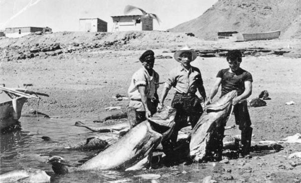

A commercial catch of enormous totoaba at Bahia San Luis Gonzaga, Baja California, Mexico. From left to right, Tony Reyes, Gorgonio Fernandez, and his son, Chi Chi Fernandez, c. 1954. --Reprinted with permission from The Unforgettable Sea Of Cortez.

[Edited on 12-17-2013 by durrelllrobert]

[Edited on 12-17-2013 by durrelllrobert]

willardguy - 12-16-2013 at 06:52 PM

take a look at the above photo then take a look the statue of chi chi. it was on the san felipe malecon but moved to the harbor after the new malecon fell into the sea during the big storm/high tide!


David K - 12-16-2013 at 07:42 PM

Quote:
Originally posted by bynro
Everything beat what you posted DK.

Thanks for the link to the photos Willard Guy, Those are the only pictures I've seen of the camp in operation,
I was hoping there would be a few old guys still around that fished there back in the day. Maybe not?


Sorry, I do try...

Can you get in there from the 'new' road?

neilm81301 - 12-16-2013 at 08:28 PM

From the INEGI topo, it looks like about N 30°05' - around the northing of Isla Muertos - is the recently improved road to Gonzaga very far removed from the one shown on the old maps?

Might be a place to camp - patio slabs and all!

Neil

[Edited on 12-17-2013 by neilm81301]

mcfez - 12-16-2013 at 09:33 PM

Great info find!
I'm going spend a little time to dig up more info on these trucks. Just the weight alone of the ice...and distance...wow!

Quote:
Originally posted by durrelllrobert
www.mexfish.com/mexi/mexi/af051209/af051209.htm‎

Sometime in the early 1920s, a few American sport anglers had begun testing the waters around San Felipe, and in 1923, the first recorded totoaba--two fish--were exported to the United States.

In the beginning years of the San Felipe totoaba trade there was simply no market for the huge, six-foot-long carcasses left over after the buche (air bladder) had been cut out, dried and exported to China. The fish were left in haystack-sized piles to rot in the sun. When the smell and flies became intolerable, the fishermen and their families would simply move down the beach and set up a new camp.

Word got out about the enormous piles of wasted fish (due to the removal of the buche). Soon thereafter, buyers from the United States reached San Felipe in ice trucks specially equipped to make the 125-mile open desert crossing from the U.S. border at Calexico.

In the winter of 1924-25, 170,000 pounds of fish were hauled north to the Southern California market. The totoaba were bought on the beach for as little as five cents per fish, and sold at a tremendous profit.


A commercial catch of enormous totoaba at Bahia San Luis Gonzaga, Baja California, Mexico. From left to right, Tony Reyes, Gorgonio Fernandez, and his son, Chi Chi Fernandez, c. 1954. --Reprinted with permission from The Unforgettable Sea Of Cortez.

[Edited on 12-17-2013 by durrelllrobert]

[Edited on 12-17-2013 by durrelllrobert]

David K - 12-16-2013 at 09:38 PM

Quote:
Originally posted by neilm81301
From the INEGI topo, it looks like about N 30°05' - around the northing of Isla Muertos - is the recently improved road to Gonzaga very far removed from the one shown on the old maps?

Might be a place to camp - patio slabs and all!

Neil

[Edited on 12-17-2013 by neilm81301]

Yes the last photo I posted was from the new hwy.

The name Okie Landing

azkmb - 8-7-2014 at 05:14 PM

I have no pictures but it looks like there are a few here. My grandfather Theodore Davidson (and his son Buz Davidson) and his brother James Davidson used to fish with Tony Reyes in the 50' around this area. Theodore and James where from Henrietta OK. Tony took to them well as they came back for more and more Totoaba. The stories I have been told are of giant fish everywhere! Anyway the story goes that Tony took to the Davidsons for all their loyalty and named Okie Landing after them. One day I hope to visit the area, with a fishing pole in hand!

bajabuddha - 8-7-2014 at 05:23 PM

Tew Kewl, azkmb! What you are looking at on your pics are now dodo birds and left-ish republicans. From San Felipe north the Sea of Cortez is a virtual wet desert. If you do head down, pole-in-hand, keep going south..........

David K - 8-8-2014 at 10:30 PM

Quote:
Originally posted by azkmb
I have no pictures but it looks like there are a few here. My grandfather Theodore Davidson (and his son Buz Davidson) and his brother James Davidson used to fish with Tony Reyes in the 50' around this area. Theodore and James where from Henrietta OK. Tony took to them well as they came back for more and more Totoaba. The stories I have been told are of giant fish everywhere! Anyway the story goes that Tony took to the Davidsons for all their loyalty and named Okie Landing after them. One day I hope to visit the area, with a fishing pole in hand!


That is some great history there! Thank you, and welcome to Baja Nomad. I remember activity there in the 1960's, but not in the 70's, as the road got so bad and traffic nearly stopped going between Puertecitos and Gonzaga after Hwy. 1 was finished... and not much other than SCORE races until that section got a new road built in 1986.

C205Driver - 8-9-2014 at 06:33 AM

David. . .Some folks have no desire to be well informed. . .

David K - 8-9-2014 at 10:38 AM

You are so right... ignorance is bliss, right?

One thing is for sure, anyone not wanting to be well informed should not read Baja Nomad! :yes:

Tioloco - 8-9-2014 at 01:00 PM

The maps are helpful. I could pull them out myself, but it is much easier when someone puts them up on this board. Gracias

willardguy - 8-9-2014 at 01:04 PM

Quote:
Originally posted by azkmb
I have no pictures but it looks like there are a few here. My grandfather Theodore Davidson (and his son Buz Davidson) and his brother James Davidson used to fish with Tony Reyes in the 50' around this area. Theodore and James where from Henrietta OK. Tony took to them well as they came back for more and more Totoaba. The stories I have been told are of giant fish everywhere! Anyway the story goes that Tony took to the Davidsons for all their loyalty and named Okie Landing after them. One day I hope to visit the area, with a fishing pole in hand!
here's another thought on the origin of the name.


This profile of Tony Reyes was written by Chuck Garrison and appeared in the December 2005 edition of Western Outdoors:

Slowly but steadily, Tony Reyes built up his own fleet of small pangas and guides, established a base camp at Okie's Landing near Isla Lobos (said to have been named after anglers who hooked and lost big fish, because they kiddingly "fished like Oklahoma farmers") and advanced his reputation as a rise-early, fish-hard, return-late guide who made his first priorities equal: fish catches and customer service.

[Edited on 8-9-2014 by willardguy]

BajaRat - 8-9-2014 at 04:44 PM

Super Cool azkmb, and if you can make the trip, it's nice outside of summer's insane heat.
Thanks to all for the great stories :cool:

C205Driver - 8-9-2014 at 09:34 PM

. . .David, again, thanks for your great help with anything Baja; I do not know everything , and your time & help makes it sooo much easier to learn about about a place I really enjoy. . .I am hoping that in the future the negative posters will become aware that we are all different, we all have different needs, we all have different learnings & that knowledge is a good thing. . . AND, I guess we all have differing opinions of ones posting on this open Baja forum, si, no?

David K - 8-10-2014 at 09:28 AM

Quote:
Originally posted by C205Driver
. . .David, again, thanks for your great help with anything Baja; I do not know everything , and your time & help makes it sooo much easier to learn about about a place I really enjoy. . .I am hoping that in the future the negative posters will become aware that we are all different, we all have different needs, we all have different learnings & that knowledge is a good thing. . . AND, I guess we all have differing opinions of ones posting on this open Baja forum, si, no?


Thank you for the nice words, they are appreciated. Like you, I come here to learn and to share. There is more Baja I do not know about than I do. I have been visiting the magic peninsula for almost 50 years and I still cannot get enough. Perhaps that is why I say 'magic', as it seems to keep amazing me at what new discoveries there are to be made or that some of the same places can never get old.

We all have different personalities and opinions and I do not let opinions determine who is cool or not, that is determined by actions. I have no need for hostility, and I have many friends here who do not share the same opinions as me, and I don't care. Our love of Baja should override the other stuff.

Have a great day, and if you think I can help or share with anything, please don't hesitate to ask! I sure don't know everything, but I do try to provide the best information on what I am fond of regarding Baja (History, Maps, Books, Camping, Four Wheeling). I am so lucky to have traveled the original main road the length of Baja in 1966, and have been old enough to remember it. In the 60's, my parents traveled many of the other roads in Baja as well, so the sense of exploration transferred to me.

David K - 10-27-2021 at 06:34 AM

Okie Landing chat :biggrin::cool:

bajaric - 10-27-2021 at 09:49 AM

Somehow, I got the idea that Okie landing was a prospecting camp.
A flood of "Okies" invaded the old mining districts in the 1930's. The tailings from dredging that took place during this period can be seen from space, for example at Snelling, CA.
could be wrong.


[Edited on 10-27-2021 by bajaric]

David K - 10-27-2021 at 11:11 AM

Good idea, Ric... Who can say for sure?
I often defer to the excellent Lower California Guidebook when it comes to history, up to 1962.

Per the 1962 book:
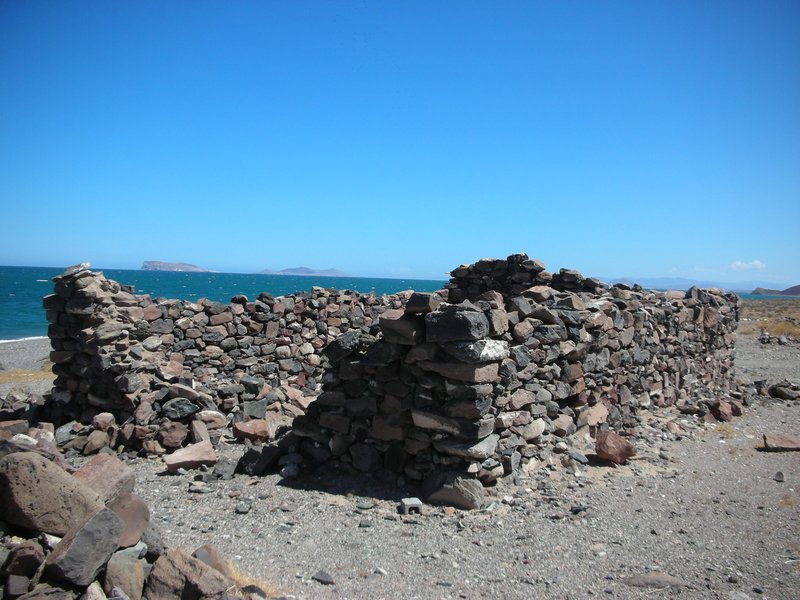
Okie Landing was a place where boats could be rented for fishing, which used to be amazing here. It is (or was) 2.8 miles south from El Almacén, the stone ruin which was a warehouse constructed for the Miramar area gold mines (placer mines).


Sept. 2008 photo of El Almacén.

I think this warehouse would be closer to where supplies were offloaded and gold loaded on, not 2.8 miles away? The old maps call this site or nearby, 'Miramar' no map has Okie Landing until much later. It is on the 1962 AAA map (as 'Oakies Landing') but not the 1959 map.

It is on the 1962 Lower California Guidebook map and road log, but not in the 1958 edition.

Howard Gulick (the guidebook's author) traveled the 'new' road through here in 1956 (for the '58 edition) and again in 1960 (for the '62 edition). The 1956 (1st) edition researched in 1955 and earlier finds the road south of San Felipe went no further than the sulfur mine and Agua de Chale, southbound. Coming north, a vehicle could get as far as San Luis Gonzaga Bay in a 4WD vehicle via the Pioneer mine and Molino de Lacy.

This evidence would seem to indicate Okie Landing started after 1956 and for sure by 1960 when Gulick traveled there. The AAA guide of 1959 does not mention Oakies [sic] Landing but the 1962 one does.


On this 1930 Map, we do see a 'Landing' between Miramar Placers and an onyx site & Mesquitito Spring, but it could be either at El Almacén or Okie Landing on this slightly crude map.


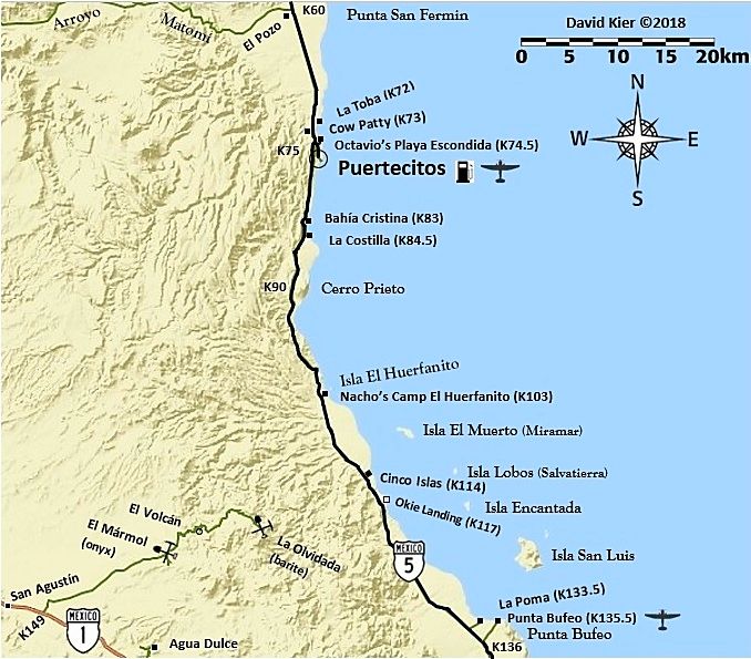
Today, you can get to El Almacén from Cinco Islas (Km. 114) and drive north a short distance on the older road, which is just east of the highway.

Okie Landing can be seen from the new highway at Km. 117. The access is just north of that kilometer marker.


rts551 - 6-25-2022 at 10:32 AM

And now another reason for this area to be infamous. https://www.lavozdelafrontera.com.mx/policiaca/localizan-fos...


AKgringo - 6-25-2022 at 10:49 AM

I am guessing there is a translation error in the article. The grave is reported as being 1.8 meters wide, and 250 meters long! That is trench, not a grave!

David K - 6-25-2022 at 10:57 AM

They left out a decimal, I bet? 1.80 meters wide by 2.50 meters long, seems likely.

rts551 - 6-25-2022 at 04:11 PM

2.5 - maybe one of our missing....article insinuates 1 grave and bones.