BajaNomad

Pole line on Monday

PaulW - 1-29-2014 at 08:49 AM

http://share.findmespot.com/shared/faces/viewspots.jsp?glId=...

Quick summary More later
Spent 14 hours in the Bronco doing the trip. We ended up on the race track from last summer.
Big problem getting around the barricade My Bronco fell off the big rock and my buddy used his winch to drag me back. I got out of the way and he passed the gate and we strapped the big rock that was giving me trouble and placed it in a good position and I was able to drive thru. My problem was the spool made me slide toward the gate and my WB would not allow the sharp turn.
I followed Murdock, but he has a lot of inaccuracies. But WPs given to me by Nomads allowed me to find the turns. Now I have added more WPS for the critical turns. I made several errors costing us over 2 hours to recover. Sigh.. Which accounts for the long time for the trip.

Nothing like 14 hours of rock crawling.
BTW, the race course is devastated from summer floods. That slowed us down for stacking rocks and finding go arounds. Could not get to nuevo jct due to all the new fencing. We followed the fence lines and eventually found unlocked gates. More slowing for the trip. The ranchers have spent a huge amount of money doing the fencing and the fences are very professionally done.
After the summit we were in the dark with no moon so I suppose there are roads that I could have taken to get to N Jct? Hard to find in the dark with the tunnel vision from the bright lights. We found 3 burned out late model trucks and a Suzuki that had been tumbled down the cliffs of Jaquegel

3 TJ Jeeps (short WB) plus me and 6 guys. That road works with 33" tires on the Jeeps. None them had to use their lockers. I led so Joel and I did on the rock work to fill in the huge holes from the storms.
If one were to drive the road from west to east is would be much easier.
I have cleaned up the GPS files but both the USR and GPX files are to big to attach. I need to find a place to put them as a link.
Later
Regards, Paul

[Edited on 1-29-2014 by PaulW]

Pole line USR file

PaulW - 1-29-2014 at 09:36 AM

See attached compressed (ZIP) USR file.
Extract it and convert it to a KML or GPX as desired.
I tried to compress the other formats and they are still to big to attach.
You can view GPS files using the free SW called "Trackmaker" and it has the buttons to do all kinds of format conversions. Easypeasy.
Paul

Attachment: PoleLineTrack (2).zip (24kB)
This file has been downloaded 302 times


TMW - 1-29-2014 at 02:48 PM

Glad you made it. Fun trail as long as you don't have serious problems.

Where is the barricade and the big rock located?

PaulW - 1-29-2014 at 07:04 PM

Quote:
Originally posted by TW
Glad you made it. Fun trail as long as you don't have serious problems.

Where is the barricade and the big rock located?

=======
The barricade is at the transition to the race road. So we went down the hill toward the race track passed the barricade made a sharp left and started up to the summit.
3" bar with an enclosed padlock. Maybe its new because there was lots of concrete spillage at it supports. My Bronco has a 120" WB and I could make the sharp turn. Its good for long WB now. Based on the tracks we followed it appeared several Jeeps drove around the barricade before we did. I think they made the go around to pass the Chevy crew cab that was blocking the Basket ball hill track. See WP "Truck".
Barricade: 31 37.78774', -115 35.15398' Yellow exclamation WP.

Found a 2 burned out late model trucks, One stripped Dodge extended cab shoved down the bank and the Suzuki. I had to work on the passenger door mirror, and put a plug in a tire with a slow leak. Biggest issue wad finding the correct trail
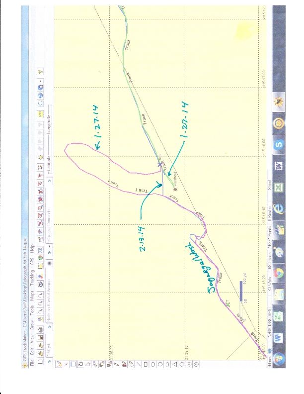
Nothing serious. Look at the GPS track for the first entrance to Jaquegel. There is a major washout there and a steep descent to get into he wash. That took us 2 hours to find the detour. Again the guys that went before us had it scoped out. Wish they had marked the turn
PW

David K - 1-31-2014 at 10:04 AM

Ken Cooke's Rubicon group?

PLR track ?

PaulW - 1-31-2014 at 04:47 PM

Looks like 40 have downloaded the compressed GPS file so far.
Please give me some feedback on success of failure creating a GPX or KML file
Thanks, Paul
==========
Quote:
Originally posted by PaulW
See attached compressed (ZIP) USR file.
Extract it and convert it to a KML or GPX as desired.
I tried to compress the other formats and they are still to big to attach.
You can view GPS files using the free SW called "Trackmaker" and it has the buttons to do all kinds of format conversions. Easypeasy.
Paul

TMW - 1-31-2014 at 06:08 PM

Paul I had no problem converting the to a KML file for Google Earth. I used http://www.gpsvisualizer.com/

PLR Update

PaulW - 2-27-2014 at 05:07 PM

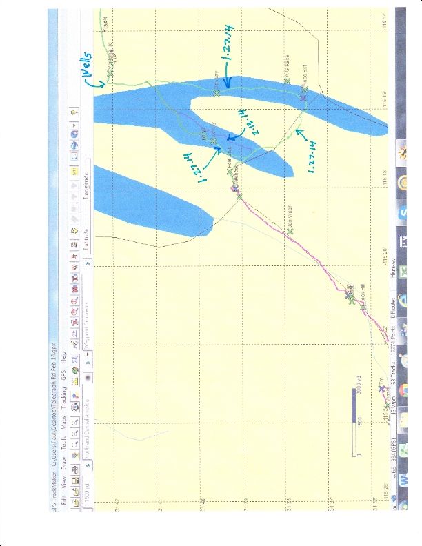
The week after my trip on 1/27 another group of 3 jeeps did the Pole line from Ventana. They reported that the barracide padlock was missing. The took the ancient road from the Ventana road directly to the wash. I asked for them to give me that track as it avoids the drive either cross country or way south along Arroyo Grande.

Then another group of prerunners went up the race summit and tried to return by the low road and the gate was locked so they had to descend on the race track. I think that was on 2/19 or so. No surprise, I suspect all those new gates we found unlocked are now all locked during race activity.

Now I find there is much interest from the local SF guys and I expect there will be several more PLR trips in the next few weeks.
Paul

David K - 2-27-2014 at 05:22 PM

Please keep us posted and share photos and maps when you can! Many thanks!!

Update 2

PaulW - 2-28-2014 at 10:19 AM

I just got the track for the other trip in 2/13/2014 which shows the alternate track from the Ventana road and the alternate at the washout to enter Jaquegel.
The 2/15 track is from a Garmin Nuvi so I think there are lots of missing breadcrumbs??. The 1/17 track has excessive breadcrumbs, thus is very accurate and can be trusted. As the guys make more trips I will post what I know.
Paul


David K - 2-28-2014 at 12:30 PM

Hi Paul,

It hurts my neck to look at the sideways maps, so I hope you don't mind that I straightened them around and enhanced them a bit?