BajaNomad

The history and purpose of this causeway?

StuckSucks - 3-17-2014 at 04:18 PM

Does anyone know the history and purpose of this causeway? It extends east from Highway 5, just north of La Ventana, into the Rio Colorado floodplain. We only went as far as the first breach at 1.28 miles. Google Maps shows the overall length at around 11.65 miles.

I'll bet a month's pay that David K knows.


[Edited on 3-17-2014 by StuckSucks]

Ateo - 3-17-2014 at 04:24 PM

This ought to get interesting. Can't wait to hear the history, if it's known.

DavidE - 3-17-2014 at 04:31 PM

WW II ??

Army Corps of Engineers moved a lot of dirt back then?

woody with a view - 3-17-2014 at 04:47 PM

it seperates salt mining claims.

StuckSucks - 3-17-2014 at 04:49 PM

Here's a view of the breach from Google Maps.


Kgryfon - 3-17-2014 at 05:01 PM

Woody, is that a guess?

Udo - 3-17-2014 at 05:27 PM

I could be mistaken, but I seem to recall that the north side of the causeway was full of water as part of the runoff catch basin for the Colorado river before it was damed up in the US side.
There was actually a small community that was living off the fishing in the lake created. I do not remember when the breach occurred, but at times, the water was all the way to the hills at the south end of the lake (there are some large sand dunes in that area). And at that time both sides were also full. That's how much water was coming down the Colorado river!
I believe the water lasted until about the mid 80's.

As I said earlier...I'll stand corrected, if someone knows more details than I have provided.

woody with a view - 3-17-2014 at 06:27 PM

yes.

vgabndo - 3-17-2014 at 06:38 PM

The only similarity with the roads around the Sierra Santa Clara is that these here are also straight as a string for about 15-20 miles. They go from a road to a no-where place and stop. Jaime Morales, the Bioshphere guy here, says they were put in my the oil companies drilling test wells. He says he knows personally of 4-5 abandoned well heads confirming the story.

The Road to .............

MrBillM - 3-17-2014 at 07:16 PM

The Shrimp Farm.

LaTijereta - 3-17-2014 at 08:19 PM

Quote:
Originally posted by MrBillM
The Shrimp Farm.


Is that code for the "Bunny Ranch"?

David K - 3-18-2014 at 09:48 AM

That road is fairly new... and by new, I mean not over 20 years old. Now, a road that went to La Bomba was 17 miles north of La Ventana... Flat-bottomed riverboats used to travel up the Colorado to bring supplies to Yuma, previous to the railroad arriving in 1877. La Bomba was a port facility from the 1930's.

Plenty more riverboat history... Port Isabel has some history, too... It was closer to El Golfo de Santa Clara...

[Edited on 3-18-2014 by David K]

villafontana - 3-18-2014 at 09:55 AM

So who lost the bet StuckSucks?? Lol

David K - 3-18-2014 at 10:00 AM

The photos Stucks posted are great... Every road in Baja goes somewhere interesting!

How OLD ?

MrBillM - 3-18-2014 at 10:15 AM

It "seems" that I remember it being built in the late '80s, but it could have been early '90s.

I've got photos somewhere from its first days.

At THAT time, there was a large government sign giving the particulars on the (later failed) Shrimp Farm for which it was built. It was being lauded at the time as a tremendous boon to the economy.

Like so many things which have failed over the years.

I had heard that it was a victim of the "White Spot Syndrome", but I've never seen any confirmation. The time period is right, though.

There is a poor quality short video which "appears" to be THAT Shrimp farm from the background, but Quien Sabe.

The farm was quite aways out as the road would indicate. I once drove out that way and, of course, met a truck heading the other way. After he passed, I turned around.

Barry A. - 3-18-2014 at 03:31 PM

My 2 cents (which is more than they are worth on this subject):

The USA released a "pulse" of Colorado River Water into Mexico in the '80's which was big enough to overflow from the Delta into the Laguna Salada and partially fill it. This "filling" was caused because a huge flat natural "dam" had built up on the Colorado Delta due to the river previously for years never reaching the SOC coupled with high tides from the SOC. In addition there were several man-made causeways running E and W that served as an additional dams. Until that natural dam was slowly breeched (which it was), as well as the causeways, the water backed up and overflowed into the Laguna Salada, gaining access under the N/S San Felipe highway thru huge culverts. I used to know what the "causewas" were used for, but I can't now remember. Whatever it was, it was not that successful, I don't think.

There is another "pulse" to be released this Spring, and in fact may already be happening. This pulse promises to be a big one despite the drought. I have friends that plan to run the "surge" from just below Moreles Dam down to the SOC in inflatable canoes this time. We had tried to do that back in the '80's but were stopped by jungle-like vegatation blocking our progress above Yuri-Muri. Even so we had a great canoe trip for 2 full days before we were stopped. The delta is virgin country, and a wildlife bonanza. We made numerous outboard trips out on the '80's 'surge' from Yuri-Muri, both up and down the river. Great adventures. My son and a friend actually saw the famous TIDAL BORE on one of those boat trips where they spent the night far out on the Delta along side the main channel of the river.

This does not explain the "causeways" but gives you some background on the Delta, I hope.

Barry

StuckSucks - 3-18-2014 at 03:55 PM

Quote:
Originally posted by Barry A.
There is another "pulse" to be released this Spring, and in fact may already be happening. This pulse promises to be a big one despite the drought. I have friends that plan to run the "surge" from just below Moreles Dam down to the SOC in inflatable canoes this time.


Coincidentally, I bumped into this surge info this morning. They'll let water out of the Morelos Dam on March 23.

U.S. and Mexico Unleash a Flood to Restore Colorado River Delta

[Edited on 3-19-2014 by StuckSucks]

David K - 3-18-2014 at 04:01 PM

Mexicans tried to make a Salton Sea-like lake out of Laguna Salada in the 1980's with a huge canal to channel Colorado water into the upper Laguna Salada. When their levee failed, the lower Laguna Salada (that Hwy. 5 crosses) became flooded... it had water on it for many years.

The Laguna Salada Flooding

MrBillM - 3-19-2014 at 10:17 AM

Occurred (1981) as a result of a HUGE "safety" release on the Colorado River after an extraordinary rain season (and poor management) had resulted in a possibly dangerous storage level.

Unaware of how dramatic the effect had been, I traveled Hwy 5 to San Felipe in February during that time as they were raising the highway across Laguna Salada.

Each direction over that stretch took around 45 minutes over incredibly BAD terrain clogged with traffic and construction equipment.

N2Baja - 3-19-2014 at 12:12 PM

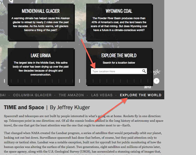
http://world.time.com/timelapse/

This is a cool site from National Geographic where you can see an aerial timelapse of the area from the early 1980's to current. Click on "Explore the World" (bottom right on the grid) and navigate to the area you'd like to see.

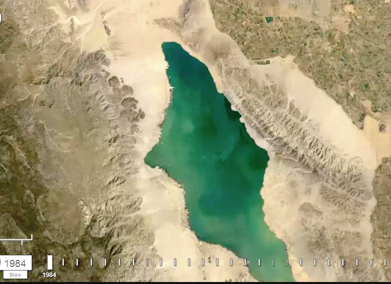
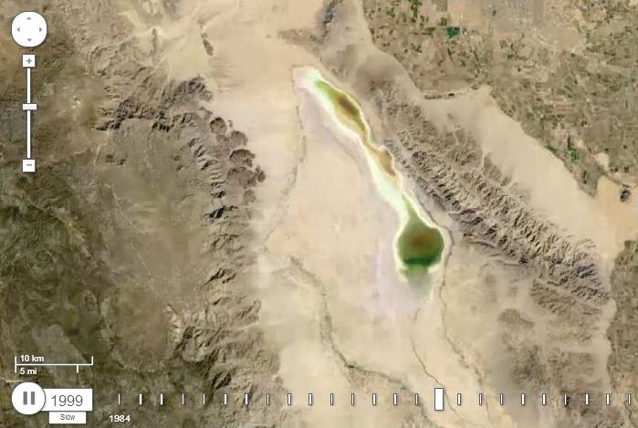
Its interesting to see the water drain from Laguna Salada over the years. I didn't look too closely, but maybe you can find the causeway.

Udo - 3-19-2014 at 12:31 PM

That's a cool site, N2!

Thanks!

David K - 3-19-2014 at 02:05 PM

Quote:
Originally posted by N2Baja
http://world.time.com/timelapse/

This is a cool site from National Geographic where you can see an aerial timelapse of the area from the early 1980's to current. Click on "Explore the World" (bottom right on the grid) and navigate to the area you'd like to see.

Its interesting to see the water drain from Laguna Salada over the years. I didn't look too closely, but maybe you can find the causeway.


Grid? Please help me find this grid so I can look too... Thanks!

N2Baja - 3-19-2014 at 02:37 PM

Quote:
Originally posted by David K
Quote:
Originally posted by N2Baja
http://world.time.com/timelapse/

This is a cool site from National Geographic where you can see an aerial timelapse of the area from the early 1980's to current. Click on "Explore the World" (bottom right on the grid) and navigate to the area you'd like to see.

Its interesting to see the water drain from Laguna Salada over the years. I didn't look too closely, but maybe you can find the causeway.


Grid? Please help me find this grid so I can look too... Thanks!

.
Sorry, when you click the link there will be a photo of Dubai, along the bottom on the right hand side it says "Explore the World" Click that

StuckSucks - 3-19-2014 at 05:17 PM

1. Click on Explore the World, lower right
2. One the resulting page, enter a location to explore


Thank you for trying to help me!

David K - 3-19-2014 at 05:52 PM

Okay... I found it... Thanks!

[Edited on 3-20-2014 by David K]

Laguna Salada 1984, 1990, 1999

David K - 3-19-2014 at 06:06 PM


[Edited on 3-20-2014 by David K]

Photo Sphere of the causeway

StuckSucks - 1-26-2015 at 03:07 PM

Photo Sphere of the causeway

Kgryfon - 1-26-2015 at 04:57 PM

Very cool

Causeway/1983/1984 Flood

okiegumbo - 1-27-2015 at 09:42 AM

The exact date is a little foggy. There was a major release of water on the Colorado river as a result of high run off from the winter snow pack (NY Times July 17, 1983). The resulting flood caused several deaths and millions of dollars in damages along the river below Parker Dam. It also flooded the Colorado river delta. Traveling to San Felipe during that time I witnessed a bucket crane building a channel/causeway from the highway west toward the mountains. Houses along the Rio Hardy were flooded up to the roofs. The water was raging through large culverts under the highway into Laguna Salada. Sometime later, several friends and I explored the area in an Avon inflatable. The water was still raging into Laguna Salada. (Pictures on Google) There were numerous small commercial fishing operations along both sides the highway. Apparently the flooding of the delta created a explosion in the fish population (bass and catfish). There were a gazillion birds. During our exploration we became lost in the cattails and stumbled upon several small boats with jetdrives on their outboards, The boats, men and even the guns were camo! It scared the beejeezes out of us until we realized they were duck hunter. There were duck hunters everywhere. I believe there may be a National Geographical article or TV documentary on the aftermath of the flood. Lots of info on Google. I assumed at the time the channel was to relieve the flooding along the Rio Hardy or an attempt to create a permanent water supply to Laguna Salada.

FLOODS ALONG COLORADO RIVER SET OFF A DEBATE OVER BLAME

StuckSucks - 1-27-2015 at 12:34 PM

http://www.nytimes.com/1983/07/17/us/floods-along-colorado-r...

David K - 1-27-2015 at 06:00 PM

Too much water in 1983, not enough 30 years later! Everything works in cycles...