BajaNomad

Road east of Coco's Corner

beachbum1A - 4-2-2014 at 12:17 PM

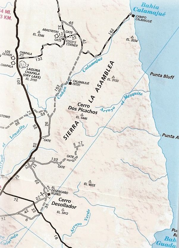
Looking at Google Earth you can spot a road/trail leaving Coco's Corner heading east about 22 miles to the fish camp at Calamajue, there on the SOC.
Was thinking of driving that road pulling a small tin boat for some fishing/camping and wondering about the condition of the road? Most certain it would be a lesser quality than the road through CC, but, going slow - is it doable?

Have driven from Gonzaga Bay to Hwy 1 several times but never cut off and tried driving east out towards Calamajue. So, any ideas or suggestions?
Thanks.

willardguy - 4-2-2014 at 12:24 PM

last trip out there the road that was in excellent shape had suffered a good size wash out and the sandy detour would have been difficult pulling a boat, it was sketchy for a 2WD ranger. this was many months ago so it may be repaired. or it may be worse! its one of our favorite side trips

[Edited on 4-2-2014 by willardguy]

beachbum1A - 4-2-2014 at 01:43 PM

Quote:
Originally posted by willardguy
last trip out there the road that was in excellent shape had suffered a good size wash out and the sandy detour would have been difficult pulling a boat, it was sketchy for a 2WD ranger. this was many months ago so it may be repaired. or it may be worse! its one of our favorite side trips

[Edited on 4-2-2014 by willardguy]


Thanks, appreciate the info.

TMW - 4-2-2014 at 02:13 PM

Stop by and ask Coco. He should know the road condition.

David K - 4-2-2014 at 02:48 PM

We used 6.3 miles of that road east from Coco's, in 2012, at which point we took the south fork to go to Molino de Calamajué (6.6 mi.), Misión de Calamajué (7.2 mi.), Cañon de Calamajué (8-12 mi.) and Highway 1 at El Crucero (21.7 mi.).

edit: above are my mileages and they are a bit less than AAA map indicates (6.3 vs. 6.6 to fork, and 21.7 vs. 24.5 to Hwy. 1).

That 6.3 mile part was an easy 2WD graded road. It is about 16 more miles on to Puerto (or Bahía) Calamajué from the fork, per AAA.


PS The shortcut to Hwy. 1 out of the canyon was 14.8 miles south of the fork (AAA says 15.3). The shortcut road on to El Crucero, Hwy. 1 was 6.9 miles (AAA says 9.2).

[Edited on 4-2-2014 by David K]

redhilltown - 4-2-2014 at 11:24 PM

Coco never seems happy about what is going on down at Calamajue and the people/fish camps that come and go there. As stated, the road changes depending on time of year and wash outs. The beach itself is not the easiest to launch a tin boat from but not the worst...if car-topping the boat I would say for sure but as for trailer I just don't know...Gene Kira's book "The Baja Catch" has some info on it and while dated still has some good advice.

When are you thinking of going?

http://www.mexfish.com/sflp/sflp/calmmp/calmmp.htm

beachbum1A - 4-3-2014 at 07:22 AM

Quote:
Originally posted by redhilltown
Coco never seems happy about what is going on down at Calamajue and the people/fish camps that come and go there. As stated, the road changes depending on time of year and wash outs. The beach itself is not the easiest to launch a tin boat from but not the worst...if car-topping the boat I would say for sure but as for trailer I just don't know...Gene Kira's book "The Baja Catch" has some info on it and while dated still has some good advice.

When are you thinking of going?

http://www.mexfish.com/sflp/sflp/calmmp/calmmp.htm


Looking at the last of October for our trip. The boat/trailer are fairly light (considering) with the motor, fuel, water, etc. being carried in a tow vehicle. Slow & easy of course. Have read "The Baja Catch" too. This is one of the places we haven't been to yet and would like to check it out - and fish of course.

beachbum1A - 4-3-2014 at 07:26 AM

Thanks David, always appreciate your maps!!

willardguy - 4-3-2014 at 10:08 AM

I can see beach launching there treacherous to say the least! but you have to give it a look! :P this was the road last time out.


beachbum1A - 4-3-2014 at 05:01 PM

ROAD? Oh yea, right!
Seriously, that would make it pretty interesting - not necessarily impossible, just more difficult.

TMW - 4-4-2014 at 10:30 AM

It's called a Baja Adventure

beachbum1A - 4-4-2014 at 07:43 PM

Quote:
Originally posted by TW
It's called a Baja Adventure

Exactly! And isn't that what our lives are all about?

redhilltown - 4-5-2014 at 12:01 AM

October is a perfect time and you know what you are doing. If slow and easy then a trailer really isnt any problem. The guys a couple of years ago at the fish camp were very cool and helped us launch (via a cold Tecate payment or two but well worth it!).

Will be down there soon and will report back.

beachbum1A - 4-5-2014 at 07:04 AM

Quote:
Originally posted by redhilltown
October is a perfect time and you know what you are doing. If slow and easy then a trailer really isnt any problem. The guys a couple of years ago at the fish camp were very cool and helped us launch (via a cold Tecate payment or two but well worth it!).

Will be down there soon and will report back.


Sounds good. Do you have a picture or two from your previous trip you could post, particularly of the beach and launch area?

David K - 4-5-2014 at 11:42 AM

Several photos from The Baja Kid at Puerto (Bahia) Calamajue in this thread: http://forums.bajanomad.com/viewthread.php?tid=47613

treuboff - 4-5-2014 at 12:26 PM

In your opinion, do you think the water at Calamajue is worth diving?

redhilltown - 4-5-2014 at 11:08 PM

Sorry about no pics beach but there are plenty on here. Soft sand as to getting too close to water...and launching is over this soft sand/rocks. There is a bit of trash here from over the years fish camps but still I like the area...once you get around the point and look south at all the steep cliffs and walls it is an awesome sight...not many in small boats have done it would be my guess! Watch the winds... but you knew that.