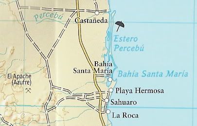
Read below. 'Shell Island' is not island. It's a barrier spit, part of the beach it's connected. Whatever that beach is called, that's what 'Shell
Island' is named. Since it encloses Percebu Lagoon that's it's true name. Islands are permanently completely bordered by water.
http://www.fws.gov/cbra/Act/Coastal_Barriers.html
Types of Coastal Barrier Landforms
Coastal barrier landforms may be described by their relationships to the mainland as bay barriers, tombolos, barrier spits, and barrier islands.
Additional areas which function as coastal barriers include dune and beach barriers, and fringing mangroves. The term "mainland" includes the
continental land mass as well as large islands such as Long Island, New York and the Hawaiian Islands. Definitions of the various kinds of coastal
barriers follow:
Bay barriers - coastal barriers that connect two headlands, and enclose a pond, marsh, or other aquatic habitat. The terms bay mount bar and bay
bar are synonymous.
Tombolos - sand or gravel beaches which connect one or more offshore islands to each other or to the mainland. The terms connecting bar, tie bar,
and tying bar are synonymous.
Barrier spits - coastal barriers that extend into open water and are attached to the mainland at only one end. They can develop into a bay barrier
if they grow completely across a bay or other aquatic habitat. On the other hand, bay barriers can become spits if an inlet is created.
Barrier islands - coastal barriers completely detached from the mainland. Barrier spits may become barrier islands if their connection to the
mainland is severed by creation of a permanent inlet. The barrier island represents a broad barrier beach, commonly sufficiently
above high tide to have dunes, vegetated zones, and wetland areas.
Dune or beach barriers - broad sandy barrier beaches, with hills or ridges of sand formed by winds, which protect landward aquatic habitats.
Fringing mangroves - bands of mangrove along subtropical or tropical mainland shores in areas of low wave energy. Many of these areas are located
behind coral reefs, which together with the mangroves themselves, provide significant protection for the mainland from storm impact.
|


 .
.


