BajaNomad

Recent rains

sargentodiaz - 10-14-2014 at 11:56 AM

With the exception of the Laguna Mountains at the very south of the peninsula, the remainder of Baja is desert. From the geology I've studied, most water simply runs off without soaking into the ground.

With all the recent rains, was their flooding? Or, have dams been built to hold it back? Other than the damage done to del Cabo, what is the general condition of Baja?

Thanks. :cool:

motoged - 10-14-2014 at 12:00 PM

Quote:
Originally posted by sargentodiaz
..... From the geology I've studied, most water simply runs off without soaking into the ground......With all the recent rains, was their flooding?


Yes, there was a significant amount of excessive water "running off"....and it is reasonable to consider this as "flooding".

Not a lot of dams in Baja....

bajabuddha - 10-14-2014 at 12:13 PM

Sr. Diaz, there are quite a few threads on the last two pages of 'today's posts' that detail the amount of damage and flooding experienced from San Quintin south to the Cape. Let your fingers (and mouse) do the walking and your screen do the talking; quite the history written here in the last month.

Far's dams, there aren't any major ones i'm aware of. Mulege had some fairly large earth-moving done in the valley above town to try to stem the next flood, which they certainly got. The water still rose, the town still went underwater, and all the earth moved came down with more mud than usual. So much for 'flood control', although I think the jury is still out on whether it reduced the initial flood or not. One would have to compare the amount of rainwater per hour compared to Jimena's flood and then extrapolate the data between the two storms and height of the flood to see if it was helpful or not.

Over the years I've seen the same arroyos in Baja flood, wash out the bridge, and a new one built to be blown out a few years later, and rebuilt. It's El Spitiu Baja; it rains, it floods, they rebuild. La Vida Loca, La Vida Buena.

David K - 10-14-2014 at 12:21 PM

I sure wouldn't call the pine forests and mountain meadows of the Sierra Juarez, and Sierra San Pedro Martir a desert. They are higher than the Laguna Mountains of the Cape region.

Also, while dryer than we may like, the coastal slopes to the Pacific Ocean of Southern California and northern Baja California are Mediterranean or semi-arid rather than true 'deserts'.

There are very few dams in Baja... a list of them may be interesting? The Rodriguez dam in Tijuana and the El Ihuajal (Ihuagil) dam southeast of Ciudad Constitucion are the only two I can think of, other than small dams like at Mulege and other mission sites.

Jack Swords - 10-14-2014 at 01:15 PM

Two dams in Baja Sur are solid concrete, spillway, and equal to dams in the US. One behind La Paz (Buena Mujer) holds back a very nice lake. One just N of Todos Santos is solidly built, but water flows underneath it, no lake.

Bajaboy - 10-14-2014 at 01:18 PM

the Las Auras dam was just completed in Tecate
http://mexicoperspective.com/Las-Auras-Dam-in-Tecate-inaugur...

Mexitron - 10-14-2014 at 01:24 PM

Quote:
Originally posted by David K
I sure wouldn't call the pine forests and mountain meadows of the Sierra Juarez, and Sierra San Pedro Martir a desert. They are higher than the Laguna Mountains of the Cape region.

Also, while dryer than we may like, the coastal slopes to the Pacific Ocean of Southern California and northern Baja California are Mediterranean or semi-arid rather than true 'deserts'.

There are very few dams in Baja... a list of them may be interesting? The Rodriguez dam in Tijuana and the El Ihuajal (Ihuagil) dam southeast of Ciudad Constitucion are the only two I can think of, other than small dams like at Mulege and other mission sites.


Not to mention the patches of Juniper, Oaks, and Chaparral that run along the mountaintops in Central Baja at least down to the Tres Virgenes.

David K - 10-14-2014 at 01:37 PM

Quote:
Originally posted by Jack Swords
Two dams in Baja Sur are solid concrete, spillway, and equal to dams in the US. One behind La Paz (Buena Mujer) holds back a very nice lake. One just N of Todos Santos is solidly built, but water flows underneath it, no lake.


I remember now the photos you took of the dam and lake it made, at El Oro: http://vivabaja.com/swords/page8.html


rts551 - 10-14-2014 at 01:49 PM

The morelos dam is operated by Baja Califoria even though its eastern boundary is in the US

Jack Swords - 10-14-2014 at 03:34 PM

I had forgotten about that dam, David. It's kinda old and rough compared to the other two I mentioned. Still, a dam with a small lake. Thanks for remembering.

MMc - 10-14-2014 at 03:58 PM

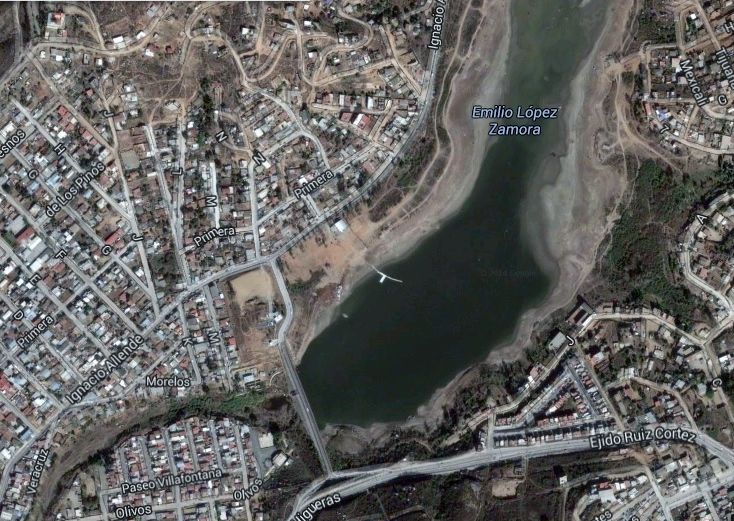
There is a water control dam in Ensenada, I believe its called Emillo Zamora, in June it was very low. The other dam in Baja (N) is along the 2000 rd. I don't know it's name those are the only two that I am aware of in Baja Norte.

David K - 10-14-2014 at 05:03 PM

Quote:
Originally posted by MMc
There is a water control dam in Ensenada, I believe its called Emillo Zamora, in June it was very low. The other dam in Baja (N) is along the 2000 rd. I don't know it's name those are the only two that I am aware of in Baja Norte.


The Rodriguez dam of Tijuana creates the lake that goes to the edge of the Corredor 2000.

Gulliver - 10-15-2014 at 06:19 PM

Can we count dams that are all silted up? There's one in the little town of Boca de la Sierra up the road from Miraflores.

Alm - 10-15-2014 at 06:56 PM

Diaz, guys are correct. There are few threads, each covering particular area: Cabo, Mulege, Bay of LA.

They don't do much to prevent future floods. In some places it's more difficult to do though. One place that would definitely benefit from a drainage canal, is Bay of LA. 2km long ditch from big arroyo next to air strip, to the sand spit North of town. Even it it fills up, it will still remove "some" water, enough to prevent many floods and to reduce the consequences of most severe ones. Not to mention keeping the town airport from being flooded. Cement is cheap, labor is cheap. Will they do this? Heck no.

Ensenada Dam

bajaguy - 10-15-2014 at 08:05 PM

https://www.google.com.mx/maps/@31.8926273,-116.6021034,1239...

Thanks!

David K - 10-16-2014 at 08:26 AM

Quote:
Originally posted by bajaguy
https://www.google.com.mx/maps/@31.8926273,-116.6021034,1239...


carlosg - 10-16-2014 at 10:10 AM

Quote:
Originally posted by David K
Quote:
Originally posted by MMc
There is a water control dam in Ensenada, I believe its called Emillo Zamora, in June it was very low. The other dam in Baja (N) is along the 2000 rd. I don't know it's name those are the only two that I am aware of in Baja Norte.


The Rodriguez dam of Tijuana creates the lake that goes to the edge of the Corredor 2000.


Wow!!!
I've seen the links on your signature but never really put any attention, today I clicked on one and found out that you are David K's Baja Adventure... I have been using your website as a reference point to plan my adventures into Baja, not to say that I'm a seasoned traveler but have done my share, now I'm teaching my children to be Baja lovers and it seems like its sinking in there... thanks for all you shared knowledge :D ... by the way, regarding the dam in TJ, some time ago I was told the dam looses a great deal of water because it sits on top of a 20ft. wide fault that drains it: go figure (see photos 3 & 5 on link, search for word "falla" on document)... I remember driving with my parents over the dam to go from TJ to Tecate, this was the ONLY east exit from Tijuana and you can imagine the traffic: buses and trucks vs cars everyone going the opposite way and loosing their side mirrors on the narrow bridge... it was fun to watch a truck and a bus meet at the curve, everyone stopped to watch the event... here's a link that even though is in Spanish it has great info and pics:

http://www.tijuana.gob.mx/ciudad/CiudadLaPresa.aspx

[Edited on 10-16-2014 by carlosg]

sargentodiaz - 10-17-2014 at 12:27 PM

Well, I've often wondered why Mexico doesn't build more, not only in Baja but Sonora and Sinaloa. I can't find a link but was once told by a Mexican from the area that in the late '40s or early '50s, the US Army Corps of Engineers helped Mexico build some dams in the area.

RnR - 10-17-2014 at 01:29 PM

Quote:
Originally posted by Jack Swords
Two dams in Baja Sur are solid concrete, spillway, and equal to dams in the US. One behind La Paz (Buena Mujer) holds back a very nice lake. One just N of Todos Santos is solidly built, but water flows underneath it, no lake.


Here's a link to a photo of Presa Buena Mujer outside of La Paz.

About 80 ft high.

Presa Buena Mujer

David K - 10-17-2014 at 01:32 PM

Quote:
Originally posted by RnR
Quote:
Originally posted by Jack Swords
Two dams in Baja Sur are solid concrete, spillway, and equal to dams in the US. One behind La Paz (Buena Mujer) holds back a very nice lake. One just N of Todos Santos is solidly built, but water flows underneath it, no lake.


Here's a link to a photo of Presa Buena Mujer outside of La Paz.

About 80 ft high.

Presa Buena Mujer


Thanks... that is not an oversize photo so it can be shown here without resizing...


carlosg - 10-17-2014 at 02:13 PM

Quote:
Originally posted by sargentodiaz
Well, I've often wondered why Mexico doesn't build more, not only in Baja but Sonora and Sinaloa. I can't find a link but was once told by a Mexican from the area that in the late '40s or early '50s, the US Army Corps of Engineers helped Mexico build some dams in the area.


...I'm not sure about the dams, but the Transpeninsular Hwy was first conceived as a way for the US military to survey the peninsula, keep the landing strips connected, the threat of the south pacific at bay and be able to respond to any attempt to sneak to the US thru Baja (open attached link and read page 360 note 87)

http://www.history.army.mil/books/wwii/Framework/ch13.htm

[Edited on 10-18-2014 by carlosg]