BajaNomad

The Four Types of Deserts in the US

RnR - 1-26-2015 at 08:50 AM


Moved from DK's trip report by author ....
-----------------------------------------------------------------------------
This is a bit of a hi-jack but follows the low/mid/high discussion of deserts -

There are four distinct desert types in the US. Not sure where the low/mid/high desert names originate as the desert types are primarily determined by vegetation types rather than elevation.

In very brief summary, here are the names and characteristic vegetation types -

Great Basin (high) Desert - characteristic vegetation is sagebrush and saltbush.

Mojave Desert - characteristic vegetation is creosote bush and joshua tree.

Sonoran Desert - characteristic vegetation is large cactuses, saguaros/cardons

Chihuahan Desert - characteristict vegetation is small low cactus and agaves.

The borders between the different deserts are transitions rather than a distinct line. However, once you travel well into a different type of desert, you typically will not see another desert's characteristic vegetation type.

As in -

If you are surrounded by creosote bush (Mojave), you typically will not see any sagebrush.

If you are surrounded by sagebrush, you typically will not see any saguaros/cardons.

Etc.

Link to a map of the types of deserts and their locations -

Deserts of North America


David K - 1-26-2015 at 09:53 AM

Very cool, thanks!


Barry A. - 1-26-2015 at 10:17 AM

Hmmmmmmmmm. Interesting how much of AZ, New Mexico, and Utah they have left out of the "North American Desert"---------I am skeptical, as usual?!?!?!?!

Barry

David K - 1-26-2015 at 10:25 AM

Quote: Originally posted by Barry A.  
Hmmmmmmmmm. Interesting how much of AZ, New Mexico, and Utah they have left out of the "North American Desert"---------I am skeptical, as usual?!?!?!?!

Barry


Seems a bit more of Baja could be included as well? I am seeing areas north and south of La Paz where cardons and pitayas grow heavily, that are not included... What do they say, 'all maps have mistakes'?

bajabuddha - 1-26-2015 at 11:10 AM

mmmm, extra-strength Kool-Aid...

Osprey - 1-26-2015 at 12:14 PM

You're on to something. Several ways to divide/describe "deserts". How about rainfall/radiation/evaporation rate(s)? How about flora and fauna? How about Transitional Zones like the one down here in lower Baja Sur? Some deserts move around, fall out of the map because of the weather and the slow but steady waxing and waning of flora and fauna.

RnR - 1-26-2015 at 01:46 PM

Quote: Originally posted by Barry A.  
Hmmmmmmmmm. Interesting how much of AZ, New Mexico, and Utah they have left out of the "North American Desert"---------I am skeptical, as usual?!?!?!?!

Barry


Most of the missing part of Utah is high mountains where the characteristic vegetation is conifer trees.

Same goes for the Arizona portion. The missing area is around Flagstaff and above the Mogollon Rim. Again, the characteristic vegetation is conifers.

The New Mexico area? Haven't spent much time there. Somebody else will have to comment.

Also, note the date on the map. There are many more maps available on the internet but this one was easily posted into Nomads.

[Edited on 1-26-2015 by RnR]

Barry A. - 1-26-2015 at 02:04 PM

Quote: Originally posted by RnR  
Quote: Originally posted by Barry A.  
Hmmmmmmmmm. Interesting how much of AZ, New Mexico, and Utah they have left out of the "North American Desert"---------I am skeptical, as usual?!?!?!?!

Barry


Most of the missing part of Utah is high mountains where the characteristic vegetation is conifer trees.

Same goes for the Arizona portion. The missing area is around Flagstaff and above the Mogollon Rim. Again, the characteristic vegetation is conifers.

The New Mexico area? Haven't spent much time there. Somebody else will have to comment.

Also, note the date on the map. There are many more maps available on the internet but this one was easily posted into Nomads.

[Edited on 1-26-2015 by RnR]


I spent years living in all those states except New Mexico. Your points are well taken as lots of alpine, but this map got carried away I believe-----much extensive "desert" outside their "zones", especially in SE & NE (Navaho Res.) Arizona, and much of Utah and extreme western Colorado.

Cisco - 1-26-2015 at 03:06 PM

As with the great information given by Mexitron regarding plant change I.D.ing a region this is good also.

Interesting that comments were made regarding the date of this information.

I wonder if we can include the effect of climate change over just the last 60 or 70 years by comparing this information to what is known now.

Where will the indicators for deserts be in 100 years?

Very apparent in the oceans already with acidification driving the decades old oyster aquaculture out of Willapa to the Hawaiian Islands and multitudes of fish kills in the northern climes due to hot water in the area killing off their food sources.

OCEANUS - 1-26-2015 at 03:11 PM

I would question creosote being an indicator species for just the mojave because I have seen it in Baja. Pretty sure its the Joshua tree that is the signature vegetation for the mojave, because even with an ecotone (areas of overlap), you could not explain a species that far out of range.

bajabuddha - 1-26-2015 at 03:12 PM

That map is simple enough for a kindergartener to understand. And ONLY a kindergartener. The desert ecosystems of the southwest are far more complex than 'only four'. The Great Basin alone is quadruple its' normal size on this kiddie-map. The Great Basin has to do with the remnants of former Lake Bonneville that existed during the Pleistocene ice-age a million years ago (to rush out over a period of several episodes leaving the current Great Salt Lake), and to the west of that are the Basin/Range Provinces of Nevada. No mention of the Colorado Plateau ecosystem, which has diverse arms and elevations, the eastern Oregon system, Magdelena Plains system.....
:no:

[Edited on 1-26-2015 by bajabuddha]

[Edited on 1-26-2015 by bajabuddha]

durrelllrobert - 1-26-2015 at 05:20 PM

The only part of New Mexico included on this 1942 map(part of the Chihuahan Desert) is the 3,200 sq. mile White Sands Missile Range WSMR) and the White Sands Proving Grounds WSPG). Everyone knows that these didn't even exist until the Trinity nuclear tests in 1945 and the subsequent UFO landing in Roswell in 1947 . The aliens brought all that sand with them.:spingrin:

Mexitron - 1-26-2015 at 06:17 PM

You can break down the Sonoran Desert as shown, for example, into the the Mojave,Colorado, Coastal Baja Sarcophyllous, Gulf Baja Sarcophyllus, Central Baja, Viscaino, Sonoran, and Southern Baja desert regions. What the map shows as Sonoran Desert is the Sonoran Floristic Biome, a very all-encompassing area. What most people think of as classic Sonoran Desert is the Saguaro aspect-dominant areas of Southern Arizona and further south into Sonora, Mexico.

Ateo - 1-26-2015 at 06:38 PM

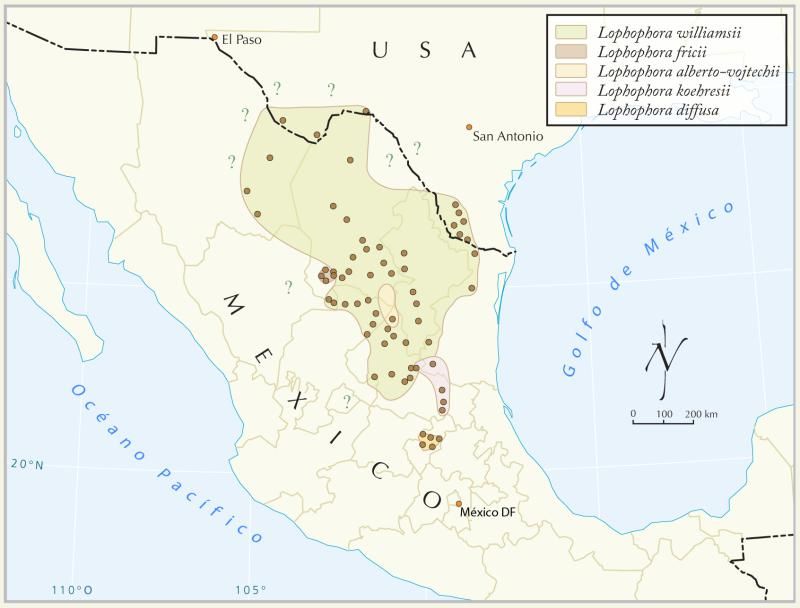
As long as we're posting maps, I figured I'd post this one.

Peyote locations.

:biggrin::biggrin::biggrin::biggrin:

OK, back on topic.....................


The Four Types of Deserts in the US??

Howard - 1-26-2015 at 06:49 PM

All this time I thought the four were:

Apple pie
Vanilla Ice Cream
Mud Pie
Berries and cream