TLBaja79 - 2-24-2015 at 08:48 PM
Does GAIA app work down in Baja?
I will have my US phone and would want to use it when we are way off the main road outside of any town.
Anybody used it?
I don't want to spend the $20 if it doesn't work down there.
gnukid - 2-25-2015 at 05:44 AM
Gaia app requires GPS which may depend on cell connection to phone towers. There is often a lack of cell service outside of cities. You could use
other GPS location tools to know where you are, but not using the cell phone app dependably.
TLBaja79 - 2-25-2015 at 09:05 AM
Ya that's what I was thinking, need to be near cell tower for it to work correctly...
jeffg - 2-25-2015 at 09:26 AM
You need to verify that the maps they offer include Baja, but other than that it should be functional. The GPS signal does not require cellular
service, it comes from the satellites. Assuming the maps are already downloaded and stored on your phone, it should work.
BooJumMan - 2-25-2015 at 10:05 AM
Looks like they cover baja.. https://www.gaiagps.com/map/#?lat=38.3417&lon=-98.0859&a...
David K - 2-25-2015 at 10:27 AM
Thanks for the link! Great topo map of Baja!
StuckSucks - 2-25-2015 at 12:33 PM
I've used the Gaia app several times while racing in Baja. I preload detailed sat maps of the area of where I'm going to be. The GPS function shows my
current location; the detailed sat maps help me navigate to remote locations (e.g. stuck, broken race car). For remote wandering, this is a helpful
app.
There's a boatload of different maps you can import, e.g. sat, topo, road, terrain, etc.
Also useful, is the ability to import tracks.
StuckSucks - 2-25-2015 at 01:54 PM
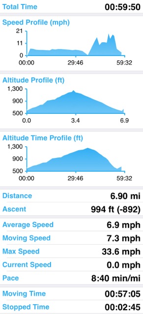
Hard core GIS data porn
Gaia will track and analyze your movement. Here's my stats riding my mountain bike up/down a canyon in the local mountains - up fireroad (not so
fast), down single track (faster).

And here's an elevation/speed profile of the same ride. The ride starts on the left, then progresses to the right. The first half is uphill, slower
riding, then the return trip with higher speeds. Click to embiggen.

Jack Swords - 2-25-2015 at 04:11 PM
And, in addition, Google Earth will work offline if locations and routes are preloaded, including elevations desired. Several gb are retained in
memory for use offline WITHOUT a cell connection. Gps must be activated in the device and will show your location with a colored dot. Backroads in
Baja show up clearly in GE.


