Another post that mentioned the Montevideo rock art site prompted me to remember this discussion that we had several months ago. I want to give it a
bump and add a few more comments.
I was in Las Vegas in April of this year and while I was there I took time to visit the Valley of Fire, including both of the rock art panels that I
offered interpretations for in this thread.
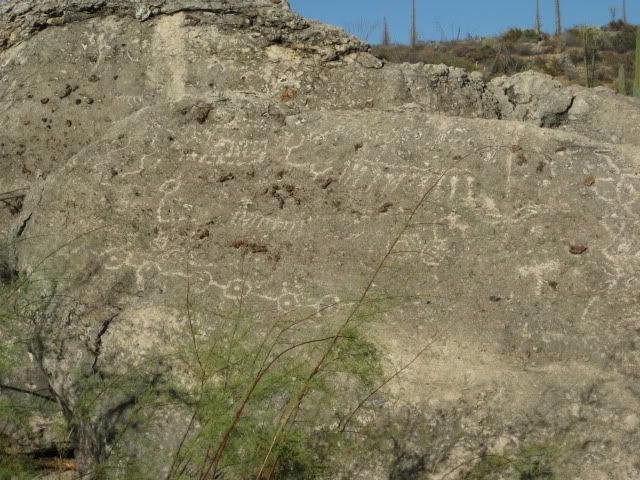
The second panel (the one I numbered from 1 to 73 above) turned out to be just a part of a MUCH larger panel. Right now that panel is one of the most
popular ones to view in the Valley of Fire and a nice staircase and viewing platform have been built right up to the panel, but the positioning of the
platform makes it natural for people to see and photograph the part of the panel that you see in my post above, but when you're there you'll find that
there is a LOT more to it than just that part that people tend to photograph.
The viewing platform actually sits in the way of a lot of the panel and obstructs the view enough that I had to take a lot of photos from a lot of
angles to try to capture it all. I haven't taken time to piece those photos together yet, nor have I tried to interpret the panel as a whole so I'll
refrain from elaborating on it before I do more work.
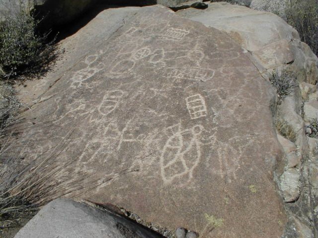
I do have some more comments about the first Valley of Fire panel that I attempted to interpret in this thread. Here it is again just so it's clear
which panel I'm referring to:

And here is an updated interpretation of the panel based on my earlier comments combined with my own observations at the site as well as replies from
Wilderone in this thread (Wilderone: please correct me if I misinterpreted your comments):
"Traveler(s) can't, and should be apprehensive about crossing a place that is deep and has high walls which is a long distance to the left, uphill, on
a path above the traveler(s), which leads to a river of water (this is referring to trying to cross the Colorado River near where Hoover Dam is now
located). Traveler(s) can't go around this river. Traveler(s) can't, and should be apprehensive about going above to the trail above the river
because it comes to a point that can't be passed. The trail above the river on the hill becomes rough. Traveler(s) can't travel across the canyon by
the river. No crossing exists. A trail across the canyon would lead to nothing. This is a long way from the good journey in the other direction.
The river can be avoided by traveling a short journey on an open trail over rough terrain to the right. Continue in this direction, but you'll be
descending into a canyon and even deeper - don't get too low into the canyon because you won't be able to continue and you'll have to backtrack to get
out. You're heading for, and look for, a certain place (Moapa Valley which is a good settlement and a good way to get across the tributaries to the
Colorado River). The path leads to shelter along this route."
(For a point-by-point description of this interpretation, see the earlier discussion in this thread)
After visiting the site I still think that the interpretation we discussed earlier this year is largely correct. In addition, when I visited the site
I saw that the interpretation of the right-facing quadrupeds by Wilderone was fantastically accurate:
"Continue in this direction, but you'll be descending into a canyon and even deeper - don't get too low into the canyon because you won't be able to
continue and you'll have to backtrack to get out. "
What caught me by surprise though was that I was wrong when I said:
Quote: Originally posted by elbeau  | | ...I haven't been able to ascertain the exact orientation of that panel yet, but I'm traveling to Vegas for my brother's wedding next month and I plan
on checking it out. I'll bet dollars to donuts that that panel is best viewed best viewed from the east looking west. |
After visiting the panel I can say that it was clearly meant to be viewed from the west looking east. This caught me by complete surprise...but on
the other hand, my original interpretation of the symbols (before comparing it to the birds-eye-view in Google Earth) was still correct. When viewing
the panel from the west looking east, the path to the "bad crossing" is still "a long distance to the left" and the "easier journey" leading to Moapa
Valley is still "to the right" like I originally interpreted it.
The mistake I made happened after I interpreted what was actually written in the panel and compared it with Google Earth. Doing so validated one
aspect of my interpretation (it showed that the line shown as #21 was a highly-accurate trace of the path of the Colorado River), but it also led me
to think that the quadruped symbols could be interpreted as birds-eye directions rather than pathway directions.
In other words, if a person viewing the panel traveled "left" from there, they would not immediately be traveling in a compass line towards the
crossing. Instead, traveling "left" simply puts them on the correct trail, which starts by going northward from the panel following the course of the
wash where the panel is located, then it follows a slow, but general curve to the left (represented by #24 in the photo) to the "bad crossing" point.
The course of this path matches the rest of the panel very well and shows me that I need to be careful about not letting my own paradigms regarding
directions cloud my judgement about what is written in these panels.
Here's an intriguing lesson from this panel that may be more broadly applicable: Quadrupeds do NOT represent compass directions, and they don't even
point towards an anticipated destination. They ONLY represent the direction of travel along the path from the viewpoint of a person reading the
panel. In other words, they are not "map" indicators. They are telling someone to go right, left, forward, or backward --FROM THAT SPOT-- and do NOT
indicate the direction of any final destination in respect to the panel.
On the other hand, the curved line in #21 matches the course of the Colorado River far too accurately for me to think it's just a coincidence:

^Note in that image the big loop the river takes to the left and back. That can't be seen in Google Earth because Lake Mead now covers it, but I
looked into it and found a map showing that the Colorado River actually followed that exact path before Hoover Dam was built.
This means that although the quadrupeds don't represent map-like directions, the concept of a birds-eye map did exist in the writing system. It just
shouldn't be confused with the "path" directions indicated by quadrupeds.
In other words, if my interpretation of this panel can be applied more broadly (which I really don't know yet), then it means that when an author
wanted to indicate birds-eye directions, they traced lines (like #'s 21 and 24) but when they wanted to indicate "relative" directions like "left",
"right", "forward", or "backward" that specifically related to trails or journeys, they used quadrupeds.
I also want to point out another change that I made to the interpretation. In the interpretation I gave above in this reply today, I replaced the
phrase "a short, good journey to the right" with the phrase "a short journey on an open trail over rough terrain to the right". There are two reasons
I made this change. First, the quadrupeds representing the various parts of this journey are VERY thickly pecked, indicating rough terrain. Second,
when you visit the site you will see exactly why the author described the trail that way. The journey on the path to the right of the panel starts by
going is through some fantastically beautiful rock formations. The wash you travel along is sometimes easy to traverse, but sometimes it's hard.
Also, like I mentioned before, Wilderone was right when he noticed the warning the author made about going too far down the canyon on the journey to
the right. Doing so would take you deep into large, terribly winding rock formations and if you went that way you would end up needing to backtrack
just like Wilderone said in order to get to Moapa Valley. The short, rougher path is the right way to go rather than descending all the way down the
easy-to-travel sand bed of the wash into the rock formations.
To sum up, the panel warns of a bad journey to nowhere if you take the high-road to the left. It tells you that a good place can be found by going to
your right, but it warns you not to descend deep into the winding rock-formations as you go to the right. Instead, stick to the open trail that leads
over rough terrain in order to reach Moapa Valley. |


