BajaNomad

Tis the season - Dual Hurricanes: Andres & Blanca

 Pages:  1    3

woody with a view - 5-23-2015 at 11:28 AM

To start watching the happenings downstream! It looks like the models are getting a grip on the first EPAC storm of the year. This model is updated every 6 hours and anyone who knows anything about climate change, I mean weather, knows it can change quickly! As of now, there is a storm forecast at the very end of the loop.

Look out below!

http://www.stormsurfing.com/cgi/display.cgi?a=npac_height


[Edited on 5-23-2015 by woody with a view]

[Edited on 6-2-2015 by BajaNomad]

55steve - 5-23-2015 at 12:24 PM

I'm ready for an exciting year - storms, surf & off the scale fishing!

Udo - 5-23-2015 at 12:54 PM

Specially the fishin!

55steve - 5-23-2015 at 03:08 PM

Quote: Originally posted by Udo  
Specially the fishin!


Of course! YFT, yellowtail and BFT are already biting locally. The yellowtail never really slowed down all winter and a friend was out off La Jolla today killing great sized (20-30 lbs) ones!

woody with a view - 5-24-2015 at 11:28 AM

looks like a spinner! first one of the season, and early!

woody with a view - 5-25-2015 at 08:45 AM

why not start the year off with a BANG!

http://www.stormsurfing.com/cgi/display.cgi?a=npac_height

[Edited on 5-25-2015 by woody with a view]

CaboDreamer - 5-26-2015 at 10:06 AM

Here is another model that tends to be somewhat accurate...

http://magicseaweed.com/Mexico-Pacific-MSW-Surf-Charts/19/?c...

torch - 5-26-2015 at 02:26 PM

hmm might have a change of plans if this plans and put off my trip a week. I do love that storm model.

mtgoat666 - 5-26-2015 at 04:40 PM

all this talk about models and predictions by govt scientists,... a pack of lies! the words of charlatans! don't believe it one bit!

Russ - 5-26-2015 at 04:53 PM

Don't get too excited. These are way NW of where the usual storms develop. I trust eebmike.com for my forecast info this time of year. Hard to argue with in motion sat loops.


[Edited on 5-26-2015 by Russ]

chippy - 5-26-2015 at 05:23 PM

X 1 should be the first named storm of the season?

Meany - 5-26-2015 at 08:02 PM

It's out there and comeing are way. All in good time.:bounce:

Pompano - 5-26-2015 at 08:13 PM

Well, for sure it won't be named Isis or Odie.

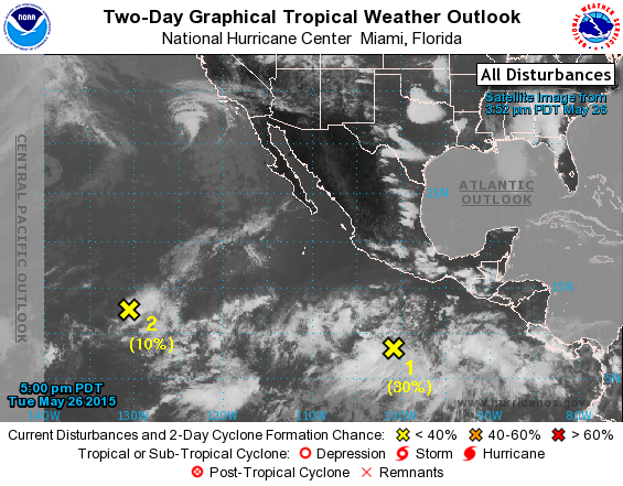
RED X

chuckie - 5-27-2015 at 11:30 AM

National Hurricane Center has its first? RED X South of Baja at 90%, and it aint June yet.....

Udo - 5-27-2015 at 01:42 PM

Woopie!:biggrin:

StuckSucks - 5-27-2015 at 01:44 PM

TROPICAL WEATHER OUTLOOK
NWS NATIONAL HURRICANE CENTER MIAMI FL
1100 AM PDT WED MAY 27 2015

For the eastern North Pacific...east of 140 degrees west longitude:

Showers and thunderstorms associated with an area of low pressure
located about 800 miles south-southwest of Manzanillo, Mexico,
continue to show signs of organization. Environmental conditions
are conducive for development and this system is likely to
become a tropical depression during the next day or so while it
moves west-northwestward at 10 to 15 mph.
* Formation chance through 48 hours...high...80 percent
* Formation chance through 5 days...high...90 percent

Shower activity remains limited in association with a weak area of
low pressure located about 1550 miles west-southwest of the southern
tip of Baja California. Environmental conditions are expected to
remain unfavorable and development of this system is not
anticipated.
* Formation chance through 48 hours...low...near 0 percent
* Formation chance through 5 days...low...near 0 percent

vandenberg - 5-27-2015 at 01:59 PM

Get your hurricane shutters and security blankets out.

:P:biggrin::biggrin:

Bob and Susan - 5-27-2015 at 02:52 PM

weather is great today!!!
90f with a 3mph breeze
at night it's about 70f
pool is 80f

I sent "the boys" out on Monday with a guide...a pretty good day
the fish died by the boat...we ate him yesterday for lunch
actually marlin is really good...I was surprised

some of you guys from the north leave way too early

may2015.jpg - 169kB

cliffh - 5-27-2015 at 02:57 PM

1st one last year Amanda may22

blackwolfmt - 5-27-2015 at 03:36 PM

http://www.ssd.noaa.gov/goes/west/epac/flash-rb.html

bajabuddha - 5-27-2015 at 03:57 PM

El Niño strikes again; warmer-than-usual water = all-bets-are-off for east cape and Baja Sur..... again. Be wise, stock up now.

chippy - 5-27-2015 at 04:47 PM

http://www.nhc.noaa.gov/gtwo.php?basin=epac&fdays=2

They are stacking up:bounce::bounce:

chippy - 5-27-2015 at 04:50 PM

http://www.nhc.noaa.gov/gtwo.php?basin=epac&fdays=2

I´m still betting on numero uno!

Bajahowodd - 5-27-2015 at 04:56 PM

Quote: Originally posted by bajabuddha  
El Niño strikes again; warmer-than-usual water = all-bets-are-off for east cape and Baja Sur..... again. Be wise, stock up now.


But, for California alta, maybe an El Nino event will be a godsend.

blackwolfmt - 5-27-2015 at 05:36 PM

Quote: Originally posted by Bajahowodd  
Quote: Originally posted by bajabuddha  
El Niño strikes again; warmer-than-usual water = all-bets-are-off for east cape and Baja Sur..... again. Be wise, stock up now.


But, for California alta, maybe an El Nino event will be a godsend.


Heck yeah fill up all them back yard pools

bajacamper - 5-27-2015 at 06:36 PM

Drive up Hiway 5 from Bakersfield to Modesto. It has to do with bare, dry, fallow ground. Not a swimming pool in sight.

chippy - 5-28-2015 at 10:58 AM

TS Andres!!!!!!

chuckie - 5-28-2015 at 12:59 PM

It is now Tropical storm "Andres", been up graded.....And another one in the making right behind it.....

chuckie - 5-29-2015 at 02:02 AM

Andres will be a hurricane today.....

elgatoloco - 5-30-2015 at 09:11 PM

Hurricane Andres

http://www.surfline.com/surf-news/hurricane-andres-surf-outl...


durrelllrobert - 5-31-2015 at 08:54 AM

Quote: Originally posted by mtgoat666  
all this talk about models and predictions by govt scientists,... a pack of lies! the words of charlatans! don't believe it one bit!

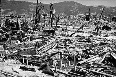
Real Government scientist don't lie because they aren't allowed to disclose what they are doing to the public. Did they inform us about the A-bomb development before the first one was dropped on Hiroshima?


tiotomasbcs - 5-31-2015 at 12:07 PM

Surfs Up! Solid 6ft swell with closely stacked waves lining up offshore and pounding the beaches. South facing points must be firing! Think I'll head out to... Looks like Numero dos is right behind Andres. Yesterday was very warm --almost tropical. Tio

shari - 5-31-2015 at 12:56 PM

the swell is starting to build here on the central Pacside in Asuncion...tomorrow will be thundering! Summer like days...even got the pool filled...in MAY! crazy chit

Bajaboy - 5-31-2015 at 01:42 PM

Quote: Originally posted by shari  
the swell is starting to build here on the central Pacside in Asuncion...tomorrow will be thundering! Summer like days...even got the pool filled...in MAY! crazy chit


Just need the water to warm up now.

OH OH...another "storm" comin ! - Hurricane Andres

cj5orion - 6-1-2015 at 06:30 AM

Jus forming up now,not even a TS yet...but

sailflow's forecast shows it just scraping Southern Baja Saturday,,,looks like a full "cane" at that point !

http://sailflow.com/en-us/Search/ViewResults.aspx#22.843,-11...

[Edited on 6-1-2015 by BajaNomad]

YIKES !!

captkw - 6-1-2015 at 06:43 AM

Those ufo folks have been a'warning us that we have been screwing up this chunk of spinning molten rock fast...crazy,,crazy weather to say the least !! Hang on to your hats,,I think in the next year we will ALL see some crazy stuff weatherwise!!!

Hook - 6-1-2015 at 07:29 AM

Interesting historicaly discussion by Dr. Jeff Masters this AM about H. Andres....

Hurricane Andres became only the fifth major May hurricane on record in the Northeast Pacific on Sunday, when it intensified into a 125 mph Category 3 storm in the waters about 800 miles southwest of the tip of Mexico's Baja Peninsula. Its unexpected intensification continued Sunday evening, with Andres reaching Category 4 strength with 140 mph winds at 11 pm EDT. According to the database of Eastern Pacific storms maintained by NOAA's Office for Coastal Management, Andres' emergence as a major hurricane at longitude 118.8°W marks the farthest west a major hurricane has been in the Northeast Pacific in May in the 45 years since accurate satellite records began in 1970, and comes well before the usual July 19 formation date of the first major hurricane of the Northeast Pacific hurricane season. This unusually early and far westerly intensification was made possible, in part, by sea surface temperatures (SSTs) that are very warm, at least 2°F (1.1°C) above average--thanks in large part to the intensifying moderate-strength El Niño event underway in the Eastern Pacific. The other May major hurricanes were Adolph (2001), Alma (2002), Bud (2012), and Amanda (2014). The strongest was Hurricane Amanda, which peaked as a top-end Category 4 hurricane with 155 mph winds on May 25, 2014. The earliest Category 5 storm on record in the Eastern Pacific was Hurricane Ava of 1973, which peaked at 160 mph winds on June 6, 1973. Both years (2014 and 1973) had ocean temperatures that were unusually warm along the path of these intense hurricanes: at least 0.4°C above average. Andres will stay well out to sea and not affect any land areas.


danaeb - 6-1-2015 at 08:31 AM

Baja has another "Blanca".

Five day forecast:

http://www.wunderground.com/hurricane/east-pacific/2015/trop...

SFandH - 6-1-2015 at 09:21 AM

Quote: Originally posted by captkw  
Those ufo folks have been a'warning us that we have been screwing up this chunk of spinning molten rock fast...crazy,,crazy weather to say the least !! Hang on to your hats,,I think in the next year we will ALL see some crazy stuff weatherwise!!!


http://en.wikipedia.org/wiki/2015_Pacific_hurricane_season

"On April 10, 2015, the Servicio Meteorológico Nacional (SMN) issued its first outlook for the Pacific hurricane season, forecasting 19 named storms, 11 hurricanes, and 4 major hurricanes. The organization listed a set of seasons with similar atmospheric and oceanic conditions, including 1982, 1986, 1991, 1994, 2003, and 2014.[3] On May 27, the National Oceanic and Atmospheric Administration's Climate Prediction Center (CPC) released its forecast for the year, highlighting a 70% chance of an above-average season with 15–22 named storms, 7–12 hurricanes, 5–8 major hurricanes, and an Accumulated Cyclone Energy (ACE) index range of 110–190% of the median. While both organizations cited an intensifying El Niño as a result of increased activity, the CPC also highlighted the difference in global sea surface temperature patterns in 2015 versus the 1995–2014 period.[3][4]"

It will be interesting to see how accurate the predictions are.

StuckSucks - 6-1-2015 at 12:37 PM

Depending upon the model you look at, the remnants of Andres MAY hit northern Baja/SoCal this coming weekend with either a little rain or torrential rains. IF the heavens open up, that could make for an interesting Baja 500.

That said, I'm bringing an EZ-Up to keep the sun off my head.

Mexitron - 6-1-2015 at 01:14 PM

Quote: Originally posted by StuckSucks  
Depending upon the model you look at, the remnants of Andres MAY hit northern Baja/SoCal this coming weekend with either a little rain or torrential rains. IF the heavens open up, that could make for an interesting Baja 500.

That said, I'm bringing an EZ-Up to keep the sun off my head.


And that would add even more precip to the a'MAY'zing May rains in socal...

chuckie - 6-1-2015 at 01:21 PM

Blanca......

BajaNomad - 6-1-2015 at 01:34 PM

http://www.wunderground.com/hurricane/eastern-pacific/2015/H...

bajabuddha - 6-1-2015 at 03:37 PM

https://www.windyty.com/?2015-06-01-06,33.833,-111.951,4

Andres is visible quite plainly SW of Baja. HOWEVER: hit the 'show actual forecast' button in the bottom right corner and then 'play'... let it run; watch the current development just off the mainland, and see what happens by Monday......

This is just a computer simulation of 'maybe's and what-ifs', but, once again, if I were in Los Cabos or Todos Santos I'd have my bottled water and generator ready. This is only the beginning.

Buena Suerte a todos.

[Edited on 6-1-2015 by bajabuddha]

Whale-ista - 6-1-2015 at 03:46 PM

I'm in San Diego- Please keep the wind. Send the rain...

I recall winter time El Niño storms in the mid-80s- Cali got the rain, Baja got the wind, maybe a little rain- pushed out of the NW.

This winter we had wind out of the south, and a few days of thunder/lightning in February, +heavy rain, flooding in Vizcaino/GN area... the year was off to a strange start months ago.

Who knows where it will go from here...

Quote: Originally posted by Bajahowodd  
Quote: Originally posted by bajabuddha  
El Niño strikes again; warmer-than-usual water = all-bets-are-off for east cape and Baja Sur..... again. Be wise, stock up now.


But, for California alta, maybe an El Nino event will be a godsend.

DavidT - 6-1-2015 at 08:35 PM

Andres

4Cata - 6-1-2015 at 09:23 PM

So, this storm will be named Caramba???

bajabuddha - 6-1-2015 at 10:34 PM

Quote: Originally posted by 4Cata  
So, this storm will be named Caramba???


Just wait until "Holy SheeIt!!"

cj5orion - 6-2-2015 at 04:17 AM

http://sailflow.com/en-us/Search/ViewResults.aspx#20,-110.68...

cj5orion - 6-2-2015 at 06:51 AM

http://sailflow.com/en-us/Search/ViewResults.aspx#20,-110.68...

chuckie - 6-2-2015 at 07:45 AM

Blanca....


BajaNomad - 6-2-2015 at 03:39 PM

Quote: Originally posted by chuckie  
Blanca....


http://www.wunderground.com/hurricane/eastern-pacific/2015/H...

chuckie - 6-2-2015 at 03:48 PM

Made the big time news...CNN....Don't expect anyone here to pay any attention tho....Grab another Pacifico and slide back into denial.....Wont hit MY house, Nah....Today is JUNE 2ND folks....

bajabuddha - 6-2-2015 at 03:54 PM

HERE THEY ARE, FOLKS! Your visitors for 2015:

Andres (currently active)
Blanca (currently active)
Carlos (unused)
Dolores (unused)
Enrique (unused)
Felicia (unused)
Guillermo (unused)
Hilda (unused)
Ignacio (unused)
Jimena (unused)
Kevin (unused)
Linda (unused)
Marty (unused)
Nora (unused)
Olaf (unused)
Patricia (unused)
Rick (unused)
Sandra (unused)
Terry (unused)
Vivian (unused)
Waldo (unused)
Xina (unused)
York (unused)
Zelda (unused)

http://en.wikipedia.org/wiki/2015_Pacific_hurricane_season#S...


[Edited on 6-2-2015 by bajabuddha]

Bob and Susan - 6-2-2015 at 03:55 PM

https://www.windyty.com/?clouds,2015-06-07-06,23.262,-108.12...

click over to sat sunday...wow

El Jefe - 6-2-2015 at 04:25 PM

We are taking Blanca seriously on the near-east cape. Everybody is talking about it. The trash man, the gas man, the builder next door, all are asking is there a storm really coming? Everyone is a little gun shy after Odiel last year.

I have never seen 30 foot waves predicted for our area like they are for Saturday. Quite a ways out of my league for sure, and since the wind will be howling I'm sure I will enjoy the show from the deck.

This is entirely too early in the year to have to button up the house and batten down the hatches! But as things stand now, looks like we will have to.

Have neighbors planning to fly out of Los Cabos Sunday. Good luck with that! Sure hope this thing heads west.


Russ - 6-2-2015 at 06:38 PM


Blanca

4Cata - 6-3-2015 at 12:17 AM

The taste of marlin is great, BUT the amount of mercury in them has sent me to emergency twice, so enjoy my share of marlin, though I wouldnt mind catching one.

chuckie - 6-3-2015 at 01:46 AM

Best to hang em by the BILL for a while in a cool place, letting the mercury accumulate in the tail portion. Then discard about a foot of the tail before eating. Or take that section to a refiner, often there is enough the price will pay for fuel.

chuckie - 6-3-2015 at 02:11 AM

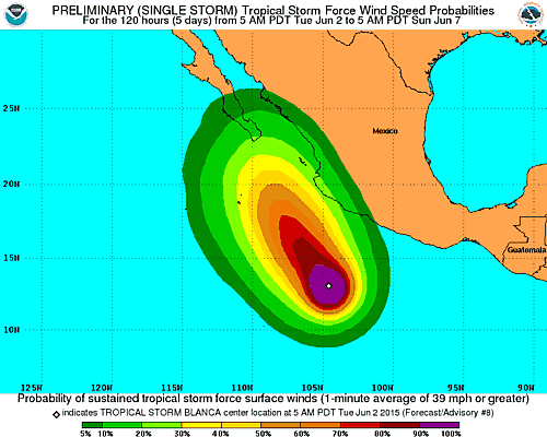
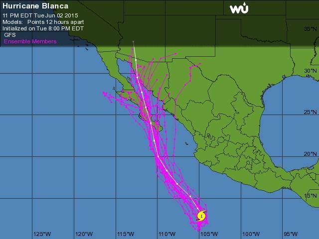
Blanca Path....pretty consistent....


Bob and Susan - 6-3-2015 at 04:47 AM

"prepare for punishment"

Russ - 6-3-2015 at 05:39 AM

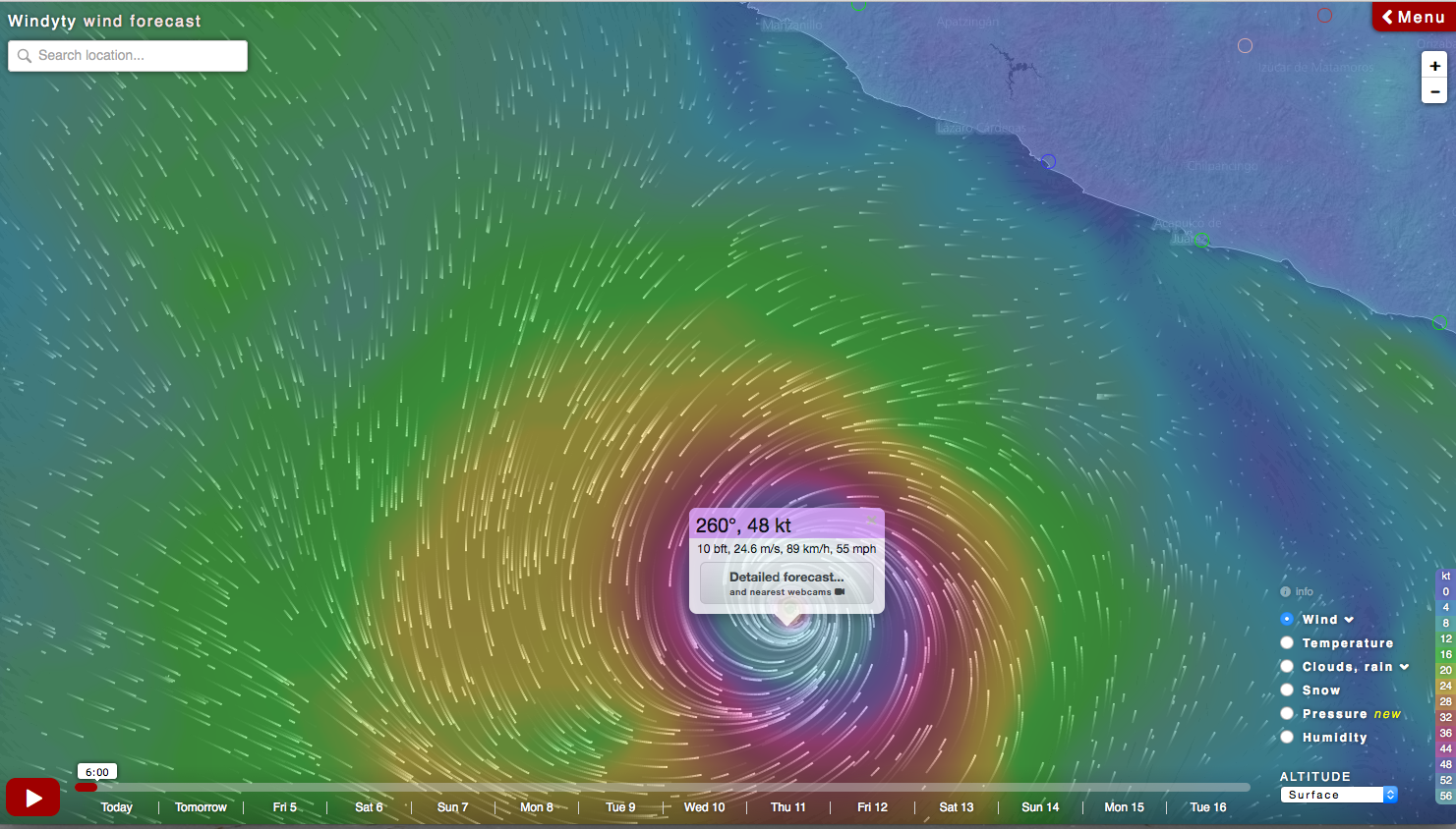
https://www.windyty.com/?14.897,-105.051,7


Forecast -- Sunday at noon


[Edited on 6-3-2015 by Russ]

cj5orion - 6-3-2015 at 06:26 AM

#3 forming up ?????

https://www.windyty.com/?2015-06-09-12,12.983,-103.579,5

shari - 6-3-2015 at 07:47 AM

OH geeze...it's gonna be a loooooong summer amigos! Amazing we are experiencing shades of last September in early June! tick tick tick tick

Hook - 6-3-2015 at 12:49 PM

Blanca predicted to be a Cat 5 hurricane within 24 hours?

Apparently, it's already Cat 4.

BajaNomad - 6-3-2015 at 01:01 PM

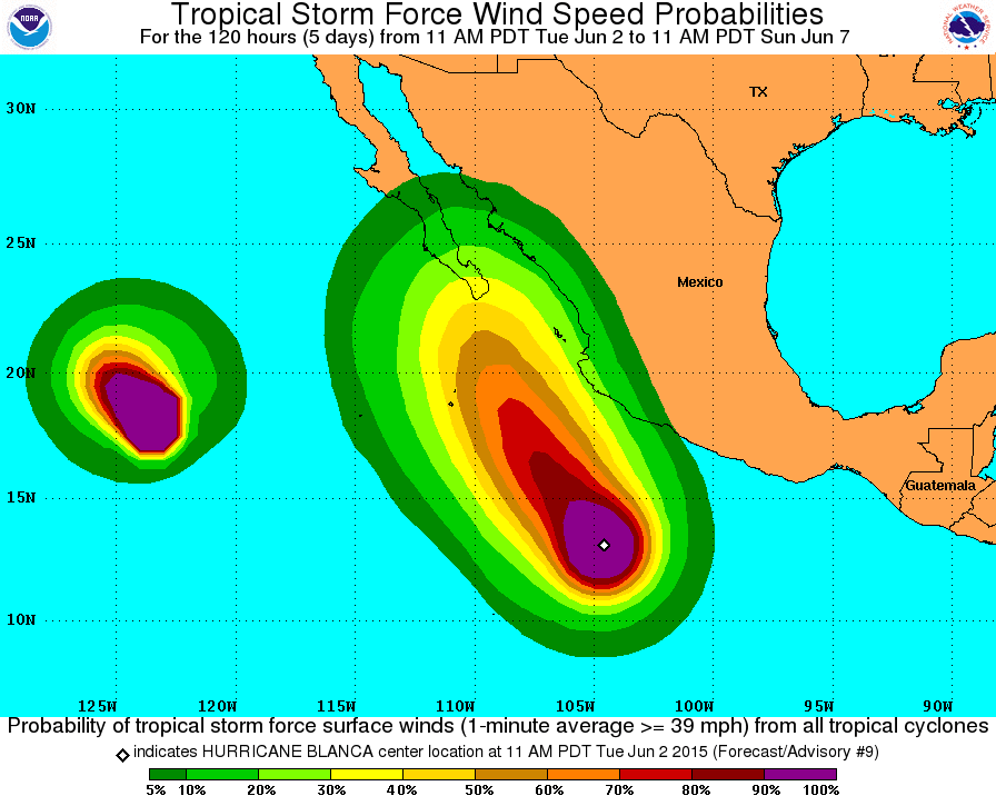
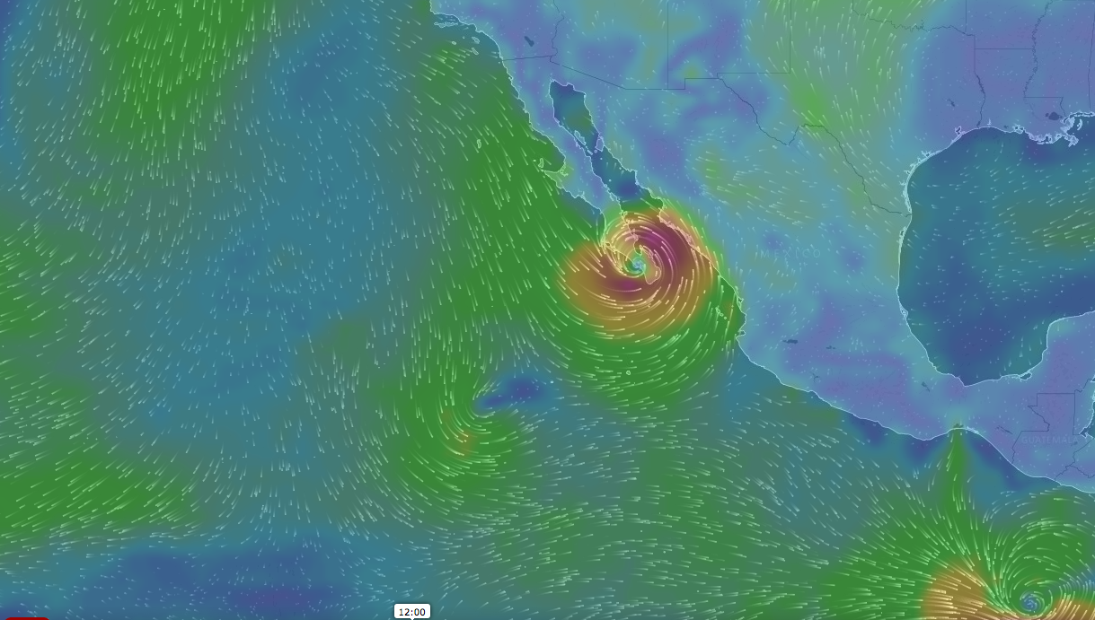
Visual forecast...

150603-1p-dual-hurricanes.jpg - 72kB

SFandH - 6-3-2015 at 03:49 PM

Here's an interesting weather web page. It has a collection of maps and satellite images that are pertinent to Baja California. Loads fast, at least on my computer.

The first image is Andreas. Scroll down a bit for Blanca

http://eebmike.com/

and another I like:

http://earth.nullschool.net/#current/wind/surface/level/orth...


[Edited on 6-3-2015 by SFandH]

shari - 6-3-2015 at 07:48 PM

late this afternoon, the outer bands started drifting in from Hurricane Andres who passed us by thank goodness...some pretty dark clouds offshore.

Hook - 6-4-2015 at 06:14 AM

Blanca has begun a weakening process and watchers are unsure of the cause. But she has been downgraded to a Cat 3, without ever having approached Cat 5 status.

MOST models are now showing a more westerly course that would avoid a direct impact on Cabo. This would also take it over cooler water much faster. But one still shows a pretty direct hit and one actually has it entering the Sea without making land, only to hit the mainland somewhere near Topolobampo.

http://www.wunderground.com/hurricane/eastern-pacific/2015/H...


[Edited on 6-4-2015 by Hook]

Hook - 6-4-2015 at 06:18 AM

Quote: Originally posted by shari  
late this afternoon, the outer bands started drifting in from Hurricane Andres who passed us by thank goodness...some pretty dark clouds offshore.


After a real scorcher of a day (~100F) over here, yesterday, that saw the relative humidity drop 60% in a few hours, we are seeing some of the remnant moisture from Andres, as well.

Russ - 6-4-2015 at 06:35 AM

I like this model better. Track moving more West and decreasing in strength

US consulate TJ) warning posted on Talk Baja

rts551 - 6-4-2015 at 12:24 PM

Emergency Message: Hurricane Blanca
Baja California Sur
Important information for US Citizens in Baja California Sur
June 4, 2015

This emergency message informs U.S. citizens that the National Hurricane Center (NHC) and Mexican authorities are projecting that Hurricane Blanca will likely make landfall in Baja California Sur in the coming days. Currently a Category 4 hurricane, Blanca is expected to strengthen a bit more before weakening just prior to making landfall. However, even as a Category 1 hurricane or significant Tropical Storm, strong winds, rains, and tides (including rip currents and rogue waves) will impact the southern Baja California peninsula, including Los Cabos. Current projections indicate that Blanca will most likely hit just north of the Los Cabos area on Monday morning, but the effects of the storm will be felt throughout the state of Baja California Sur.

Bajahowodd - 6-4-2015 at 04:53 PM

Inasmuch as this is an unprecedented storm as far as the date, I challenge climate change deniers to explain this.

chuckie - 6-4-2015 at 05:20 PM

WHY? This is about Blanca, not climate change....

wessongroup - 6-4-2015 at 05:23 PM

We'll see ... :lol::lol:

chuckie - 6-4-2015 at 05:27 PM

Yeah I know, we'll be listening to dissertations from guys like Wodd on dunkin donuts next.....

tiotomasbcs - 6-4-2015 at 07:24 PM

Looks like most of us in BCS will get some rain! Let's hope for light winds and that Blanca doesn't stall out over the mtns anywhere. Waiting game now. Cheers! Tio

Hook - 6-4-2015 at 07:31 PM

Well, depending on the time this was issued, they could at least be a little more up to date.

Blanca will be lucky to be a Cat 1, when it is still 100 miles south of Cabo.

Blanca is beginning to look like much-ado event, if you are prepared for some rain.

chippy - 6-4-2015 at 07:36 PM

The interesting thing about Blanca is it will move alot of warm water north very early in the season. We will see how that plays out.:light:

Meany - 6-4-2015 at 07:46 PM

May be Bri:bounce::bounce:ng up some Tuna or some thing???

shari - 6-4-2015 at 07:53 PM

the net fishermen here are reporting some sporadic tuna already just a few miles off Asuncion where there is warmer water...dont write Blanca off yet, she could surprise you!...er us! Either way it looks like heavy rain here on Monday...gettin my sand bags ready.

BajaNomad - 6-4-2015 at 08:26 PM


150604-824p.jpg - 113kB

Blanca was downgraded to Category 2 today but...

Whale-ista - 6-4-2015 at 09:21 PM

Blanca now Category 4, heading for Baja

Blanca was just a tropical storm on Monday but now it threatens to become a Category 5 hurricane by tomorrow, and it’s heading for Baja California Sur.

Forecasters say that if it does make landfall in Baja it will do so some time on Sunday but will have weakened considerably by then. However, residents of Los Cabos and the southern part of the peninsula are being advised to monitor the storm’s progress.

Blanca has strengthened quickly since it formed Monday, becoming a Category 1 hurricane yesterday morning and intensifying rapidly since, becoming a major hurricane, Category 4, this morning.

The Weather Channel said it could reach Category 5 by tomorrow.

As of 10:00am central time it was stationary, sitting 675 kilometers south-southwest of Zihuatanejo, Guerrero, and 735 kilometers south of Manzanillo, Colima. Maximum sustained winds were 215 km/h.

No coastal warnings are in effect but swells will begin to be seen over the next two days, said the U.S. National Hurricane Center (NHC).

The storm is expected to strengthen further in the next 48 hours and begin to move northwest during the next 24. Since it represents a potential threat to the Baja peninsula, a reconnaissance aircraft is expected to investigate the storm on Friday.

The National Meteorological Service warns that very heavy rain can be expected in Jalisco, Michoacán and Guerrero along with electrical storms, hail and strong winds.

Blanca is the earliest second major hurricane to form in the eastern north Pacific since 1971, said the NHC.

It was only eight months ago that Los Cabos was hit by Hurricane Odile, destroying as many as 8,000 homes and businesses and stranding thousands of tourists. Fifteen people died during the storm’s six-day course and damages were estimated at 16 billion pesos.

UPDATE Thursday, June 4: Blanca was downgraded to Category 2 today but the NHC said at 4:00pm Central Time that it could gain strength over the next 24 to 36 hours. It is expected to deliver rain and wind to Baja California Sur, where it should make landfall Saturday night or Sunday morning. It was reported to be situated 695 kilometers south of Manzanillo, Colima, and 1,225 kilometers south-southeast of Cabo San Lucas, BCS, this afternoon.

Mexico News Daily

wessongroup - 6-4-2015 at 09:33 PM

Hang on ...

Russ - 6-5-2015 at 05:01 AM

Not so nice forecast

cj5orion - 6-5-2015 at 05:17 AM

Sailflow is now forecasting... !!


Blanca stalls out jus BEFORE landfall !!!


Russ - 6-5-2015 at 06:23 AM

Even as a storm it can drop a lot of water and cause major flooding.

chuckie - 6-5-2015 at 06:33 AM

Yes, people don't remember that most of the major floods in Mulege were caused by rain from Hurricanes which did not pass directly over the area, Odile being an exception....ITS THE RAIN! NHC says that Blanca is strengthening this morning......

Hook - 6-5-2015 at 07:12 AM

No way it ever becomes anything but a Cat 2-3, and that will be short-lived. I see TS category IF it even makes Baja. Poor environment, dead ahead, for Blanca.

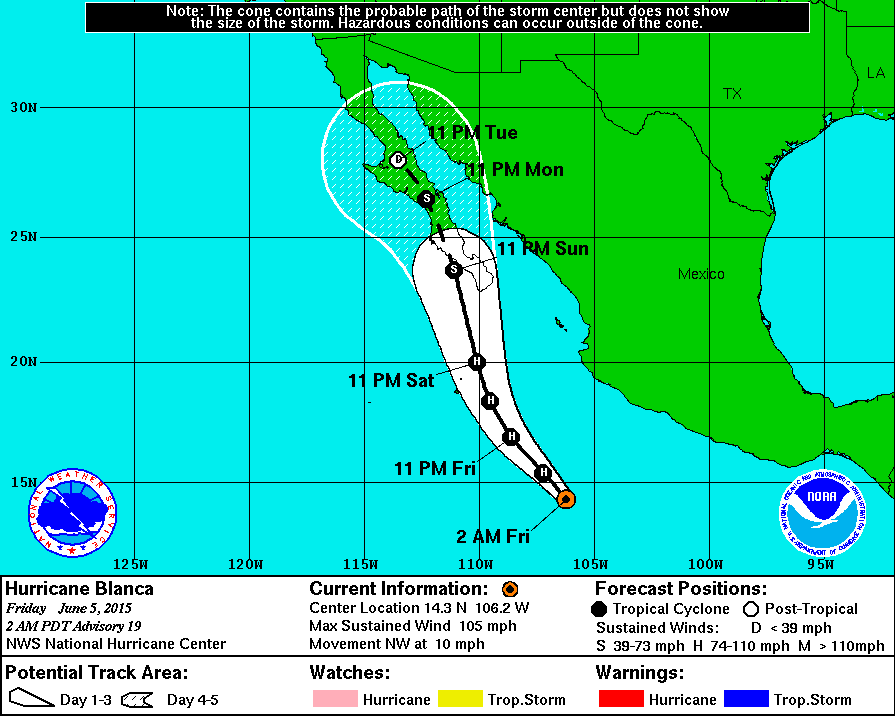
BajaNomad - 6-5-2015 at 08:02 AM


150605-800a.jpg - 76kB

DaliDali - 6-5-2015 at 08:51 AM

Quote: Originally posted by Hook  
No way it ever becomes anything but a Cat 2-3, and that will be short-lived. I see TS category IF it even makes Baja. Poor environment, dead ahead, for Blanca.


Every track forecast takes Blanca right over the top of Baja.
There is little doubt Blanca WILL make it to Baja...
The only question still yet to be determined is at what strength.
TS or tropical depression.
Either or, a TS and TD are prolific rain producing phenoms of nature and can take days to unwind.

TS or TD.......Baja will get very wet in the coming days.


NOAA link

Whale-ista - 6-5-2015 at 10:31 AM

Satellite image of Blanca heading towards Baja
http://t.co/ieYOpac0J4

Bajahowodd - 6-5-2015 at 04:49 PM

Quote: Originally posted by chuckie  
Yeah I know, we'll be listening to dissertations from guys like Wodd on dunkin donuts next.....


Go to your room! And leave me alone. Fixation??:?::?:

Whale-ista - 6-5-2015 at 09:14 PM

Interesting NOAA storm animated images here

Directory: http://www.ssd.noaa.gov/goes/west/tpac/

Colorful!

http://www.ssd.noaa.gov/goes/west/tpac/jsl-animated.gif

bajabuddha - 6-5-2015 at 09:33 PM

Quote: Originally posted by Bajahowodd  
Quote: Originally posted by chuckie  
Yeah I know, we'll be listening to dissertations from guys like Wodd on dunkin donuts next.....


Go to your room! And leave me alone. Fixation??:?::?:

Howie, the only fixation is you on yourself.

Go to YOUR room, and leave the rest of us alone. :P

bajabuddha - 6-5-2015 at 09:46 PM

PREACHIN' TO THE CHOIR....

Those in the central-BCS area, especially Mulege, if 'twere me i'd be getting my stuff to higher ground. Regardless of status, WATER IS COMING. You have a few days. Also, as learned last year, please get your commissaries stocked and fuel stored.

Be safe, be prepared. Those of us not there, but who have been there are with you and your families.

BajaNomad - 6-5-2015 at 10:23 PM

HURRICANE BLANCA ADVISORY NUMBER 22
900 PM MDT FRI JUN 05 2015

...BLANCA STRENGTHENS A LITTLE...
...TROPICAL STORM CONDITIONS POSSIBLE IN SOUTHERN BAJA CALIFORNIA
SUR ON SUNDAY...


SUMMARY OF 900 PM MDT...0300 UTC...INFORMATION
----------------------------------------------
LOCATION...16.1N 108.3W
ABOUT 330 MI...530 KM SW OF MANZANILLO MEXICO
ABOUT 480 MI...775 KM SSE OF CABO SAN LUCAS MEXICO
MAXIMUM SUSTAINED WINDS...100 MPH...155 KM/H
PRESENT MOVEMENT...NW OR 315 DEGREES AT 10 MPH...17 KM/H
MINIMUM CENTRAL PRESSURE...971 MB...28.68 INCHES


DISCUSSION AND 48-HOUR OUTLOOK
------------------------------
At 900 PM MDT (0300 UTC), the eye of Hurricane Blanca was located
near latitude 16.1 North, longitude 108.3 West. Blanca is moving
toward the northwest near 10 mph (17 km/h), and this motion is
expected to continue through Saturday. A turn toward the north-
northwest is forecast by Saturday evening. On the forecast track,
the center of Blanca will approach the southern Baja California
peninsula on Sunday.

Satellite images indicate that maximum sustained winds have
increased to near 100 mph (155 km/h) with higher gusts. No
significant change in strength is expected through Saturday.
Weakening is forecast Saturday night and Sunday, and Blanca should
weaken to a tropical storm as it approaches the southern Baja
California peninsula.

Hurricane force winds extend outward up to 45 miles (75 km) from the
center, and tropical storm force winds extend outward up to 195
miles (315 km).

The estimated minimum central pressure is 971 mb (28.68 inches).


HAZARDS AFFECTING LAND
----------------------
WIND: Tropical storm conditions are possible within the watch area
by Sunday morning.

SURF: Swells generated by Blanca are affecting the coast of
southwestern Mexico, the Pacific coast of the Baja California
peninsula, and the southern Gulf of California. These swells are
likely to cause life-threatening surf and rip current conditions.


HURRICANE BLANCA DISCUSSION NUMBER 22
900 PM MDT FRI JUN 05 2015

Blanca appears to have become a little better organized during the
past few hours. The eye does not look quite as ragged although it
is becoming more cloud filled. Deep convection is doing a better
job of wrapping around the eye, but there is still some asymmetry
with very intense convection occurring within the southeastern
quadrant. As a result, Dvorak estimates have risen to T5.5/102 kt
from TAFB and T5.0/90 kt from SAB. However, since the Hurricane
Hunters found Blanca's intensity to be on the low end of the earlier
satellite estimates, the maximum winds are conservatively raised to
85 kt on this advisory.

The initial motion remains northwestward, or 315/9 kt. Mid-level
high pressure over northern Mexico should keep Blanca moving
northwestward in the short term, but the hurricane is forecast to
turn north-northwestward in 24 hours due to a shortwave trough
approaching from the west. This north-northwestward motion should
then continue until dissipation, bringing Blanca near or over the
southern Baja California peninsula in 48-72 hours. The track
guidance remains tightly clustered, with varying speeds being the
main issue, and the official track forecast is near the various
multi-model consensus models.

If Blanca is going to strengthen any further, it probably only has
another 24 hours to do so while vertical shear is low and sea
surface temperatures are over 26C. After 24 hours, a more hostile
environment should lead to fairly quick weakening, with Blanca
becoming a tropical storm between 36-48 hours while it approaches
the southern Baja California peninsula. The cyclone is then
expected to become a tropical depression by day 3 and dissipate
over the high terrain of the Baja California peninsula between days
4 and 5. The NHC intensity forecast follows a blend of the SHIPS
and LGEM models and is not much different from the previous
forecast.

Based on the latest forecast, a tropical storm warning would likely
be required for a portion of the southern Baja California peninsula
Saturday morning.

Moisture associated with Blanca is moving northward and could help
produce heavy rainfall over portions of southwestern Mexico during
the next day or so, especially in areas of mountainous terrain.

FORECAST POSITIONS AND MAX WINDS

INIT 06/0300Z 16.1N 108.3W 85 KT 100 MPH
12H 06/1200Z 17.1N 109.2W 85 KT 100 MPH
24H 07/0000Z 18.6N 110.0W 80 KT 90 MPH
36H 07/1200Z 20.1N 110.6W 70 KT 80 MPH
48H 08/0000Z 21.9N 111.1W 55 KT 65 MPH
72H 09/0000Z 25.5N 112.4W 30 KT 35 MPH
96H 10/0000Z 28.4N 113.7W 25 KT 30 MPH...POST-TROP/INLAND
120H 11/0000Z...DISSIPATED


http://www.nhc.noaa.gov/?epac

20150605-1007p.jpg - 77kB

bajabuddha - 6-5-2015 at 10:28 PM

Thank you Doug,

MULEGE PREPARE

Bob and Susan - 6-6-2015 at 04:58 AM

these little balls are deceiving...lots of water coming
last time the eye was located in the middle of Baja we got a lot of water...

today the prediction has increased from 1.5 inches to 2.5 inches
the wind wont be too bad but the water will be muddy

that's just a guess...

stormsat.jpg - 71kB

Hook - 6-6-2015 at 05:36 AM

Here is advisory #23 from the NHC:


DISCUSSION AND 48-HOUR OUTLOOK
------------------------------
At 600 AM MDT (1200 UTC), the eye of Hurricane Blanca was located
near latitude 17.3 North, longitude 109.2 West. Blanca is moving
toward the northwest near 12 mph (19 km/h) and this motion is
expected to continue today. A turn toward the north-northwest is
forecast by tonight. On the forecast track, the center of Blanca is
expected to approach the coast in the warning area late Sunday.

Maximum sustained winds remain near 120 mph (195 km/h)with higher
gusts. Blanca is a category 3 hurricane on the Saffir-Simpson
Hurricane Wind Scale. Little change in strength is forecast today
but weakening is forecast tonight and Sunday. Blanca is forecast to
be near hurricane strength as it approaches the southern Baja
California peninsula.

Hurricane force winds extend outward up to 60 miles (95 km) from the
center and tropical storm force winds extend outward up to 205 miles
(335 km).

The estimated minimum central pressure is 952 mb (28.12 inches).


HAZARDS AFFECTING LAND
----------------------
WIND: Tropical storm conditions are expected to first reach the
warning area on Sunday, making outside preparations difficult or
dangerous. Hurricane conditions are possible in the hurricane
watch area Sunday and Sunday night.

RAINFALL: Blanca is expected to produce total rain accumulations of
3 to 5 inches over much of Baja California Sur and the southern
portion of Baja California, with possible isolated maximum amounts
of 7 inches over Baja California Sur.

SURF: Swells generated by Blanca are affecting the coast of
southwestern Mexico, the Pacific coast of the Baja California
peninsula, and the southern Gulf of California. These swells are
likely to cause life-threatening surf and rip current conditions.
For additional information, please consult products from your local
weather office.

 Pages:  1    3