BajaNomad

Border crossing, Calexico????

hdn2mx - 5-27-2015 at 07:03 PM

Driving back from Cabo and I took the dirt road through Laguna Chapala, beautiful scenery, but that road sucks! Only 22 miles or so until pavement, but holy crap!

Anyway, spending the night in San Felipe, and I have numerous options to get back to So Cal.

1). Take the mountain road back towards Ensenada and go the old way, San Isidro or drive up to Tecate.

2). Take Mex 2 down to Tecate.

3). Just go straight through to Mexicali and Calexico.
Is Mexicali a long wait if I go straight through?

I realize you never know till you get there.... right?

What are your thoughts?

AKgringo - 5-27-2015 at 08:13 PM

Well I like the road from highway three up through the National Park at Laguna Hanson to La Rumorosa, but if you didn't like the 23 miles from Chapala it might not be for you.
By the way, what are you driving?

ehall - 5-27-2015 at 08:37 PM

Mexicali usually isn't too bad. Crossed 4 times in the last year and the longest wait on Sunday afternoon was 1 1/2 hours.

hdn2mx - 5-27-2015 at 09:11 PM

I have a big 1 ton 4x4 ford van. not the best rig for that road.
It does great just about everywhere else. but it didn't like that 23 miles. just very slow going. Beautiful, but gnarly, sharp rock.

MICK - 5-28-2015 at 04:28 AM

The wait going north is usually not bad on Thursdays or Friday's. I would just go thru Mexicali.
Mick

Marc - 5-28-2015 at 06:23 AM

Mexicali for sure. Crossed on April 22. Only 35 min.

AKgringo - 5-28-2015 at 07:37 AM

About Mexicalli north bound.....I did not know there was an eastern entry point, and it took two hours for me the day before Thanksgiving at the traditional checkpoint. I was following a GPS (big mistake!) so I missed any signs directing me there.
Is the east entry easy to find, and any faster?

Pacifico - 5-28-2015 at 07:50 AM

Mexicali East crossing....

mcfez - 5-28-2015 at 09:26 AM

Late to post for help...

By all means....Mexicali East crossing. Time it to arrive past 9 am.

David K - 5-28-2015 at 09:58 AM

How about a turn by turn direction list for the easiest way northbound to get to the East gate? Maps and Google are fine too, but they don't help everyone, specially when driving if they just need to know when to turn off the 5 and then what?
Thanks!

(I have only been to Mexicali East a couple times, and I went straight north past the Hotel Lucerna to the border fence and turned right to avoid getting lost cutting across on a more direct route)

MICK - 5-28-2015 at 04:19 PM

Heading north on 5 after you go under the overpass by Costco turn right on carra. Manuel Gomez Morin, just past the Kenworth sign. Stay on that road, about 5 miles, until you see the border fence turn right on Argentina. About 1 mile turn left into the border
Mick

David K - 5-28-2015 at 04:33 PM

Quote: Originally posted by MICK  
Heading north on 5 after you go under the overpass by Costco turn right on carra. Manuel Gomez Morin, just past the Kenworth sign. Stay on that road, about 5 miles, until you see the border fence turn right on Argentina. About 1 mile turn left into the border
Mick


Sounds simple and easy Mick! Thanks... if I ever go that way again, I can remember those instructions. I thought there were more turns between Costco/Kenworth and the border... sweet!

hdn2mx - 5-28-2015 at 08:01 PM

Thanks for all he replies. I ended up going Mexicali/Calexico (west)
it was a straight shot. Wait was just under an hour.

After 3 days of just cruising back from Cabo, a month total time in Mex, I was kind of done and just wanted to get back into the states.

It did feel good getting on the 8 headed to San Diego, just north of the border. Smooth sailing!


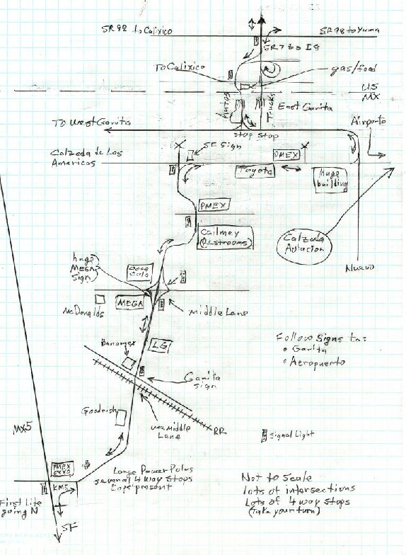
Mexicali East directions

PaulW - 5-28-2015 at 11:36 PM

Here is my route. Map is reasonably accurate if one notes the landmarks.


And here is how to decide when to cross the border
http://traffic.calit2.net/border/border-crossing-wait-times....
Paul

cj5orion - 5-29-2015 at 06:40 AM

https://www.google.com/maps/@32.625,-115.413282,14z

David K - 5-29-2015 at 07:13 AM

Quote: Originally posted by cj5orion  
https://www.google.com/maps/@32.625,-115.413282,14z


This shows MICK's route very well (Calzada Manuel Gomez marooon to Avenida Argentina to border).

Looks like Paul's sketch is another route further east but parallel and reaches the border east of the crossing instead of west?

treuboff - 5-30-2015 at 09:30 PM

Mexicali 6am 15 mins.