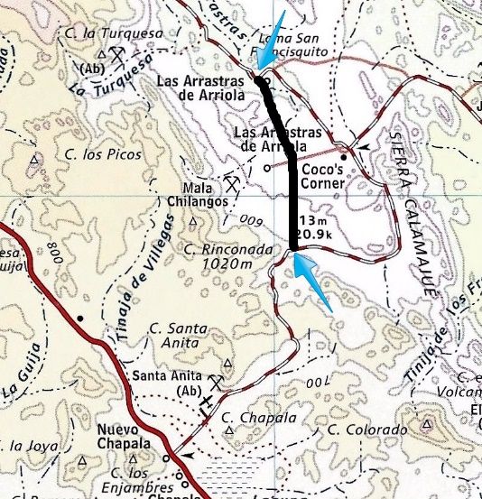
6.1 miles south of the end of pavement (Km. 170.5) and 3.8 miles north of Coco's Corner is the site of Las Arrastras de Arriola a former gold mill and
ranch with a well. The existing road curves east then south again here and heads for Coco's Corner. The new highway appears to be going straight ahead
and in the distance, construction dust is visible where a mountain is being reduced.
The new highway construction meets the existing road again 3.7 old road miles south and then west from Coco's Corner. Coco gives a figure of 2.5 kms.
(1.5 miles) from his place west to the new highway route.
Taken week before last, same second time through last Monday:
No new roadbed traveled beyond the end of pavement.
Las Arrastras de Arriola (note dust in distance).
Well used now for construction water trucks.
3.7 miles southbound from Coco's Corner, meeting construction equipment again.
New highway route (between blue arrows).
A week later, northbound:
Paved ramp up to end of new highway (Km. 170.5), 10 miles north of Coco's/ 12.5 miles south of Rancho Grande/Alfonsina's Pemex (Km. 150). StuckSucks - 8-3-2015 at 05:48 PM
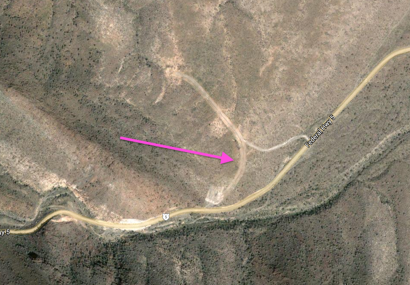
According to your map, the south end of the new road hits the old Highway 5 around the bottom of the canyon which leads up to Laguna Chapala:
I see on Google Maps that there appears to be some new grading in that area - wonder if that's related to the new road?
thanks for the maps and infoDavid K - 8-3-2015 at 09:55 PM
It was about where the mountain part begins. Note the map does not show the current road correctly between Coco's and there. It doesn't loop way south
then come back north. After clearing the mountain south of Coco's it goes straight to the blue arrow.Cliffy - 8-3-2015 at 10:31 PM
So what happens to Coco?
New grading next to 5
AKgringo - 8-3-2015 at 11:04 PM
From the google photo, it appears that they might be setting up a quarry and batch plant to support the new construction.ehall - 8-4-2015 at 05:23 AM
Traffic is going to drop way off. A lot less first time visitors. But who knows? Hope he is still able to make a living.
As I said in my trip report, Coco is happy to not have all the highway noise. As he is on the road to Calamajue mission and port, he will still have
off roader traffic.freediverbrian - 8-5-2015 at 07:24 PM
I remember a family living in the wash in the early 80s mining turquoise and polishing the stones for sale .Tough life no power no water. On the
next trip thru to Gonzaga we took down a hand crank polisher and gave it to him he was so happy he gave us his whole box of stones . As a teenager it
made an impression on me that last today . Give David K - 8-6-2015 at 08:44 AM
I remember a family living in the wash in the early 80s mining turquoise and polishing the stones for sale .Tough life no power no water. On the
next trip thru to Gonzaga we took down a hand crank polisher and gave it to him he was so happy he gave us his whole box of stones . As a teenager it
made an impression on me that last today . Give
That was at Las Arrastras?
In Jim Hunter's guide 'Offbeat Baja' c1977 is a nice story about the Manuel Cantrera family that once lived there.freediverbrian - 8-6-2015 at 05:45 PM
Yes now that I think about it, it was in the late 70s. We would drive into gonzaga from highway 1 , the road from San Fielipe was too rough.David K - 8-6-2015 at 05:59 PM
Yes now that I think about it, it was in the late 70s. We would drive into gonzaga from highway 1 , the road from San Fielipe was too rough.
Yes, the part from Puertecitos to Gonzaga was just avoided by most after Hwy. 1 was completed and offered a shorter route to pavement from Gonzaga. My
last time over the 'Gonzaga Grades' south of Puertecitos on the old road was 1979, pre-running the Nov. '79 Baja 1000.
Here is a page from Jim Hunter's 1977 book about the family at Las Arrastras:
basautter - 8-6-2015 at 06:34 PM
Nice....I think....David K - 8-6-2015 at 11:28 PM
Here's a map I made using satellite image, which correctly locates the current road south of Coco's Corner.
On a topo map...
The new route cuts off approx. 2.5 miles between Gonzaga Bay and Laguna Chapala.
The first 1/3 of the new route south of Las Arrastras will likely obliterate the 1767 Camino Real mission road. Not much more than a cattle trail in
this section, but because some were concerned when a motorcycle group planned to ride on some of it near here, I wonder what kind of outrage this will
bring on?
Here is a satellite image with push pins marking El Camino Real where seen from space in close up views...
Here is the 1954 Gulick El Camino Real route map. San Francisquito (San Francisco) is the water hole on the trail, just hundreds of feet west of Las
Arrastras...
[Edited on 8-7-2015 by David K]David K - 8-7-2015 at 12:08 PM
All kinds of vehicles are on this 23 mile graded dirt/rock road. However, any campers, motorhomes, trailers will have a slow rough ride. 18 wheelers
are using it, and 4WD is not necessary. I personally do NOT recommend any big RV camper or motorhome on it. It will be a painful 3 hour drive, I
think.rts551 - 8-7-2015 at 12:41 PM
The first 1/3 of the new route south of Las Arrastras will likely obliterate the 1767 Camino Real mission road. Not much more than a cattle trail in
this section, but because some were concerned when a motorcycle group planned to ride on some of it near here, I wonder what kind of outrage this will
bring on?
You just couldn't help but egg it on, could you. You like that kick me sign.David K - 8-7-2015 at 01:57 PM
??
Compared to a motorcycle tire track, how else do you not get upset when a bulldozer erases, not just drives over the trail?
Seriously, from El Rosario north to San Francisco, CA the Camino Real is mostly under a paved highway... and some bells are placed along the approx.
route to educate those interested.
Except for some work east of Mission Santa María, the Camino Real north of San Borja is mostly just an animal trail. The Jesuits (who constructed the
well built road north from Loreto to San Borja) were expelled before their quality roadbed could be extended to Calamajué/Santa María (their final
mission). The Franciscans and Dominicans just did not have the desire to build such roads, now that California was under Spanish civil government
control.rts551 - 8-7-2015 at 06:15 PM
The outrage.. Oh my god. your turning liberal.TMW - 8-7-2015 at 07:32 PM
I got this from a friend in San Felipe. I tried to copy the text and translate it to English but for some reason I couldn't copy it.
Good link, right click for English translation (Windows 7), that bridge construction was between the end of pavement and Las Arrastras.Cliffy - 8-8-2015 at 08:12 PM
Used to be lots of El Camino Real bells along 101 in Calif before the freeway took them outDavid K - 11-29-2015 at 02:31 PM
Bump!AKgringo - 11-29-2015 at 02:43 PM
Thanks for the bump Dave, I had lost track of this thread. Here's hoping it stays relevant!David K - 11-30-2015 at 01:24 PM