Since there are no summer roads over the Mackenzie Mountains, if one is in the east part of the Northwest Territories and thinking about possibly
visiting the west part of the Northwest Territories, they must first drop down into a bit of British Columbia and then into the Yukon. We really did
not know where we were going as we plan as we go. So after visiting Fort Simpson, we headed south and west.
A few miscellaneous pictures from Fort Liard in the Northwest Territories to Teslin in the Yukon
Where we camped along the Liard River --- so many beautiful rivers and lakes they almost become oh well, just another river. This one just has a bit
of a Sleepy Hollow feel.
Campground at Toad River in BC --- they grew their own veggies for their restaurant ---
Toad River---- water levels were high everywhere and it rained more days than not. In northern BC and in the Yukon we were told it was a quite cold
and wet summer and meantime the south was on fire.
A plane on Muncho Lake in BC --- the north is very dependent on these planes.
Looking the other way at Muncho Lake
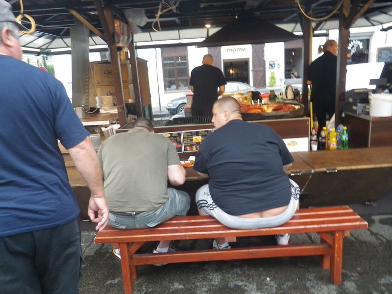
We thought these guys had been in the back country maybe a bit too long. We just couldn't resist.
The famous Sign Forest in Watson Lake in the Yukon. It now has over 70000 signs almost twice as many as were there when we there about 16 years ago!
It used to be just signs that people brought with them, but now they also have people in town who will make signs for people.
The very long Nisutlin Bay Bridge in Teslin, Yukon. Teslin is a major center for the Tlingit --- historically it also was a major gathering center
It just made us smile --- the worst ghost police car we have ever seen. But maybe.
Thanks for looking ---
[Edited on 9-11-2015 by DianaT]motoged - 9-10-2015 at 04:31 PM
Diana,
Thanks again for more of your trip....
This guy.....
has a winter truck driving job just south of Redding on I-5....
DianaT - 9-10-2015 at 04:35 PM
At least they are not all plumbers! Skipjack Joe - 9-10-2015 at 05:35 PM
You should have added DavidK's Viva Baja sign to the collection.Ricardo - 9-10-2015 at 06:41 PM
No not plumbers, looks like crack peddlers to me.Ricardo - 9-10-2015 at 07:41 PM
No I guess not they would have to be peddling a bike and us watching from behindtripledigitken - 9-10-2015 at 07:49 PM
Really enjoying the photos of your summer trip. My favorite of this group is the first. Nice processing!
Anxious to see the Dempster shots.DianaT - 9-10-2015 at 08:29 PM
Really enjoying the photos of your summer trip. My favorite of this group is the first. Nice processing!
Anxious to see the Dempster shots.
Thanks Ken --- I am glad you like that processing. To me, it took it to the Sleepy Hollow that it felt like at the time.
So many places on this trip including playing with the grizzlies in Haines, but maybe I will jump forward to the Dempster. It was such an amazing
experience and so overwhelming --- we need to do it again now that we have been there and know more of what to expect. BajaBlanca - 9-11-2015 at 03:26 AM
Oh my! That guy also has a cousin in POLAND!
Diana - your photos are really beautiful. What beautiful scenery....you must feel like you are in heaven.DianaT - 9-11-2015 at 10:24 AM
Thanks Blanca --- I guess some fashion statements are simply universal. bufeo - 9-11-2015 at 10:41 AM
Love those photos (well, maybe not all ), Diana. Maybe we'll put the NWT back on
our 'shorter' list.
We have a sign (Los Olivos) among those in Watson Lk, but we placed it, with permission, in 1973. I wouldn't have a clue where to look for it in the
midst of that bunch.
Allen Rwessongroup - 9-11-2015 at 10:53 AM
Hey T ... were you stalking that guy ...
And as always thanks for sharing ... always good traveling with you guys ... and your "eye" just keeps getting better
Good vibe from those "shots" ... nice
WOOF !! ..
[Edited on 9-11-2015 by wessongroup]DianaT - 9-12-2015 at 08:52 AM
Not until we can't do it anymore! Getting appointments out the way and then headed east. And we love it around here! Whale-ista - 9-12-2015 at 06:19 PM
Amazing places and great photos! Thanks for sharing your trip.DianaT - 9-13-2015 at 08:49 AM
Diana, how far north did you go? Latitude? Name of the most northern town?
Drove the Dempster Highway to Inuvik, 68.3617° N, 133.7306°
It was a wonderful experience and I want to do again, especially since they are working on completing the Dempster the additional 60+/- miles to
the Arctic Ocean. It will probably take a couple more years. Right now, to reach Tuktoyaktuk we would need to fly or be there in the winter and
take the ice road.
We thought about Prudhoe, but we thought the Dempster was enough for one trip.
A few photos to come later. :-)
[Edited on 9-13-2015 by DianaT]SFandH - 9-13-2015 at 09:27 AM
Above the arctic circle @ 66.5628 n
wow! great trip
Check out Diana's coordinates - 68.3617 n, 133.7306 w - with maps.google.com or google earth.