BajaNomad

East Coast of Baja Beaches, Tides, and Winds

sargentodiaz - 9-26-2015 at 12:02 PM

Well, once again, DavidK screwed up my novel writing by directing me to a book about Father Consag and his explorations of Baja in the 1740s & 50s.

None of it seems to match other things I've seen and read about Baja. So, maybe those of you who live there can set me straight.

In his diary of his 1746 voyage, he talks about encountering many long, sandy beaches.

He also relates a number of streams with potable water and lots of vegetation.

He also describes quite strong tides where boats floating in the evening end up grounded on rocks in the morning.

He describes strong on- and offshore breezes, along with squalls that nearly upset his boats. Extensive winds from both north AND south. (I thought the biggest problem of sailing from San Blas or Alcapulco to Baja - especially Loreto, was the contrary winds.

He also reported seeing lots of wild sheep and "goats". The latter surprises me because I know of no species of wild goats in North America. I'm guessing they were antelopes.

I'm wondering about this because sandy beaches usually only occur where there are strong wave actions. Without strong waves, they tend to be very rocky or with pebbles. Are there strong wave actions against the eastern coast?

Someone who lives there or spends a lot of time there, please set me straight! If you wish I can send you a copy of the part of the book describing his voyage.

Thaanks.

Russ - 9-26-2015 at 02:05 PM

Yes strong winds besides the hurricanes there are storms that effect the beaches but there are many that are always sandy. Some beaches change seasonally. Also depends on the direction the beach faces during seasonal storms.
Fresh water can be had from the back of some estuaries.
Antelope, I think that plural too, are native to many areas. After the first Spaniards could be goats too. Haven't heard of wild goats here though in recent history.
That's just my thoughts. And I believe DavidK gives accurate info the majority of the time given the references he uses and he uses many sources most don't take the time to research.
You're asking historical questions that may not be valid today. Especially fresh water locations.
I just googled, History of Baja California and there is a ton of info there.


[Edited on 9-26-2015 by Russ]

wiltonh - 9-26-2015 at 02:31 PM

The amount of wind has a lot to do with the time of year. In the winter the wind comes mostly from the North. It can be quite strong at times and the waves can become quite large. I have seen waves out at sea that were over 30 feet when the wind was blowing 30 to 40 knots. A few years ago they flipped a gasoline barge making the crossing to the mainland. The real issue, when crossing, is that the strong wind and waves are coming from the side of your intended path.

We spend the winter there on a beach which has 24 miles of sand. There are many others like that which you can check out using Google earth.

Water can be found in a number of places and history shows that many old sailing ships stopped at Cabo to refill with water. Water is precious so the locals have built water catchment systems which probably reduces the amount that gets to the ocean.


Mountain Goats

AKgringo - 9-26-2015 at 02:41 PM

I have seen them in the Chugach range in AK, from sea level to well above timberline. I don't know if they ever ranged as far south as Baja, but they are found down through the Cascade and Rocky Mountain ranges.

You are correct in that genetically they are more closely related to antelope than domestic goats, they look more like goats.

bajabuddha - 9-26-2015 at 03:32 PM

GOATS:
Mulegé is full of 'em.... OLD ones..... all seriousness aside, there are Desert Bighorn in the Gigantes range and behind Coyote-Santispac stretch. I'm sure the populating of the area drove down numbers of fauna drastically and quickly, just like in the desert southwest U.S. I have seen mule deer in the Coyote area (just south of). Antelope range more on the western side of the peninsula, especially in the Viscaino areas.

David K - 9-26-2015 at 08:50 PM

Historical books, not me have you correcting your books Dale!

As for your questions about what Consag wrote, it is very much like that today... just fewer animals maybe?

Bighorn sheep and pronghorn must have been much more numerous in 1746? However, so were the Native Indians, who ate those two species!

Strong tides and currents are indeed the norm, especially from Bahia de los Angeles to the Colorado River, where Consag sailed in 1746. The tidal range at San Felipe is one of the world's top regions at 20 feet of more change. The sea can go out a half mile at low tide, easy up near San Felipe.

Sandy beaches are many, all where there are no normal waves. From south to north, all visited by Consag:

Punta San Franciquito
Bahia San Rafael
Bahia las Animas
Bahia de los Angeles
Bahia Guadalupe (Remedios)
Ensenada de San Francisquito/Bahia San Luis Gonzaga complex
Punta Bufeo
Nuevo Mazatlan and 25 miles north to San Felipe and then for many miles north of San Felipe are all sand beaches.

David K - 9-26-2015 at 09:25 PM

I just went to Historum and replied there to your post... here is some of what I shared...


Consag made three expeditions to seek new mission sites north from San Ignacio, one by sea in 1746 and two by land in 1751 and 1753.

The first land trip kept him mostly on the Pacific slope of the peninsula and the second land trip kept him mostly along the gulf slope.

Baja is not that wide in that region and from the tops of some peaks you can see both coasts. The Pacific coast is usually under a cloud or fog bank, so the ocean will be hidden... but not always.

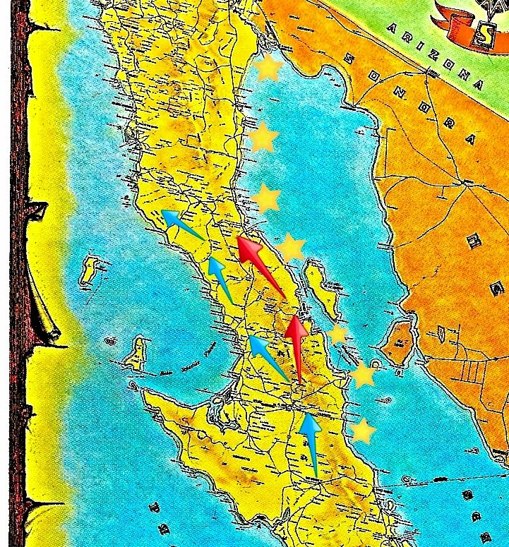
Not sure how this will look online, but I just made this map for you as a visual aid...

The stars on the east coast of Baja are his 1746 route.
The blue arrows are his 1751 route.
The bottom blue arrow and the red arrows are his 1753 route.
The bottom blue arrow begins at San Ignacio, Consag's mission. That blue arrow points to (near) La Piedad, which became Mission Santa Gertrudis in 1752.
The bottom star is at 'San Carlos' landing where the sea expedition began.

sargentodiaz - 9-27-2015 at 10:30 AM

Quote: Originally posted by David K  
I just went to Historum and replied there to your post... here is some of what I shared...


Consag made three expeditions to seek new mission sites north from San Ignacio, one by sea in 1746 and two by land in 1751 and 1753.

The first land trip kept him mostly on the Pacific slope of the peninsula and the second land trip kept him mostly along the gulf slope.

Baja is not that wide in that region and from the tops of some peaks you can see both coasts. The Pacific coast is usually under a cloud or fog bank, so the ocean will be hidden... but not always.

Not sure how this will look online, but I just made this map for you as a visual aid...

The stars on the east coast of Baja are his 1746 route.
The blue arrows are his 1751 route.
The bottom blue arrow and the red arrows are his 1753 route.
The bottom blue arrow begins at San Ignacio, Consag's mission. That blue arrow points to (near) La Piedad, which became Mission Santa Gertrudis in 1752.
The bottom star is at 'San Carlos' landing where the sea expedition began.


Once again, you hit it outta the park!

Thanks

David K - 9-27-2015 at 11:29 AM

I do try to please!