I rode my bike up to the construction site yesterday. The 'road' is a bit more than a mile long and leaves Rt. 1 at mile post 120. It is a new road
with all that the word implies. Lots of loose rocks, puffy dust on the corners and whoop-de-doos from construction truck traffic. Four wheel drive or
a motorcycle only. Low gear. There is one wire gate near the pavement and a small guard structure just past the gate (no one there).
There were perhaps 20 guys at the top working on the building. The walls were up to about chest height. Nice view. Friendly bunch. For those who want
the location it's 26 deg., 48.727N. 111 deg., 54.483 W. I could see much of Bahia Conception but it didn't look like there was quite a line of sight
to the Northern beaches. We'll see how it works.
Mike-Mulegebajabuddha - 11-27-2015 at 03:13 PM
Mike, just curious; as a ballpark placing, is that at the far south end of the Bay? If memory serves (less and less these days) Buenaventura is KM
91... or am I blowing smoke?
edit: I tried your GPS #'s on google earth, and they don't work; but doing a manual zoom to what's close to your data it looks like it's half-way
between the Tiburon Microonda tower and Playa Naranjo at the northern end of the Bay.
[Edited on 11-27-2015 by bajabuddha]David K - 11-27-2015 at 03:23 PM
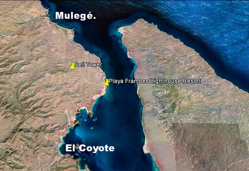
I went to Google Earth, and that waypoint is on the mountain, west of Bob & Susan's Lighthouse Resort, Km. 118 (ie. north end of the bay). Km.
markers go higher northbound. In this case Km. 0 is Loreto.
I would post a map... but that irritates some of you! Howard - 11-27-2015 at 03:47 PM
Come on Uncle Davey, we would like a map, we need a map and we fully expect a map!
Don't let some old curmudgeons ruin your joy in life, maps!David K - 11-27-2015 at 04:15 PM
Come on Uncle Davey, we would like a map, we need a map and we fully expect a map!
Don't let some old curmudgeons ruin your joy in life, maps!
LOL
Well, if you want to see the cell tower location, just go to Google Earth and paste this into the search box and hit enter: 26º48.727, -111º54.483
[Edited on 11-27-2015 by David K]BAJA.DESERT.RAT - 11-27-2015 at 04:35 PM
Hola david k.
i for one am never irritated by your map postings. i am just amazed how much and how fast you post for most of our behalves, newer and older maps.
please just ignore the irritated souls.
BIEN SALUD, DA RAT
Howard - 11-27-2015 at 04:50 PM
Sorry Uncle Dave, why would we use Google when we have you?
I know you are breaking out in a sweat and just waiting for some additional encouragement to send a map!
Come on and stop teasing us, send us the damn map! )
.bajabuddha - 11-27-2015 at 05:11 PM
Sorry Uncle Dave, why would we use Google when we have you?
I know you are breaking out in a sweat and just waiting for some additional encouragement to send a map!
Come on and stop teasing us, send us the damn map! )
.
HERE, HERE !!
I totally concur; it's not maps that irritate people, it's people who irritate people (especially when they make every thread about
themselves). I have personally said many times that maps are what you do best; you should stick to 'em.
Palm trees? ......... meh..... Gulliver - 11-27-2015 at 05:27 PM
It was very apparent that Bob and everyone in the developments along the point are likely to have a great cell phone signal. The question is whether
Santispac, El Burro and the others will get enough reflections to connect reliably. Who knows how tall the tower will be? We'll see.
It was very apparent that Bob and everyone in the developments along the point are likely to have a great cell phone signal. The question is whether
Santispac, El Burro and the others will get enough reflections to connect reliably. Who knows how tall the tower will be? We'll see.
Mike
Good point, Mike. Since you were up there, you'll have a good idea of who; cells are microwave, and it's all line-of-sight. Those who are on one
side of a beach against a hill won't have any, when their neighbors a few hundred meters away will... but progress marches on. Better than driving
20 miles to town when you can walk to a friend's house. Even signals in Mulegé can be spotty because of the terrain.
Lordy, how did we ever survive without it? I miss the phone booths in the store at the 4-way......... motoged - 11-27-2015 at 06:21 PM
.....I would post a map... but that irritates some of you!
Oh, simmer down, Davey...... we like maps, but not when we overdose on
them.....David K - 11-27-2015 at 08:01 PM
I have to think about now being called Uncle Davey... DK, Dave, or David has been the norm here (of the printable names allowed, lol).
When I became an uncle (in 1967 and 1968) it wasn't too many years before Uncle David became 'Uncle Baja' to my two nephews back when I was
babysitting them often when I was 15-17 and busy writing my first Baja travel guides.
Here you go... yellow push pin, labeled "Cell Tower"...
MulegeAL - 11-27-2015 at 08:23 PM
I feel so much better, these threads are nothing without your maps, thanks DK!
I can't wait to get out there and find the giant yellow stick pin, can't be that hard to locate!chuckie - 11-27-2015 at 10:08 PM
AL! You made a funny!David K - 11-27-2015 at 11:42 PM
I wonder how Bob & Susan feel about the yellow pin I put in their swimming pool!Howard - 11-28-2015 at 12:40 AM
Thank you David, the world is back to it's normal spin.MulegeAL - 11-28-2015 at 08:22 AM