
DEVEAU - 12-3-2015 at 06:14 PM
Sorry for a quick report, no time for photos. 5 of us rode our dirbikes into Mike's the evening of 11/25, simple rice from Tecate. My brother said he
had co-ordinates to the Pole Line in his phone and wanted to try it the next day. Sounded like a good way to kill a day.
We left Mike's about 8:30 the next morning. Stopped in V.D.T. for fuel and a minor repair, voltage regulator broke-off and jambed in the shock
linkage, took 30 minutes to fix.
Up the Goat trail and onto to Summit, in better condition than a couple of years ago. At the bottom we found the locked pole gate. Must have been a
big storm lately, the wash was wiped clean, not tracks. We did not know about the detour, so we just wiggled past the gate. The other pole gate on the
other side was easy to get around, the cables were loose.
Between the phone and the tracks the next couple of hours were pretty easy, saw Basketball Hill, the cobblestone pavement and the White water tank.
But when we dropped into Jaquegel we lost the trail. We knew we wanted to go right, but the tracks were all wiped clean and the bank scoured 10 feet
up the bank. We weren't lost, just could not find the Pole Line anymore.
After hunting around for an hour or so we decided to head down the wash and keep working right. Figured we would hit the racecourse if we kept heading
toward La Ventana. The wash was a real pain in the @#$%^^, no tracks and lots of rocky section, could not get a rhythm going.
Eventually hit the racecourse heading South. Had to fix a front flat in the dark, not a real problem. Then just headed toward the headlights on the
highway. We were way North of where we wanted to be. Not a fun 60 miles of pavement on bikes. Had to share fuel a couple of times but made it to San
Felipe by 9:00 PM with no real problems. Boy did the beer taste good.
More on the full Six Days later, Rich
David K - 12-3-2015 at 06:25 PM
Awesome Rich!
Yes, where the Pole Line Road dips back in Jaquegel the final time is where we camped, and the road back out was right there. It was just a couple
hundred feet from where it dropped into the wash to where it climbs back out. That is where we did some road building... mostly so we could tow the
crippled Ford out. TW was the hero!
Looking forward to the photos!
ehall - 12-3-2015 at 08:25 PM
I could see the exit getting unmakable with a good flood. At least for 4 wheeled vehicles.
David K - 12-3-2015 at 10:44 PM
Maybe a big arrow painted on the rock face of the cliff could help future east-bound travelers see the way out? Call if graffiti now, or pictographs
for people 500 years from now!
Ken Cooke - 12-12-2015 at 07:39 AM
That sounds like a fun ride! Yes, the wash is now difficult to cross. The burned out Chevy truck at the top of Basketball Hill and the toppled
Suzuki Samurai make it look even more intimidating!LOL That sure is great country for an off road adventure.
PaulW - 12-12-2015 at 08:19 AM
DEVEAU,
After hunting around for an hour or so we decided to head down the wash and keep working right. Figured we would hit the racecourse if we kept heading
toward La Ventana. The wash was a real pain in the @#$%^^, no tracks and lots of rocky section, could not get a rhythm going.
Eventually hit the racecourse heading South. Had to fix a front flat in the dark, not a real problem. Then just headed toward the headlights on the
highway. We were way North of where we wanted to be.
= = =
Your description leaves missing details? Did you pass by near the wells and did you end up on Hwy5 near La Ventana (Km106). Did any of you make any
GPS waypoints between the first place you got lost and further on that you can share?
Thanks
Ken Cooke - 12-12-2015 at 10:10 AM
Our April 2015 group hunted for roughly 1 hour - while towing a full-size Bronco through the wash, looking for a means of crossing it, but couldn't
find one. Water had carved deep grooves through the soil to the tune of about 4'-5' in depth.
Even if the path was located to cross the wash, it is unlikely that it could have been crossed due to the rockcrawling that would have been necessary
to negotiate the flooded out wash. Extra time and extra gasoilne would have been necessary to find a route to Ej Sadaña.
ehall - 12-12-2015 at 11:36 AM
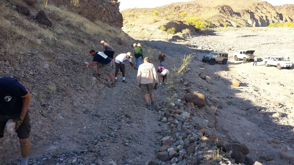
You can see both roads in this picture.
[Edited on 12-12-2015 by BajaNomad]
David K - 12-12-2015 at 05:30 PM
In the above photo, the Pole Line Road is the one everyone is working on coming up, out of big Arroyo Jaquegel... and you can see straight across the
side wash that comes in from the left and the Pole Line road we had been on the night before drops down to Jaquegel at this side wash, crosses it and
climbs back out, where we are working on it. We camped to the right of the vehicles ion the photo.
Not bad for a road made in 1942!
