BajaNomad

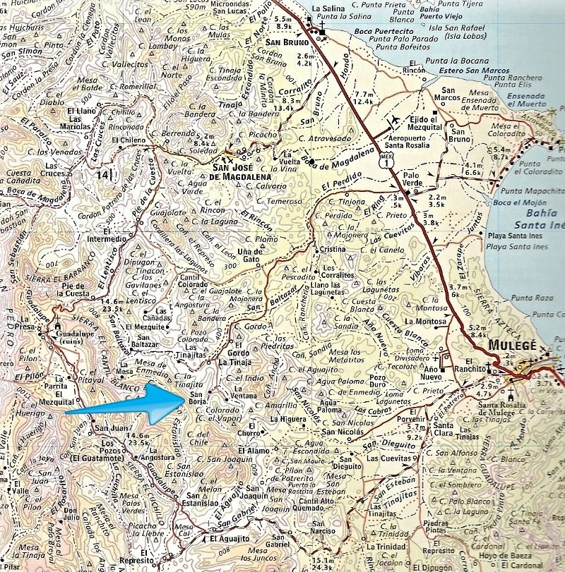
Road to San Borja Baja Sur. December 2015

Gulliver - 12-24-2015 at 07:57 PM

Explored the road from Rt. 1 to near the cave paintings at San Borja today.

The storm waters have done their thing all along the way. Back and forth across the channel we go. Where the road is not in the river, it isn’t that bad. And the water crossings aren’t that deep or long. But anywhere the road was in the water course it was washed away and the ranchers have driven along and compressed the round rocks enough to get through. In a four wheeled rig it isn’t so bad but on my bike it was tedious.

Zero miles when you leave Rt. 1 at Palo Verde. The first few miles are fast and level.

6.4 miles, gate. You know the drill.

Around nine miles ( I forgot to write it down) a Y to the right to go to Una de Gato and maybe the back road into San José de Magdalena. Not today. I lacked sufficient energy or time. N26 deg., 58.126’. W112 deg., 12.817’. And another acute crank to the right a short distance on that I think connects to the same road. N26 deg., 57.86’. W112 deg., 12.42’. Go nuts with Google Earth.

28.9 miles. N26 deg., 53.54’. W112 deg., 15.96’. End of the road for me at La Tinaja. Jesus, Esmeralda and 6 year old son Manuel. Perhaps the most beautiful mountains around their rancho I have seen in ages. The last bit to Las Tinajitas is washed out pretty bad and I was way past my nap time. Frankly, I’d had enough of river bottoms for the day.

Just before Tinaja is the locked gate on the left to the San Borja site. Paintings I think. Need a guide. I guess there have been issues.

Next time up there I head through Una de Gato to see what happens.

Enjoy,
Mike


[Edited on 12-26-2015 by Gulliver]

bajatrailrider - 12-25-2015 at 08:58 AM

Thank you for all your posts,and interesting pictures.Hope to ride with you,go exploring.

Gulliver - 12-25-2015 at 02:10 PM

Probably find that riding with me is a crashing bore as I tend to stop a lot and take pictures and notes, pet dogs and pick my nose.

mcnut - 12-25-2015 at 03:01 PM

My kind of rider!

Mike, thanks for having a go at it. I have been interested in the Gato route since before the washout. Even created a track from GE to follow, just never had the opportunity but definitely on the to do list. Perhaps with time the wash roadbed will improve....or not.

For those that might be interested the cave paintings (Pinturas Rupestres San Borjita) are located at 26 deg 52.05 min, 112 deg 15.48 min (26 deg 52 min 03 sec, 112 deg 15 min 30 sec). GE has several photos, paintings and the setting look impressive compared to others I have seen.

A fine ride report! Merry Christmas.

Bruce

[Edited on 12-26-2015 by mcnut]

David K - 12-25-2015 at 09:07 PM

Quote: Originally posted by mcnut  
My kind of rider!

Mike, thanks for having a go at it. I have been interested in the Gato route since before the washout. Even created a track from GE to follow, just never had the opportunity but definitely on the to do list. Perhaps with time the wash roadbed will improve....or not.

For those that might be interested the cave paintings (Pinturas Rupestres San Borjita) are located at 26 deg 52.05 min, 112 deg 15.48 min (26 deg 52 min 03 sec, 112 deg 15 min 30 sec). GE has several photos, paintings and the setting look impressive compared to others I have seen.

A fine ride report! Merry Christmas.

Bruce

[Edited on 12-26-2015 by mcnut]


Gulliver - 12-26-2015 at 09:55 AM

As per my report, the gate where the road to the paintings branches off about a quarter mile before La Tinaja is chained and locked so if anyone wants to go see the paintings they will need to go find a guide. Probably at either La Tinaja or Las Tinajitas.

MulegeAL - 12-26-2015 at 10:16 AM

Yup, go up to the rancho. The sign-in logbook is there up on a shelf near the table of the outdoor kitchen/table area. Lots of history in that book! Bring some pesos.

The elder that used to do this would let me go in on a moto and hike up on my own, but the new hand there won't let me do that anymore!

It's gotta be behind lock and key because it is a national treasure, amazing place, almost 8000 years old (like me!)


[Edited on 12-26-2015 by MulegeAL]

David K - 12-26-2015 at 11:35 AM

Fantastic site indeed!
I have not been in that far on that road, just to El Perdido. I recall all the signage from Highway One in calls the site SAN BORJITAS ?

MulegeAL - 12-26-2015 at 01:19 PM

Yes, that is correct.

If you havne't been in there DK you gotta go before you die. Amazing place, about half mile hike up the canyon.

Needs high clearance, good tires and maybe occasional 4WD depending on the condition of the riverbed at the end; could just park there, but no shade. I went in with my Pathfinder a few times and used 4H as needed for traction insurance here and there, easier than using a shovel!

David K - 12-26-2015 at 01:30 PM

Thanks Al, it does look amazing. We really enjoyed the giant art cave of El Carmen east of El Arco, as well as all the cave art sites with smaller paintings and petroglyps.

I would hope that after the drive there would always be someone at La Tinaja or Las Tinajitas, if the gate was locked?

What is the appropriate or requested gratuity for him to open up the gate and escort you?

MulegeAL - 12-26-2015 at 03:48 PM

Yeah, that is one of those little problemas. Riding in and out on a bike last time, I found nobody home at the rancho. No big deal to me with a bike. Pretty sure he was up the valley doing something based on the fresh tracks, but I didn't feel like chasing him down. Had I gone in there with the SUV I would'a been disappointed, especially if I had guests. But that is the way it goes sometime. Would be good to know what VHF or Marino radio band that rancho uses.

Used to be 100P, but last time he asked for 200P/persona, which seemed high. With today's exchange rate I do not know what the fee would be. Seems to me I heard the fees are supposed to be set by some governmental body, probably on the mainland.

I know when I went through the log book at the rancho there had been no entries since Oidle blew through (6 months), maybe because the road was so bad; the last half was pretty bad a year ago.

Not many entries in the book since hurricane Paul and Odile made overland travel more difficult. That log book is supposed to be the record of visitations to the site.

David K - 12-26-2015 at 06:58 PM

10-4, thank you!