BajaNomad

San Juanico -San Ignacio: The High Road

Zola - 12-26-2015 at 02:27 AM

Traveling north from San Juanico on December 2, we mistakenly stayed on the high road rather turn left for Campo Datil. Big mistake. I should have turned back to look for the road to Datil. The high road in parts feels as though it was recently graded, but it has some treacherous spots that I will not willingly drive again. Overall, it was much different from what it was like when I took it perhaps 2-3 years ago. In places I had to keep composed and drive very carefully, lest it be the last thing any of us ever did! Only one other time have I had the same feeling -- when I took the Ho Chi Minh trail to get to Black's beach: I promised myself that time that if I survived the trail, I would never willingly take it again! But maybe I am just a wuss.

It is however driveable if you have a very sturdy 4 X 4 with high clearance, and I suppose the plus side is that the underside of your vehicle will not collect as much salt. No one else seems to be driving it however. We didn't see a single vehicle until we reached the road that runs from the Laguna to San Ignacio. The people at the ranch were as nice and helpful as ever. I think they have seen far fewer motorists coming their way lately, or perhaps none at all, except for us. If you were to break down out there, you might just have to start walking to find help.

Otherwise, there was a little water at la Ballena, and the north roads are driveable. The rest of the drive was pleasant and easy. We drove at 10-15 mph most of the way from Chapala to the paved 5. There were surprisingly strong winds on the 5 in the mountains and also fallen rocks, but none that fell on us!

[Edited on 12-26-2015 by Zola]

TMW - 12-26-2015 at 11:31 AM

When I was thru there in April the rancher at El Cuarenta told me to go west not north at the jct after his ranch as the north route had been damaged by the rains. It was a pretty rough route until we got to the road to El Datil.

Zola - 12-26-2015 at 01:47 PM

Yes, when we came down we took the middle road to Campo Datil. Everything was fine until we traveled from Datil to SJ, where the route was strewn with boulders and holes, but it was manageable. The high road is barely manageable if you are feeling lucky! I will not knowingly take it again until further notice!

[Edited on 12-26-2015 by Zola]

David K - 12-26-2015 at 02:51 PM

Quote: Originally posted by Zola  
Yes, when we came down we took the middle road to Campo Datil. Everything was fine until we traveled from Datil to SJ, where the route was strewn with boulders and holes, but it was manageable. The high road is barely manageable if you are feeling lucky! I will not knowingly take it again until further notice!

[Edited on 12-26-2015 by Zola]


Thanks for the report. Did you record how far south from San Ignacio the pavement has reached?

AKgringo - 12-26-2015 at 04:09 PM

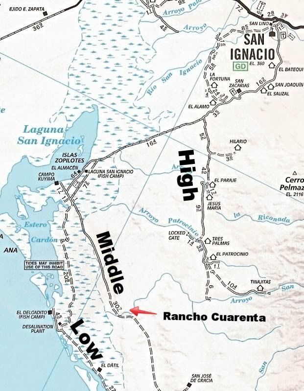
Two years ago, I tried to find my way north through San Juanico to Laguna San Ignacio, and got all kinds of turned around! As far as I can reconstruct my route, I believe I not only missed the low road, but the high road as well.

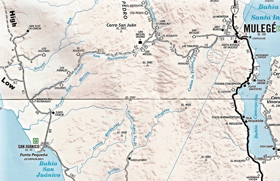
I believe I took the fork to San Jose De Gracia (shown on the map DK posted) and wound up following a ranch road through a variety of conditions. A few spots were rugged, and I was in low range a couple of times, but I never had to put my hubs in.

When I finally got on to a fairly good road, I came across a crew doing some repairs and improvements to a water crossing, I showed them my map (AAA), They told me I was at El Patrocino, and that there was no road where I had just come from!

Zola, I may have met you at the Cantina on the hill where I camped at San Juanico. Do you travel with a small pack of rescue dogs? If so, you were right when you told me I was gonna get lost if I didn't travel with someone who knows the way! I was driving a Small SUV and had an old black dog with a white chest and paws.


PaulW - 12-26-2015 at 04:21 PM

Quote: Originally posted by David K  
Quote: Originally posted by Zola  
Yes, when we came down we took the middle road to Campo Datil. Everything was fine until we traveled from Datil to SJ, where the route was strewn with boulders and holes, but it was manageable. The high road is barely manageable if you are feeling lucky! I will not knowingly take it again until further notice!

[Edited on 12-26-2015 by Zola]


Thanks for the report. Did you record how far south from San Ignacio the pavement has reached?

=====
Pavement ends at the beginning of the dike road
Drove the high road (Actually we call it the middle road) YESTERDAY

[Edited on 12-26-2015 by PaulW]

David K - 12-26-2015 at 07:21 PM


A road (not shown) connects the High Road to the Middle Road at Rancho Cuarenta. The Middle Road then become the High Road on south.

David K - 12-26-2015 at 07:24 PM

Quote: Originally posted by PaulW  
Quote: Originally posted by David K  
Quote: Originally posted by Zola  
Yes, when we came down we took the middle road to Campo Datil. Everything was fine until we traveled from Datil to SJ, where the route was strewn with boulders and holes, but it was manageable. The high road is barely manageable if you are feeling lucky! I will not knowingly take it again until further notice!

[Edited on 12-26-2015 by Zola]


Thanks for the report. Did you record how far south from San Ignacio the pavement has reached?


=====
Pavement ends at the beginning of the dike road
Drove the high road (Actually we call it the middle road) YESTERDAY

[Edited on 12-26-2015 by PaulW]


What (where) is the dike road? How far from a point on the AAA map so I can add the pavement to it?

TMW - 12-26-2015 at 08:09 PM

Quote: Originally posted by AKgringo  
Two years ago, I tried to find my way north through San Juanico to Laguna San Ignacio, and got all kinds of turned around! As far as I can reconstruct my route, I believe I not only missed the low road, but the high road as well.

I believe I took the fork to San Jose De Gracia (shown on the map DK posted) and wound up following a ranch road through a variety of conditions. A few spots were rugged, and I was in low range a couple of times, but I never had to put my hubs in.

When I finally got on to a fairly good road, I came across a crew doing some repairs and improvements to a water crossing, I showed them my map (AAA), They told me I was at El Patrocino, and that there was no road where I had just come from!


If you go to Google Earth there is a road from San Jose De Gracia to El Patrocino. It's sometimes hard to see but I have traced it out based on another persons travels.

Zola - 12-26-2015 at 08:10 PM

The pavement begins at the same place it began a year ago and two years ago. It seems to me that they are not extending it at all.

We took the road from San Juanico and missed the turn off to Campo Datil. We reached a sign. One way led to San Jose de Gracia. The other to the Laguna. We took the road to the Laguna. It was a very treacherous stretch. We then reached a ranch, received further directions, and paid a tip. From there there was only one place that was tricky, but it was very tricky. Then we came upon the road I have always called the high road, which led us to the road from La Laguna to San Ignacio. We were laughing in relief by then.


mtgoat666 - 12-26-2015 at 10:22 PM

Quote: Originally posted by David K  
Quote: Originally posted by PaulW  
Quote: Originally posted by David K  
Quote: Originally posted by Zola  
Yes, when we came down we took the middle road to Campo Datil. Everything was fine until we traveled from Datil to SJ, where the route was strewn with boulders and holes, but it was manageable. The high road is barely manageable if you are feeling lucky! I will not knowingly take it again until further notice!

[Edited on 12-26-2015 by Zola]


Thanks for the report. Did you record how far south from San Ignacio the pavement has reached?


=====
Pavement ends at the beginning of the dike road
Drove the high road (Actually we call it the middle road) YESTERDAY

[Edited on 12-26-2015 by PaulW]


What (where) is the dike road? How far from a point on the AAA map so I can add the pavement to it?


Not sure "dike" road is a good descriptor. The pavement ends about where the road enters the tidelands (mudflats). The road is constructed on fill that crosses the tidelands. Maybe Zola is calling the elevated roadbed a "dike"

[Edited on 12-27-2015 by mtgoat666]

David K - 12-26-2015 at 11:18 PM

It was Paul who said dike road. So has anyone recorded how many miles of pavement extend southbound from San Ignacio?

Zola - 12-27-2015 at 12:21 AM

I never monitored it, but I would say maybe 20-30 miles? Next time I will watch the odometer.

mtgoat666 - 12-27-2015 at 08:59 AM

Quote: Originally posted by David K  
It was Paul who said dike road. So has anyone recorded how many miles of pavement extend southbound from San Ignacio?


It's paved like a bunch of miles, my precise measurement found that the pavement (X) is accurately described as 20<X<35 miles

Are we there yet?

Further!

[Edited on 12-27-2015 by mtgoat666]

TMW - 12-27-2015 at 11:52 AM

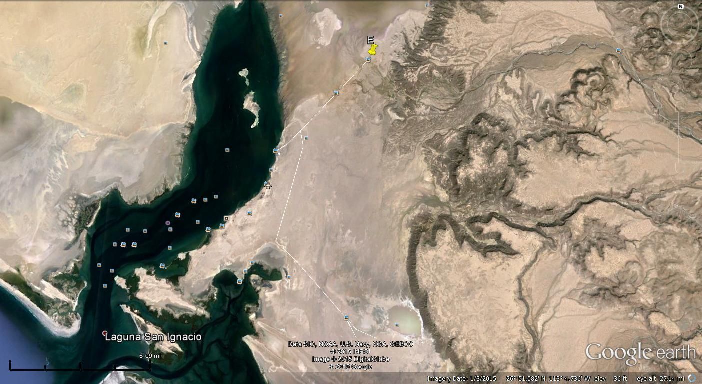
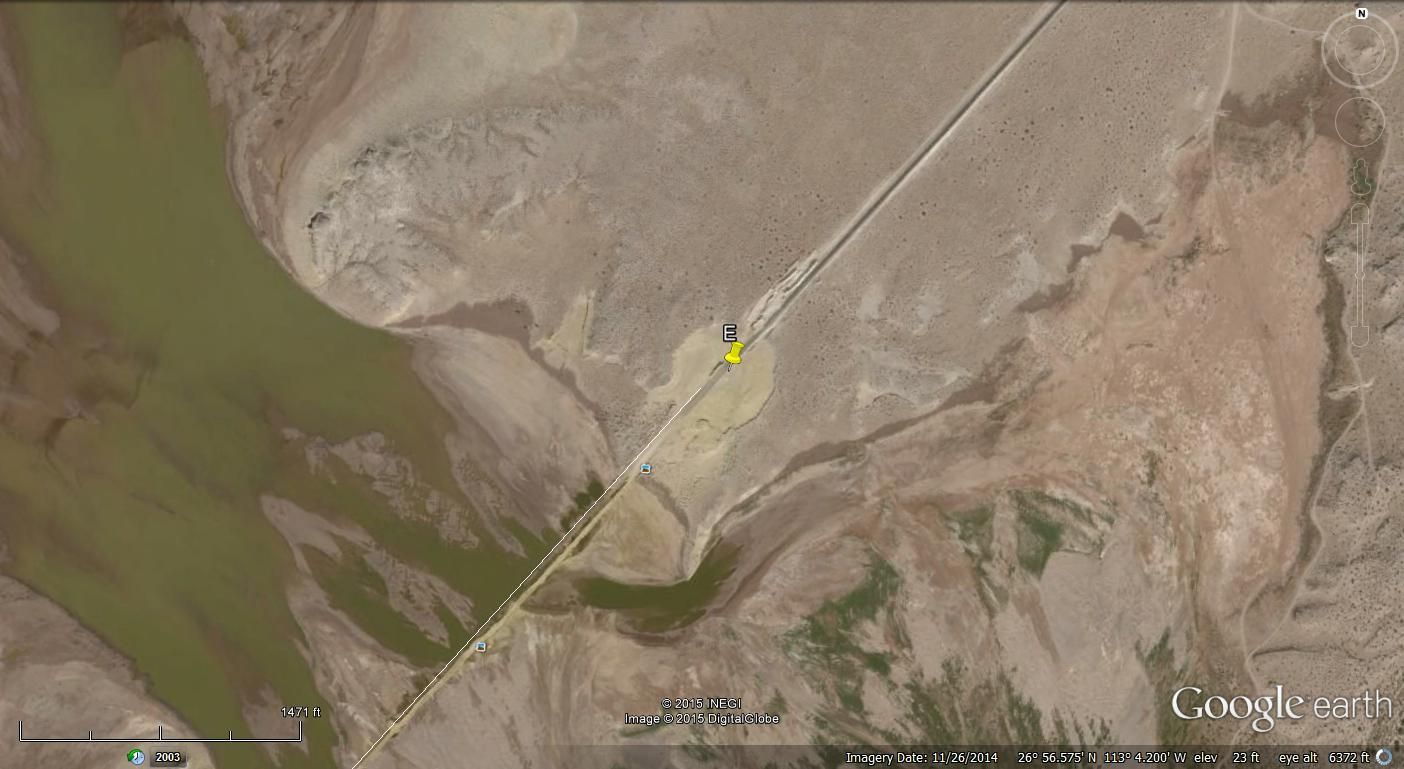
From these GE images dated Nov. 2014 they are about 4 miles from the fish camp. The E marker is at 26-56.57x113-04.20.


mcnut - 12-27-2015 at 12:10 PM

I believe the pavement on the road heading to the Laguna campos extends approximately 30 miles from the Mission ending at 26deg 56min 36sec, 113deg 04min 10sec. This is where the road finally enters the tidelands for extended periods.
Not sure it is a dike, more of an elevated or raised roadbed.

Bruce

mcnut - 12-27-2015 at 12:17 PM

Sorry for the redundant post Tom. Either it took me an hour to dig up or your post didn't display right away for me.

Bruce

PaulW - 12-28-2015 at 10:48 AM

I think there is hope for a better road south? The active gravel pit has been working quite a bit and the stock pile of gravel and mostly rocks is huge. It is just north of the dike.
There are two sizable washouts on the pavement that are in good condition with good gravel/road base. Slowing is not required.
The dike road is lumpy and slow is required.

mcnut - 12-28-2015 at 12:47 PM

I suspect the focus is to pave to the Laguna Campos for the tourists.

Bruce

David K - 12-28-2015 at 01:04 PM

As far back as 1973, a paved highway from San Ignacio south to join Hwy. 1 at Insurgentes had been proposed. This was to cut over 100 miles and two steep grades for traffic north and south of those two towns.

The businesses of Santa Rosalia, Mulege and Loreto were not happy with losing all that potential business from the soon to open Transpeninsular Highway. The plan was shelved, but pavement was extended from Insurgentes north to La Purísima and more recently to San Juanico. Close to half of the distance with the road south from San Ignacio included.

[Edited on 12-28-2015 by David K]

PaulW - 12-28-2015 at 03:15 PM

Speculation in San Ignacio is where the road will cross the canyon/water to get to Hwy1. Not many solutions for that connection. For sure they expect it to bypass the town.

Seems inevitable that a thru road will happen to connect Hwy1 to Insurgentes

TMW - 12-28-2015 at 04:04 PM

Quote: Originally posted by mcnut  
Sorry for the redundant post Tom. Either it took me an hour to dig up or your post didn't display right away for me.

Bruce


No problem and I think you are right they want a paved road so the tourist can see the whales. Think $$$$$ not that it is bad everyone needs to make a living.

TMW - 12-28-2015 at 04:09 PM

Also several years ago there was talk of a toll road from BC Sur to BC and it was to come by way of the Laguna area. Not much talk now I think because as David pointed out the towns along the Sea of Cortez don't want it or will delay it as long as possible. The toll road was to be a private built road like the one from TJ to Mexicali. Same company maybe.

David K - 12-28-2015 at 07:08 PM

Quote: Originally posted by PaulW  
Speculation in San Ignacio is where the road will cross the canyon/water to get to Hwy1. Not many solutions for that connection. For sure they expect it to bypass the town.

Seems inevitable that a thru road will happen to connect Hwy1 to Insurgentes


The river is underground once you are more than a couple miles from town. Of course, you need a bridge for the flash floods.

PaulW - 1-3-2016 at 09:35 AM

Here is a piece of our 1780 mile vacation travel from San Felipe to Del Cobo and back.
** Heading to San Ignacio northbound from Insurgentes via Datil we found 90 miles of pavement with a couple of short construction zones. Then 78 miles of dirt using the low beach road. (The dirt starts at the junction at San Jaunico when heading north). Then we crossed the dike which is 3 miles long including the hill near the north end. There are several bad places on the dike requiring careful tire placement. No evidence of construction south of the pavement end. Then 29.7 miles of pavement on the way to San Ignacio with one dirt section with lots of dust.
Lots of fun with the children in Datil. I bet they have not seen any tourists in a long time. The kids are sticker hungry.
Doing the math and we found from Insurgentes it is 175 miles shorter by way of Datil vs Hwy 1 via Mulege. The result is a huge time savings. If one takes the high road is probably is slower because the super fast beach road is so good. We went south during the full moon and the beach road was no go, but our return traveling north was much better due to low tide.
We found many vehicles using the beach route on our return.
** And from L Chapala heading north traffic was considerable. The word is out and Hwy 5 is being used by all kinds of vehicles including many big rigs. Some of the subcompact vehicles and RVs are creeping pretty slow in the area between the construction haul roads and Coco’s. However the all the dirt portion is getting better all the time due to all the use.

Zola - 1-3-2016 at 10:47 AM

Thanks, PaulW. That was a very informative post.

David K - 1-3-2016 at 12:31 PM

Quote: Originally posted by Zola  
Thanks, PaulW. That was a very informative post.


Ditto to that!

Bajahowodd - 1-12-2016 at 05:53 PM

Quote: Originally posted by David K  
As far back as 1973, a paved highway from San Ignacio south to join Hwy. 1 at Insurgentes had been proposed. This was to cut over 100 miles and two steep grades for traffic north and south of those two towns.

The businesses of Santa Rosalia, Mulege and Loreto were not happy with losing all that potential business from the soon to open Transpeninsular Highway. The plan was shelved, but pavement was extended from Insurgentes north to La Purísima and more recently to San Juanico. Close to half of the distance with the road south from San Ignacio included.

[Edited on 12-28-2015 by David K]


I guess I was foolishly under the impression that the paved road from San Ignacio out to the lagoon was going to get more tenderfoot gingos to go out there and see the whales.

Not to mention that a couple of van drivers I met in town who take tourists out to the lagoon from San Ignacio were really hoping they could have pavement from town to to the lagoon so they could have their vehicles for more years. The road out from town has been historically difficult for anything but 4 wheel vehicle and big trucks.

I always figured that the towns along Mex1 would do anything they could to prevent what would ultimately be a shorter route to La Paz and Cabo.

As it stands today, for the tenderfoot gringos, Guerrero Negro continues to be the easier place to drive to see the whales.

Whale-ista - 1-12-2016 at 09:39 PM

Agree it's about 25 miles of pavement beginning just outside of town (as I recall from last April). The final 10-15 miles (depending on which camp you go to) can still be pretty rough in places.

But today is nothing like the old "road" full of volcanic rocks, sand, washboard etc. That was hours of driving unless you were willing to beat up your vehicle.

As someone who used to go out there on the "old" road, from mid-80s to 2004, this is tame... but much easier on vehicles for the locals.

The pavement was part of the "grand bargain" for the lagoon community when Zedillo blocked the saltworks expansion in 2000, as he left office. It's made a lot more investment possible.


BajaBlanca - 1-13-2016 at 11:40 AM

Hello all - this is perfect timing. I have 2 nieces and a bunch of amigos of theirs who are coming inn a week to head to san juanico.

what is the best way for them to go?

they are not used to baja roads at all but they are looking to rent a 4 wheel drive vehicle that will fit all of them.

any details would be great ~ Blanca

Bajahowodd - 1-14-2016 at 05:41 PM

Quote: Originally posted by Whale-ista  
Agree it's about 25 miles of pavement beginning just outside of town (as I recall from last April). The final 10-15 miles (depending on which camp you go to) can still be pretty rough in places.

But today is nothing like the old "road" full of volcanic rocks, sand, washboard etc. That was hours of driving unless you were willing to beat up your vehicle.

As someone who used to go out there on the "old" road, from mid-80s to 2004, this is tame... but much easier on vehicles for the locals.

The pavement was part of the "grand bargain" for the lagoon community when Zedillo blocked the saltworks expansion in 2000, as he left office. It's made a lot more investment possible.


I find that very interesting.

woody with a view - 1-15-2016 at 06:31 AM

Blanca

the road out of SI would be the way to go. any map will give them the approx. mileage so give them a map and circle Datil. when they get to Datil have them ask around for the latest on the roads/tides. ts very easy to get off the proper track and get stuck or lost/stuck. if they end up on the middle or upper road they will go slow and eventually arrive. make sure they bring food and water, just in case, and prepare to spend the night if stuck. they can always burn the spare tire for a signal if they end up lost and stuck! haven't heard much about the east road from Mulege/San Isidro lately. that used to be a good one but with the storms it may be bad still. there's always the long way past Loreto and around up from the south which they wouldn't need the 4x4 except to drive along the beach roads which are pretty sandy.

AKgringo - 1-15-2016 at 10:33 AM

First time driving in Baja, rental 4x4, I would not send them down that road/trail without an escort by some one who knows the way!

The last time I drove it going south, I was following Baja 1k course markers, and still had trouble between the end of the pavement and Datile. I even spent a couple of hours helping a local produce truck getting unstuck!

Beside water hazards, a stiff onshore wind can drift enough sand to obscure the main trail, or hide a mud bog. Also, is their Spanish good enough to get accurate information from the locals?

David K - 1-15-2016 at 10:39 AM

The low road goes on salt/ mud flats... that might get wet during full or new moon phases... ie. every 2 weeks.

This is Baja 1000 race route territory and depending on the tide, the low road was a blessing or a curse! The high road was the rough-slow, but sure way to get through.

StuckSucks - 1-16-2016 at 03:30 PM

Here's a video I made while prerunning the 2012 Mil - the high road from S Ignacio to S Juanico. My GoPro battery was dead and would only shoot 30 seconds or a minute at a time, and then die. I was able power up a bunch of times to get this video. Watch for the ground speed (mph) on the GPS.

http://pizzamanagement.com/prerunning-the-2012-baja-1000/

woody with a view - 1-16-2016 at 04:55 PM

that's a great representation of the road you'll be dealing with. go slow and you'll arrive to a place that rivals Malibu, CA. crowds, dogs, kids, etc... after 100 miles of dirt you'll come over the hill and realize that after all of the struggle, EVERY ONE of the people you hoped would stay home didn't......

Gulliver - 1-16-2016 at 10:10 PM

Woody,
What do you mean by "The East road from Mulege to Isidro"? If you mean the road from near El Rosarito, South of Bahia Conception heading west over the divide to Isidro, it is quite passable for any vehicle with some clearance.
I wouldn't take my wife's Suzuki Swift over that route but 4WD is not necessary. I was over it a few weeks ago on my bike but that doesn't count. I can average 30 because of a foot of suspension travel, only being 4" wide and no brains.

mtgoat666 - 1-16-2016 at 10:49 PM

Quote: Originally posted by woody with a view  
that's a great representation of the road you'll be dealing with. go slow and you'll arrive to a place that rivals Malibu, CA. crowds, dogs, kids, etc... after 100 miles of dirt you'll come over the hill and realize that after all of the struggle, EVERY ONE of the people you hoped would stay home didn't......


And with a bit of introspection you will realize you are no different than them.


woody with a view - 1-17-2016 at 07:16 AM

Gulliver, that's the one. it's been awhile.

Goat, i realized that a long time ago. i''ll never go back-it's my way of paying it forward for the rest of the hordes that follow.