BajaNomad

Coco road search

PaulW - 3-8-2016 at 05:28 PM

Roads near Coco's
I noticed the the Almanac has many missing roads that are shown on my GPS map.
Consulting INEGI H11D29 I see a road leading N from the Punta Calamajue road east of Coco's. It goes to Punta Final.
Anybody taken that road??

FYI, when I did my INEGI search I stumbled across other interesting maps.
H11D18 Gonzaga
H11D28 Turquesa & Mission S Maria.
H11B88 Hurefanito

David K - 3-8-2016 at 05:54 PM

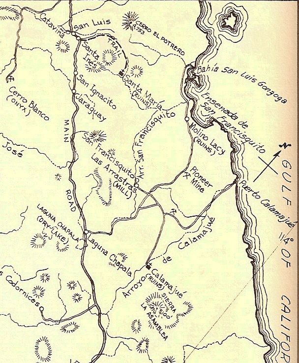
The one south from Molino de Lacy that passes the Pioneer Mine?


I traveled only a couple miles of it in 2002... was more of a motorcycle route. Back in the late 1950s, it was a preferred route over the deep sand track along Arroyo San Francisquito.

From 1956:


David K - 3-8-2016 at 07:01 PM

This photo was taken from the hill at Molino de Lacy... facing south. The road going south, right of my truck, along the right side of the photo, is it...


willardguy - 3-8-2016 at 07:10 PM

but i've seen no evidence of it continuing over the mountain?

David K - 3-8-2016 at 10:22 PM

Quote: Originally posted by willardguy  
but i've seen no evidence of it continuing over the mountain?

By anything bigger than m/c anymore you mean?

willardguy - 3-8-2016 at 10:25 PM

Quote: Originally posted by David K  
Quote: Originally posted by willardguy  
but i've seen no evidence of it continuing over the mountain?

By anything bigger than m/c anymore you mean?


who's done it on a scoot?

David K - 3-8-2016 at 11:51 PM

Quote: Originally posted by willardguy  
Quote: Originally posted by David K  
Quote: Originally posted by willardguy  
but i've seen no evidence of it continuing over the mountain?

By anything bigger than m/c anymore you mean?


who's done it on a scoot?


Kacey Smith from Alfonsina's... it's in her book... plus all the tracks I saw.

motoged - 3-9-2016 at 12:08 AM

I think Kacey calls it The Mine Trail...

David K - 3-9-2016 at 12:19 AM

Quote: Originally posted by motoged  
I think Kacey calls it The Mine Trail...


Yes, as it was how the ore got from the Pioneer Mine to Molino San Francisquito (Molino de Lacy today)... and that was not using motorcycles!

It was a very tough road in the 60's and 70s... Mike Humfreville even wrote a chapter about it when he drove it in his Land Cruiser!: http://math.ucr.edu/ftm/bajaPages/Correspondents/MikeHumfrev...

4x4abc - 3-9-2016 at 04:40 AM

it's a medium difficult 4x4 road
I have done it more times than I can count
last time in May 2014
some cool mining stuff out there
https://carlosnpainter.smugmug.com/Events/Manly-Men-Baja-201...


Phil S - 3-9-2016 at 05:26 AM

wouldn't want to be traveling during an earthquake in this area (last pic) Interesting route. Don't think I'd want to venture here in my Yukon XLT, even though I love 'tough' routes. This looks too challenging. What do you mean, 4x4, regarding the mine reference? "stuff" Any pic's of the 'stuff'.? Would love to see them here. (save me a trick attempt)

David K - 3-9-2016 at 09:06 AM

Quote: Originally posted by Phil S  
wouldn't want to be traveling during an earthquake in this area (last pic) Interesting route. Don't think I'd want to venture here in my Yukon XLT, even though I love 'tough' routes. This looks too challenging. What do you mean, 4x4, regarding the mine reference? "stuff" Any pic's of the 'stuff'.? Would love to see them here. (save me a trick attempt)


Starting here at Punta Final, then click on the right arrow to advance through the photos of the road and mine: https://carlosnpainter.smugmug.com/Events/Manly-Men-Baja-201...

StuckSucks - 3-9-2016 at 11:09 AM

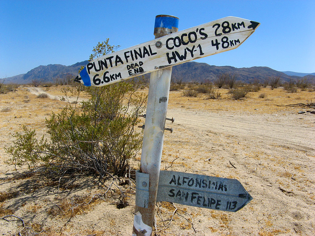
This was taken 10 years ago, but I believe this was at the intersection of the road from Punta Final to Highway 5, and that "straight" north/south road (south of Molina Lacy).


4x4abc - 3-9-2016 at 02:58 PM

love those old Baja road signs

the most creative is probably the Santa Barbara/San Miguel sign at La Junta


[Edited on 3-9-2016 by 4x4abc]

[Edited on 3-9-2016 by 4x4abc]

toronja - 3-9-2016 at 04:42 PM

Cool beans, guys, thanks for the mini tour. We are not quite that adventurous in the 4x4 department (working with a steadfast but bulky Chevy trailblazer here). I'm curious if one attempted a round trip from the north side to the mine and back, would that be a little less hairy? Or is the mine and road north still in pretty rough terrain?

willardguy - 3-9-2016 at 04:50 PM

now im really lost...I thought we WERE talking about going in from the north?

toronja - 3-9-2016 at 04:56 PM

Ah crap, no that was my bad, Willard. The first couple of comments were regarding from the south and I just got all bamboozled. I guess my question would thus be the reverse - from the south to the mine and back.

willardguy - 3-9-2016 at 05:08 PM

I could be wrong...but what I've assumed is the other end (calamajue road junction) has mining going on and guards on duty, that you can see from the calamajue road. this within the last couple years.

David K - 3-9-2016 at 05:08 PM

Quote: Originally posted by toronja  
Ah crap, no that was my bad, Willard. The first couple of comments were regarding from the south and I just got all bamboozled. I guess my question would thus be the reverse - from the south to the mine and back.


Why not just make a loop... much of the west side is now paved, however.

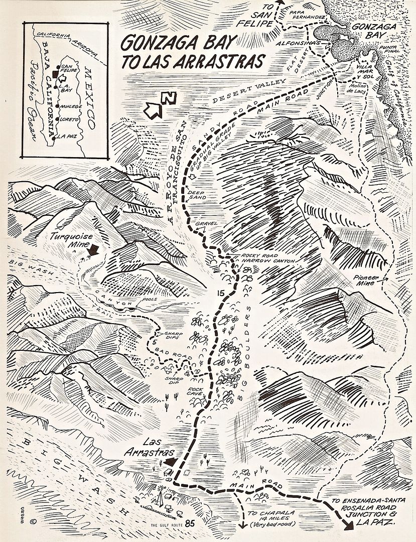
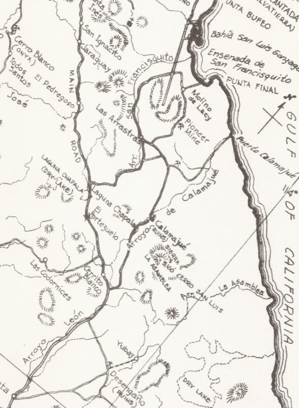
Note "Pioneer Mine" on the east side road. Look at 4x4abc's photos to see the road and 4 wheeled vehicles on it...


Map by Cliff Cross, 1970

David K - 3-9-2016 at 05:13 PM

Google Earth is your trip planning friend... Bing Maps has even newer satellite images of many areas.

Timothy Walker found dynamite in a shed near the south end of the road at one of the (then) semi-active gold mines. While TimsBaja.com is no longer on the Internet, I have all his trip pages saved and can show them if interested. Tim and his friends Robert and Robert did a lot of exploring around Coco's Corner and Gonzaga Bay 10-15 years ago.

PaulW - 3-9-2016 at 05:26 PM

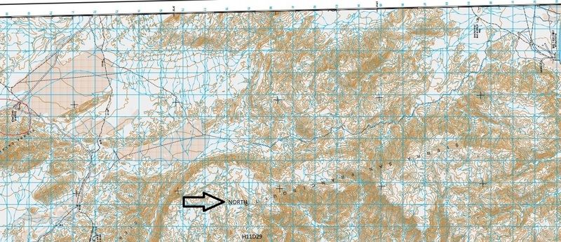
INEGI Topo Image
Road near Coco’s to Punta Final


toronja - 3-9-2016 at 05:33 PM

I did check out 4x4abc's photos, David. From that sequence, we would not be comfortable tackling the rocky stretches between Punta Final and the mine... There were not any particularly gnarly photos in the photo set after the mine visit, so my question was whether the south end of the road was less difficult. Or perhaps the photos after that are of the west side of the loop before paving? I couldn't tell where they ended their journey.

Paul's topo map section

David K - 3-9-2016 at 05:42 PM

That's the same road as in the maps I posted and in Harald's photos. It is 14.4 miles from Molino de Lacy south to the original Puerto Calamajué/ Las Arrastras road, according to Howard Gulick in the 1958 edition of his Lower California Guidebook... when the Pioneer Mine road was the main road south from Gonzaga Bay (in 1956), although the west side of the mountain road was also open then.

[Edited on 3-10-2016 by David K]

David K - 3-9-2016 at 05:47 PM

Quote: Originally posted by toronja  
I did check out 4x4abc's photos, David. From that sequence, we would not be comfortable tackling the rocky stretches between Punta Final and the mine... There were not any particularly gnarly photos in the photo set after the mine visit, so my question was whether the south end of the road was less difficult. Or perhaps the photos after that are of the west side of the loop before paving? I couldn't tell where they ended their journey.


You would be correct that the south road in and out of the Pioneer Mine would be the easier route. The Pioneer to Molino de Lacy section must be the rockier, more deserted section. When I headed south of Molino de Lacy in 2002, I traveled 2.5 miles before the rocks got big enough to drive over slowly, I turned around to spend more time exploring other areas.

[Edited on 3-10-2016 by David K]

4x4abc - 3-9-2016 at 05:57 PM

the south end of the Pioneer mine road is super easy

the new gold mine is no longer new and now abandoned

even when it was active, it did never block the Pioneer mine road

toronja - 3-9-2016 at 06:02 PM

Thanks, gentlemen! I hope we get the chance to give it a try next time we're down, we haven't explored that area much.

PaulW - 3-9-2016 at 06:14 PM

Wow, such an interesting thread. I guess I will have to head down there and check out the roads. For sure its is more interesting than the paved road these days.
If the pavement gets a little further south maybe we can find the Turquesia road turn off? If anyone finds it please post the coordinates.

David K - 3-9-2016 at 06:40 PM

Quote: Originally posted by PaulW  
Wow, such an interesting thread. I guess I will have to head down there and check out the roads. For sure its is more interesting than the paved road these days.
If the pavement gets a little further south maybe we can find the Turquesia road turn off? If anyone finds it please post the coordinates.


Paul, I have posted it...

Here you go, where La Turquesa Canyon road meets dirt Hwy. 5 (not necessarily the paved route when it reaches this point): 29º34.36', -114º22.01'

PaulW - 3-9-2016 at 06:49 PM

Quote: Originally posted by David K  
Quote: Originally posted by PaulW  
Wow, such an interesting thread. I guess I will have to head down there and check out the roads. For sure its is more interesting than the paved road these days.
If the pavement gets a little further south maybe we can find the Turquesia road turn off? If anyone finds it please post the coordinates.


Paul, I have posted it...

Here you go, where La Turquesa Canyon road meets dirt Hwy. 5 (not necessarily the paved route when it reaches this point): 29º34.36', -114º22.01'

====
No, the new road erases your place. We need a new place. I could not even find the traditional coords. Lots pf changes thereabouts.

David K - 3-9-2016 at 06:52 PM

Well... you just need to find a way off the new road once it reaches that area and it will be very close, naturally. The fun part is if they put up the stupid barb wire fence along both sides blocking all existing side roads from the highway.

BajaRat - 3-9-2016 at 07:48 PM

Quote: Originally posted by PaulW  
Quote: Originally posted by David K  
Quote: Originally posted by PaulW  
Wow, such an interesting thread. I guess I will have to head down there and check out the roads. For sure its is more interesting than the paved road these days.
If the pavement gets a little further south maybe we can find the Turquesia road turn off? If anyone finds it please post the coordinates.


Paul, I have posted it...

Here you go, where La Turquesa Canyon road meets dirt Hwy. 5 (not necessarily the paved route when it reaches this point): 29º34.36', -114º22.01'

====
No, the new road erases your place. We need a new place. I could not even find the traditional coords. Lots pf changes thereabouts.


Me and The Fam had a heck of a time locating the access road to La Turquesa last Nov after the new concrete under hwy drains were poured. The original access started in an arroyo which is now an overpass. A new track will have to be cut down the edge of the arroyo from the North after nipping the fence up on the flat. Gonna take some time unless someone can convince the construction crew to do a 20 min D9 project before they move on. Just some of the sad casualties of the hwy 5 paving project.

Lionel :cool:

spikemd - 3-15-2016 at 01:03 PM

Looks like a cool road. Heading to Punta Final in a few weeks. Are the mines worth exploring? We will have a group of land rovers looking for some adventures.

StuckSucks - 3-15-2016 at 02:34 PM

Here's a photo sphere I took next to the turn-off to the turquoise mine on Highway 5.

PaulW - 3-15-2016 at 03:45 PM

Boy it sure does not look like that now.

willardguy - 3-15-2016 at 04:09 PM

Quote: Originally posted by StuckSucks  
Here's a photo sphere I took next to the turn-off to the turquoise mine on Highway 5.


it used to be marked by a car hood....man that camera shot that you can pan around and in and out is sure swanky! :yes:

norte - 3-15-2016 at 06:40 PM

Quote: Originally posted by David K  
Well... you just need to find a way off the new road once it reaches that area and it will be very close, naturally. The fun part is if they put up the stupid barb wire fence along both sides blocking all existing side roads from the highway.


Hey I figured you for a property rights kind of guy. Are you only a conservative when you are in the States? Fencing in private property is a right, not a privilege.

TMW - 3-15-2016 at 06:48 PM

The fence along the side of the highway is not a private property issue. If there are roads to private property the state or feds will let you cut the wire for access, or they will do it. I think the fence is to keep large animals off the Hwy, like cows.

David K - 3-15-2016 at 06:50 PM

A paved road doesn't magically turn the desert into private property. In fact, the fence blocks any property owners from accessing their land. So, for the respect of land owners and taxpayers alike: Mr. Highway builder, tear down this fence!

rts551 - 3-15-2016 at 07:29 PM

Quote: Originally posted by David K  
A paved road doesn't magically turn the desert into private property. In fact, the fence blocks any property owners from accessing their land. So, for the respect of land owners and taxpayers alike: Mr. Highway builder, tear down this fence!


Taxpayers? land owners? which are you to make this demand?

For your info, most of the land on either side of the road is Private Property. Some to ranches. Some to Ejidos. Some to large land developers.

As states above by TMW, if the Landowner, and only the landowner, wishes to put in a gate they are allowed to.

In this case, Norte has it right. What right do you have to trespass?

bajatrailrider - 3-15-2016 at 08:08 PM

Again RTS and Nerdy the real estate lawyers.Give it a rest , baja works little different. Everywhere in baja,when the state.Builds a new fence. They block old existing roads,somehow they get gates. Just a fact of life.What right do you have to call anybody trespasser. You don't own it now do you.

rts551 - 3-15-2016 at 08:17 PM

Quote: Originally posted by bajatrailrider  
Again RTS and Nerdy the real estate lawyers.Give it a rest , baja works little different. Everywhere in baja,when the state.Builds a new fence. They block old existing roads,somehow they get gates. Just a fact of life.What right do you have to call anybody trespasser. You don't own it now do you.


Again, you make no sense. What is different about private property in Baja? Yes...the state can build a fence along the highway and people can build a fence around their property (at least you got that right). I don't have to own the property to know - If you go on someones property uninvited, you are trespassing. What about that do you not understand?

Tomas Tierra - 3-15-2016 at 08:21 PM

Haters gonna hate

rts551 - 3-15-2016 at 08:25 PM

Hate? I just don't see anything wrong with the highway being separated from private property. a foreigner demanding to cross that property...now that's hate.

bajatrailrider - 3-15-2016 at 09:25 PM

Your the foreigner,that is telling people. Who you think,is demanding to cross property. Now that's hate.Again I ask you and Nerdy.What is it your business,since your a foreigner. Its none of your business.Your not the police,your not the land owner.Your not Mexican.Your a bed wetter,along with MT6.In his case,he just needs diaper changing. So your gonna change the world,with your.Thinking your still in the US.Welcome to baja. The three of you,wont change anything with your worthless posts. I do enjoy them,Save the world.Maybe try another country.

4x4abc - 3-15-2016 at 09:29 PM

wow - that went ugly fast. Is hate the new christian mantra? What happened to Jesus with all that peace stuff?

bajatrailrider - 3-15-2016 at 09:42 PM

I have zero tolerance, for TWs in off road forum.(Time wasters) .After wheeling with you nomads the first time.Seeing how your great people.All get along,then the stupid posts.From non off road people. The three need to put there politics,in that forum.Hope to wheel with you again Harold.

Bajaboy - 3-15-2016 at 10:19 PM

Quote: Originally posted by David K  
A paved road doesn't magically turn the desert into private property. In fact, the fence blocks any property owners from accessing their land. So, for the respect of land owners and taxpayers alike: Mr. Highway builder, tear down this fence!


So you're against the fence but support building a wall:light:

Barry A. - 3-15-2016 at 10:54 PM

Quote: Originally posted by Bajaboy  
Quote: Originally posted by David K  
A paved road doesn't magically turn the desert into private property. In fact, the fence blocks any property owners from accessing their land. So, for the respect of land owners and taxpayers alike: Mr. Highway builder, tear down this fence!


So you're against the fence but support building a wall:light:


Apples and oranges------------and a red herring to boot-----------yes, "haters just hate", it's in their DNA, I believe.

rts551 - 3-15-2016 at 11:03 PM

As some here know (obviously not every one), I do own property in Baja Sur and am a resident of Mexico. What I am amazed at is, how some, not all, would understand why a fence could be built around private property. Its not about Hate...Its about how some seem to believe anything goes in Mexico. Sorry folks, its not a lawless country. Does being on Nomads give someone some secret power or just a blatant ignorance.

Barry A. - 3-15-2016 at 11:13 PM

Quote: Originally posted by rts551  
As some here know (obviously not every one), I do own property in Baja Sur and am a resident of Mexico. What I am amazed at is, how some, not all, would understand why a fence could be built around private property. Its not about Hate...Its about how some seem to believe anything goes in Mexico. Sorry folks, its not a lawless country. Does being on Nomads give someone some secret power or just a blatant ignorance.


As someone mentioned before, the "fences" along highways are built to prevent large animals from being on the highway-----not to keep vehicles from exiting or entering the highway. Logically, it seems to me that simple gates could be installed in these fences where existing roads are found, and that would solve any of these problems. "Private land" is seldom the issue in my experience, either in Mexico, or the USA in the west.

The "hate" I refer to is the vicious non-sense attacks on people having different opinions--------which accomplishes nothing.

bajatrailrider - 3-16-2016 at 07:11 AM

This is very true,the fences are to prevent.Live stock from crossing road. Not to stop vehicles. Every time some one shows,a map here.Then the three knuckle heads.Are not posting opinions,there posting. How to be a control freak. As far as RT, I'm a resident too.Also own many property's,and rancho. That does not give me the right to tell someone.How and where I think they should go. Oh yea my rancho,has unlocked gates both ends. Just to inform you,the military.Comes past every rancho here once a year. You lock your gate.They climb over fence, (yes on your property). If they cant locate someone to open locked gate. They drive right over your fence. So to compare,Baja to the U.S , is more of a joke then anything else. This is a off road forum, not your play ground.To state,who can and cannot. You don't like the attacks,Start a new post.Control Freaks. Also yes I do hate control freaks, they will be answered.

spikemd - 3-16-2016 at 07:46 AM

Back to my original question and pertaining to the topic at hand, which mines are worth exploring in the area around Cocos corner and Punta Final?

norte - 3-16-2016 at 09:06 AM

Wow. Did not mean to bring Trump's son into the fray with his incomplete sentences and name calling. He does show what is wrong with some off-roaders...He thinks he has the same right to cross property as the military does.

bajatrailrider - 3-16-2016 at 05:28 PM

Give it up Nerdy,Trump is your buddy not mine.You will get name calling.As long as you post Brainless posts. I never said, I cross same right as Military. Your nobody to post,Where people can go. Unless its your property.Is this your property,where they show on the Map. Are you a Mexican Lawyer.Are you in a foreign country. You three marooons only here to disrupt Off road forum. So that's the name calling you get. Direct all your attention to me,then the rest.Does not need to hear,If you approve. I Also forgot are you the Land police of Mexico,think not.Then shut up.

PaulW - 2-4-2018 at 11:53 AM

DavidK wrote:

Paul, I have posted it...

Here you go, where La Turquesa Canyon road meets dirt Hwy. 5 (not necessarily the paved route when it reaches this point): 29�34.36', -114�22.01'[/rquote]
==== ==
For completeness read:
I believe without driving the road to La Turquesa Canyon, this link tells the turn off at/on the new road on the north side of the new bridge.
http://forums.bajanomad.com/viewthread.php?tid=88271
Anyway, hardly any difference from the old coordinates.

PaulW - 2-4-2018 at 12:06 PM

Back on the original subject I just drove the road in question going South over the summit past the Pioneer mine thru Calamajue and I will post my tracks later. Rich T. led four other Jeeps for this trip. One more desirable road to check off my list.
To summarize the road (wash) North of the summit is heavily overgrown and the rocks are large requiring careful tire placement. Lockers were not needed, but all of us used 4Lo most of the way. After the summit all the way to El Crucero was easy driving. It was a long day starting in San Felipe later than desired - dark at El Crucero. Very shallow puddles in Calamajue.

[Edited on 2-5-2018 by PaulW]

TMW - 2-4-2018 at 06:42 PM

The last time I was at the Turquesa Mine road jct along Hwy 5 the turn off was at the northwest corner of the bridge. Easy to drive down at the GPS coordinates shown above.

PaulW - 2-6-2018 at 10:31 AM

Quote: Originally posted by PaulW  
Back on the original subject I just drove the road in question going South over the summit past the Pioneer mine thru Calamajue and I will post my tracks later. Rich T. led four other Jeeps for this trip. One more desirable road to check off my list.
To summarize the road (wash) North of the summit is heavily overgrown and the rocks are large requiring careful tire placement. Lockers were not needed, but all of us used 4Lo most of the way. After the summit all the way to El Crucero was easy driving. It was a long day starting in San Felipe later than desired - dark at El Crucero. Very shallow puddles in Calamajue.

[Edited on 2-5-2018 by PaulW]

==== =
Continuing
Trip description for Pioneer Mine Road First day of a 5 day edventure
Day 1 - 1/18/2018
Our leader was Rich T. He had done the trip before and had a correct GPS track. San Felipe to Hwy5K156 to begin the Pioneer Mine road heading South thru Calamajue and El Crucero then to LAB

Started in San Felipe and drove the highway to just south of Gonzaga. Then drove east to the subject road which is a track between Hwy1 and Punta Final via El Crucero / Calamajue. Spent night in a hotel in LAB.
The road on the north side of the mountain was difficult. It was way overgrown with heavy bushes. Did not need lockers but used 4Lo mostly and 15 psi for my rig. Huge rocks to drive over. Everybody made it thru ok. Rigs were my Unlimited TJ with 35†tires. Rich’s CJ rock crawler with 39†tires and stretched wheel base. Two late model JK 4 door rigs, one with 33†and the other with 37â€. One TJ with 33†tires. These guys are very experience their rock crawling days (In other rigs). Lots of new scratches on all rigs. I searched many sources and could not find a decent depiction to the road we took. We now have it with my tracks on GE as well as GPS tracks
Details: Leave Hwy5 at ~K156 and head east along good roads to the start of the trail. Arrive at El Crucero at Hwy 1 at K261 after dark.
Here are my collection of maps for the day:

Google Earth image


From my Inreach with 10 minute data points


Attached is a GPS file. Load it into Google Earth for details or desired closeup.


Attachment: Trail 2 Revised Day 1 H5-Lab Rd.usr (80kB)
This file has been downloaded 325 times

David K - 2-6-2018 at 10:54 AM

Beautiful! Do you have photos of the Pioneer Mine or other sites, please?

Ken Cooke - 7-15-2018 at 10:01 PM

Reviewing for IMPOSSIBLE 2019 run

geoffff - 7-16-2018 at 03:02 PM

Here is PaulW's track as a GPX file:

Trail-2-Revised-Day-1-H5-Lab-Rd.gpx

-- Geoff

David K - 7-16-2018 at 03:11 PM

geoffff, can you try with another format maybe? I get a 'can't open' message from Adobe when I click that link?

geoffff - 7-16-2018 at 03:30 PM

It's a GPX file, used by Garmin apps, and can also be dragged into Google Earth.

In any case, here it is again converted into Google Earth format:

Trail-2-Revised-Day-1-H5-Lab-Rd.kml

-- Geoff

TMW - 7-16-2018 at 04:17 PM

Thanks for both files. When I converted Paul's file to GE file I got several straight red lines. It showed the mine road but the red lines didn't look good.

David K - 7-16-2018 at 04:19 PM

Quote: Originally posted by geoffff  
It's a GPX file, used by Garmin apps, and can also be dragged into Google Earth.

In any case, here it is again converted into Google Earth format:

Trail-2-Revised-Day-1-H5-Lab-Rd.kml

-- Geoff


Yes, the KML file works fine, opens up in Google Earth. Thanks!
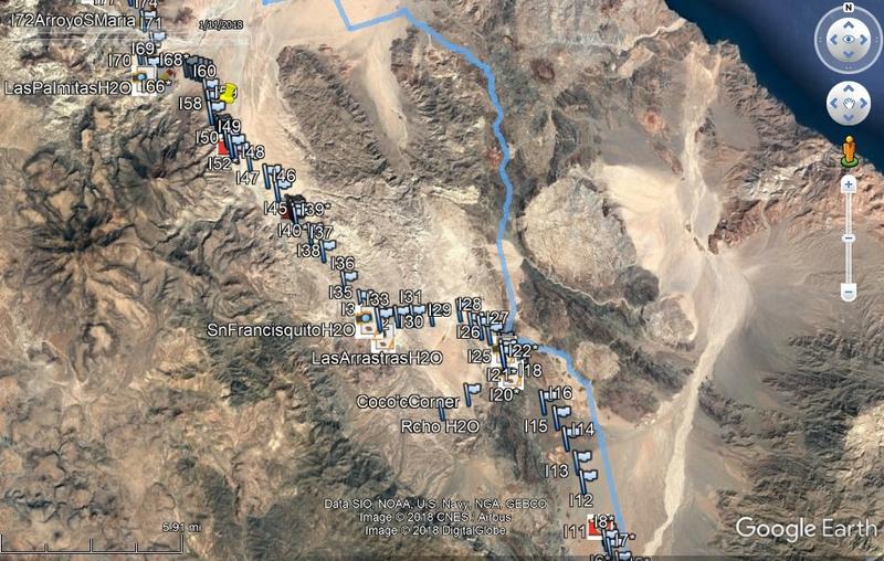
Here is the route (blue line) on my Google Earth which has the El Camino Real waypoints included (all the numbered marker flag pins) from www.caminorealbaja.com :


PaulW - 7-16-2018 at 04:34 PM

That is the first file with no WPs
==== =

Quote: Originally posted by geoffff  
Here is PaulW's track as a GPX file:

Trail-2-Revised-Day-1-H5-Lab-Rd.gpx

-- Geoff

Ken Cooke - 7-16-2018 at 04:56 PM

Quote: Originally posted by 4x4abc  
it's a medium difficult 4x4 road
I have done it more times than I can count
last time in May 2014
some cool mining stuff out there
https://carlosnpainter.smugmug.com/Events/Manly-Men-Baja-201...


Looks doable for a small-sized group during one day. Should be fun!:bounce: