BajaNomad

Road from the states open yet

Keri - 5-3-2016 at 05:24 PM

or do we still have to detour,k

Howard - 5-3-2016 at 05:33 PM

If you are talking about the toll road, it's all completed with no detour.

bajaguy - 5-3-2016 at 06:21 PM

Crossing south at San Ysidro??


Quote: Originally posted by Keri  
or do we still have to detour,k

Keri - 5-3-2016 at 07:33 PM

Yes going to ensenada,k

BajaGeoff - 5-5-2016 at 03:22 PM

The detour is still there Keri. I crossed south yesterday...

Udo - 5-5-2016 at 03:57 PM

I still don't know what road Keri is talking about. There are a dozen roads going south that head to Ensenada.

BajaGeoff - 5-5-2016 at 03:59 PM


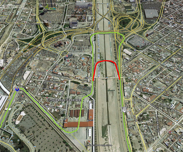
Here is a map of the detour. The green line shows the best route to use when coming from 5 south crossing in to Mexico. Once you get across the border, go straight and up on to the second bridge that crosses over the river, then merge down on to the international road that parallels the border heading west. The red line shows the normal route over the first bridge that is currently closed for construction. Hope this helps!

[Edited on 5-5-2016 by BajaGeoff]

woody with a view - 5-5-2016 at 04:15 PM

that red bridge needs to be fixed!

Alm - 5-5-2016 at 04:25 PM

I tried going this way once, by mistake. Toll road was open, I knew that the right-most lane was the way to go but they pulled me over for inspection into the left-most lane. With crazy Mex traffic at 5 pm it wasn't possible crossing from the left-most to the right-most lane on a dozen feet distance btw Aduana and Mex 1 entrance, so I went straight as the green line goes, then turned right.

Shortly after that, there was another fork, totally unreadable against setting sun - you know their skills in traffic signage, right? So I took the wrong turn and ended up meandering through - probably - Playas Tijuana. For a dump like Tijuana this isn't too bad district, I have to say. But the on-ramp from "playas" to Mex 1 is not like your regular on-ramp. There was "something" - don't know what - either speed bump or a pothole few feet deep. So, if you happen to be there, don't accelerate through the on-ramp like you normally would :)

skipowell - 5-5-2016 at 07:56 PM

The in bound mexico detour is really no big deal, might add three minutes to total trip. Fortunately they re-opened the east bound road quickly after having it closed initially for about a week that one was a bit more of a detour, or trek through TJ

mtgoat666 - 5-5-2016 at 10:01 PM

Quote: Originally posted by Keri  
or do we still have to detour,k


Go west on 3rd, then get over on to 2nd. 2nd becomes the toll road.

BajaMama - 5-6-2016 at 06:41 AM

I am crossing into Mexico through San Ysidro May 22 - are the detour signs marked pretty well? it does't look too bad.

SFandH - 5-6-2016 at 08:05 AM

Quote: Originally posted by mtgoat666  
Quote: Originally posted by Keri  
or do we still have to detour,k


Go west on 3rd, then get over on to 2nd. 2nd becomes the toll road.


That's an option if you know your way around but no need to do that anymore, at least not for now. Follow the green road in the above graphic. It takes you back to the old route (bridge) to the westbound border highway used before they built the new southbound crossing.


[Edited on 5-6-2016 by SFandH]

David K - 5-6-2016 at 08:11 AM

Geoff, for us guys who are red/green color blind... is the "green line" the one that first turns right after entering Mexico and goes over the river, or the second one that goes over the river? Hard to tell what color those two are (if red or green).

Thank you!
(actually, anyone who can tell can answer):light:

TMW - 5-6-2016 at 08:23 AM

It's the second one DK or the one on top, the first one is the red line.

David K - 5-6-2016 at 08:36 AM

Thanks, Tom... to me, they look only a little different, either reddish or greenish but can't tell which is one vs. the other!

BajaGeoff - 5-6-2016 at 10:36 AM

As an additional reference point, the second bridge that goes over the river is the same bridge you used to go over and exit to the right to head west on the international road...this was before they put in the new border crossing.

David K - 5-6-2016 at 11:03 AM

Thanks Geoff... and for the color-blind Baja travelers, blue and yellow are great track colors on maps, but not red and green or purple and dark blue (to tell them apart on the same map).

BajaGeoff - 5-6-2016 at 02:26 PM

Hehe..good to know DK!

I was going for "green means go" and "red means no" when I made the map.

mtgoat666 - 5-6-2016 at 03:50 PM

Quote: Originally posted by David K  
Thanks Geoff... and for the color-blind Baja travelers, blue and yellow are great track colors on maps, but not red and green or purple and dark blue (to tell them apart on the same map).


Instead of relying on colors, you should vary line weight or type (solid, dashed, etc) to distinguish different lines.
If you work to be understood in B&W, you can then print in B&W, and save money on ink cartridges :lol:

David K - 5-6-2016 at 04:08 PM

Quote: Originally posted by mtgoat666  
Quote: Originally posted by David K  
Thanks Geoff... and for the color-blind Baja travelers, blue and yellow are great track colors on maps, but not red and green or purple and dark blue (to tell them apart on the same map).


Instead of relying on colors, you should vary line weight or type (solid, dashed, etc) to distinguish different lines.
If you work to be understood in B&W, you can then print in B&W, and save money on ink cartridges :lol:


Finally, something from goat that is both smart and conservative! :light::lol: