BajaNomad

Secret Track Between Playa Costilla & Hwy 1?

salttram - 12-3-2016 at 02:06 PM

At 1PM on 12/3/16 maybe not so secret anymore!

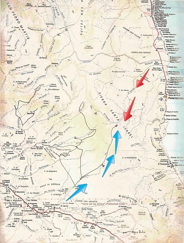
In my Google Earth ramblings, I found a track that connects Hwy 5 near Playa Costilla to Hwy 1 near Guayaquil. This may be the Holy Grail for those of us who have always wished for a way to drive from the Cataviña area to the Cortez, without the difficulty of the La Turquesa route.

Looks like pretty good 2-track most of the way, passing some cool-looking mines, palm canyons, and some interesting mesas. The only troublesome stretch looks like a short stint in a narrow wash connecting the good-looking 2-track on either side.

Planning to give it a whirl on our trip next month . . has anyone tried this? Should I shut up about it, delete this post and keep it to myself?

[Edited on 12-3-2016 by salttram]

Barry A. - 12-3-2016 at 02:25 PM

That route is very iffy, if it even goes thru. I am sure somebody will address your questions as it has been discussed before. It would be great if possible, but I am not optimistic, even for motorcycles.

salttram - 12-3-2016 at 02:46 PM

It looks pretty good to me . . . except maybe the one section I mentioned. I've found some other secret routes on GE that were much more sketchy-looking . . . but they delivered the goods for me and my near-stock Tacoma!

[Edited on 12-3-2016 by salttram]

Barry A. - 12-3-2016 at 02:56 PM

I do hope that you are right----------it would be wonderful to have a route thru there, like you say, and maybe somebody has recently pioneered one through. I know all the country north and south of there, but have not explored to the west along that particular set of washes and arroyos, south of the Matomi. Things do change as the storms come thru.

mtgoat666 - 12-3-2016 at 03:11 PM


Can't you be happy leaving a little bit of land wild and roadless?

Baja would be a boring place if you knuckledraggers plowed roads into every undeveloped area.

Barry A. - 12-3-2016 at 03:30 PM

Quote: Originally posted by mtgoat666  

Can't you be happy leaving a little bit of land wild and roadless?

Baja would be a boring place if you knuckledraggers plowed roads into every undeveloped area.


When was the last time you hiked/backpacked into that area that we are speaking of between Hyway 5 and Hyway 1, Goat?

My guesstimate is that 95% of Baja is still "wild and roadless" so I don't think you need to panic yet, let alone insult you fellow NOMADS. (but that IS what your purpose in life on NOMADS appears to be)


salttram - 12-3-2016 at 03:33 PM

Wild and roadless land makes me happier than anything! I would never pioneer a route with anything other than hiking boots.

I was just saying that most of this route is quite clearly a road. After looking around BN here a bit, I see this is the Bill Nichols Trail? I thought that was M/Cs only.

salttram - 12-3-2016 at 03:41 PM

There are already too many roads!

David K - 12-3-2016 at 04:38 PM

That is the approx. route of the Bill Nichols Trail... and yes, not for four wheels on at least the part where it climbs up not far from the mine area south of La Costilla.

We would love a 4WD short cut from Puertecitos to El Rosario/Cataviña area. Think of how much better it would be for the environment with less fossil fuel consumed going over 100 miles extra!

I explored some unmapped roads north of El Mármol and found a drug runway, but the road didn't go to the divide.

The La Olividada barite mine people (east of El Mármol and past El Volcán) had told a Nomad that the mine company was going to continue their new graded road on down the mountain to Hwy. 5 (south of El Huerfanito). The mine is on the gulf side of the peninsular divide.

On Google, you can follow a unmapped graded road (blue arrows) to some mine operation from El Aguila (near Guayaquil/ San Agustin) almost to Puertecitos! Alas, just a cliff and rocky Arroyo El Canelo (red arrows) prevents driving through... we can only hope!


TMW - 12-3-2016 at 06:06 PM

After Bajalou's last turkey feast I tried going down arroyo El Canelo on my XR250 but the sand was too soft maybe a KX500 might get thru.

Bajalou also tried it in a buggy and could not get thru due to the large rocks. The Bill Nichols trail is good for 2 wheel MCs but I'm told there is one section thru a narrow canyon that an ATV would not get thru.

BajaRat - 12-3-2016 at 08:10 PM

Quote: Originally posted by salttram  
At 1PM on 12/3/16 maybe not so secret anymore!

In my Google Earth ramblings, I found a track that connects Hwy 5 near Playa Costilla to Hwy 1 near Guayaquil. This may be the Holy Grail for those of us who have always wished for a way to drive from the Cataviña area to the Cortez, without the difficulty of the La Turquesa.

[Edited on 12-3-2016 by salttram]


Are we talking the La Turquesa mine south of Rancho Grande ?

bajatrailrider - 12-3-2016 at 08:32 PM

Quote: Originally posted by mtgoat666  

Can't you be happy leaving a little bit of land wild and roadless?

Baja would be a boring place if you knuckledraggers plowed roads into every undeveloped area.
Another post from Old Baja Blow hard the village idiot strikes again give it up MT... Yes Bill Nichols trail is moto only also not easy. You need skill,endurance,guts Witch Blow hard Mt has none,just a silly tourist that has zero knowledge of Baja.:?:

bezzell - 12-3-2016 at 09:07 PM

Quote: Originally posted by bajatrailrider  
Quote: Originally posted by mtgoat666  

Can't you be happy leaving a little bit of land wild and roadless?

Baja would be a boring place if you knuckledraggers plowed roads into every undeveloped area.
Another post from Old Baja Blow hard the village idiot strikes again give it up MT... Yes Bill Nichols trail is moto only also not easy. You need skill,endurance,guts Witch Blow hard Mt has none,just a silly tourist that has zero knowledge of Baja.:?:


ohh, here we go ... the Snake Whisperer is gonna advise others how to behave in the desert!
now THAT's rich

David K - 12-3-2016 at 09:08 PM

Quote: Originally posted by BajaRat  
Quote: Originally posted by salttram  
At 1PM on 12/3/16 maybe not so secret anymore!

In my Google Earth ramblings, I found a track that connects Hwy 5 near Playa Costilla to Hwy 1 near Guayaquil. This may be the Holy Grail for those of us who have always wished for a way to drive from the Cataviña area to the Cortez, without the difficulty of the La Turquesa.

[Edited on 12-3-2016 by salttram]


Are we talking the La Turquesa mine south of Rancho Grande ?


I think so, as it is the first auto road between the 1 and the 5 heading south, but difficult. Just ask Roy The Squarecircle and TW who helped Roy get through.

bajatrailrider - 12-4-2016 at 08:08 AM

Quote: Originally posted by bezzell  
Quote: Originally posted by bajatrailrider  
Quote: Originally posted by mtgoat666  

Can't you be happy leaving a little bit of land wild and roadless?

Baja would be a boring place if you knuckledraggers plowed roads into every undeveloped area.
Another post from Old Baja Blow hard the village idiot strikes again give it up MT... Yes Bill Nichols trail is moto only also not easy. You need skill,endurance,guts Witch Blow hard Mt has none,just a silly tourist that has zero knowledge of Baja.:?:


ohh, here we go ... the Snake Whisperer is gonna advise others how to behave in the desert!
now THAT's rich
Only Snake Whisperer is your little brain here we go again.:light:

salttram - 12-4-2016 at 08:54 AM

I found the trail on GE while I was looking for a way to drive as close as possible to the more dramatic section of Arroyo Grande.

If there was a road that cut across this area, sure, it would be great and I would check it out. But I don't like the idea of miners (and I do some prospecting), dirt bikers (I love riding dual-sport), or anyone else pioneering roads through virgin territory. That's just me . . . and I hope everyone can have a great time exploring Baja making as little impact as possible. That land south of the border is a great treasure, made greater by its wildness and relative lack of development.

Does anyone know what all those lines across the landscape around the roads north of Guayaquil are for? I'm guessing some kind of low tech placer mining?