BajaNomad

Baja jeep trip 5-12 thru 5-15

ehall - 5-6-2017 at 07:32 AM

Anyone want to join the wife and I for a little sight-seeing trip around Baja Norte. This is her first trip to Baja. She wants to see some of the places I ride my bike too. Loose itinerary.

Cross at Tecate early Friday.
Fri. night Erindira, little fishing off the rocks.
Sat. night Melling , trip to the observatory
Sun. night San Felipe .Thru Mikes, laguna diablo, joses corner.
Cross at Mexicali Monday.

Ken Cooke - 5-6-2017 at 08:05 AM

That sounds like a fun trek around Baja. The weather should be perfect! I have to work, otherwise I would join you.

bajatrailrider - 5-6-2017 at 08:15 AM

I will see if I can join you at least a few days Ed. Need check Dates. It was crazy at El Coyote few days ago Morning 38 daytime 98. Today nice and cool.

ehall - 5-6-2017 at 09:08 AM

That still sounds better than the 108 that it was here yesterday.

ehall - 5-6-2017 at 09:12 AM

That would be great if you want to join us for a day or 2 larry.

bajatrailrider - 5-6-2017 at 09:19 AM

Friday Night will you be at Coyote Cal Could visit you there. In morning would you want to do dirt route up to El coyote. Stay at El Coyote that night. Need reservations.? I have been riding my dirt bikes every week,need a change of pace.

ehall - 5-6-2017 at 10:52 AM

Yes. Made reservations at coyote cals for friday and melling ranch for Saturday. Always up for the dirt route if it will leave us enough time to go up to the Observatory.

David K - 5-6-2017 at 11:29 AM

Guadalupe Canyon Hot Springs may be a fun part of such a trip... lot's of 'Jeep' road and an exotic natural wonder to soak away the bumps!

ehall - 5-6-2017 at 11:43 AM

Quote: Originally posted by David K  
Guadalupe Canyon Hot Springs may be a fun part of such a trip... lot's of 'Jeep' road and an exotic natural wonder to soak away the bumps!


Friends went up there a month or so ago. There reservation was canceled because a lot of the tubs and plumbing were damaged by the rain runoff. Not sure if they are back to 100% yet.

David K - 5-6-2017 at 11:50 AM

10-4... and Elizabeth and I have not been there since Arturo was run out (bought off?) by his nephew's family. It was sure great when it was!

There are other hot springs, but they require hiking... Agua Caliente, Palomar, and Carrizo canyons in the Sierra Juarez east side.

bajatrailrider - 5-7-2017 at 11:15 AM

Quote: Originally posted by ehall  
Yes. Made reservations at coyote cals for friday and melling ranch for Saturday. Always up for the dirt route if it will leave us enough time to go up to the Observatory.
If we leave early morn yes to Observatory visit. I would stay at El coyotes only few miles away,but eat dinner with at Melings. Only because I have free room at Coyotes.:) I also have new unknown (to Most) route from my house all dirt to San Rafael canyon to Melings that can be done in 4x4. Its bush whacking time consuming.

ehall - 5-7-2017 at 12:14 PM

Sounds great. We are having dinner with Tom and Carmina at their house in Punta cabras friday night. After breakfast we will head to San Vicente.

ehall - 5-16-2017 at 08:42 AM

Back from another great trip. It gets harder to leave Baja each time I go.

David K - 5-16-2017 at 09:05 AM

Quote: Originally posted by ehall  
Back from another great trip. It gets harder to leave Baja each time I go.


Photos... or it didn't happen! LOL:D

ehall - 5-16-2017 at 10:52 AM

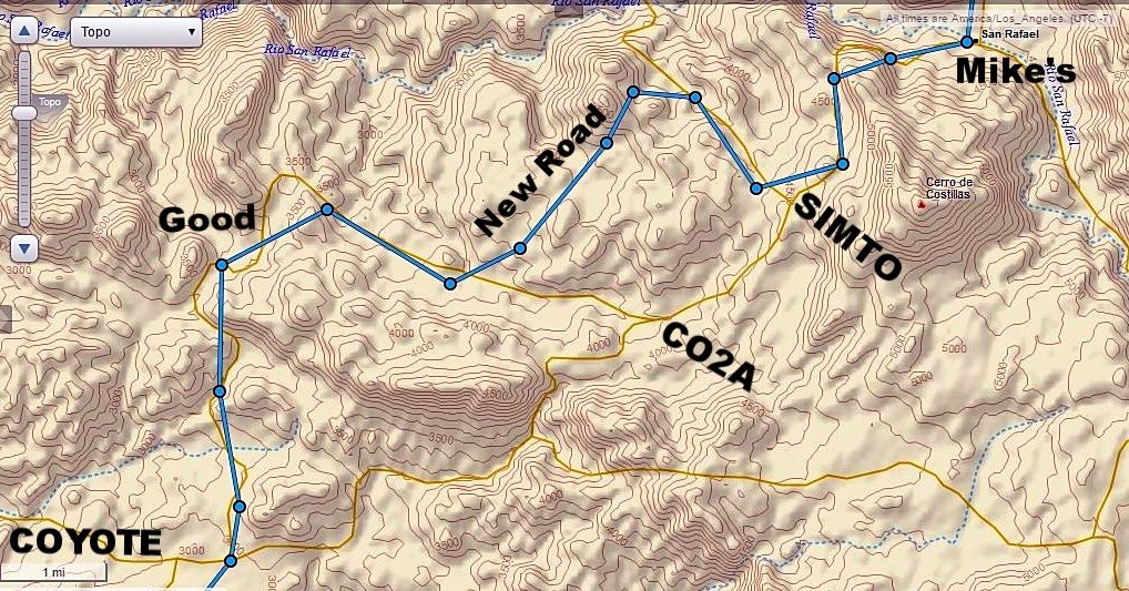
https://share.garmin.com/edhall David. check out the route we took from Coyote to Mikes. The road isn't even on google earth. Missed a turn and went to the ranch in the riverbed. They were building a house and after a beer bribe they opened the pasture gate and let me use the road. I am working on loading some pics to photobucket.

PaulW - 5-16-2017 at 07:34 PM

Quote: Originally posted by ehall  
https://share.garmin.com/edhall David. check out the route we took from Coyote to Mikes. The road isn't even on google earth. Missed a turn and went to the ranch in the riverbed. They were building a house and after a beer bribe they opened the pasture gate and let me use the road. I am working on loading some pics to photobucket.

=====
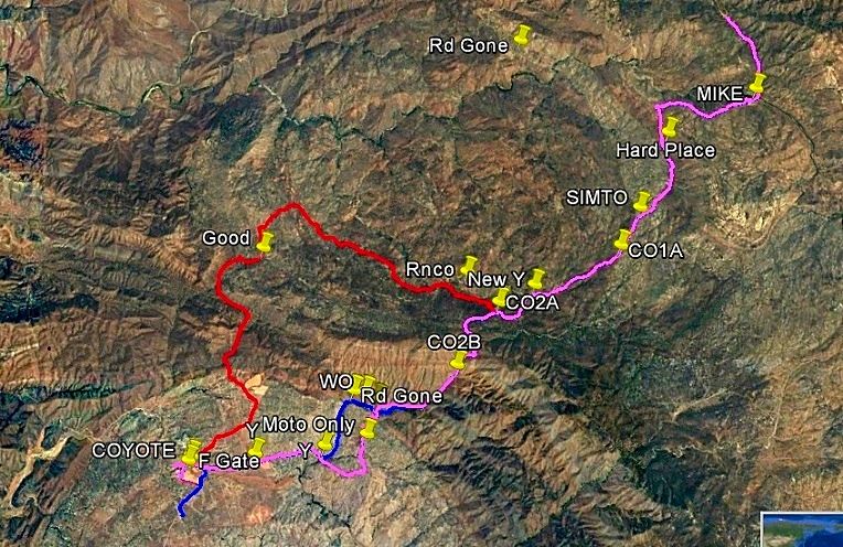
Maybe the bright orange track? Starts at Coyote horse pasture and follows the ranch road then heads up hill to the traditional Mikes road. Freshly bulldozed when I last drove it.
I have a GPS track for all those roads. Ask any U will receive.


Mike 2 Coyote New.jpg - 214kB

ehall - 5-16-2017 at 07:41 PM

Quote: Originally posted by PaulW  
Quote: Originally posted by ehall  
https://share.garmin.com/edhall David. check out the route we took from Coyote to Mikes. The road isn't even on google earth. Missed a turn and went to the ranch in the riverbed. They were building a house and after a beer bribe they opened the pasture gate and let me use the road. I am working on loading some pics to photobucket.

=====
Maybe the bright orange track? Starts at Coyote horse pasture and follows the ranch road then heads up hill to the traditional Mikes road. Freshly bulldozed when I last drove it.
I have a GPS track for all those roads. Ask any U will receive.


Halfway between good and rnco the road went straight north. Right out of the middle of the pasture.

ehall - 5-17-2017 at 04:19 AM

Thanks paul. Any gps tracks you have would be great.

[Edited on 5-17-2017 by ehall]

PaulW - 5-17-2017 at 07:46 AM

Quote: Originally posted by ehall  
Thanks paul. Any gps tracks you have would be great.

[Edited on 5-17-2017 by ehall]

=========
I will let you convert for other format. If converting to GPX you probably will want to edit to get a smaller file? Now days use GPSbabel.org for conversions as other conversion programs are not as recent and give crappy result.

Attachment: Mike2Coyote revised.usr (38kB)
This file has been downloaded 283 times

David K - 5-17-2017 at 08:17 AM

Quote: Originally posted by PaulW  
Quote: Originally posted by ehall  
https://share.garmin.com/edhall David. check out the route we took from Coyote to Mikes. The road isn't even on google earth. Missed a turn and went to the ranch in the riverbed. They were building a house and after a beer bribe they opened the pasture gate and let me use the road. I am working on loading some pics to photobucket.

=====
Maybe the bright orange track? Starts at Coyote horse pasture and follows the ranch road then heads up hill to the traditional Mikes road. Freshly bulldozed when I last drove it.
I have a GPS track for all those roads. Ask any U will receive.


Not sure what Doug did, but attached photos no longer show (without clicking a link)?

Here is that map from Paul:


Here's the map from Ed, with Paul's place names added at the same spots:


The circles are on the road, the lines are only connecting the circles and not necessarily over a road.

[Edited on 5-17-2017 by David K]

PaulW - 5-17-2017 at 08:40 AM

Curious why the jpg image did not show with the text. I tried several things and just came up with an attachment link? What did I do wrong. I never had this issue before?
I guess using Photobucket is back to the past and now required?

Anyway thanks for posting.

David K - 5-17-2017 at 08:44 AM

Quote: Originally posted by PaulW  
Curious why the jpg image did not show with the text. I tried several things and just came up with an attachment link? What did I do wrong. I never had this issue before?
I guess using Photobucket is back to the past and now required?

Anyway thanks for posting.


I just discovered that all attached photos are now showing up as links and no longer showing. Hotlinking from other websites (like Photobucket, etc.) is working fine, as always.

On Ed's inReach map, I added the text 'New Road' to what he was describing to you.

TMW - 5-17-2017 at 07:06 PM

Ed from where the new road meets the Simpson road what was the road like up to the junction to Mikes. That road has always been a bear to get up unless someone graded it. It was a major bottleneck when SCORE tried to race up it in 2004.

ehall - 5-17-2017 at 07:37 PM

Up it would of been tough for the non 4x4 loose rock. Most of it had been recently graded. Is that what they call the Simpson hill? I don't remember needing 4wd at all .

ehall - 5-17-2017 at 07:39 PM

The road into the ranch had a chain and a big lock on it but the workers were thirsty and we had beer. Got a free pass.