BajaNomad

How good is a Windyty forecast? Storm heading for the Cape?

AKgringo - 8-27-2017 at 10:18 PM

I was checking for their track forecast for Harvey, and saw this prediction for the Baja Cape four days out!

https://www.windy.com/?2017-09-01-00,20.982,-108.809,5

I don't know how to post a screen grab, or if that is even the right term for showing what is in the link!

[Edited on 8-28-2017 by AKgringo]

chuckie - 8-28-2017 at 12:37 AM

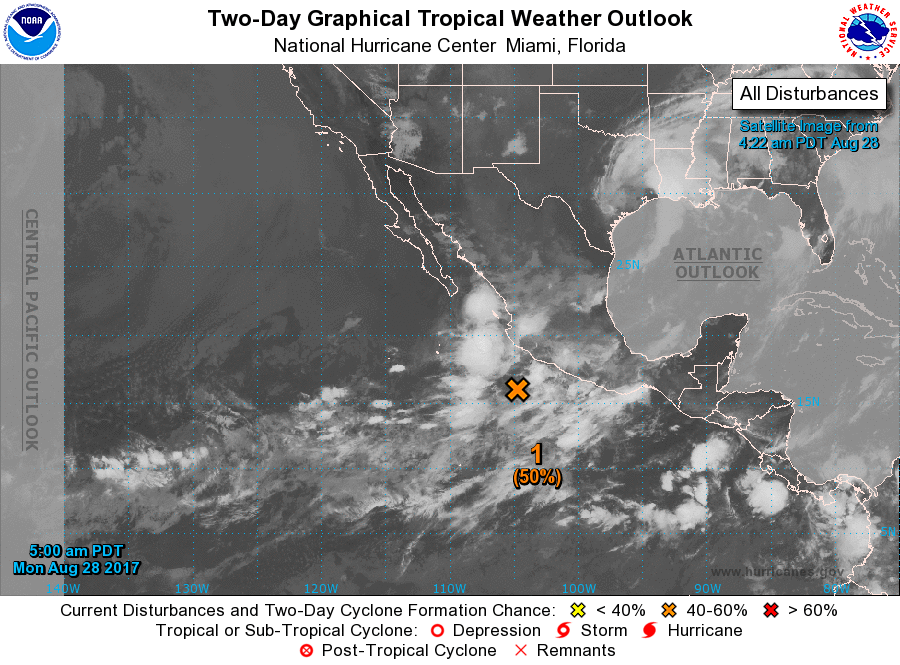
I think attention has to be paid to all indicators, given whats going on..The same storm is now shown by the NHC, on a Northern path with an 80% chance of getting ugly..

Meany - 8-28-2017 at 02:00 AM

Surfs up at the end of the August. The 1st and 2nd of Sept. Go to the store Russ and get supplies.:light:

Russ - 8-28-2017 at 06:15 AM

I'm not sure about the windy site and rely more on eebmike.com.

It will be interesting to compare what happens between the two sites.
I'm stocked up. Thanks Meany
I have been playing on the Windy site and I like the forecast models. You can click on the day and time.


[Edited on 8-28-2017 by Russ]

Hook - 8-28-2017 at 07:12 AM

eebmike is a great consolidator of info, but ultimately the info is from NOAA/NHC. That's the case with most weather sites. So, there is probably not much difference.

If you want to see multiple predictions of ALREADY FORMED STORMS (TD, TS, HURRICANES), you can look at the computer model page on Weather Underground. This page, at times, seems to become inactive once a storm makes landfall. It is listed in this collection of pages. I think the WU grouping is the best source in one place for this. Not as "pretty" as windyty, granted. To access the overall Hurricane and Tropical Cyclone page on WU, go here. It will show all formed storms and invests on a clickable map of the world. Just not much activity right at the moment.

https://www.wunderground.com/hurricane

Here is the main page for TS (formerly hurricane) Harvey, in Texas. Notice the clickable options at the bottom. The computer track page is not valid in this case. But if it were earlier in the life of Harvey, it would have shown about five potential tracks generated by five separate computer programs. There is currently no valid computer track page on any storm, as we are between formed hurricanes, worldwide.

https://www.wunderground.com/hurricane/atlantic/2017/tropica...


[Edited on 8-28-2017 by Hook]

[Edited on 8-28-2017 by Hook]

shari - 8-28-2017 at 07:16 AM

I have found windy site to be quite accurate and use it alot...combined with Buoyweather for local stuff...it usually is accurate for wave height and wind.

I think it will get rather nasty around the tip...it may get sucked over to the warm water and go up the inside or spine so we probably wont even get rain here...but it may go all schizoid and half of it go up the gulf and the other half come up the outside grazing our shores with a big butt swell and wind...I think I will get the plywood ready juuuuust in case. If I was around the tip or Mag Bay area I would definitely be preparing for some weather and if I had travel plans there....I would seriously think about cancelling...unless it is a storm watching trip of course!

shari - 8-28-2017 at 08:03 AM

hmmm....that storm is weird...sure looks like even we may get some rain...maybe I wont bet a pack on no rain! Looks like Mulege may get some as the storm sort of goes from the gulf over the spine to the Pacific...the mid peninsula may get real wet this weekend.

aguachico - 8-28-2017 at 08:07 AM

I use Windy all the time everyday for fishing San Diego/Baja. It is accurate for a few days in advance, but since patterns change, the 3-7 day forecast are just indicators, but are good to know.

elskel - 8-28-2017 at 08:13 AM

Stormsurf model showing the same thing.

chuckie - 8-28-2017 at 08:28 AM

Its not September yet...

shari - 8-28-2017 at 08:50 AM

this will be a warm up..dress rehearsal.
because is it a widespread system it may dump rain over a longer period and area...lets hope it moves fast so not much flooding occurs.

woody with a view - 8-28-2017 at 09:34 AM

We might squeeze in a kamikazee fishing trip on saturday and head home in the afternoon ahead of the storm. Aint afraid of a little rain. Sailflow is showing BdeLA winds pretty light, all things considered.

shari - 8-28-2017 at 10:16 AM

should be ok till Saturday there but hotter than a mother.

chuckie - 8-28-2017 at 10:53 AM

Its now saying that lil sucker will cause life threatening floods and mudslides over Baja, regardless if it forms into a hurricane..Better do your laundry Shari, so Juan has clean britches..

shari - 8-28-2017 at 11:27 AM

that's what I thought when I saw how discombobulated this system looks...lots of rain perhaps...one full day of rain will cause massive flooding in these parts!

BajaMama - 8-28-2017 at 11:43 AM

https://www.windy.com/?20.982,-108.809,4

This is current windy page - nothing like in original link. NHC shows disturbance way t the south.

chuckie - 8-28-2017 at 12:11 PM

And Bob's your Uncle...

AKgringo - 8-28-2017 at 12:57 PM

Quote: Originally posted by BajaMama  
https://www.windy.com/?20.982,-108.809,4

This is current windy page - nothing like in original link. NHC shows disturbance way t the south.


My original post was about the forecast reliability, and it showed the projected path on Thursday. If you advance the date a couple of days, it still looks pretty troublesome!

woody with a view - 8-28-2017 at 01:24 PM

Kamikazee run aborted. Friends aren't up to the task.

StuckSucks - 8-28-2017 at 03:08 PM

Tropical Weather Outlook
NWS National Hurricane Center Miami FL
1100 AM PDT Mon Aug 28 2017

For the eastern North Pacific...east of 140 degrees west longitude:

1. An elongated area of low pressure centered about a couple of
hundred miles south of Manzanillo, Mexico, is producing widespread
disorganized showers and thunderstorms. Environmental conditions
are forecast to be conducive for development, and this system is
expected to become a tropical cyclone within two or three days while
it moves generally northward or northwestward near the coast of
southwestern Mexico and Baja California Sur. Residents in those
areas should monitor the progress of this system, and tropical
storm watches could be required for a portion of the area on
Tuesday. Regardless of development, very heavy rain is expected in
southwestern Mexico and Baja California Sur over the next few days
and could cause life-threatening flash floods and mudslides.
* Formation chance through 48 hours...medium...60 percent.
* Formation chance through 5 days...high...90 percent.

chuckie - 8-28-2017 at 03:10 PM

Yup, thas what it sez...

Bajaboy - 8-28-2017 at 05:18 PM

Quote: Originally posted by woody with a view  
Kamikazee run aborted. Friends aren't up to the task.


It ain't over for me....keep an eye open as she turns out towards the open ocean. My bags are still packed!

[Edited on 8-29-2017 by Bajaboy]

chuckie - 8-28-2017 at 05:50 PM

Good luck with that!...

chuckie - 8-28-2017 at 06:15 PM

Interesting storm in that it seems to be raining and flooding in SDC but no mention of.. that on weather sites...PICS over on TB...And it aint even there yet...do 2 loads Shari...could be a long one

shari - 8-28-2017 at 06:17 PM

OMG....I have never seen such a loopty loo forecast....made me dizzy just looking at it. Safe to say we dont really know what this lolapalooza will do...but I am reconsidering my bet of a 4 pack of guiness draft that we get no rain in Asuncion....tick tick tick


Russ - 8-28-2017 at 06:45 PM

that is the funnest model i've ever seen. keyboard malfunction...

chuckie - 8-28-2017 at 06:53 PM

Yeah, It's hilarious..segue to fish pictures and sunsets...

tiotomasbcs - 8-28-2017 at 07:01 PM

Yeah, it might be funny if you're not sittin in BCS. Newton was a nice little chubasco last year. Let's hope this one passes right on thru. What's her name, by the way? Tio

Meany - 8-28-2017 at 07:39 PM

It looks like it eat a lot of JalapeƱos.;)

MexicoTed - 8-28-2017 at 11:17 PM

Saw a video of flooding on Gringo Gazette instagram account. I could only link to it.


https://www.instagram.com/p/BYWiE3pFeJn/

basautter - 8-29-2017 at 05:06 AM

Send rain to Tucson please!

LaTijereta - 8-29-2017 at 06:33 AM

Looks like rain later this week..


IMG_0850.PNG - 11kB

shari - 8-29-2017 at 06:57 AM

Quote: Originally posted by tiotomasbcs  
What's her name, by the way? Tio


Hola Tio...is it raining yet in your barrio? Get ready for some flooding amigo from Lidia! you know the drill...stock up on water, beverages, gas etc....should be some epic surf on the tip in the next few days.

Here are the names of storms this season here.

Beatriz Jova Selma
Calvin Kenneth Todd
Dora Lidia Veronica
Eugune Max Wiey
Fernanda Norma Xina
Greg Otis York
Hilary Pilar Zelda

vandenberg - 8-29-2017 at 07:24 AM

It's sure funny that weather underground doesn't even mentions this disturbance

woody with a view - 8-29-2017 at 08:18 AM

Quote: Originally posted by Bajaboy  
Quote: Originally posted by woody with a view  
Kamikazee run aborted. Friends aren't up to the task.


It ain't over for me....keep an eye open as she turns out towards the open ocean. My bags are still packed!

[Edited on 8-29-2017 by Bajaboy]


Zac, with all the rain the water will be chocolate. Bad luck this time.

rogbag - 8-29-2017 at 10:26 AM

We could use a little moisture here in town. Been real dry so far this year. I could do without the wind tho....

wetto - 8-29-2017 at 12:03 PM

I have been thinning out and placing things in higher ground storage for the past month or two. on the final push today to store last of the furniture. Waiting for more info before the stove, water heater and refrigerator get moved.
When / if it starts to form into a cyclone I'll do a final pack..
Riverside living in Mulege means always to expect the unexpected. Keeps us on our toes and something to do in the summer doldrums!

shari - 8-29-2017 at 12:34 PM

hopefully many people are preparing for flooding....getting stores in like water, gas, beer, food etc as roads will be flooded so no delivery trucks get in...it WILL rain amigos!!!

Bob and Susan - 8-29-2017 at 12:57 PM

here is the latest SAT picture...

where is this storm?


829storm.jpg - 167kB

bajabuddha - 8-29-2017 at 01:28 PM

https://s19.postimg.org/jo4lfsvb7/two_pac_2d0.png

http://www.eebmike.com/


[Edited on 8-29-2017 by bajabuddha]

Bob and Susan - 8-29-2017 at 01:44 PM

they predict rain for mulege Saturday and sunday....

no one shows a path for a storm

that section looks very unorganized

spinners usually form quickly

chuckie - 8-29-2017 at 01:55 PM

NHC and EEBM now showing TWO storms, back to back, closest one to SOC and Mulege is 100% predicting flooding torrential rains..Next one 80% about a day behind...

Bob and Susan - 8-29-2017 at 02:33 PM

chuckie could be correct

satstorm.jpg - 86kB

chuckie - 8-29-2017 at 02:39 PM

Chuckie IS correct...

woody with a view - 8-29-2017 at 02:47 PM

Looky at Windy site for saturday. Get your ducks in a row.

tiotomasbcs - 8-29-2017 at 04:38 PM

Sittin on high ground out here at the beach in Pescadero. Arroyo Grande may flood as in 2002 Julietta closed the hwy. For us, Two miles back to Hwy 19 passes a few flows or rioletas and mud bogs. Biggest problem is up on hwy if/need to go anywhere?! We're ready for two days/ week or more. Odile has schooled most in our area! If we lose power I hope it's not for long. Most have genies! The locals are the ones that suffer but have been thru many storms before. Thinkin positive. Tio

bajabuddha - 8-29-2017 at 04:46 PM

Wanna relocate to Houston? At least there ain't no Baja Gators... do chupacabras swim? :?:

Alm - 8-29-2017 at 05:23 PM

Eebmike has been reliable so far. They all use the same source. For Saturday I would not look at Windy, or any other site - until at least Wed-Thu.

Alm - 8-29-2017 at 05:32 PM

Quote: Originally posted by tiotomasbcs  
We're ready for two days/ week or more. Odile has schooled most in our area! If we lose power I hope it's not for long. Most have genies!

"All" must have solar, in addition to genie. Works under heavy clouds too, just not as good. Enough to run a small fridge and lights.

I'm curious - what "ready" means and how it would help, other than packing couple of boxes of supplies to run away, leaving everything behind. That is, - if road conditions will let you go. After the Odille many people were stranded, and being stranded on the road can be worse than at home.

Bob and Susan - 8-29-2017 at 05:43 PM

don't drive in the rain...the vados flood FAST

all the big semis sit at the gas station
smart

just hunker down

the wind is the bad thing out here on the bay.
those shells HURT!!!

Bajaboy - 8-29-2017 at 06:22 PM

Quote: Originally posted by woody with a view  
Looky at Windy site for saturday. Get your ducks in a row.


This site looks cool but not sure if it's a proven commodity. I'm relying on my tried and true along with seasoned veterans on the ground.

willardguy - 8-29-2017 at 06:57 PM

Quote: Originally posted by Bajaboy  
Quote: Originally posted by woody with a view  
Looky at Windy site for saturday. Get your ducks in a row.


This site looks cool but not sure if it's a proven commodity. I'm relying on my tried and true along with seasoned veterans on the ground.


the weather stone?

vandenberg - 8-29-2017 at 07:56 PM

Well weather underground and Windy agree on the amount of rain we may expect here in Loreto/Mulege region.

Alm - 8-29-2017 at 11:06 PM

Quote: Originally posted by vandenberg  
Well weather underground and Windy agree on the amount of rain we may expect here in Loreto/Mulege region.

Windy predicts no rain until Thursday morning. Then - moderate 3mm rain until Friday. Then it gets a lot worse on Saturday, but this is 4 days out, so the accuracy is,.... accordingly.

woody with a view - 8-30-2017 at 04:03 AM

Define accurrate? Somethings coming soon. Beware!

IMG_0077.PNG - 147kB

BajaMama - 8-30-2017 at 05:43 AM

http://www.nhc.noaa.gov/?epac

Looks like 100% chance of formation and due south of Cabo. Pray for western movement!

shari - 8-30-2017 at 07:19 AM

Hmmm...this storm is a real trickster capable of anything...this is from this mornings forecast....

"It should be noted that since there is
considerable spread in the model guidance, this official track
forecast has greater-than-usual uncertainty."

What we do know is there will be alot of rain and flooding everywhere in Baja Sur....although it is possible we still get none...because what happens is although the models say it will go west....it gets sucked over to the gulf by the warmer water leaving our little heel of land out of the rain....still not ready to bet we get none but it wouldnt surprise me.....we are preparing anyway.

I am going to start a new storm thread so we can begin to get onsite reports. I heard there was rain yesterday down south so the ground will already be wet which is bad as the ground wont absorb water and it will runoff wildly....remember NEVER CROSS A ROAD WITH WATER RUNNING OVER IT!

Alm - 8-30-2017 at 02:28 PM

THIS is a storm thread already, Shari :)

Accuracy... Some are concerned more about wind, I'm worried more about flood. Numbers are important. 3mm/day of rain is nothing, 30 mm may cause flood (and will, if it lasts for more than a day). So far it looks like it will turn to the West on Saturday at BOLA-Asuncion line. Asuncion will get more wind, BOLA - heavy rain up to 20mm, and then it will end.
Can still change.

mtnpop - 8-30-2017 at 06:01 PM

Quote: Originally posted by wetto  
I have been thinning out and placing things in higher ground storage for the past month or two. on the final push today to store last of the furniture. Waiting for more info before the stove, water heater and refrigerator get moved.
When / if it starts to form into a cyclone I'll do a final pack..
Riverside living in Mulege means always to expect the unexpected. Keeps us on our toes and something to do in the summer doldrums!


wetto: please check your u2u thanks

Udo - 8-31-2017 at 08:01 AM

Mil gracias for your input, Shary (:bounce:)

Your expertise is really appreciated. Please let me know if I should board up the front windows.

shari - 8-31-2017 at 08:31 AM

I anticipate the storm to go up the spine and lose power by the time it gets up here although we are getting the plywood ready to board up just in case(plus it helps with keeping the driving rain from coming in the windows). I was in a storm like this in GN and lots of damage from wind and flooding...very unusual.
Important to get stores of water & food in as delivery trucks wont be coming in for awhile...Lidia is coming in fast & hot!

Alm - 8-31-2017 at 11:47 AM

Well, the path didn't move to the West. It will follow the peninsula until at least BOLA, and then will turn West on Saturday evening. Expected amount of rain at the end of the path remains the same - under 20mm in BOLA and much less in BA. BOLA will get soaked, BA will get pummeled with wind, not much rain.