BajaNomad

Libramiento Ensenada opening date?

John Harper - 9-19-2017 at 08:03 AM

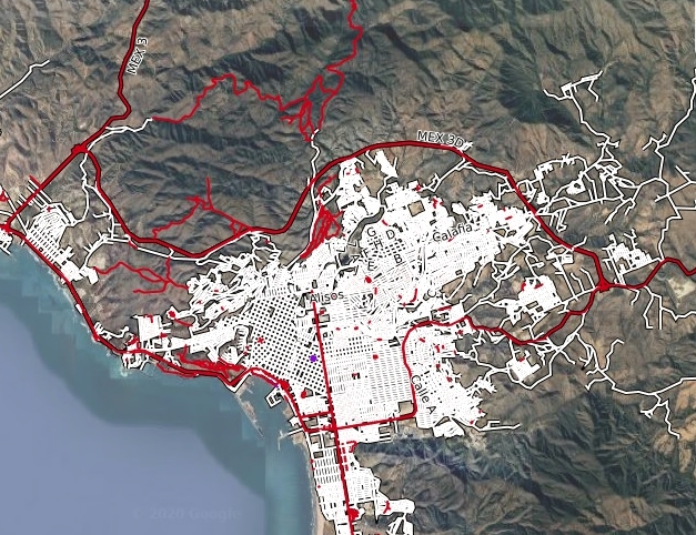
I just noticed a new highway bypass around Ensenada, connecting 3 from Tecate to 3 toward San Felipe near Ojos Negros. When is the proposed opening date of this road? Just planning my next adventure driving through Ensenada.

Or, is this just a failed project?

John


[Edited on 9-19-2017 by John Harper]

David K - 9-19-2017 at 09:56 AM

The dream plan is it will continue on from the Hwy. 3 crossing to the Maneadero area so you can go around Ensenada, as at other Mexican cities.
It is not even open to Hwy. 3 (San Felipe hwy.) but some might use the portion made so far to get to northeast Ensenada neighborhoods.

John Harper - 9-19-2017 at 03:07 PM

Yes, I looked at the satellite view, still looks "under construction" with a way to go to Hwy 3.

John

David K - 9-19-2017 at 03:49 PM

Someone here (bajaguy, maybe?) posted the map of its planned route here some time ago.

chumlee57 - 9-19-2017 at 08:28 PM

when that gets done it will be awesome, I personally enjoy a stay for the evening in Ensenada, it's a cool little walk around town, my wife loves the shops, etc., I love the food. But that whole stretch from Ensenada to San Quetin is sometimes a little long in the tooth, especially on the return side of a trip south. Not sure the new 'proposed' road will get completed any time soon, but it will be a nice alturnative if it does get done

bajaguy - 9-19-2017 at 08:48 PM

Here is my take on the bypass road (Libramiento) from first hand observations

They have been working on this for 4+ years. It was originally envisioned to be a bypass around Ensenada for commercial truck traffic to keep them off of city streets.

Originaly 4 lanes, then narrowed down to two lanes (for a truck bypass???)

The construction has been plagued by landslides (improper sidewall cuts) and washouts (improper drainage). What has been paved (about 4 miles or less) is already potholed.

The road is not officially opened yet and and there have been several accidents due to inattentive driving

Apparently they are now working on a 4 lane bridge spanning a rather large gully, and they hope to connect with Hwy 3 headed to Ojos Negros "soon"

At the pace they are going and repairing what they have already built we will never live long enough to see it completed to join Hwy 1 south of Manedearo

I personally would not drive on it as it is an accident waiting to happen. I feel safer driving through downtown Ensenada

This project is in the same league as the Tecate to El Sauzal (Ensenada) railroad and the "new" Ensenada airport

rts551 - 9-20-2017 at 08:18 AM

Road construction has been going on for many years. One picture I can find of the sign for construction is from Nov 2008.

John Harper - 9-20-2017 at 09:03 AM

I kind of had a feeling is was one of those type projects. I'll just plot a better route through Ensenada to get to 3 next time. Not go blindly with my friend's dim recollection of a short cut.

John

David K - 9-20-2017 at 11:19 AM

Quote: Originally posted by John Harper  
I kind of had a feeling is was one of those type projects. I'll just plot a better route through Ensenada to get to 3 next time. Not go blindly with my friend's dim recollection of a short cut.

John


Take the coast route into town (Tourist Zone), right fork... and go all the way to the 'new' route across to the mountains, signed for San Felipe. It goes under Highway 1 without any direct connections, sadly, if you are northbound on 1. When you come back into Ensenada from Ojos Negros, you are automatically routed on this new east/west street to the harbor/ tourist street. Need a map?

StuckSucks - 9-20-2017 at 11:22 AM

I think it's supposed to open at the same time as the Highway 5 project and the San Felipe bi-pass road.

bajaguy - 9-20-2017 at 01:40 PM

Actually, if you take the left fork by the Hotel Coral Marina and the colleges at the Soriana shopping complex (Not the tourist/Costero route to the right) you will be on 10th street. When you get to the stoplight intersection with the Auto Zone, PEMEX and Calimax, go one block to your right and that will be 9th. Take a left onto 9th to Reforma, make a right on Reforma and go about 4 blocks south to the statue in the center of the road. That stoplight intersection will be Cortez. Make a left on Cortez and follow it to Hwy 3 headed to Ojos Negros and San Felipe. Easiest and quickest way to Hwy 3


Quote: Originally posted by David K  
Quote: Originally posted by John Harper  
I kind of had a feeling is was one of those type projects. I'll just plot a better route through Ensenada to get to 3 next time. Not go blindly with my friend's dim recollection of a short cut.

John


Take the coast route into town (Tourist Zone), right fork... and go all the way to the 'new' route across to the mountains, signed for San Felipe. It goes under Highway 1 without any direct connections, sadly, if you are northbound on 1. When you come back into Ensenada from Ojos Negros, you are automatically routed on this new east/west street to the harbor/ tourist street. Need a map?

David K - 9-20-2017 at 02:51 PM

Those directions make my head swim Terry!

Let me try this to show what route I was speaking of...


It is even shown as Hwy. 3 route across town on Google maps. I added arrows and a red circle where it goes under Hwy. 1.

rts551 - 9-20-2017 at 02:57 PM

Looks like the long way around. why not use calle 11 or any other number of streets across.

I use Cortez.


[Edited on 9-20-2017 by rts551]

bajaguy - 9-20-2017 at 03:08 PM

10th doesn't go to Reforma from Hwy 1, you still have to get on 9th (the truck route) or 11th to get to Reforma, then south to Cortez

(
Quote: Originally posted by rts551  
Looks like the long way around. why not use calle 11 or any other number of streets across.

I use Cortez.


[Edited on 9-20-2017 by rts551]

David K - 9-20-2017 at 03:08 PM

Long way distance, but maybe shorter in time?
Because of most of us hating city driving... and the Hwy. 3 route shown on the map is less crowded, four lanes wide, and not a ton of cross-traffic. But, please, show us your route... as I recall, Cortez is the original road out of town, going uphill, and has a zillion stops.

bajaguy - 9-20-2017 at 03:10 PM

That is the long way David, right through the middle of town and the tourist district, plus you have to backtrack


Quote: Originally posted by David K  
Those directions make my head swim Terry!

Let me try this to show what route I was speaking of...


It is even shown as Hwy. 3 route across town on Google maps. I added arrows and a red circle where it goes under Hwy. 1.

bajaguy - 9-20-2017 at 03:21 PM

Since I don't know how to do the fancy maps..........

At the upper left corner of your Map, there is a street named ...de la Paz (actually Bahia de la Paz) that comes off of Hwy 1 to the west. Bahia de la Paz turns into Calle Diez (10th Street). Drop down one street to Calle Novena (9th street)

Follow 9th to Reforma, turn right (south) on reforma to Cortez, left on Cortez to Hwy 3, left on 3 to Ojos Ngros and San Felipe

Quote: Originally posted by David K  
Those directions make my head swim Terry!

Let me try this to show what route I was speaking of...


It is even shown as Hwy. 3 route across town on Google maps. I added arrows and a red circle where it goes under Hwy. 1.

John Harper - 9-20-2017 at 04:28 PM

I was looking at taking Ave. Bahia de La Paz to Calle Novena, to right on
Ave. Reforma, then left on Calz de Aguila to hit Hwy 3. The google street view shows Novena open from BDLP all the way to Reforma.

I just remember seeing Aguila a couple times last year on our lost journey, and just had a feeling. I just like the name Aguila too.

Thanks, that's exactly, or close to the route I was planning. Cortez works for me too.

John


[Edited on 9-20-2017 by John Harper]

bajaguy - 9-20-2017 at 04:50 PM

Exactly


Quote: Originally posted by John Harper  
I was looking at taking Ave. Bahia de La Paz to Calle Novena, to right on
Ave. Reforma, then left on Calz de Aguila to hit Hwy 3. The google street view shows Novena open from BDLP all the way to Reforma.

I just remember seeing Aguila a couple times last year on our lost journey, and just had a feeling. I just like the name Aguila too.

Thanks, that's exactly, or close to the route I was planning. Cortez works for me too.

John


[Edited on 9-20-2017 by John Harper]

BajaDave - 4-10-2018 at 11:48 PM

Has there been any progress in the nearly 7 months since the original post was made about this?

[Edited on 4-11-2018 by BajaDave]

bajaguy - 4-11-2018 at 02:05 AM

Nope

Quote: Originally posted by BajaDave  
Has there been any progress in the nearly 7 months since the original post was made about this?

[Edited on 4-11-2018 by BajaDave]

thebajarunner - 5-21-2020 at 03:44 PM

I just posted on this topic on the following thread:

http://forums.bajanomad.com/viewthread.php?tid=94486

David K - 5-21-2020 at 04:16 PM

Yes, and that is exactly why I bumped this post up... there are others. Bajaguy seemed to have the latest... but over two years later and nothing new?

Can you get to the Ojos Negros/ San Felipe highway on it without city streets to negotiate, like a real libramiento?

esemjay1956 - 5-22-2020 at 07:27 AM

awesome responses to my bypass question....I have been reading BN for 15 years and never posted until now. And nothing political!
A Mexican miracle!

David K - 5-22-2020 at 09:38 AM

Welcome to posting on Nomad!
You can look at Google Earth, Bing, or CalTopo to see satellite images of the road... of course they may be years old.

On CalTopo, hybrid map... It shows the road as Mexico 3-D and completed between the two Mexico #3 highways (to Tecate and to San Felipe)...


Pacifico - 5-22-2020 at 10:00 AM

I met a Mexican friend of mine in Tecate the other day to give him some parts and he used the new road. He lives by where the road hits Hwy 3 on the southern end. He said it was open and saved him about 45 minutes by not having to go through town!

He did say it is not totally finished, but was open and usable...

[Edited on 5-22-2020 by Pacifico]

David K - 5-22-2020 at 10:53 AM

Awesome! Thanks Pacifico!