BajaNomad

Turkeys on the beach!

canoe4me - 12-16-2017 at 09:53 PM

This is a mildly delayed trip report from Thanksgiving 2017. Its also my first trip report. We spent a week in Baja looking for tacos and solitude and secluded spot to cook a turkey. We found it!! We drove to Cabo last year for christmas but spent so much time in the truck that we needed to go back for more time outside. We camped every night out in the desert with a roof top tent and ground tent.

We (family of 5 with three kids 12, 9, 7) crossed in Mexicali took 5 to San Felipe. Mexicali welcomed us to Mexico with the ominous smell of raw sewage. Fortunately it was not an omen. We stopped for dinner on the malecon in San Felipe as the sun set. We picked a taco joint at random before breaking all the rules and driving south in the dark to Bahia Gonzaga. We did not let the little guy in the background of the restaurant picture take the wheel!

We camped out in the desert on a dirt track to the west of the highway south of Alfonsina's and were wondering in the dark why the dirt track was so torn up in some sections. In the morning we realized that we had driven across the Baja1000 course.

I'll try to post one day (or segment) at a time in what seems to be normal for this site.


mex0.jpg - 28kB mex2.jpg - 27kB mex1.jpg - 21kB mex3.jpg - 21kB

woody with a view - 12-17-2017 at 06:15 AM

Put them alll in one thread. Just keep adding to it because they get lost in the shuffle otherwise. Or not.

advrider - 12-17-2017 at 08:57 AM

Keep it coming, love trip reports....

ehall - 12-17-2017 at 10:00 AM

Need some more! How did you end up cooking the turkeys? In the pic in San Felipe it looks like the wind was blowing pretty good.

canoe4me - 12-17-2017 at 10:59 AM

Day 3

We continued south on 5 through the construction to Coco's corner. I must be kinda dense but I don't really get why this place is so special. Perhaps traveling with a family and having to explain another mans fascination with giant (and tiny) underpants to your 12 year old son is a little awkward.

I had planed on finding some solitude south of BOLA near Punta Ballena but a late night Google Earth mission showed some interesting beaches to the north of BOLA. I was able to follow a track back to the BOLA road via the Playa Amarga. I have been using the NatGeo Baja maps which show no road in that area but we decided to at least try to follow the road. Some searching of the internet and this site showed a little info about a beach called Ensenada Alcatraz. This would be our primary goal and if the road was impassable we would try the Punta Ballena area.

We fueled up in BOLA and backtracked to the playa Amarga. The dry lake bed turned out to be amazing for Onewheel riding. The Onewheel is an electric skateboard with a single go cart wheel. The road then climbs a pass that is very reasonable and drops into a wash. There was VERY deep sand and I deflated my tires to 18 psi and had a few worried moments but no real problems. I used the wonky Toyota Crawl control sand mode and I guess that helped?

After a few miles of sandy wash you get out onto a coastal flat with a few sandy wash crossings but no other major problems. I was worried about tidal mud flats but there were none of any consequence.

We were able to drive right up to a huge white beach which did have rocks at low tide. We then camped there for the next 3 nights.

mex8.jpg - 20kB mex5.jpg - 19kB mex9.jpg - 21kB mex10.jpg - 22kB

woody with a view - 12-17-2017 at 11:31 AM

Looks most excellent so far!

BornFisher - 12-17-2017 at 12:27 PM

Looks like you found a great place, with the cleanest bathroom in Baja. Just hope they were marked ladies and gentlemen!!

TMW - 12-17-2017 at 02:29 PM

["There was VERY deep sand and I deflated my tires to 18 psi and had a few worried moments but no real problems. I used the wonky Toyota Crawl control sand mode and I guess that helped?"]

I'm not sure David K knows about that Toyota control system. But if it works for you great.

Love the pictures and report so far.

I think you were at the beach at Bahia Guadalupe. If so there is a shine at the south end near the beach at the fish camp against the hill.


David K - 12-17-2017 at 02:37 PM

Crawl Control is a cruise for low range and works with MultiTerrainSelect which is basically adjustable A-TRAC so it is a good thing!
Where is Day 2, or is that when the report begins?
Keep it coming canoe4me!


[Edited on 12-17-2017 by David K]

woody with a view - 12-17-2017 at 05:05 PM

Party pooper

canoe4me - 12-17-2017 at 07:57 PM

Day 4/5
I'll break this up into hikes/beach time and the Thanksgiving fest. This post is not about thanksgiving.

(OK so day 1 was mostly the w-word that has no business on this forum followed by many hours of driving in the dark from Carson City to Ridgecrest. I'm bored typing that part and am only including it per special request.)

As I mentioned we are from Carson City and our typical beach is at Lake Tahoe. None of us know much about the ocean. We took a paddle board and even though the water was much warmer than Tahoe the ocean floor beyond about 3 feet deep was covered with dinner plate sized bat rays? Sting rays? We were not taking many chances. The kids are typically crazy about swimming and while they did ride the paddle board in the morning until the wind came up, we largely stayed out of the water. We did find a carcass of a hammerhead shark that was bout 3' long and that also discouraged the kids from getting too wet. We do know about the shuffle etc. but beach combing and hiking seemed more popular with the kids.

This beach does not see too much traffic so we were all able to find sand dollars and the kids all made shell collections.

We hiked up to the fisherman's shrine on the hill at the east end of the beach and to some dunes in the valley east of that. To the west of the beach we climbed a hill to get a view and found some type of Native medicine wheel. There was a circle of rocks 10 meters in diameter made of rocks. There was a somewhat isosceles triangle of rocks about 3 meters per side in the center with three smaller circles at the tips of the triangle that blended with the outer circle. Some of the rocks were larger than 1 person could comfortably move. I tried to google native rock circles and medine wheels of Baja but could not find anything that looked like what I found. Near that area there were many old shells at the top of the hill. We did not have too much time to fully explore the hilltop because dinner was in the oven.

I tried standing in the center of the triangle with my arms up and in various other position and even tried to get into a lotus position but I did not feel any extra cosmic energy. I'm probably just not a true believer.

We saw a few fishing boats but otherwise we had the place to ourselves.
We did see and hear coyotes at night.

My wife might hangout on a beach in a lounger for the rest of her life but I have vacation ADD and with so much Baja to see we could not stay too long. I'll post about cooking the turkey on the beach next.


beach2.jpg - 16kB beach1.jpg - 44kB beach3.jpg - 15kB beach4.jpg - 16kB beach5.jpg - 17kB Beach6.jpg - 23kB beach7.jpg - 23kB beach8.jpg - 32kB

advrider - 12-17-2017 at 09:17 PM

I will be in BOLA for a few days in March on my moto and would like to check this out. Would this be north on the road past La Gringa? I'm thinking its the same way as the window rock trail that I hope to ride?

canoe4me - 12-17-2017 at 09:28 PM

Quote: Originally posted by advrider  
I will be in BOLA for a few days in March on my moto and would like to check this out. Would this be north on the road past La Gringa? I'm thinking its the same way as the window rock trail that I hope to ride?


Adv,

We did not take the road north of La Gringa. We turned north off the highway about 30k west of BOLA. The road we took crosses a dry lake then climbs over a pass before descending to Bahia Guadalupe area. I have read that a road north of La Gringa does or perhaps did exist. It went to an old mine and then perhaps down to our beach. I have seen some maps that show the southern portion of Bahia Guadalupe labeled as La Gringa but most modern maps show La Gringa as immediately north of BOLA.
I don’t know anything about the window rock trail.

advrider - 12-17-2017 at 09:43 PM

Got it! Just the info I was looking for, I think I know how to get there, thinking I can is half of the fun and makes for an adventure. Keep up the good report and good on you for giving your kids memories of a life time. ....

[Edited on 12-18-2017 by advrider]

BajaBlanca - 12-17-2017 at 11:40 PM

Great report. I too was not impressed with Coco's corner decoration. BUT Coco himself is a legend - so loved by many.

Beautiful photos. If we didn't already live here, they would make me want to move here quickly.

canoe4me - 12-18-2017 at 09:55 PM

Day 5 Cooking the Feast!! My family wanted a traditional thanksgiving this year so we traveled to a foreign country and made a feast in the wilderness.


I'm not a chef and have no business in a real kitchen so I have to cook outdoors. I fervently believe that food tastes better when you are camping so a little extra effort making meals pays off big!!

I have cooked a pig in a pit while I lived in Kentucky but never a turkey. Pit cooked meat is really good and really easy. Any neanderthal could do it.

The first part is the hardest. Dig a pit much bigger than your meat. There were only 5 of us so we only cooked a 1/2 turkey that we bought pre-marinated from the local grocery store back home. We smuggled the turkey into Mexico in a cooler. It started frozen and was thawing nicely by day 5. I dug the pit and lined it with stones. I did not get stones from the beach but rather dry stones from the desert. Apparently if the stones are water saturated they can explode like pop-corn. The stones hold the heat and release as the coals cool. We made a trip in the truck to load up with wood where a wash met the beach. We stuck with the really heavy dense wood that we found. Ironwood? Wood in Baja seems either really dense or really light. We picked the heavy stuff and it made fabulous coals. I broke it up with rocks like any true caveman. (my wife thinks I might be first generation to walk upright.)

If you have a lot of meat you need more wood and time in the oven. I cooked the pig overnight but I figured 7-8 hours would be fine for the small turkey. (somewhere on the internet is a formula for pound per hour) I got up early on thanksgiving and made the fire and let it burn down to coals. I then shoveled half of the coals out of the pit, shoveled in a layer of sand. The turkey was sealed in two oven bags followed by several layers of heavy duty foil and finally I wrapped up the package with wire with a long tail. The tail helps pull the turkey out of the dirt. The turkey then gets covered with more sand and then the rest of the coals. Then all of the coals get buried with more sand.

Now it's time for a hike! After the turkey had cooked for 6 hours we started making the rest of the meal. Scratch made dressing/stuffing, smashed potatoes, gravy, creamed green beans and rolls round out the meal. I then dug up the turkey and it was perfect! I highly suggest real shoes when digging up hot coals. No carving the pit cooked turkey. The meat was moist and fell apart like pulled pork!

We planned to eat on the beach at sunset. The wind was stronger than previous days but otherwise the meal was perfect. Pilgrim hats courtesy of my fourth grade daughter.


a9.jpg - 21kB a2.jpg - 24kB a4.jpg - 29kB a5.jpg - 20kB a6.jpg - 29kB a7.jpg - 19kB a8.jpg - 26kB

woody with a view - 12-19-2017 at 03:33 AM

That’s livin!

ehall - 12-19-2017 at 04:01 AM

Awesome. Great looking meal.

David K - 12-19-2017 at 07:24 AM

Thank you for the continued adventure family story!
Perfect Baja camping experience.

Food for personal consumption is not illegal to bring into Mexico, so no laws were broken. Only when there was Mad Cow hysteria was beef forbidden.

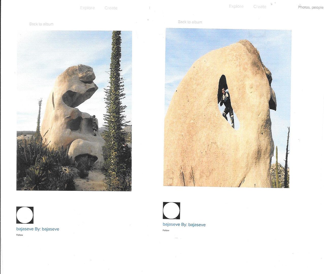
I almost will guess the rock formation was made by New Age (Hippy) campers many years ago?

The road to the La Gringa area and the El Toro copper mine do not cross the mountains to Bahía Guadalupe/Ensenada Alcatraz.
Taking the Agua Amarga dry lake road (Km. 38) is the way. They are included on my maps I am making this month, posted here:http://forums.bajanomad.com/viewthread.php?tid=88227

Thanks for the trip report... Well Done!

nbentley1 - 12-19-2017 at 09:38 AM

We did the same this year for Thanksgiving on Playa Enscondida. Came out perfect as well.

carlosg - 12-19-2017 at 10:58 AM

Thanks Keith for your family's trip and "cooking in the sand" report... you guys obviously had a great time and found solitude in Baja... nice end inviting photos.... Our plans had a turn so we had to do some changes to our Thanksgiving plan... we'll see you in Baja next time... Our plan for next Spring Break is to do a loop of that area if we can do it on a 2WD...

TMW - 12-19-2017 at 01:12 PM

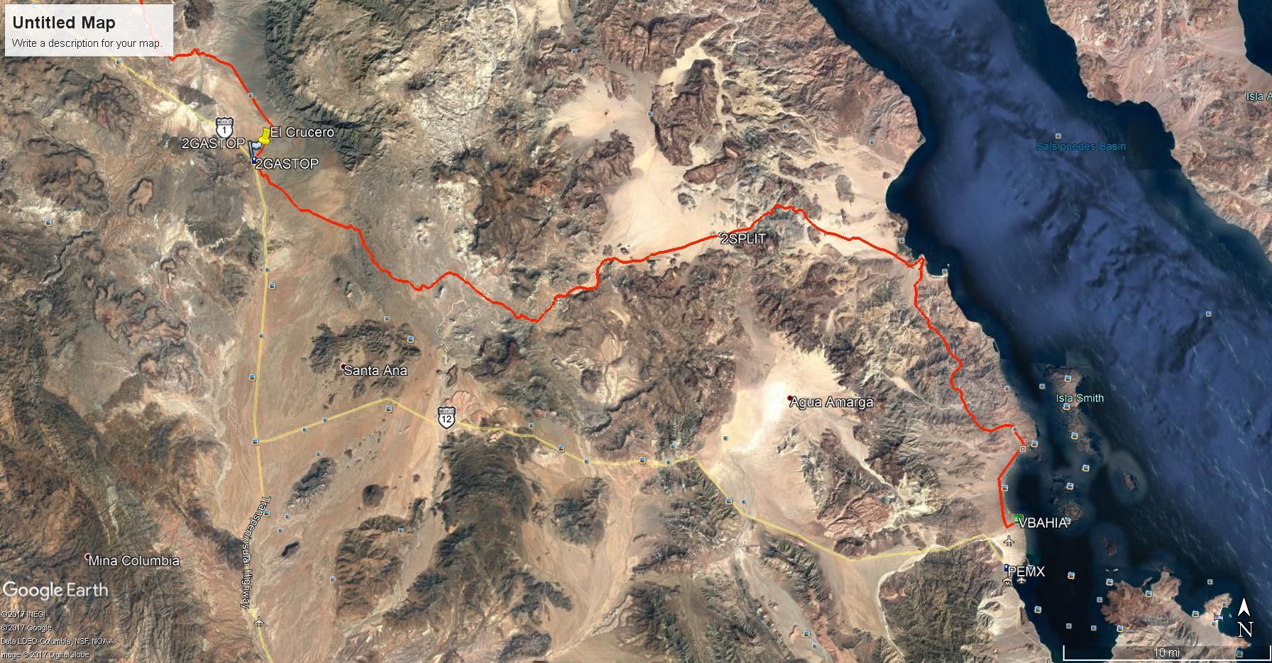
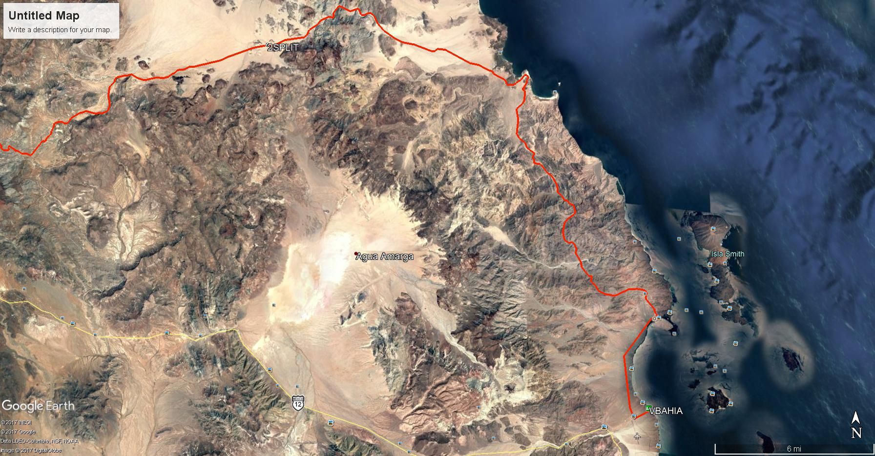
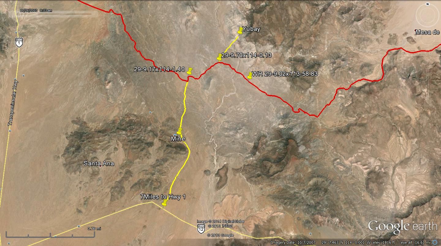
The Window Rock trail goes north out of LA Bay toward Bahia Guadalupe then west going near Yubay. The trail is mostly single track.

WR Trail from El Crucero to LA Bay


Closer to LA Bay


Near Yubay


Window Rock Pictures from Bajaseve


[Edited on 12-19-2017 by TMW]

David K - 12-19-2017 at 01:58 PM

Good post TW!
Looks like it goes from the copper mine north-west from La Gringa. That must be a crazy m/c ride as the is a mountain all around there and no 4x4 road goes beyond.
Did Bill Nichols create it? WOW!!!

TMW - 12-19-2017 at 02:17 PM

Yes Bill Nichols first did it. When I zoom in on GE it follows mostly arroyos from LA Bay. Bajaseve did it a couple of years ago with a group and sent me the file.


canoe4me - 12-19-2017 at 06:33 PM

Day6/7 Onward!

After awaking from our turkey coma we cleaned up and moved on. We spent some time exploring the Bahia Guadalupe environs before driving back to BOLA to stock up on cokes and snacks. The kids are developing a taste for spicy Mexican potato chips and I can’t blame them.

We went south towards San Borja with a side trip to Montevideo to see the paintings. I was surprised to see a large mule deer there that was a little darker in coloration but otherwise very similar to the deer that raid our flowerbeds back home.

We took so much time wandering the cliff line that the sun was nearly down by the time we returned to our truck. We did not make San Borja before we got too tired and spent a glorious star filled night among the boojum trees and cactus.

We arrived at San Borja early the next morning and had a great tour of the mission and grounds. The guide told us that he rarely sees gringo niños there. He confirmed what all of our friends said about us being crazy for driving our kids to Mexico. I’ll take crazy if it means days on deserted beaches and touring lonely relics.

We descended back to route 1 way ahead of schedule for the first time on this trip. Heading north we took the turn off to Santa Rosalia to look for more tacos. We didn’t find tacos but did find some fun on the beach west of town. There were many blue jellyfish washed up on the beach and in the waves. My kids decided they will take swimming in Tahoe’s cold waters over the monster infested warmer ocean any day. We need to make some friends that can teach us about the ocean.

Desperate at that point we drove back to Bahia Gonzaga and got our Taco fix at Alfonsinas. The place was nice but a little too country club for us. We enjoyed the views and tacos before disappearing out into the desert for the night.


ab1.jpg - 33kB ab2.jpg - 32kB ab3.jpg - 18kB ab4.jpg - 22kB ab5.jpg - 23kB ab6.jpg - 23kB ab7.jpg - 20kB

ab8.jpg - 12kB

advrider - 12-19-2017 at 07:11 PM

Quote: Originally posted by TMW  
Yes Bill Nichols first did it. When I zoom in on GE it follows mostly arroyos from LA Bay. Bajaseve did it a couple of years ago with a group and sent me the file.


Thanks for the info, any chance you would share the tracks? The ones I have I think cut across the dry lake bed and miss radiator pass trail? Not sure if the split is obvious or easy to miss? We are ridding that area in late March. Thanks

David K - 12-19-2017 at 07:15 PM

Santa Rosalillita, maybe?
North of Nuevo Rosarito, where the San Borja (west) road meets Hwy. 1... and then a wide paved road to the coast, at the failed marina project 'Escalera Nautica' from a dozen years ago.
Montevideo is a grand place and the boojums are huge near there!
Thank you and keep it coming, please!

canoe4me - 12-19-2017 at 07:38 PM

Quote: Originally posted by David K  
Santa Rosalillita, maybe?
North of Nuevo Rosarito, where the San Borja (west) road meets Hwy. 1... and then a wide paved road to the coast, at the failed marina project 'Escalera Nautica' from a dozen years ago.
Montevideo is a grand place and the boojums are huge near there!
Thank you and keep it coming, please!


David, Santa Rosalillita is the place. Google maps lists it as Santa Rosalita but it was the longer name on the paper map.

David K - 12-19-2017 at 08:28 PM

Yep, one of the places where there is more than one spelling. It was Santa Rosalía originally, but after the French used that name for their copper mine town, to avoid confusion the little Pacific bay changed to "Little Santa Rosalia" which is Rosalillita and alternately spelled (incorrectly) as Rosaliita.

canoe4me - 12-19-2017 at 08:54 PM

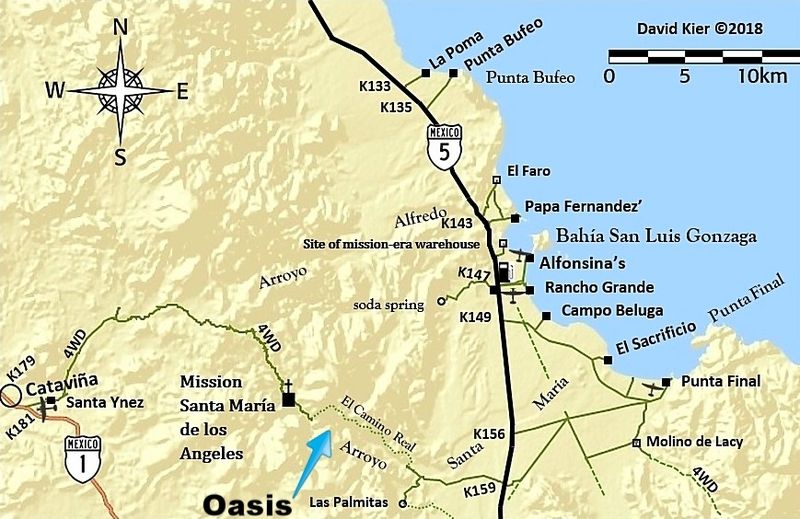
Day 8 Oasis Catavina

Feeling more than a little stiffed by our fears of the ocean we looked for alternative swimming holes. Prior google earth searches showed an interesting spot west of Gonzaga bay.

We camped at the end of the road in a wash and the next morning followed the tracks west up a beautiful winding granite wash with more palm trees and more evidence of water with each bend.

The hike was brutal, the first half was deep sand and the second half was over, under, and around huge boulders. I figure it was about 5 miles each way.

The swimming hole at the end was worth every step! Paradise! Other than a few bugs and frogs there seemed to be nothing that might eat or sting us in that water!! Our kind of place! We swam for an hour with lots of cliff jumping before it was time to head back.

We again drove in the dark back to San Felipe. I guess that if there is a road to drive in the dark, it's that one. We filled up on more tacos before another drive into the desert for a night among the cactus.


a01.jpg - 34kB a02.jpg - 29kB a03.jpg - 25kB a04.jpg - 26kB a05.jpg - 26kB a06.jpg - 34kB a07.jpg - 25kB a08.jpg - 29kB

ehall - 12-20-2017 at 12:29 PM

What a great family vacation. Making memories the kids will never forget.

David K - 12-20-2017 at 03:17 PM

Wonderful, you were just a couple miles from Mission Santa María!

The original El Camino Real was in that canyon but was too difficult for mules to transport people and supplies in. A new trail was made that stayed out of the canyon and went up on the north ridge when the Franciscans took over the missions in 1768.

Where the road from Hwy. 5 meets the sandy arroyo, just outside the canyon entrance, the new El Camino Real climbs out of the arroyo on the north side and enters a side valley from which it soon goes to the north rim of the canyon.

advrider - 12-20-2017 at 07:08 PM

What a report and as others have said, lucky kids to have parents like you!

TMW - 12-20-2017 at 08:18 PM

Quote: Originally posted by advrider  
Quote: Originally posted by TMW  
Yes Bill Nichols first did it. When I zoom in on GE it follows mostly arroyos from LA Bay. Bajaseve did it a couple of years ago with a group and sent me the file.


Thanks for the info, any chance you would share the tracks? The ones I have I think cut across the dry lake bed and miss radiator pass trail? Not sure if the split is obvious or easy to miss? We are ridding that area in late March. Thanks


Check your U2U.

TMW - 12-20-2017 at 08:21 PM

Wow beautiful country and pictures, thanks.

TMW - 12-20-2017 at 08:35 PM

Just a note should you go back to Baja. I don't remember ever having any problems with sting rays on the pacific side. I have caught them but never had a problem in the surf. Others on here can correct me if I'm wrong.

I remember one trip at LA Bay where we were snorkeling and there must have been a million near the beach.

canoe4me - 12-20-2017 at 11:31 PM

Day 9 THE END

On the last day we were feeling sad that our trip was almost over. We could have simply headed up Mex5 and taken the easy way out via Mexicali but...tacos. Our fascination with Baja started at Christmas time several years ago when all five of use were living cramped into a two bedroom apartment. My wife and I decided that travel seemed a better option for christmas presents rather than more toys to try and find a place for. Our budget was pretty tight but she found a cheap Carnival cruise out of Long Beach. She has a degree in finance and figured that it would be much cheaper to cruise than staying in hotels and eating in some random city. I reluctantly agreed to go along only because it was cheap. I'm not much of a cruiser.

When the cruise ship docked in Ensenada we walked off the ship and turned away from the tourist street and wandered the town. Suddenly a light from heaven shown down upon a lowly street taco stand. The glory of the tacos there shown round about but we were sore afraid. Will we die if we eat street tacos? We inched closer and there, wrapped in white waxed paper was breaded fish laid in a tortilla because there was no room for it in a bun. There were in the same tortilla, salsas and lime juice surrounded by shredded cabbage. With the first bite there was suddenly a heavenly host singing hosanna! Hosanna! Glory be to the Ensenada street fish taco! Our whole family was converted instantly and our kids baptized themselves with taco juice running down their shirts. We became Nomads at the intersection of Espinoza and Calle Quinta. Long Live Tacos Fenix!!

Yes, we drove 3 hours out of our way on route 3 and then waited another 4 hours to cross the border at TJ just for some street tacos. Now we are afraid that if we DON'T get street tacos we might die!!

Thanks for coming along on our (certainly not last) trip to Baja!!

aa.jpg - 59kB

David K - 12-21-2017 at 09:11 AM

That is a fantastic story canoe4me... Thank you so much for sharing your Baja Joy with us here!

ehall - 12-21-2017 at 12:33 PM

You do know you can get tacos in Mexicali right. LOL

woody with a view - 12-21-2017 at 01:31 PM

Great trip and yes there are stingrays on both coasts.

wilderone - 1-4-2018 at 12:42 PM

"Suddenly a light from heaven shown down upon a lowly street taco stand. The glory of the tacos there shown round about but we were sore afraid. Will we die if we eat street tacos? We inched closer and there, wrapped in white waxed paper was breaded fish laid in a tortilla because there was no room for it in a bun. There were in the same tortilla, salsas and lime juice surrounded by shredded cabbage. With the first bite there was suddenly a heavenly host singing hosanna! Hosanna! Glory be to the Ensenada street fish taco! Our whole family was converted instantly and our kids baptized themselves with taco juice running down their shirts."

LOL - thanks for a wonderful report

Bajazly - 1-4-2018 at 07:08 PM

Quote: Originally posted by canoe4me  

Yes, we drove 3 hours out of our way on route 3 and then waited another 4 hours to cross the border at TJ just for some street tacos.


Next time when leaving Ensenada, drive up thru Valle De Guadalupe to Tecate, much better crossing there and you are only 35 or so miles from San Diego once you cross.

advrider - 1-4-2018 at 09:03 PM

We always cross at Tecate, fast and easy...

WideAngleWandering - 1-10-2018 at 10:40 AM

Quote: Originally posted by canoe4me  
Day 8 Oasis Catavina


Is this the oasis? https://www.google.com/maps/place/Oasis+Santa+Mar%C3%ADa+o+P...

David K - 1-10-2018 at 02:33 PM

Quote: Originally posted by WideAngleWandering  
Quote: Originally posted by canoe4me  
Day 8 Oasis Catavina


Is this the oasis? https://www.google.com/maps/place/Oasis+Santa+Mar%C3%ADa+o+P...

The map link shows the oasis they hiked to, but calling it a "Cataviña oasis" is a bit of a stretch. It is closer to Gonzaga Bay in the time to get to and road + hiking distance.

While nothing historically has called it that, at some point, it got named La Poza de Escuadra. Kind of like when I named the grade near Mission Santa Maria "The Widowmaker" in 1999 or the sand island near Percebu/Bahia Santa Maria "Shell Island" back in 1978! There are several YouTube videos if you search "Escuadra".


canoe4me - 1-22-2018 at 05:12 PM

That is the spot! I called it Oasis Cataviña because that’s what it was called by a Mexican ecotour company in their YouTube videos while guiding guests to that location. They appeared to be guiding other Mexicans. I’ll call it what the locals call it. It’s totally worth the hike.

David K - 1-22-2018 at 06:34 PM

The name "Mexico" seems to have given it is: "La Poza de Escuadra", but as the case of any place named, it depends on who repeats it. That name seems to work best for YouTube videos of it. It is in the canyon of Arroyo Santa María, midway between Cataviña and the gulf coast ("Gonzaga Bay").