BajaNomad

San Juanico / Scorpion Bay north to Laguna San Ignacio

kbrauner - 2-2-2018 at 08:46 PM

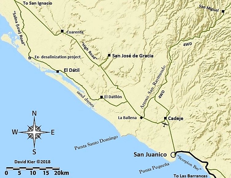
Does anyone have semi-current information on either or both of the two roads from San Juanico / Scorpion Bay north to Laguna San Ignacio? I'm interested in both the high road and the low road (through El Dátil).

David K - 2-3-2018 at 12:30 AM

Please see my trip reports for 2017. I traveled over 11,000 miles in Baja and posted the details, maps, mileages in the Nomad Baja Trip Reports forum. San Ignacio south was Trip #6, last August. It was easy, I drove the Salina route via El Datil.

David K - 2-3-2018 at 10:50 AM


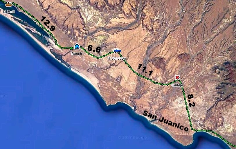
Here's my GPS track with mileages from San Juanico to El Datil:


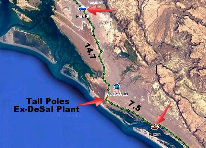
El Datil north to the junction with the high road:


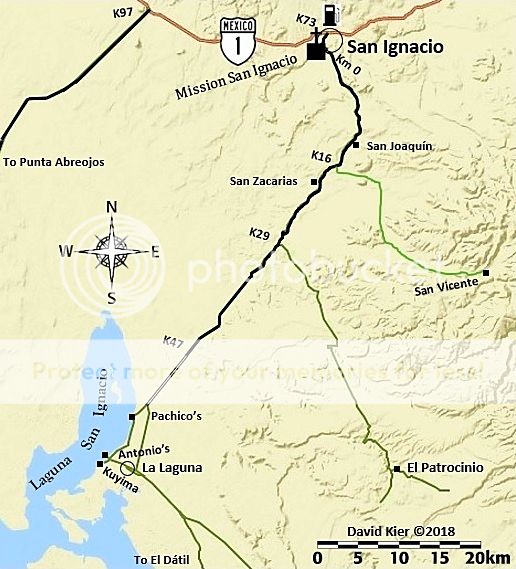
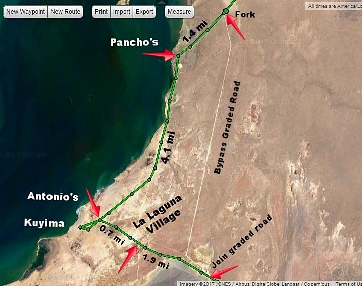
At Laguna San Ignacio:


----------------------------------------------------------------------------------------------------------------


TMW - 2-3-2018 at 12:30 PM

The high road north of El Cuarenta has been damaged by rain from a couple of years ago. I have not heard of anyone getting thru in the last year or two. Martin at the ranch told us to take the cut across rd to Los Batequis shown in Davids picture above. If anyone has been on it recently it would have been Nomad Desertbull and bikers probably.

Desertbull - 2-5-2018 at 09:14 AM

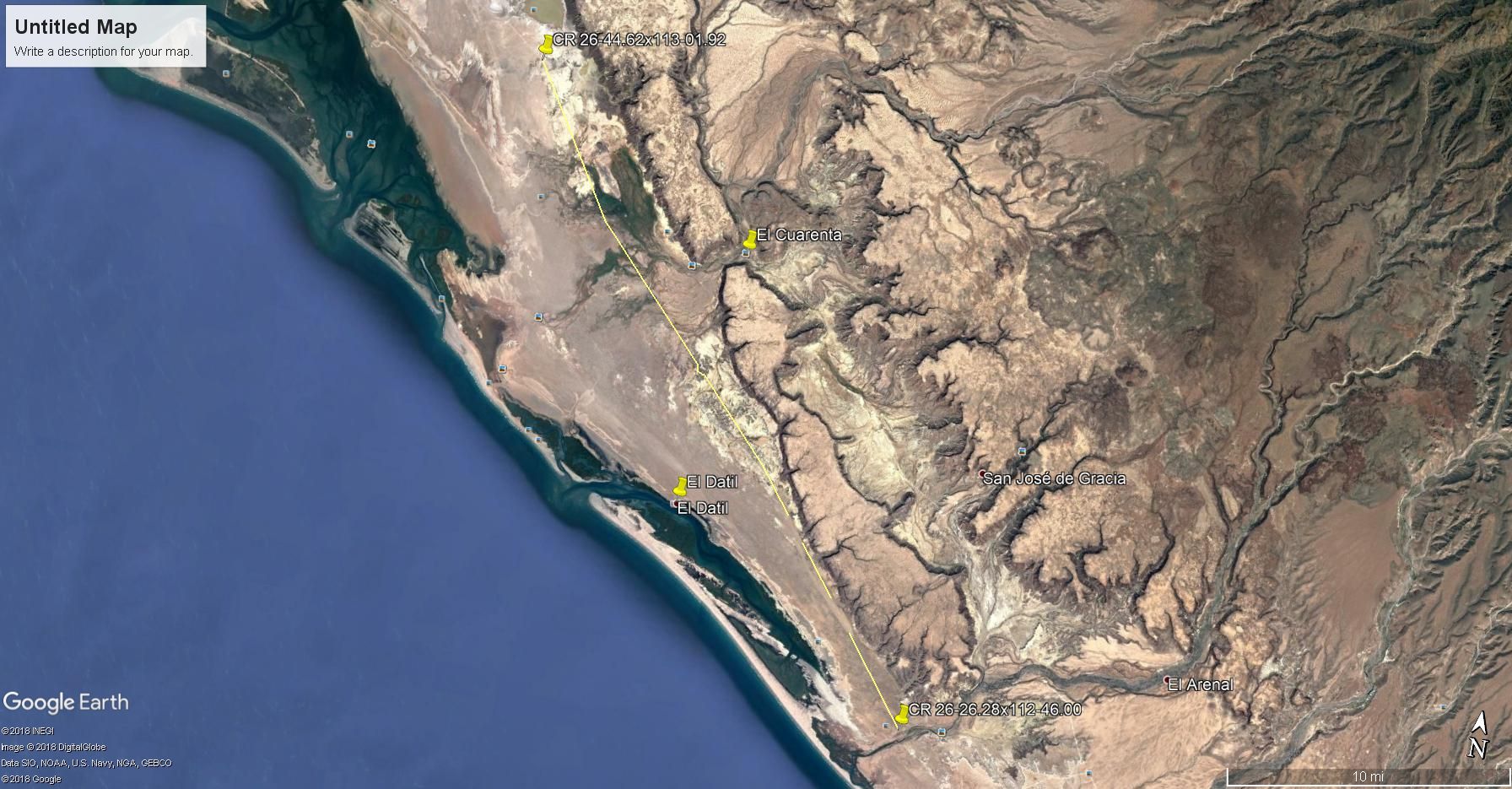
The high road is passable, but slow going. Something like 50+ washouts which force you to go around, into, over, through, each of them one way or another...from San Jose de Gracia the road is good as traffic to and from SJG is daily ... ... as listed on DK's map its named the High Road...the other trail listed is called "The Salt Flats" and DK is missing a road which we call the "Sand Highway" and splits them in half ... many think the Sand Highway is really a good road until we take them on the Salt Flats and run 60 mph all the way ... smoother then Mex Why 1 in Catavina. :lol::lol::lol: Enjoy and get out and explore. Stop in San Juanico for a cold beer! Sit on the beach and slow down. Life is good!
David K - 2-5-2018 at 10:21 AM

Thanks Tim.
About where does this "Sand Highway" join in (on the north and south ends)? It is not shown, as I did not see or hear of it before my trip last August, I was going by TW's notes before I let... not that I had the time to loop back over any more road that trip.

TMW - 2-5-2018 at 01:58 PM

I traced a road between 26-44.62x113-01.92 on the north end. It's a split off the main road south of the split to El Datil. This center road rejoins the main road from El Datil at 26-26.28x112-46.00. It appears to be a pretty straight road but I lost it in two sections in the bottom half. Google Earth was dated Jan 2015.

Maybe this is the road Desertbull was talking about.

Tomas Tierra - 2-5-2018 at 06:29 PM

That middle road is woopty doo city. Prolly fun on a bike but no bueno in a truck, a real camper scrambler. However it ican be the only option during/after rain. Better then when the sand is hard

I “heard” recently that the upper road is what “everybody” is using right now. Reputable source SJ local one month ago. FWIW

TT

Eatmorefish - 3-6-2018 at 10:32 AM

Desertbull, when you say the road is good and traffic is daily to and from SJG, is that from the north or south? Also, what's your opinion on making the trip, via the salt flats, w two wheel drive? A member of our small group has a vanagon. Thanks in advance.

David K - 3-6-2018 at 10:57 AM

fwiw, since I used the salt flat road, let me advise to keep to the inland edge route (rather than the shorter, cross flats route). Perhaps not do that way during full or new moon phases (for the tides) or after rain. The north end, near the fork with the high road was pretty rough washboard.

Desertbull - 3-6-2018 at 11:46 AM

if you have multiple vehicles and one is 4WD to give the other ones a short tow if they are stuck in the sand then yes, Vanagon good to go but only on the low route .. the Vanagon will not make it thru the middle route aka Sand Highway .... like DK says if the full moon and tide flood the low route might be tough on a Vanagon ... the locals do it daily but they have knowledge of ALL the routes ... even the low tidal route has 20 different variations of connecting trails ... and the locals know them all.

Quote: Originally posted by Eatmorefish  
Desertbull, when you say the road is good and traffic is daily to and from SJG, is that from the north or south? Also, what's your opinion on making the trip, via the salt flats, w two wheel drive? A member of our small group has a vanagon. Thanks in advance.

TheEL - 8-12-2018 at 09:47 PM

Ive heard that the north high road is great right now. Only a few spots of moondust. I think I'm gonna go for it this week unless someone has some newer info?

Last time I took the "sand highway." It was fine for me in an AWD van. Helped a guy get unstuck in his 2wd toyota sequoia. When we linked up with the last of the salt flats it was smooth sailing until the very last one where we chose poorly and didn't go all the way to the side of the flat. I made it through but my friend got high centered in his subaru outback. Digging him out was fun. yea... fun.

David K - 8-13-2018 at 11:16 PM

Quote: Originally posted by TheEL  
Ive heard that the north high road is great right now. Only a few spots of moondust. I think I'm gonna go for it this week unless someone has some newer info?

Last time I took the "sand highway." It was fine for me in an AWD van. Helped a guy get unstuck in his 2wd toyota sequoia. When we linked up with the last of the salt flats it was smooth sailing until the very last one where we chose poorly and didn't go all the way to the side of the flat. I made it through but my friend got high centered in his subaru outback. Digging him out was fun. yea... fun.


It has been many months since the previous post to yours. Desert Bull has said recently the high road is now the preferred route as road graders had made it very fast. When I went through the area 12 months ago, the high road had many reported washouts from floods and the Salina (low) road was preferred. If one stays to the inland edge tracks and doesn't short-cut across on the straight tracks, you will miss mud holes. Your choice... the low road is only a couple of miles longer than the high road... but best done in an SUV or truck, imo.

High tides and the low road

CarneAsada - 7-28-2019 at 04:55 PM

I'm headed down to San Juanico for the first week in August. It looks like the tides are going to pretty high that week (6-7 foot high tides). Do these kind of tides make the low road impassable?

David K - 7-28-2019 at 07:20 PM

Quote: Originally posted by CarneAsada  
I'm headed down to San Juanico for the first week in August. It looks like the tides are going to pretty high that week (6-7 foot high tides). Do these kind of tides make the low road impassable?


That is why there is a high road. It was re-graded after my trip 2 years ago when the low road was the only choice for most.

Mulege Canuck - 2-11-2020 at 07:00 PM

Anyone done the north low road on the tidal flats to San Juanico lately?

AKgringo - 2-11-2020 at 07:48 PM

How soon are you planning to drive the flats? The reason I ask, is because we are just past a few day of full moon tides, and I have seen areas flooded here in La Paz that are usually dry in normal tide cycles.

I drove from San Ignacio to San Juanico two weeks ago, but never got near the flats. I never found a need for putting the front axle to work, and did not find any truly hateful stretches of wash board.

Bajazly - 2-11-2020 at 08:12 PM

Week between Christmas and New Years was stellar and I don't think they have had any weather down there to make it sloppy. In fact, we were there after the rains in December and a lot of places we went were wet but the low road was fine.

Mulege Canuck - 2-12-2020 at 07:08 AM

I am planning on heading that way on Feb 20 th. Tides will be lower then. I drove that route last year on the flats and it was an easy drive with our camper.

Thanks for the information boys.

Mulege Canuck - 2-19-2020 at 07:13 PM

Just got back from San Juanico to San Ignacio on the tidal low road.

The gravel road from San Juanico to the El Datil turnoff was washboard with a few rough sections they have not repaired yet. No big deal for a Taco but was slow going with a F350 and camper.

Once on the salt flats the road was good but they have had some big tides there so make sure not to take any “Mexican shortcuts “ across the flats. Stay close to the vegetation and all will be good. Met a guy in San Ignacio who got stuck pretty bad on the flats. Maybe he cheated a little and got P-nched.

We stayed on the point past Camp El Delgadito. Not great spot for fishing but it is beautiful spot for kayaking at high tide with lots of bird life.


F4228CF7-A25E-40D1-AEF9-EB63EEF6F315.jpeg - 92kB

[Edited on 2-20-2020 by Mulege Canuck]

[Edited on 2-20-2020 by Mulege Canuck]

Ateo - 2-19-2020 at 10:52 PM

Nice report Mulege C. Gracias.

Stewwalker - 2-29-2020 at 08:10 PM

So is the most traveled road the west most road via El Datil? Planning on driving it in a few weeks.

Quote: Originally posted by David K  


Here's my GPS track with mileages from San Juanico to El Datil:


El Datil north to the junction with the high road:


At Laguna San Ignacio:


----------------------------------------------------------------------------------------------------------------


David K - 3-1-2020 at 09:40 AM

Stewwalker, when I did the trip (detailed on my maps above) it was August 2017. The El Datil/ Low or Salinas Road was the preferred route because the High Road had numerous washouts reported.

The year after my trip, Desert Bull reported that the High Road was repaired and regraded, offering super-fast speeds.

Now, I hear the high road is not so fast, once again... so it is 50/50 on which to use. The High Road is a tiny bit shorter but the Low Road is smoother... You just need to stay to the desert side of the salt flats and don't short cut across (mud danger) if you go that way.

There is sometimes a third route mentioned, but I can't help you with where it is in relation to the the two I have shown.

Howard - 3-1-2020 at 10:07 AM

So for us map challenged people, how many miles/KM is it from the lagoon to San Juanico? I only have around a 100 miles range in my RZR and could always bring spare gas. From S.J. all the way to the town of San Ignacio, is there anyone regularly selling gas and to really be fussy, hi octane? Like I said, I can always bring spare gas but it's a matter of how much to bring.

Anyone have mileage from the gas station at Highway #1 to S.J.? By memory, they sell at least regular octane in S.J., correct?

David K - 3-1-2020 at 10:29 AM

Quote: Originally posted by Howard  
So for us map challenged people, how many miles/KM is it from the lagoon to San Juanico? I only have around a 100 miles range in my RZR and could always bring spare gas. From S.J. all the way to the town of San Ignacio, is there anyone regularly selling gas and to really be fussy, hi octane? Like I said, I can always bring spare gas but it's a matter of how much to bring.

Anyone have mileage from the gas station at Highway #1 to S.J.? By memory, they sell at least regular octane in S.J., correct?


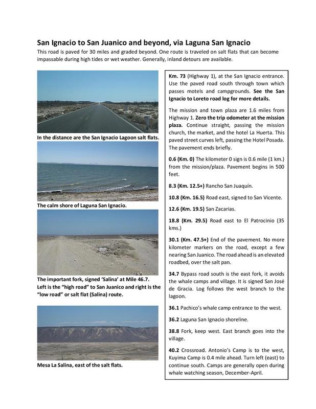
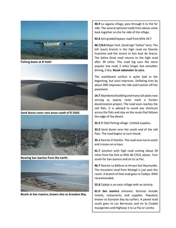
The maps go with my road logs... So here are the road log pages for San Ignacio to San Juanico. In a nutshell: San Ignacio to the lagoon is 36 miles and the Lagoon to San Juanico is 70 miles. Gas for sale was signed at El Datil in 2017.


Howard - 3-1-2020 at 10:46 AM

Thank you for the mileage.

AKgringo - 3-1-2020 at 01:34 PM

Quote: Originally posted by Stewwalker  
So is the most traveled road the west most road via El Datil? Planning on driving it in a few weeks.


What are you driving? Some vehicles do better than others on the flats.

chippy - 3-1-2020 at 01:46 PM

Quote: Originally posted by Howard  
So for us map challenged people, how many miles/KM is it from the lagoon to San Juanico? I only have around a 100 miles range in my RZR and could always bring spare gas. From S.J. all the way to the town of San Ignacio, is there anyone regularly selling gas and to really be fussy, hi octane? Like I said, I can always bring spare gas but it's a matter of how much to bring.

Anyone have mileage from the gas station at Highway #1 to S.J.? By memory, they sell at least regular octane in S.J., correct?


When I was there (San Juanico) in nov. my brother bought gas there. It was regular/verde but we never asked for hi/rojo. I bought diesel there also.

[Edited on 3-1-2020 by chippy]

TMW - 3-1-2020 at 02:25 PM

According to SCORE race notes it is approx. 105 miles from the PEMEX station on Hwy 1 in San Ignacio to where the road curves left at San Juanico.

Note this is going thru El Datil or using the salt flat road.

[Edited on 3-1-2020 by TMW]

JZ - 3-1-2020 at 02:45 PM

I'm going to trace a route of the Low Road on GE in a bit. Will posted it later.


Stewwalker - 3-1-2020 at 06:57 PM

Quote: Originally posted by AKgringo  
Quote: Originally posted by Stewwalker  
So is the most traveled road the west most road via El Datil? Planning on driving it in a few weeks.


What are you driving? Some vehicles do better than others on the flats.


The chase truck is a Raptor.

JZ - 3-1-2020 at 08:35 PM

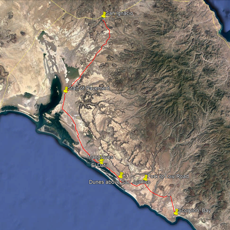
Here is a track of the Low Road. I mapped it trying to stay East as much as possible, where it looked like dryer areas.

Let me know if any errors. I've been up to Dunes above Scorpion Bay before, so up to there should be good.

Attachment: Scorpion Bay to San Ignacio.kmz (7kB)
This file has been downloaded 338 times


[Edited on 3-2-2020 by JZ]

[Edited on 3-4-2020 by BajaNomad]

mtgoat666 - 3-1-2020 at 09:18 PM

Quote: Originally posted by JZ  
Here is a track of the Low Road. I mapped it trying to stay West as much as possible where it looked like dryer areas.

Let me know if any errors. I've been up to Dunes above Scorpion Bay before, so up to there should be good.


[Edited on 3-2-2020 by JZ]


Classic baja nomad bs. You haven’t been there, but you post a route map based on satellite photo you found on the internet, and you chose the “dry-looking” roads :lol:

:lol:

[Edited on 3-2-2020 by mtgoat666]

[Edited on 3-4-2020 by BajaNomad]

JZ - 3-1-2020 at 09:51 PM

Quote: Originally posted by mtgoat666  


Classic baja nomad bs. You haven’t been there, but you post a route map based on satellite photo you found on the internet, and you chose the “dry-looking” roads :lol:

:lol:


Maybe you missed the KMZ? It's mapped from GE by following the road tracks, not an internet photo you retard. Then did a screen shot. Already had the first 30 miles from a previous trip.

I map out the tracks on GE of every trail we are going to hit before we take a trip. Export them to Back Country Navigator with offline HD satellite imagery. It's like watching your truck drive live on GE.

Gonna do this route next month.


[Edited on 3-2-2020 by JZ]

geoffff - 3-1-2020 at 10:27 PM

Quote: Originally posted by JZ  
I map out the tracks on GE of every trail we are going to hit before we take a trip. Export them to Back Country Navigator with offline HD satellite imagery. It's like watching your truck drive live on GE.


I do something very similar. Super fun to watch yourself from above!

-- Geoff

Mulege Canuck - 3-2-2020 at 04:51 PM

I would not recommend anyone doing that low road without a track or a plotted route before you head out. Lots of turns and junctions.

Last year we missed a turn and ended up on the “middle road” which is sugar sand. I was surfing the F350 and was very lucky to not get stuck or meet an on coming vehicle.

I use a navionics app to plot routes. I use the app for sailing my boat in BC off Vancouver Island but it works well in Baja for off-road stuff. When in doubt, go walk any shortcut across the mud or just play it safe and meander along the tidal edge.

Mulege Canuck - 3-2-2020 at 05:07 PM

Quote: Originally posted by Mulege Canuck  
I would not recommend anyone doing that low road without a track or a plotted route before you head out. Lots of turns and junctions.

Last year we missed a turn and ended up on the “middle road” which is sugar sand. I was surfing the F350 and was very lucky to not get stuck or meet an on coming vehicle.

I use a navionics app to plot routes. I use the app for sailing my boat in BC off Vancouver Island but it works well in Baja for off-road stuff. When in doubt, go walk any shortcut across the mud or just play it safe and meander along the tidal edge.


DA75D078-FD9D-45FB-A11F-D6A5F7C394EB.jpeg - 143kB

JZ - 3-2-2020 at 09:02 PM

Quote: Originally posted by geoffff  


I do something very similar. Super fun to watch yourself from above!

-- Geoff


It is incredibly cool! Blows my mind, cool.


Mulege Canuck - 3-3-2020 at 08:26 AM

Quote: Originally posted by Mulege Canuck  
I would not recommend anyone doing that low road without a track or a plotted route before you head out. Lots of turns and junctions.

Last year we missed a turn and ended up on the “middle road” which is sugar sand. I was surfing the F350 and was very lucky to not get stuck or meet an on coming vehicle.

I use a navionics app to plot routes. I use the app for sailing my boat in BC off Vancouver Island but it works well in Baja for off-road stuff. When in doubt, go walk any shortcut across the mud or just play it safe and meander along the tidal edge.


193598B8-07A4-4112-A785-CAED8F957336.jpeg - 118kB

Desertbull - 3-3-2020 at 09:35 AM

The path of least resistance is still the High Road via San Jose de Gracia road ... 2WD in my 20 year old Toyota Tundra easy peasy.

As Mulege Canuck says you better have the latest file from someone trust worthy ... I've towed many out of the tidal flat mud and the deep sand when they made the wrong turn ...

Every super moon changes the low tidal flats route ... and that was 2 weeks ago, pay attention, school is in session.

mtgoat666 - 3-3-2020 at 10:01 AM

Quote: Originally posted by Desertbull  
The path of least resistance is still the High Road via San Jose de Gracia road ... 2WD in my 20 year old Toyota Tundra easy peasy.

As Mulege Canuck says you better have the latest file from someone trust worthy ... I've towed many out of the tidal flat mud and the deep sand when they made the wrong turn ...

Every super moon changes the low tidal flats route ... and that was 2 weeks ago, pay attention, school is in session.


it also changes after every big rain storm...
areas like this have changed with sea level rise. just the centimeter-plus rise in past decade has seen changes (more frequent flooding) in the salt flats and mud flats at top of the tidal zone....

Stewwalker - 3-3-2020 at 07:05 PM

Quote: Originally posted by JZ  
Here is a track of the Low Road. I mapped it trying to stay East as much as possible, where it looked like dryer areas.

Let me know if any errors. I've been up to Dunes above Scorpion Bay before, so up to there should be good.


Damn near spot on from what I have. Could have saved you 500 clicks and sent you by file.


[Edited on 3-2-2020 by JZ]


[Edited on 3-4-2020 by BajaNomad]

JZ - 3-3-2020 at 07:32 PM

Quote: Originally posted by Stewwalker  


Damn near spot on from what I have. Could have saved you 500 clicks and sent you by file.


Now you tell me.

AguaDulce - 3-3-2020 at 09:42 PM

It does not really matter what you drive. I have been stuck in salt flats and have seen other vehicles stuck on the low road including a Raptor. When it is wet it will stop you. When dry it is smooth sailing. The high road is fine as of last month. If by accident you get on the "middle" road just drive as you should in heavy dry sand. I have told DK that there should not be an official map of a "road", as he has printed, of the low road as it always changes.

David K - 3-4-2020 at 09:25 AM

Quote: Originally posted by AguaDulce  
It does not really matter what you drive. I have been stuck in salt flats and have seen other vehicles stuck on the low road including a Raptor. When it is wet it will stop you. When dry it is smooth sailing. The high road is fine as of last month. If by accident you get on the "middle" road just drive as you should in heavy dry sand. I have told DK that there should not be an official map of a "road", as he has printed, of the low road as it always changes.


I don't think any map is "official"...? The maps I made or the GPS tracks of my trips are just that, tracks or maps of roads I traveled. A week later, a flash flood can change everything!

Any map or road guide is only accurate the day it was researched. The best we can have is the most recent map or road log with an understanding that you must use common sense and be flexible.

Taking the most well-traveled route (most recent tracks) is a wise idea when you reach a fork that is not included in a guide.
That was the rule when we drove from Tijuana to Cabo in 1966... and we didn't get lost or had to backtrack.

Just have fun... and remember, getting stuck or breaking down makes for the best stories later!

mtgoat666 - 3-14-2020 at 07:00 AM

The salt flats are a swamp today. The rain on Thursday really hit San Ignacio lagoon (and all of Sierra and vizcaino penn) hard, and the road from lagoon to San Ignacio is washed out. May be fixed sometime this weekend??