BajaNomad

Canyons

 Pages:  1  

PaulW - 3-25-2018 at 02:14 PM

Can anyone update the results of my study?
See the asterisk for questionable locations or names.

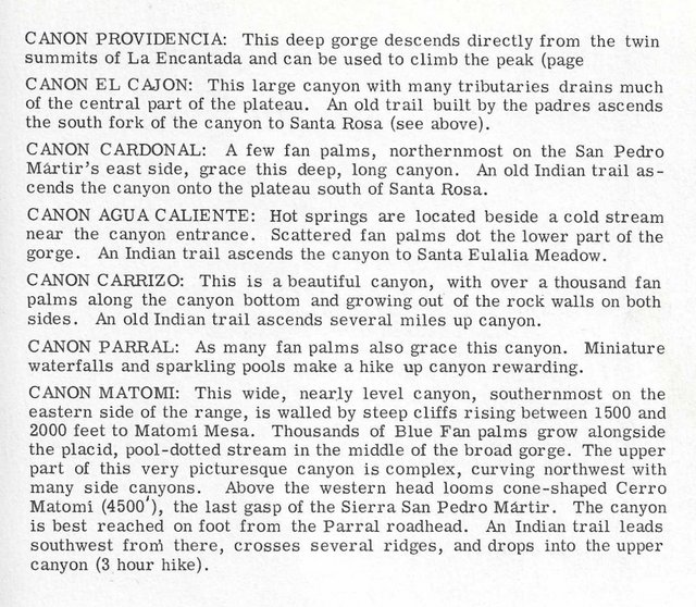
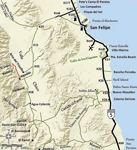
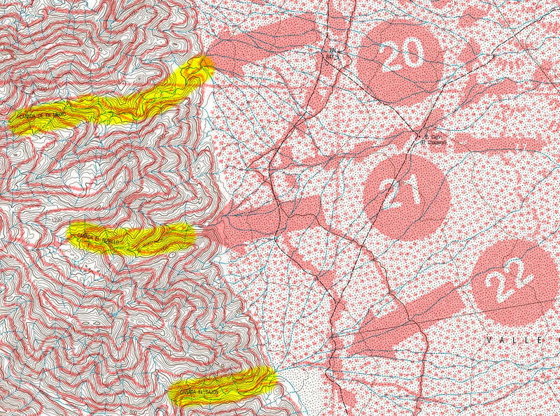
My study of canyons on the east side of San Pedro Martir. A work in progress
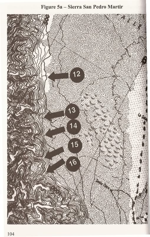
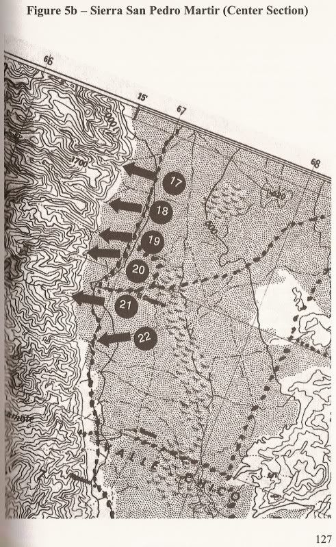
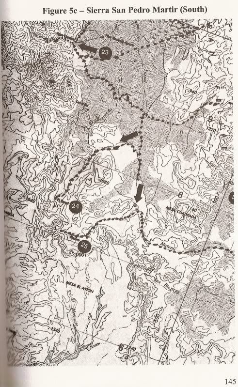
The order of the images start from the north


mtgoat666 - 3-25-2018 at 02:35 PM

For names of canyons, and some old (and outdated) trail info, Look at robinson’s Book. Also schaad map and inegi topos.

PaulW - 3-25-2018 at 02:39 PM

Those source have been used, including the Barber book. I have pretty much use all my ref material. Got most of the canyon locations from INEGI. Not easy to follow the drainage's from whee the darn things are labeled.

4x4abc - 3-25-2018 at 02:40 PM

http://www.beta.inegi.org.mx/app/biblioteca/ficha.html?upc=7...

http://www.beta.inegi.org.mx/app/biblioteca/ficha.html?upc=7...

http://baja101.com/BCTC/northone.html

mtgoat666 - 3-25-2018 at 02:48 PM

Quote: Originally posted by PaulW  
Those source have been used, including the Barber book. I have pretty much use all my ref material. Got most of the canyon locations from INEGI. Not easy to follow the drainage's from whee the darn things are labeled.


At the south end of SPM there is one canyon with a stock trail that has seen use recently (past decade), but probably abandoned by now, not sure if anyone runs stock or horses up that canyon anymore....

I think the only canyon frequently traveled is diablo, and then only by hikers bush-whacking,... would be fun to see a group volunteer to cut brush and keep the trail open,... it’s a good hike as it has reliable water, and if it were less bush-whacking it would be more attractive for hikers,... there are some other canyons that would make great hikes, but again, they are choked with brush so a bit of an ordeal to hike and scramble.

PaulW - 3-25-2018 at 03:02 PM

Goat,
That stock trail was used by Melling goes down the mountain to the Auga Caliente canyon entrance. And yes the trail is very overgrown. I have not heard of anyone going up that trail - just stories from the old days. Recently access to that canyon has not been allowed by the ranch owner of land at the entrance to the canyon.

PaulW - 3-25-2018 at 03:05 PM

Harald,
Thanks for the links, but I have all the maps I need that were previously downloaded.
For sure I kept and printed the Key on the last link.

David K - 3-25-2018 at 03:12 PM

Quote: Originally posted by PaulW  
Goat,
That stock trail was used by Melling goes down the mountain to the Auga Caliente canyon entrance. And yes the trail is very overgrown. I have not heard of anyone going up that trail - just stories from the old days. Recently access to that canyon has not been allowed by the ranch owner of land at the entrance to the canyon.

El Cajon Canyon was mentioned in the Meling Ranch history book.

PaulW - 3-25-2018 at 03:17 PM

I was recently told the the Melling cowboys have been to the upper reaches of El Cajon and Agua Caliente during the roundup where they try to locate all the free spirit cattle.
Compared to Agua Caliente El Cajon is a more difficult hike. It is very overgrown above the waterfall.

[Edited on 3-25-2018 by PaulW]

David K - 3-25-2018 at 03:58 PM

Did you ever meet the gringo Bob ('burro bob') who lived at the ranch house at the El Cajon canyon entrance? He used to post here about hiking up to the top of the mountain. It was a regular trail used by the Dominicans and Indians of Mission San Pedro Mártir.

Update: 'burro bob' was a heavy contributor here from June 2004 until Oct. 9, 2007, then just vanished from Nomad with no warning.

[Edited on 3-26-2018 by David K]

David K - 3-26-2018 at 01:00 AM

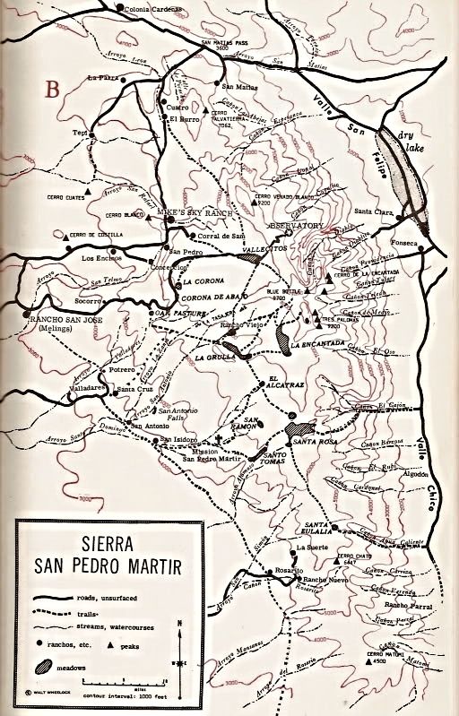
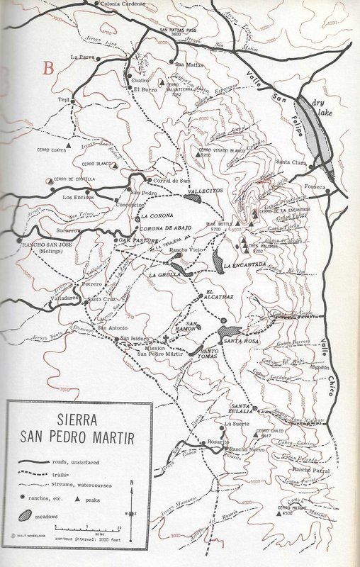
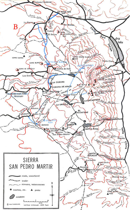
The first map with many canyons named was from 'Camping and Climbing in Baja' c1967 This was a revised map showing the new Observatory, the road there, and Mike's Sky Rancho... 1972 edition, I believe:


[Edited on 3-26-2018 by David K]

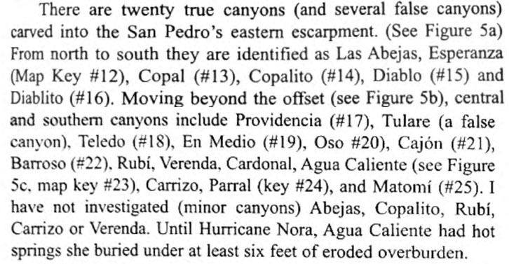
Bruce Barber Names the Canyons:

David K - 3-26-2018 at 01:21 AM

From Bruce's great book:
Of Sand and Sea...


12) Esperanza
13) Copal
14) Copalito
15) Diablo
16) Diablito


17) Providencia
18) Teledo
19) En Medio
20) Oso
21) Cajon
22) Barroso


23) Agua Caliente
24) Parral
25) Matomi

Comparison list

PaulW - 3-26-2018 at 08:50 AM


PaulW - 3-26-2018 at 10:43 AM

Quote: Originally posted by David K  
Did you ever meet the gringo Bob ('burro bob') who lived at the ranch house at the El Cajon canyon entrance? He used to post here about hiking up to the top of the mountain. It was a regular trail used by the Dominicans and Indians of Mission San Pedro Mártir.

Update: 'burro bob' was a heavy contributor here from June 2004 until Oct. 9, 2007, then just vanished from Nomad with no warning.

[Edited on 3-26-2018 by David K]

==== =
Not 'Burro Bob', but Rob K. who has property nearby. Rob does not live there but lives closer to town in the Ejido hosing area.

LukeJobbins - 3-26-2018 at 10:47 AM

I personally have not done the desert route up the devils canyon but it is hiked pretty frequently. I would guess 2 weekends at least out of every month. Sofia and I both want to do two different canyons up to picacho and Sofia wants to do all 7 routes up to picacho and write a book about them.

PaulW - 3-26-2018 at 12:38 PM

Quote: Originally posted by LukeJobbins  
I personally have not done the desert route up the devils canyon but it is hiked pretty frequently. I would guess 2 weekends at least out of every month. Sofia and I both want to do two different canyons up to picacho and Sofia wants to do all 7 routes up to picacho and write a book about them.

= ==
Two routes is a big deal.
7 routes would be really hard core. I have only read about 3 maybe 4 routes with success. Providencia is definitely an aid climb from my reading.
East approach can be dicey at the pendulum and/or the second pitch, but at times I have done both with no personal aids. Just used the old existing cable for the pendulum. With a full pack it gets to be a problem. I used a haul rope for the pack.

David K - 3-27-2018 at 01:01 PM

In reviewing older threads here on Nomad about Diablo and the canyons, etc. I read that the El Cajon Canyon Trail to the top was totally destroyed by one of the big storms.

Here it is from bajalou, in 2008:
Local Mexican friends have told me that the trail in Canon Cajon that had been used for many years was washed out and away by Hurricane Nora in 97. He said it is now impossible to traverse the canyon without some serious mountain climbing equipment and skills.

PaulW - 3-27-2018 at 05:15 PM

My last trip ended at the waterfall where the bushes became to dense to pass. Previously a year ago, I got to the old rock wall dam above the waterfall with difficulty. No sign of any kind of trail. Maybe further up?
One can drive thru the corral to the pila and park and walk the short distance to the water flowing over the rock (waterfall).

PaulW - 11-17-2021 at 09:25 AM

Update
I have not seen Rob K. ('burro bob') for some time. I will try to look him up. He helped me on a SCORE marking trip and gave me some help for Provedencia canyon when we were planning to do the climb. In time that all that all fell through. At our last contact he said he was still getting a stipend when the races pass through his property. Last time I saw him he was living in SF in the ejido with his elderly mother.
== ==

Quote: Originally posted by David K  
Did you ever meet the gringo Bob ('burro bob') who lived at the ranch house at the El Cajon canyon entrance? He used to post here about hiking up to the top of the mountain. It was a regular trail used by the Dominicans and Indians of Mission San Pedro Mártir.

Update: 'burro bob' was a heavy contributor here from June 2004 until Oct. 9, 2007, then just vanished from Nomad with no warning.

[Edited on 3-26-2018 by David K]

4x4abc - 11-17-2021 at 09:29 AM

will post the canyons later today

PaulW - 11-17-2021 at 09:36 AM

List for the canyons
The canyon list has not been updated. When I get around to it I will post it again since it is now missing.
Now that we have the composite of all the INEGI maps and the latest stuff from Benchmark I have slowly been making progress tracing the canyons. I will eventually come up with coordinates at each canyon entrance.
Meanwhile I have tried to convince Benchmark to use my list and I did locate the missing and incorrect canyons for Benchmark Neil. Otherwise, time will tell if I get my latest task for cords complete.

David K - 11-17-2021 at 09:40 AM

Quote: Originally posted by PaulW  
List for the canyons
The canyon list has not been updated. When I get around to it I will post it again since it is now missing.
Now that we have the composite of all the INEGI maps and the latest stuff from Benchmark I have slowly been making progress tracing the canyons. I will eventually come up with coordinates at each canyon entrance.
Meanwhile I have tried to convince Benchmark to use my list and I did locate the missing and incorrect canyons for Benchmark Neil. Otherwise, time will tell if I get my latest task for cords complete.


Sounds great... Neil and the crew at Benchmark are looking forward to a Second Edition with all of our submitted additions or corrections. I had lunch with Luis (Benchmark salesman) last week on his way to Baja. Really nice people work for Benchmark!

Cleaned up Canyon List

PaulW - 11-17-2021 at 04:19 PM

Not updated


The Canyon list.jpg - 150kB

4x4abc - 11-17-2021 at 05:00 PM

here is what I have


Attachment: all canyons.kmz (5kB)
This file has been downloaded 203 times

David K - 11-17-2021 at 05:18 PM

Paul, at your line 23 1/2 is Robinson's 'Verenda'... Given that the V and B in Spanish are very similar, it surely is an alternate spelling for Berrendo (Verrendo/ Berendo/ Verenda)??

He did not include Verenda in his guide's canyon descriptions, however. Just his map has it located where Berrendo is and a mention in the road log page.

I used Cardonal for La Gringa in my article and map, based on Robinson's excellent guide to them back in 1967:


My Baja Bound article: https://www.bajabound.com/bajaadventures/bajatravel/san_feli...


[Edited on 11-18-2021 by David K]

PaulW - 11-17-2021 at 06:17 PM

As you can see Harald and Atlas 21 both have two Novillo
I convinced myself one further north is wrong. The Almanac did not address the one to the north.
Cardonal needs further search. Harald shows it further west so the search begins there.
Good point about Verenda/Berrenda/Berrendo but the Verenda spelling is different


Canyon list revised.jpg - 158kB

David K - 11-18-2021 at 08:21 AM

A simple look at a topo map or satellite image will show you how many canyons there are.

In person visits or reading in books will let you know which ones are interesting. Flash floods have removed palm trees once found in greater numbers in some.


geoffff - 11-18-2021 at 12:28 PM

Did you add INEGI 50K to your list? INEGI seems pretty confused. This is what I see:

12: (same as your list)
13: Copal & Copalito
14: Diablito
15: Providencia
16: (unnamed)
17: (unnamed)
18: (unnamed)
19: (unnamed)
20: de en Medio
21: Novillo
22: Cajón
23: (same as your list)
24: (same as your list)
25: (same as your list)

geoffff - 11-18-2021 at 12:40 PM

Or maybe I am confused with your Bruce Barber numbering scheme? This is what I see when I overlay Bruce's Of Sea and Sand maps on INEGI 50k. What I see also seems to match Baja Alamanc, but not your numbering in your chart above. Am I confused somehow?


geoffff - 11-18-2021 at 12:55 PM

Likewise what I see when I line up Bruce's 13,14,15 on INEGI the numbers. I think I see Bruce's 13 pointing at Copal/Copalito and 14 pointing to Diablo/Diablito, unlike your chart:


geoffff - 11-18-2021 at 01:07 PM

David, you know I'm that kind of nerd :)

Here are the Bruce Barber numbered canyons again, but overlaid on Baja Almanac:


geoffff - 11-18-2021 at 01:42 PM

OK I think I see the problem. PaulW was faithfully following Bruce's text of Of Sea and Sand, but it looks like Bruce misidentifies most of the canyons with his numbers and arrows on his maps.


So I think we should just throw out Bruce's maps and numbering scheme :) They just confuse things!


[Edited on 11-18-2021 by geoffff]

David K - 11-18-2021 at 01:57 PM

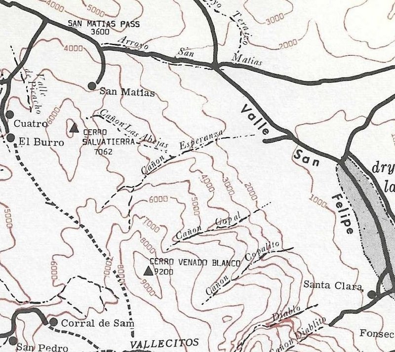
The 1967 John Robinson Map:


Just the canyons:


mtgoat666 - 11-18-2021 at 02:21 PM

Quote: Originally posted by geoffff  
OK I think I see the problem. PaulW was faithfully following Bruce's text of Of Sea and Sand, but it looks like Bruce misidentifies most of the canyons with his numbers and arrows on his maps.


So I think we should just throw out Bruce's maps and numbering scheme :) They just confuse things!


[Edited on 11-18-2021 by geoffff]


For the canyons and trails, The robinson and schad maps are pretty reliable. Ignore the others.

4x4abc - 11-18-2021 at 05:50 PM

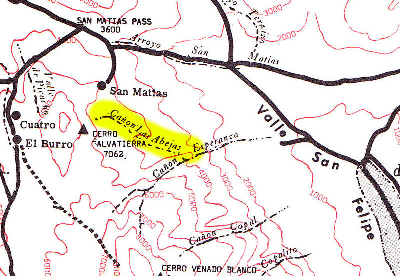
I have been searching the records for Cañon Las Abejas
no such thing in the area

PaulW - 11-18-2021 at 06:27 PM

GeoFFFF great images for me to follow.

Some comments – more later
Lots of INEGI issues for labels.
Bruces 13 The Copal/Copalito is an INEGI error. Disregard the lower Copalito label.
Bruces 14 For sure is Copalito
Bruces 15For sure is Diablo. Disregard the Dilabito label. Diablo has the distinctive U shape. Easy to prove when you chase the drainage way west then South. Also ignore the Provedencia label
Bruces 16 is Dilabito is the next one south. A short drainage
See my tracing for the above canyons
Bruces 17 is Provendicia and the darn canyon is on three INEGI maps. I do not have a compete trace, But the headwaters are at Diablo S summit should be easy to make a trace.


Geoffff said
Or maybe I am confused with your Bruce Barber numbering scheme? This is what I see when I overlay Bruce's Of Sea and Sand maps on INEGI 50k. What I see also seems to match Baja Alamanc, but not your numbering in your chart above. Am I confused somehow?

I say
My list is just a sequence. Only Bruce’ column has numbers. Yes, I think Bruce depended a lot on the Almanac. But he like me has the very old real INEGI maps to trace. Old maps prevail today with many of the same errors.

Geoffff said
Likewise what I see when I line up Bruce's 13,14,15 on INEGI the numbers. I think I see Bruce's 13 pointing at Copal/Copalito and 14 pointing to Diablo/Diablito, unlike your chart:

I say
Yes, Bruce had it figured out, just like I did. Recognize the label errors and just follow the drainages. He just missed Tulare


Attachment: phpo7W4IA (326kB)
This file has been downloaded 131 times

geoffff - 11-19-2021 at 09:39 AM

Quote: Originally posted by 4x4abc  
I have been searching the records for Cañon Las Abejas no such thing in the area


I was thinking the same thing, but I just found one on the 1967 John Robinson map:


David K - 11-19-2021 at 10:24 AM

You know, Geoff, the MapBox maps (when zoomed in) are pretty good topo maps that clearly show each canyon.

Maybe add the name(s) the various authors/ cartographers to each of these... It would be really visual!

I can do this at some point, but will be busy for a couple of says as we are doing the family Thanksgiving feast this weekend to avoid crowds and chaos of next week!

PaulW - 11-19-2021 at 10:45 AM

I just traced all the drainages in that area and. . .
Nothing similar coming off labeled Esperanza on the INEGI topo.
However, there are two major drainages. The northly one is probably Esperanza as it is much larger, but the southern one has the label.
The two are connected the desert valley end.
My suspicion is the northern one is Esperanza and that leaves the southern one available for a canyon label ?? Abejas
Checkout my suspicions.

geoffff - 11-19-2021 at 10:55 AM

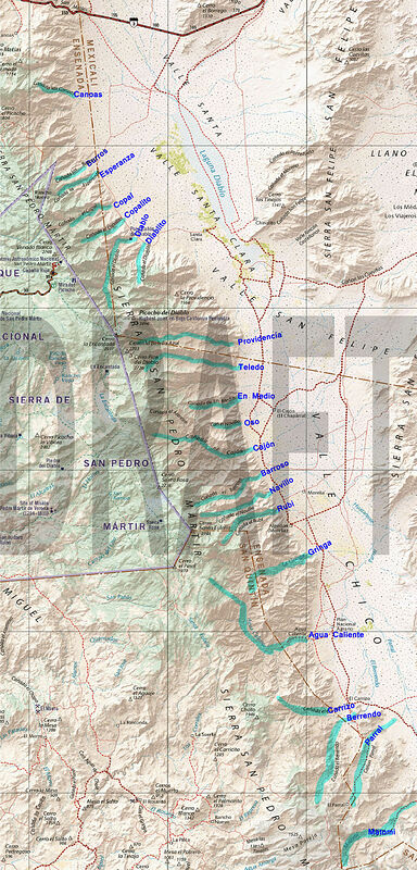
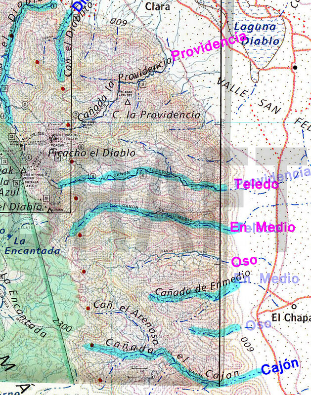
Here is my first attempt to understand and compile all PaulW's notes. How is this? What needs correcting?


PaulW - 11-19-2021 at 10:58 AM

Maps must have accurate topo lines to find canyons. Then the drainage likes can be followed. Zooming in on the INEGI topos would be great and are the primary source.
I do it the old-fashioned way with original INEGI maps with blue drainages and surrounding mountains and cliffs. Pretty easy for experienced map readers. Been doing it like that for 60 years and never got lost or even walked up the wrong canyon.

PaulW - 11-19-2021 at 11:02 AM

geoffff
Canyon layer looks perfect

geoffff - 11-19-2021 at 11:11 AM

Quote: Originally posted by PaulW  
Maps must have accurate topo lines to find canyons. Then the drainage likes can be followed. Zooming in on the INEGI topos would be great and are the primary source.
I do it the old-fashioned way with original INEGI maps with blue drainages and surrounding mountains and cliffs. Pretty easy for experienced map readers. Been doing it like that for 60 years and never got lost or even walked up the wrong canyon.


Paul, I have INEGI 50k and the old INEGI 50k hidden above, but I was looking at them when I made the above map and traced the drainages. My highlights are a compromise between INEGI and Baja Almanac -- that's why they are sometimes wider than normal.

Here is the above map on INEGI and Old INEGI. Click to open (huge images)


PaulW - 11-19-2021 at 11:13 AM

Abjeas?
I said:
I just traced all the drainages in that area and. . .
Nothing similar coming off labeled Esperanza on the INEGI topo.
However, there are two major drainages. The northly one is probably Esperanza as it is much larger, but the southern one has the label.
The two are connected the desert valley end.
My suspicion is the northern one is Esperanza and that leaves the southern one available for a canyon label ?? Abejas
Checkout my suspicions.
See my attached trace for Esperanza

Crop.jpg - 257kB

geoffff - 11-19-2021 at 11:15 AM

And here is my above map overlaid on Baja Almanac and Benchmark:


4x4abc - 11-19-2021 at 11:16 AM

Las Abejas is on David's map

David K - 11-19-2021 at 12:01 PM

Beautiful work, Geoff!
Abejas is the northernmost canyon in the 1967 Robinson map..

David K - 11-19-2021 at 01:49 PM

Quote: Originally posted by geoffff  
Quote: Originally posted by 4x4abc  
I have been searching the records for Cañon Las Abejas no such thing in the area


I was thinking the same thing, but I just found one on the 1967 John Robinson map:


Geoff, you have a newer edition printing of the book, and the arroyos/ canyons shown do not match with the topographic lines for them.


You can see the later printing has things shifted south a bit... I noticed this some years ago having compared various printings of Robinson's great little book.

[Edited on 11-19-2021 by David K]

PaulW - 11-19-2021 at 01:52 PM

Like I said there is nothing similar to what Robinson shows.
Chalk it up and an error on his part.
Just look at the topo and prove it for yourself like I did.


[Edited on 11-19-2021 by PaulW]

geoffff - 11-19-2021 at 05:02 PM

Quote: Originally posted by PaulW  
Like I said there is nothing similar to what Robinson shows. Chalk it up and an error on his part. Just look at the topo and prove it for yourself like I did. [Edited on 11-19-2021 by PaulW]


Yeah, I have to agree. And his Esperanza seems off as well.

Quote: Originally posted by David K  
Geoff, you have a newer edition printing of the book, and the arroyos/ canyons shown do not match with the topographic lines for them.


Hah, you're right! Somehow I hadn't quite figured out why his map was hurting my brain so much.

geoffff - 11-19-2021 at 05:13 PM

Quote: Originally posted by David K  
I just emailed you the old map scan!


Thank you!

Yeah, I have the 1979 edition it turns out.

geoffff - 11-19-2021 at 06:00 PM

And if you're curious about what changed on that map between 1967 and 1979 (excluding the misprinted red topo lines)... New 1979 stuff in blue:


4x4abc - 11-20-2021 at 12:48 AM

Cañon Esperanza in this last map image is a major canyon
It has no name on INEGI it has no name on our last name lists

I am surprised that an expansive canyon like that should have no name

Screen Shot 2021-11-20 at 12.38.19 AM copy.jpg - 242kB

David K - 11-20-2021 at 09:15 AM

Quote: Originally posted by geoffff  
And if you're curious about what changed on that map between 1967 and 1979 (excluding the misprinted red topo lines)... New 1979 stuff in blue:


Cool... since you did a nice comparison, let me add: Mike's Sky Ranch was placed too far east by Robinson (or Wheelock). It is actually closer to the 'San' in Arroyo San Rafael, north of Los Encinos (where Mike's original airstrip was).

4x4abc - 11-20-2021 at 10:07 AM

mapping is a very difficult task
especially when you don't have many local records


the amount of names for Arroyos, Cerros, Lomas, Sierras, Puntas, Ensenadas and other features indicates how actively an area is used or has been used
OR NOT

the eastern slope of Sierra San Pedro Martir has only been used to travel through (mainly indians, some explorers since missionary times)
not many routes are suitable for traversing
no significant ranching or farming took place
thus there re only a few names for Arroyos/Cañadas and Cerros (even though there are some significant peaks and valleys present)
and since few people live in the area, locations and names are sketchy

adventurous expats might straighten things out - if they would only learn to spell established names right

mtgoat666 - 11-20-2021 at 10:23 AM

Quote: Originally posted by 4x4abc  
mapping is a very difficult task
especially when you don't have many local records


the amount of names for Arroyos, Cerros, Lomas, Sierras, Puntas, Ensenadas and other features indicates how actively an area is used or has been used
OR NOT

the eastern slope of Sierra San Pedro Martir has only been used to travel through (mainly indians, some explorers since missionary times)
not many routes are suitable for traversing
no significant ranching or farming took place
thus there re only a few names for Arroyos/Cañadas and Cerros (even though there are some significant peaks and valleys present)
and since few people live in the area, locations and names are sketchy

adventurous expats might straighten things out - if they would only learn to spell established names right


The world is full of unnamed drainages/canyons. Perfectly OK for canyons to be unnamed.
In the scheme of things, probably logical to name only the canyons that have usable surface water or trails (I.e. the visited/used canyons).

Why the obsession to record names for all the canyons?


4x4abc - 11-20-2021 at 11:16 AM

Quote: Originally posted by mtgoat666  


Why the obsession to record names for all the canyons?


that is a fundamental question

the basis of science is to collect as many data as possible - then you figure out what to do with it

the cartographer is covered in the "Little Prince"
chapterXV
https://www.sparknotes.com/lit/littleprince/section5/

4x4abc - 11-20-2021 at 11:20 AM

Quote: Originally posted by mtgoat666  


Why the obsession to record names for all the canyons?


why does your country, your city, the street you live on have a name?
why do you have a name?


PaulW - 11-20-2021 at 12:35 PM

List update with many corrections

Canyon List.jpg - 163kB

geoffff - 11-22-2021 at 10:22 AM

Excellent Paul!

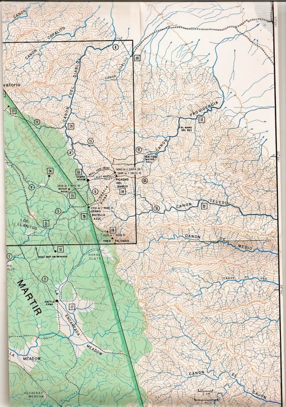
Is this the "Schad-Diablo" map you are using above?


PaulW - 11-22-2021 at 10:30 AM

Yes, I have downloaded all the images that Schad had on his brochure and originally on his web site.
Pretty old but he sure had very good topo detailed map back then.
My image detail is like your post.
If you don’t have the complete images from his climbing brochure, I can forward them to you.

geoffff - 11-22-2021 at 10:38 AM

Quote: Originally posted by PaulW  
Yes, I have downloaded all the images that Schad had on his brochure and originally on his web site.
Pretty old but he sure had very good topo detailed map back then.
My image detail is like your post.
If you don’t have the complete images from his climbing brochure, I can forward them to you.


I would love that, thanks!

geoffff - 11-22-2021 at 10:40 AM

My attempt earlier to make a visual map of PaulW's canyon naming seems to not have the canyon names line up with Schad's map for Providencia, Toledo, En Medio, Oso.

Am I incorrect, or is Schad?


geoffff - 11-22-2021 at 11:01 AM

I suspect I didn't follow your descriptions well for these canyons. How about these corrections (in Magenta) if I follow Schad's map? (Overlay also shows Baja Alamanc.)


[Edited on 11-22-2021 by geoffff]

geoffff - 11-22-2021 at 10:29 PM

PaulW was kind to share with me his scans of the Jerry Schad maps of the Picacho del Diablo area. I (mostly) stitched them back together. Click links or images to open full size:


1988--Picacho-Del-Diablo--Jerry-Schad-Map--Baja-California--Front.jpg


1988--Picacho-Del-Diablo--Jerry-Schad-Map--Baja-California--Back.jpg

PaulW - 11-23-2021 at 07:38 AM

Yes, Now you have the map correct with the Magenta labels
== ===
Quote: Originally posted by geoffff  
I suspect I didn't follow your descriptions well for these canyons. How about these corrections (in Magenta) if I follow Schad's map? (Overlay also shows Baja Alamanc.)


[Edited on 11-22-2021 by geoffff]

PaulW - 11-23-2021 at 07:59 AM

The pencil notes on Schad’s Brochure were made Summer 1999 and my climb was made March 11-16 2000
My first article was https://climber.org/reports/2000/651.html
The Nomads post was http://forums.bajanomad.com/viewthread.php?tid=67441#pid8316...
Found the source for Schad’s 1988 map http://dankat.com/swhikes/maps/devil.htm

=== ==
Quote: Originally posted by geoffff  
PaulW was kind to share with me his scans of the Jerry Schad maps of the Picacho del Diablo area. I (mostly) stitched them back together. Click links or images to open full size:


1988--Picacho-Del-Diablo--Jerry-Schad-Map--Baja-California--Front.jpg


1988--Picacho-Del-Diablo--Jerry-Schad-Map--Baja-California--Back.jpg

geoffff - 11-23-2021 at 11:21 AM

Quote: Originally posted by PaulW  
The pencil notes on Schad’s Brochure were made Summer 1999 and my climb was made March 11-16 2000
My first article was https://climber.org/reports/2000/651.html
The Nomads post was http://forums.bajanomad.com/viewthread.php?tid=67441#pid8316...
Found the source for Schad’s 1988 map http://dankat.com/swhikes/maps/devil.htm


Wow! I did come across your climbing web page, but didn't put 2 and 2 together that you were the same PaulW!

geoffff - 11-23-2021 at 11:29 AM

OK, here is my latest canyon map.

The only canyon that still worries me is "En Medio". The Jerry Schad map (& Bruce Barber, and Robinson) show EnMedio where PaulW indicates. Other resources (INEGI, Baja Almanac, Benchmark) indicate it as being just south of Oso, rather than just north of it. But PaulW's canyon is a more significant canyon than the INEGI one.


[Edited on 11-23-2021 by geoffff]

geoffff - 11-23-2021 at 11:31 AM


Canyon location Conflicts

PaulW - 12-2-2021 at 10:57 AM

Examining the list it is clear that the consensus are following Robinson’s list.
My research indicates Barber was the lead to establish the consensus. However, locating a canyon with a name is hit and miss. INEGI is the only current source, and they have plenty of errors. My latest list identifies all the canyons that have been named. Sure, would be good if we could locate maps like INEGI that are older than Robinson’s 1967 version. Using the INEGI site, the oldest maps are series 1 dated 1974. Barber had very old INEGI maps. He gave them away, but the new owner cannot be located.
Geofff pointed out the disagreement between the canyon locations of EnMedio and Novillo. The locations of the mouths of the canyons and the coordinates verify his assessment. Here are accurate coordinates:
Provendincia INEGI 31 1.862, -115 17.895
Toledo 30 57.731, -115 14.934 No help from INEGI this is my assessment
En Medio 30 57.74, -115 14.98 No help from INEGI this is my assessment
OSO 30 55.136, -115 15.063 No help from INEGI this is my assessment
En Medio INEGI 30 54.539, -115 14.944 No help from INEGI this is my assessment
Novillo INEGI 30 52.852, -115 14.659 Surprised (such a minor canyon has an INEGI name)
Cajon & Arenoso INEGI 30 51.296, -115 14.012
Novillo feeding Huatamote INEGI 30 47.686, -115 11.956 (The larger of the tow Novillos canyons)
Rubi and/or Cardinal INEGI 30 47.661, -115 11.947
Bottom line is there is no resolution of any conflict.


RCanyon-Lists.jpg - 142kB

Skipjack Joe - 12-2-2021 at 12:17 PM

Quote: Originally posted by 4x4abc  
Quote: Originally posted by mtgoat666  


Why the obsession to record names for all the canyons?


why does your country, your city, the street you live on have a name?
why do you have a name?


Why bother with Taxonomy?

geoffff - 12-3-2021 at 11:09 AM

Quote: Originally posted by mtgoat666  
Why the obsession to record names for all the canyons?


Hi Mt Goat, I do it simply because it's fun (for me) to obsess about these kinds of little details. I realize most people wouldn't care.

geoffff - 12-3-2021 at 11:49 AM

Quote: Originally posted by PaulW  
Bottom line is there is no resolution of any conflict.


Thanks, Paul. Unsatisfying, but I think you're right. I will keep my eye out for more old maps that might help indicate one way or the other.

Maybe someone would be up for taking a little field trip to ask a local rancher!?

-- Geoff


[Edited on 12-3-2021 by geoffff]

David K - 12-3-2021 at 12:01 PM

'Locals' often had not lived there when these places were named, and adopt their own names if the original was not preserved.

The same is true for history of a place.

There is history where I live, but living here doesn't make me an expert automatically... I find history in books, and maps from the time places got their names.

The canyons and arroyos are a fun project to clear up. I am all in for whatever I can provide.

4x4abc - 12-3-2021 at 12:02 PM

local ranchers are not a good source for accurate names.
They tell you the one they have been using in their family.
Ranchers the next valley over might not agree
INEGI might not agree

geoffff - 12-3-2021 at 01:45 PM

Hah! Good to know. I wouldn't have realized that.

geoffff - 12-3-2021 at 02:43 PM

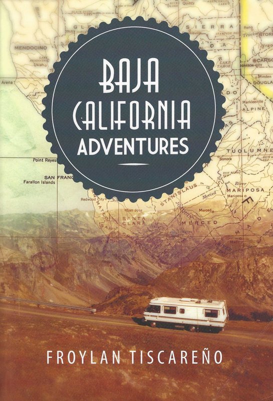
Froylan Tiscareno's 2013 book "Baja California Adventures" is surprisingly interesting, despite its cover (which shows a huge lumbering RV-park-queen driving some paved road).

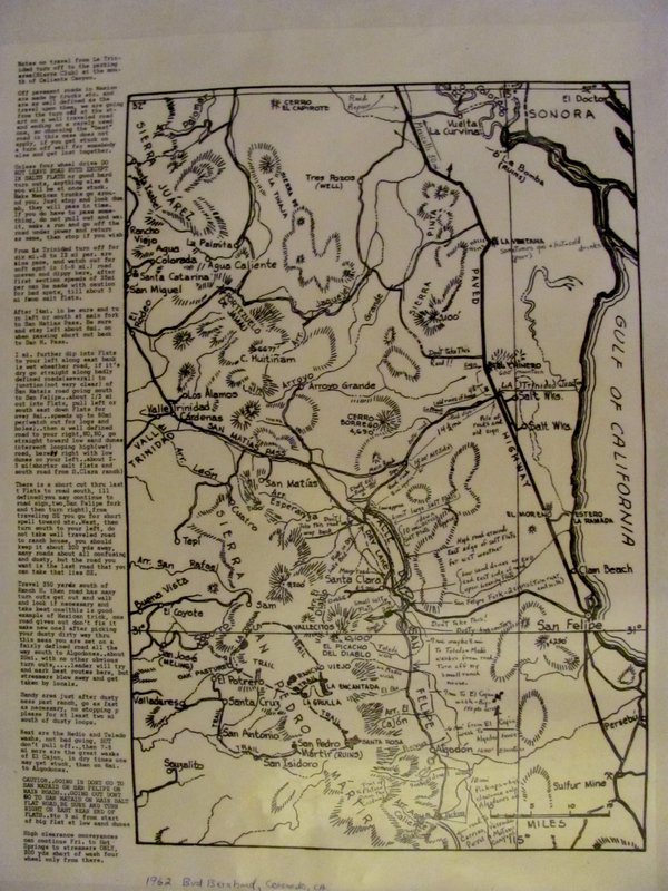
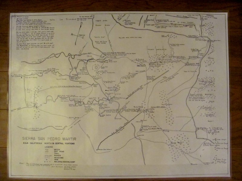
He tantalizingly mentions an intriguing map of these canyons by the famous Bud Bernhard.

Quote:
All of us had the opportunity to outfit ourselves with two maps of the area: one by F. H. Olmstead (500-foot contours) and the other by Bud [Bernhard]. This latter, though admittedly less formal in topographic details, was valuable for all the other information that Bud compiled out of his overstuffed brain when the Sierra Club asked him in 1963. Many of the notes on the map are intriguing (spooky?):

“Site of mysterious stone steps” (Copalito Canyon)
“Stones fly at night” (San Pedro Mártir mission cemetery)
“Site of burning bush” (Socorro Mine)
“Strange burial hole of Indian artifacts” (El Cajon Canyon)

Some of the warnings about road conditions are out of date but include the following:

“Road dangerous for all vehicles”
“Low-gear, high-clearance trucks only”
“Absolute limit of all auto travel”

One might imagine an inhospitable country when he read the following:

“Water in Spring only”
“Bad trail”
"4-1/2 to 5 hours Los Llanitos to La Grulla”

But there are also hints of the rewarding side:

“At least 5,000 palms in these three canyons” (Barroso, Carrizo, Parral)
“Big trout” (La Grulla, San Antonio)
“Small trout” (La Zanja arroyo)


Anyone know how to get in contact with Froylan Tiscareno on the small chance he still has this map around?

I tried an email address I found but it bounced.


[Edited on 12-3-2021 by geoffff]

Maderita - 12-3-2021 at 03:21 PM

geofff,
https://obits.ocregister.com/us/obituaries/orangecounty/name...

geoffff - 12-3-2021 at 03:29 PM

Quote: Originally posted by Maderita  
geofff,
https://obits.ocregister.com/us/obituaries/orangecounty/name...


Sad, but not surprising. Thank you

David K - 12-3-2021 at 05:31 PM

Froyland's 2013 book is great... a detailed summary of his travels by foot, horseback, and 4x4 from 1962 to 2008. Primarily in the Sierra San Pedro Mártir and the canyons.

The cover of his 'Baja California Adventures' was simply a generic cover for any travel story books published by Xlibris (yes, a terrible cover for a book that has nothing to do with motorhomes and paved highways).


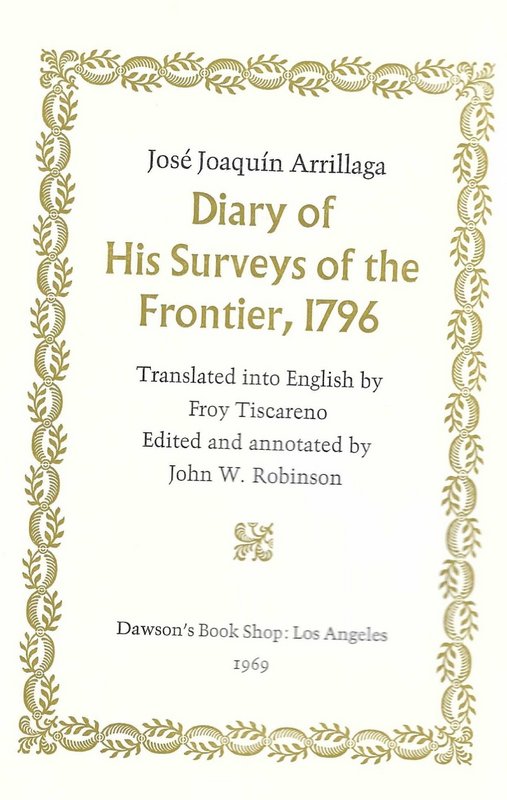
Froyland also has translated three historical books in the 51 volume Dawson Baja California Travels Series...

#17 José Joaquin Arrillaga, 1796 Diary (in 1969).
#43 The Natural History of Baja California by Miguel del Barco (in 1980).
#44 Ethnology and Linguistics of Baja California by Miguel del Barco (in 1981).


Look who helped Froyland translate: Camping and Climbing in Baja author, John Robinson.

Vince - 12-4-2021 at 10:31 AM

David, thanks for alerting me about this thread on the canyons on the eastern slope of the SPM mountains. I took four trips with Bud Bernard to the SPM in the 1950's starting in '53. I was in high school then as were some of my friends who were with us. Also a group of Sierra Club folks, we were all hiking and we started at the Meling ranch during Easter week. Phil Meling and some wranglers came on 2 trips that we rode horses. Bud would run ahead on foot and meet us at the next camp site. One of those trips that Bud led was from the desert side up Diablo canyon in about 1959. This was a dedicated mountain climbing trip with some good climbers along. Bud wanted to measure both peaks of Picacho del Diablo and took a device along on his back to do it with, a transit, I believe. The canyon was beautiful, the first day we had to leave our packs, swim across a clear pond at the bottom of a waterfall and climb up a cliff alongside the waterfall. We belayed our packs over the water with a rope we brought and got them all across. It took two days going up to the summit camp, one day to summit and the same going back. I forget which peak was higher, but one was about 6 or 8 feet higher than the other one as measured by Bud. We climbed both peaks to figure it out. As for the other guys you mentioned, they were not with us and I did not know them. Those were great personal memories and I am reminded of them every time I fly or drive past Picacho del Diablo.

[Edited on 12-4-2021 by Vince]

4x4abc - 12-4-2021 at 11:10 AM

Quote: Originally posted by David K  


Froyland also has translated three historical books in the 51 volume Dawson Baja California Travels Series...


Look who helped Froyland translate: Camping and Climbing in Baja author, John Robinson.


Camping and Climbing in Baja triggered my very first Baja exploration in 1986 - finding Cañon el Palomar and locating Pole Line Road. I got lost so badly that my girlfriend showed up 3 days late for work.

anza 2 300 GD.jpg - 192kB

David K - 12-4-2021 at 11:11 AM

Thanks for sharing the story Vince.

What would have happened to Bud's map, do you think? The map mentioned by Froy in his book (quoted by geoffff above).
Did he have children who may still have it?

Where is Abejas

PaulW - 12-4-2021 at 12:39 PM

Abejas
Interesting canyons with no labels or discussion
Using CalTopo for coords, Using blue lines I call Grid when dealing with INEGI paper or downloaded topo’s.
Grid numbers are on the vertical right side of the Topo. Horizontal Grid numbers are ignored.
From the north Canyon on H11B45
Grid 57/58 No INEGI label. Mouth at 31 14.607, -115 26.915 A big canyon. Partly on H11B35.
Grid 55 Canos, with INEGI label. Mouth at 31 13.268, -115 27.149 A small canyon
Grid 53/54 No INEGI label. Mouth at 31 12.215, -115 26.987 A big canyon
Grid 45 Esperanza, with INEGI label. Mouth at 31 8.3, -115 25.34 A small canyon

Where is Abejas - A side canyon of a larger canyon pointing W or NW? Consider:
It is possible it is at canyon Grid 57/58 It has a pretty good side leg pointing west on H11B35.
It is not at Grid 55, Canos. A small canyon with no significant side leg like Robinson describes.
It is possible it is at canyon Grid 53/54. It has three legs one of which points quite a way west
It is not at Grid 45, Esperanza. A small canyon with no significant spur like Robinson describes.

Speculation -- Abejas could be a leg on Grids 53/54 or 57/58. Should the choice be called Esperanza per Robinson?
Of course, then we all have been hiking up the wrong Esperanza and INEGI would have another wrong label.

Of course, Robinson could have possibly made a mistake with his label?

See a shot of my tracings below, black = ridges, red = drainage. Base map is most recent download from INEGI

Grid 57/58


Grid 57-58.jpg - 135kB
Grid 53/54


Grid 53-54.jpg - 139kB
Grid 45

Grid 45.jpg - 173kB

Vince - 12-4-2021 at 01:00 PM

Bud Bernard had no heirs, he was quite eccentric and never married and his only sibling, a sister, died before he did. He continued to go to the Meling ranch and lead people on trips but if it was hot, he would be incapacitated and had to be evacuated. Mrs. Meling finally asked him to not come in the summer. I do not know what happened to his belongings of which he had very few. As time went by, he became more eccentric and would not pay his taxes on his house in Coronado and it was confiscated by the county. His father was a retired WWl admiral and Bud inherited a very nice home. Bud was a tail gunner on a B-17 in WWll, was shot down and he parachuted to friendly forces. I will ask the person who bought his mansion from the county to see if she found any belongings, such as a map. I remember he talked about the canyons and access to climbing Picacho, but I never saw his map.


David K - 12-4-2021 at 01:59 PM

Quote: Originally posted by Vince  
Bud Bernard had no heirs, he was quite eccentric and never married and his only sibling, a sister, died before he did. He continued to go to the Meling ranch and lead people on trips but if it was hot, he would be incapacitated and had to be evacuated. Mrs. Meling finally asked him to not come in the summer. I do not know what happened to his belongings of which he had very few. As time went by, he became more eccentric and would not pay his taxes on his house in Coronado and it was confiscated by the county. His father was a retired WWl admiral and Bud inherited a very nice home. Bud was a tail gunner on a B-17 in WWll, was shot down and he parachuted to friendly forces. I will ask the person who bought his mansion from the county to see if she found any belongings, such as a map. I remember he talked about the canyons and access to climbing Picacho, but I never saw his map.


That is quite some history!
Thanks for the attempt to solve a lost map mystery!

Do you have any tales about Myron Smith? His son, Brooks, was a very interesting Baja Nomad, but died young. His Nomad name was Baja Taco at first, then edited to 'Taco de Baja', as there was another 'Baja Taco' on Nomad (he drove a Tacoma, or 'Taco').

I met Brooks at the entrance to Parral Canyon as he and his (also Nomad) friends were going to hike up Matomi Canyon. They had just hiked to Mission San Pedro Mártir with Baja Nomad Jack Swords (April 2004).


(L to R) Baja Taco, Huddo, Mexitron, and Pappy

I made a web page of their hikes in Baja: http://vivabaja.com/mexitron/

Vince - 12-5-2021 at 05:34 PM

No, no stories about those guys, I didn't know them. Looks to be an interesting chapter on Baja hiking and climbing. Bud did some good work when he rescued the Kellogg kid, Ogden, and his girlfriend, Eleanor Dart (O'Bryon). Eleanor wrote a book, which I have, Coming Home from Devil Mountain, all about their rescue when they got lost climbing Picacho del Diablo in 1967. I think I will read it again.

JZ - 12-5-2021 at 09:00 PM

Awesome thread.


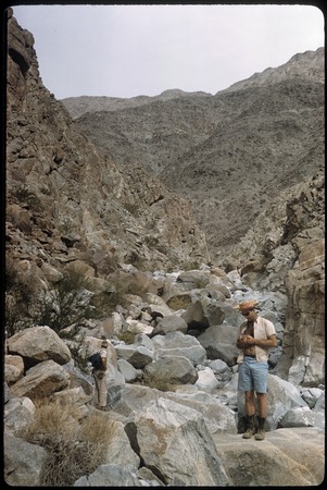
Bud Bernhard in 1961

David K - 12-6-2021 at 08:35 AM

Howard Gulick (Lower California Guidebook) photographed Bud in the Sierra Cucapá, on Feb 12, 1961:


Bud Bernhard 1961.jpg - 266kB

[Edited on 12-6-2021 by David K]

Barry A. - 12-6-2021 at 01:27 PM

Quote: Originally posted by David K  
Thanks for sharing the story Vince.

What would have happened to Bud's map, do you think? The map mentioned by Froy in his book (quoted by geoffff above).
Did he have children who may still have it?


I was alerted via e-mail this morning to this BAJA NOMAD "thread" (Canyons) by Dr. Vince Flynn of Coronado, a Coronado high-school classmate of mine and good friend. I knew Edward "Bud" Bernhard pretty well back in the '50's and '60's, and beyond, and went on several of his trips into Northern Baja. I believe I have a copy of the Map referred to by Geoff, and other's above. I also have a copy of the "Dec. 12,1963" freehand-map prepared by Bud Bernhard at the request of Al Schmitz of the Sierra Club dealing with that portion of the San Pedro Martir plateau and west-facing foot hills just west of Picacho del Diablo and east of Melings Ranch. It also deals with the some of the canyons and their names on the eastern slope of the San Pedro Martir just south of Picacho del Diablo and north of Matomi Canyon. I am not tech-savvy enough to include photos of the 2 maps, unfortunately, and I live in Redding, CA north of Sacramento. The 2 maps are laminated back-to-back in heavy duty pliable plastic (2' 4" X 1' 9") and are in excellent condition and have many interesting comments by Bud on both of them. I also knew "Myron Smith" casually, but unfortunately have no details about him that I can relate or remember other than he was a very interesting fellow Baja traveler back in the '60's.

David K - 12-6-2021 at 01:42 PM

Hi Barry, and it was me who alerted Vince, lol.
Can you scan the maps and email them to me? Otherwise, please email the photos and I will post them.
You are a Baja treasure!

Barry A. - 12-6-2021 at 02:32 PM

David---------I will get with my slightly more tech-savvy wife and see what we can come up with on photos of the maps and sending them to you. There is a LOT of small detail on the maps, so it may be hard to capture everything on a photo.

PaulW - 12-6-2021 at 02:37 PM

Barry, if you are using your phone use max resolution
Thanks.

David K - 12-6-2021 at 04:24 PM

Quote: Originally posted by Barry A.  
David---------I will get with my slightly more tech-savvy wife and see what we can come up with on photos of the maps and sending them to you. There is a LOT of small detail on the maps, so it may be hard to capture everything on a photo.


What ever I can do to help on this end, you have my assistance. If you don't have a scanner on your PC or have Copy shop in your village, then close-up photos may work, even if they are in parts. Geoffff, here on Nomad, is amazing at stitching together pieces of a map to make it whole again!

David

Bud's Maps from Barry A

David K - 12-6-2021 at 05:42 PM

Two images... posting here as I got them... but, I also sent them to geoffff, who is a wizard at improving map images, so stay tuned...


Edit: Scroll down to see better imagery...

[Edited on 12-7-2021 by David K]

Barry A. - 12-6-2021 at 06:08 PM

Yikes!!!!! Map pictures came out very fuzzy and hard to read. Sorry!! I will try again later-----like tomorrow. Need more light and a steady hand with the camera. B

David K - 12-6-2021 at 06:37 PM

No worries... but if you can get closer and take a photo of just a half then the other half of each map for better size resolution. Have a bright light on it if possible.
Thanks!

JZ - 12-6-2021 at 07:04 PM

Quote: Originally posted by Barry A.  
David---------I will get with my slightly more tech-savvy wife and see what we can come up with on photos of the maps and sending them to you. There is a LOT of small detail on the maps, so it may be hard to capture everything on a photo.


The easiest way to get a very high res copy would be to take them to a FedEx Office Print Center. They are all over.

They will be able to scan them for you. And will email them in PDF format. Then you can email to DK. Shouldn't cost more than a couple dollars.


[Edited on 12-7-2021 by JZ]

mtgoat666 - 12-6-2021 at 10:31 PM

Quote: Originally posted by JZ  
Quote: Originally posted by Barry A.  
David---------I will get with my slightly more tech-savvy wife and see what we can come up with on photos of the maps and sending them to you. There is a LOT of small detail on the maps, so it may be hard to capture everything on a photo.


The easiest way to get a very high res copy would be to take them to a FedEx Office Print Center. They are all over.

They will be able to scan them for you. And will email them in PDF format. Then you can email to DK. Shouldn't cost more than a couple dollars.


[Edited on 12-7-2021 by JZ]


Large-format scans cost more like $10 to $20 per sheet.

 Pages:  1