BajaNomad

Hwy 5 / Chapala Updates???

Pacifico - 10-4-2018 at 07:41 AM

Does anyone have any CURRENT info about Hwy 5? Some friends came south yesterday and said that Hwy 5 was closed at Chapala. It looks like there are some bypass roads already in place. Any updates are appreciated! My friends were some of the people that got trapped on an island (on the 5) and had to spend the night out there during the storm! Quite the Baja story!

StuckSucks - 10-4-2018 at 09:12 AM

HWY 5 bridge washout by Gonzaga

Sierra Faust - 10-4-2018 at 09:42 AM

We weathered the storm at Gonzaga Bay, and just made it out and back to San Diego on Wednesday. We had to go south from Gonzaga Bay to MX-1 and then north. The unpaved section of MX-5 is in great condition (only 17 miles left unpaved), and MX-1 is its usual self.

When we were pulling out on Wednesday morning, it was not recommended to try MX-5 north in our Subaru Outback.

Welcome to the forum!

AKgringo - 10-4-2018 at 10:18 AM

Quote: Originally posted by Sierra Faust  
We weathered the storm at Gonzaga Bay, and just made it out and back to San Diego on Wednesday. We had to go south from Gonzaga Bay to MX-1 and then north. The unpaved section of MX-5 is in great condition (only 17 miles left unpaved), and MX-1 is its usual self.

When we were pulling out on Wednesday morning, it was not recommended to try MX-5 north in our Subaru Outback.


Your first posts on this forum are very timely, and useful! Most first time posts are are looking for information (which is what this forum is all about!), but you started right off with a meaningful contribution!

Have you been following this website for a while? I look forward to reading more of your insights about Baja, if you care to share them.


Pacifico - 10-4-2018 at 07:58 PM

Thanks! Heading north tomorrow....sounds like I’ll be heading up the Pacific side!

billklaser - 10-4-2018 at 08:31 PM

Just went by 5 at Chapala today, have the road closed.

norte - 10-4-2018 at 09:35 PM

One of the other posts here says Chapala road is fine. they left Gonzaga that way yesterday to go north on 1.

JZ - 10-4-2018 at 10:06 PM

Quote: Originally posted by norte  
One of the other posts here says Chapala road is fine. they left Gonzaga that way yesterday to go north on 1.


Open going South, not North.


larryC - 10-5-2018 at 06:37 AM

I just came south yesterday on hwy1, hate that road but as I went by the hwy5 intersection at Chapala I saw signs that seemed to indicate that the road was closed, but I didn't stop and read them. You can probably stop today when you go by and see what the signs actually say. No problems on hwy1 except for Catavina the arroyos just north and south were washed so you have to go slow through there. Also they asr working on the road just south of Santo Tomas and you may get stuck there for a half hour or so as they have reduced it to one lane and the line of vehicles was a couple of miles long when I went through and the wait was about 30 minutes.

tuckles - 10-6-2018 at 12:38 PM

Has anyone traveled Hwy. 5 yesterday or today from San Felipe to Hwy. 1. If so, what types of vehicles can make the trip. How are all the detours? If you have traveled that route, Oct. 5 or 6 would you think it would be okay for a later model Ford Explorer 2-wheel drive? Thanks.

freediverbrian - 10-6-2018 at 01:46 PM

Heard from a friend in San Felipe that hwy 5 south bound out of San Felipe was closed and federales were tuning cars back . Up to a week

[Edited on 10-6-2018 by freediverbrian]

DouglasP - 10-7-2018 at 06:56 AM

https://m.facebook.com/groups/400767196648940/
I'm not a face book user, but you can view without joining.
The post is about 8 hours old, guys says he drove from San Felipe to Puertecitos. Two wheel drive truck, wouldn't advise a car or big trailers doing it.

[Edited on 10-7-2018 by DouglasP]

RFClark - 10-7-2018 at 10:55 AM

Hi,

Most of the problems on Hwy 5 are south of KM 40 to Gonzaga Bay. The word is that the road is closed from KM 75 To Gonzaga Bay. Last night the 1st 18 wheeler went by north bound probably from the fishing camps around KM 70.

The big problem seems to be the major bridge that is undermined near KM 100

We may drive down to where the road is closed today. I will post pictures and info if any is available.

There is the possibility of another storm the end of this week or not!

DouglasP - 10-7-2018 at 11:04 AM

Quote: Originally posted by RFClark  
Hi,

Most of the problems on Hwy 5 are south of KM 40 to Gonzaga Bay. The word is that the road is closed from KM 75 To Gonzaga Bay. Last night the 1st 18 wheeler went by north bound probably from the fishing camps around KM 70.

The big problem seems to be the major bridge that is undermined near KM 100

We may drive down to where the road is closed today. I will post pictures and info if any is available.

There is the possibility of another storm the end of this week or not!


RF, we are heading down to our place in Punta Chivato from Idaho. We are planning to be crossing the border Tuesday morning. Really wanting to take Hwy 5 down if possible. Really hoping to hear more definitive info by Tuesday AM. We have a high clearance 4x4, so some rough stuff would be okay. Please share any info you find out.

mtnpop - 10-7-2018 at 03:21 PM

Almost every site has Sergio coming across that area friday/sat this week... Looks like you might be that far before the storm if the road is open. We are planning late next week but now not sure. really did not want to go back to traveling down 1.
good luck

freediverbrian - 10-7-2018 at 04:51 PM

From face book cowpatty

IMG_1075.PNG - 143kB

DouglasP - 10-7-2018 at 07:43 PM

Well that report pretty much weld it. Down 1 we go! Beat feet and get in before Sergio hits.
Thanks for the report, heart goes out to those effected, that doesn't sound good. Be safe.

RFClark - 10-7-2018 at 10:35 PM

Hi,

We drove as far as the washed out bridge at KM 100 today. The road was passable that far south with lots of bypasses and lots of rocks and undermining south of KM 80 or so.

In my opinion the washout at KM 100 would be difficult even for 4x4s lots of very soft sand in the river bottom. There are a lot of places that look like things will get worse. (Cracks in the road and rock slides)

One of the wells at KM 60 seems to be destroyed. The other is still there with tracks leading in and out.

The road work between KM 60 and KM 75 is largely destroyed. Most of the culverts were too small by a factor of 3X. The road is passable on the bypass

The Pemex station at KM 76 (on the side road) was open and still had gas.

The dry lagoon south of KM 85 is no longer dry!

I have some pictures I’ll post from the States, we’re going back tomorrow.

DouglasP - 10-8-2018 at 05:47 AM

RF, thank you for the first hand report. No way we will be trying to head down Hwy 5 at this point. I hope I'm wrong, but it looks like Sergio is gonna try and finish what Rosa started.

BajaMama - 10-9-2018 at 07:13 AM

Well this is a bummer - was gonna head up Mex 5 for the first time end of October but with additional damage coming from Senior Sergio, I'm not confident it will be passable for my old lady SUV.

David K - 10-9-2018 at 07:21 AM

Just stay tuned and see how things are the day before your trip. In 2010, it was Highway 1 that had several bridges washed out.

Friday 10/12 - San Diego to Punta Bufeo

samhigh - 10-9-2018 at 01:29 PM

Nomad Crew,

Thanks for the updates in this thread. I am debating about my upcoming trip.

Leaving San Diego Friday, 10/12 in the early AM, trying to head all the way to Punta Bufeo before sun down. Return Sunday or Monday. Will be in a 2x4 toyota tundra.

Is it crazy to even try? The pictures of the 5 FWY collapsed / washed out has me feeling a little worried.

Some Alternatives:
Stay in San Felipe instead.
Stick to the Pacific coast, wait for the 5 FWY to be repaired

Any feedback greatly appreciated. Thanks!

vandenberg - 10-9-2018 at 01:34 PM

With that time frame, you better keep an close eye on Sergio.Looks like bad timing to me.

BajaDanD - 10-10-2018 at 02:54 AM

We drove through from San Felipe to Chapala on Saturday Oct 6th Starting from about 25k south of San Felipe the road is wasted every bridge every culvert is washed out and sections of road are just missing. Rock slides go for miles blocking the southbound lane. Everything from about 10k before Gonzaga to Chapala is the same as it has always been and didn't look like the storm did any damage.
It was definitely an adventure you can only find in Baja we had to make our own path at times there was so much road damage that some of the normal Baja bypasses had not been constructed yet at some of the washouts. It is passable but we needed 4x4 a few times.
All I can say is that it was sad but fun. Id say it won't be repaired for a few years

Cappy - 10-10-2018 at 05:29 AM

Road report from friends driving north La Paz to San Felipe.
“ Road is pretty messed up. Multiple crews cleaning up and forming bypass. 4 3\4 hours from turnoff at hwy 1 to San Felipe. 20 minute stop at Coccos ( all good) fuel available at Gonzaga . They where driving all wheel drive suburban pretty much stock. This report was as of Tuesday

David K - 10-10-2018 at 07:53 AM

Thanks!

BajaDanD - 10-10-2018 at 09:13 AM

We drove from San Felipe to Chapala on the 6th it was bad but not impossible starting from about 25 km South of San Felipe every bridge and culvert was washed out huge sections of road was missing we had to use 4 x 4 a lot. Some sections still have no bypass around. We followed tire tracks sometimes a 1/4 mile off to the side that eventually brought us back to the road longest detour was maybe 1/2 mile long
The section that runs through the lava fields had Boulders and rocks blocking the southbound lane for miles but passable
The road crews were at the southern most bridge washout working there way North. Some of the Boulders looked too big for the equipment they were using hopefully they get some bigger equipment in there
We are heading north from Cabo Pulmo tomorrow morning we will probably go back the same way. Baja, It's all about the adventure right
I'll give an update when I get home

BajaDanD - 10-10-2018 at 09:19 AM

Forgot to mention the look on the faces of the guys at the military checkpoint just north of Gonzaga when we drove up.
Priceless

samhigh - 10-10-2018 at 04:53 PM

Saw this on the Peurtocitos Happenings FB page today:

I crossed from Puertecitos to San Felipe again today. The road is much better. I think trucks could pull average trailers like 24'. I think cars can make it just watch out for a few rocks sticking up could put a hole in your oil pan. Took me 90 min at night in a truck. I dont think big motor homes can make it yet. there are a few washes still to steep/

Thanks Bryan for the update.

redhilltown - 10-10-2018 at 05:11 PM

Drove it Sunday north from Chapala to San Felipe. If careful it is quite doable. The bypass roads while not marked are certainly obvious. Only real stretch that is tough where you can lose the bypass roads is the mess near Huerfanito. If you see anyone ask them the best route. As someone said it is going to take years to get this sucker right again.

SuperScrappy - 10-11-2018 at 12:15 PM

Rosa Update to Mex 5 (10/10). Much better then when we came thru on 10/7. More heavy equipment and go arounds near all of the bridges that were out. No the road is not closed (reports were that it was. There was a sign on the Chapala end that had fallen down, but think it was more to detour the semi-trucks). I still would not recommend semi-trucks or RV's. But the road is very doable in trucks and cars with good clearance. I would NOT travel at night as there are several areas of payment that are cracked/fallen that are not marked well. There are surveyors out (I am sure trying to figure out where to place new bridges). There is no work going on the dirt road south of Gonzaga to Chapala. But it is in really good condition and completed that section in about 40 minutes. I posted a bunch of pictures on Talk Baja on FB

BajaDanD - 10-13-2018 at 12:58 AM

We left Guerrero Negro Friday morning around 7:30 arrived home in Prescott Arizona at 9:00pm. When we got to Chapala we sat there trying to decide between Hwy 1 or Hwy 5 it was raining and looked like the storm was right over the Hwy 5 route. Looking north on Hwy 1 while we sat there a rainbow appeared. I saw that as a sign to go the other way, east into the storm. It rained all the way to just before San Felipe.
We had come through there going south 5 days earlier we felt that it would be a better choice.
There were bypass routes around all the washouts and crews working to clear rocks
Baja ingenuity at it's finest

mtnpop - 10-20-2018 at 05:31 PM

Well, arrived in San Felipe this afternoon headed south. Have not seen or heard much news about 5 over to mex 1 for a few days so thought we might take the chance. Have had some conflicting reports but trying to get more info from locals.
Think we can probablly negotiate it with the raised H3 with really new tires etc. will take it slow and send post a report tomorrow evening if we get through. do not want to go back north and cross over to 1 at ensenada (sp)
Was shocked to see magna at 19.75 a litre and the good stuff at 21.20 but what will be. also two of the pemix stations in San Felipe arre now an Arco and a Chevron. did not see their posted price.
Will try to get pics on 5 but don't know if I can get them posted.
wish we had a couple of travelin buddies to tag along with but not yet..
happy trails....

Pacifico - 10-20-2018 at 09:56 PM

Quote: Originally posted by mtnpop  
Well, arrived in San Felipe this afternoon headed south. Have not seen or heard much news about 5 over to mex 1 for a few days so thought we might take the chance. Have had some conflicting reports but trying to get more info from locals.
Think we can probablly negotiate it with the raised H3 with really new tires etc. will take it slow and send post a report tomorrow evening if we get through. do not want to go back north and cross over to 1 at ensenada (sp)
Was shocked to see magna at 19.75 a litre and the good stuff at 21.20 but what will be. also two of the pemix stations in San Felipe arre now an Arco and a Chevron. did not see their posted price.
Will try to get pics on 5 but don't know if I can get them posted.
wish we had a couple of travelin buddies to tag along with but not yet..
happy trails....


You will be just fine in your H3... Good luck!

mtnpop - 10-21-2018 at 06:20 PM

Wow, those 2 storms made a mess of 5 north and south of Puertocitas.
bridges, culverts, roadway. it is passable and many 18 wheelers were using it, not sure how but there they were. would not recommend pulling any trailer or driving a big motorhome through this way for awhile.
We were on it on Sunday so no workers anywhere... lots of equipment still there but no live bodies..
mex 1 is pretty much pot hole gone now so it was a good drive south..
later

BajaMama - 10-31-2018 at 10:39 AM

I did indeed drive the five from Mex 1 to San Felipe. For those of you who have never driven this route before: DON'T follow the sign that indicates a right turn to Mexicali/San Felipe. You will end up at Coco's Corner. Then you back track 4 miles to another road in which you will question your sanity for doing alone (I did not pass ONE other vehicle) and wondering "why does everyone say trucks can take this road" because you know there in no way in h - e - double hockey sticks a semi can negotiate those steep big rocks.

So fellow nomads, where did I make the wrong turn? Was it at the sign or before that? BTW I was heading north.

BajaMama - 10-31-2018 at 11:01 AM

Okay, now I'm looking at Google Maps, and it indicates that Mex 5 goes right past Coco's. Is that right, and did I listen to a local gentleman who purposely steered me in the wrong direction? (at Coco's I asked if I was on the correct road and he said no and told me to go the way I did...)

[Edited on 10-31-2018 by BajaMama]

David K - 10-31-2018 at 05:53 PM


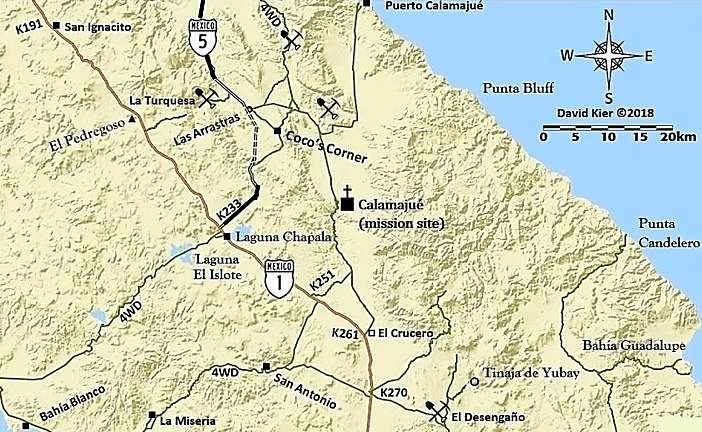
Coco's Corner has been on the main road between Chapala and Gonzaga since the 1990s.
The new highway route bypasses Coco's to the west (see my dashed lines for that part. The north end is at Las Arrastras) but it is not completed and there is a rough almost 1-mile detour to get to it and avoid Coco's or to see the newer road.
In the meantime, all traffic should just continue to go by Coco's.

I gave great detail of this with satellite maps in my August 2018 trip report (TRIP #8).

BajaMama - 11-1-2018 at 06:37 AM

Thanks David, looks like I should not have listened to the gentleman who guided me back four miles and just kept going forward past Cocos. Unfortunately I thought I read on a recent BN post that if you ended up at Cocos you made a wrong turn somewhere... Oh well, live and learn! It was an adventure. Next time I will make sure I am in my husband's 2006 Ford F250 diesel 4x4!

David K - 11-1-2018 at 10:38 AM

You have researched this trip so heavily, too. Oh well, now you know. Please feel welcome to print any of my maps to take with you.

PaulW - 11-2-2018 at 05:44 AM

Go around the damaged road looks pretty decent.
FYI
https://facebook.com/Kentgharrington/videos/1021527696401074...

Ron in BC - 11-3-2018 at 04:27 PM

Great clip, thanks

Cancamo - 11-6-2018 at 11:57 AM

Went through 11/1, piece of cake.
One spot on bridge diversion where 18 wheeler was stuck going up hill as road was real loose from previous trucks, just go around. As usual drop down tires to around 18/20 lbs. between Gonzaga and Chapala, fill up at llantera at other end in Chapala.
All the iron in the mountains was parked, almost nobody around, according to fella in llantera, they ran out of money.

Hwy 5

rimrock - 11-11-2018 at 05:24 AM

Any recent reports on Hwy 5 ? Heading south on the 18th and trying to decide our route. 30' 5th wheel with 4x4 truck. Have done it the last 4 years in a 35' Class A motorhome with no concerns. Figure if semi's are using it I should be fine albeit slow. Any thoughts appreciated.

MICK - 11-11-2018 at 07:31 AM

I drove it last week. Not sure I would tow a fifth wheel due to the detours. The rest of the road is ok but that one detour where the truck is stopped, and has been for at least a week is a steep up hill. I did see a tow behind that had gone up that hill. Just not sure for me it would be worth it if I had the time to go around.
Mick

hermosok123 - 11-11-2018 at 10:41 AM

Just returned from Gonzaga. I would not want to try to navigate the race traffic along with the Semis. Some of the detour switchbacks are one vehicle only so you have to wait your turn and if you miscalculate or do not see the tractor trailer rig over the rise you would have to back up. Use Hwy 1 with that trailer. The off road portions of 5 will beat the snot out of your trailer and its contents. 3 plus hours towing a small utility trailer with a 4X4 truck, Rancho Grande to SF.

Another view

John M - 11-11-2018 at 04:27 PM

We drove Chapala through Coco's to San Felipe on the 9th.

The road nearest Highway 1 is really nice shape compared to earlier trips. There is then a little rough surface for a couple of miles but soon you are onto the new roadbed - we somehow missed the route that bypasses Coco's and so we had two or three miles of the old rocky slow section - the only really slow part. After Coco's the main road is the smoothest I remember it, no need to take those sandy side roads. Then, it's onto the gravel base of the new road, mixed with new blacktop and you are off to the races.

North of Rancho Grande we thought that all the detours - maybe a dozen of them were just fine. smooth gravel, and mostly less than 300 yards long each. North of Puertecitos there is nine miles of good gravel where they are making a new road - it was smooth, easy going. From KM 60 to KM 40 there are the usual potholes.

Narrow? in a couple of places but I don't think it was anything to be concerned about. There is good visibility of oncoming traffic.

Encountered a military checkpoint at KM 10.

Though I was in my Tacoma, I don't think a motorhome or other RV should have issues if you exercise reasonable care.

John M

Thanks!

rimrock - 11-12-2018 at 08:14 AM

Thanks for the replies. Will post an update of my experience, figure I have more of a comfort margin with my 4x4 and increased clearance margin on my 5th wheel vs my class A. I go 10mph and enjoy the scenery, still much preferred for me over the chaos of Hwy 1.

BajaZephyr - 11-12-2018 at 01:38 PM

Well, everyone that’s saying it’s easy is clearly not in an RV. We just attempted it south with our 4X4 truck towing a lightweight 19-ft trailer. As the previous post mentioned, Km 40-60 has several washed out sections that have been filled with gravel, but you still have to significantly slow down for them. At Km 60 we hit the new construction gravel and could only go 10 km/hr without rattling overselves. We have done the 35-km section past Coco’s many times and were prepared for that, but not for several more miles of gravel before even hitting Puertocitas. Someone going the other way told us it was 40 km of gravel so we turned around.

David K - 11-12-2018 at 05:35 PM

My trip report here on Nomad for August 2018, detailed the kilometer markers and distances for all the unpaved and detour routes. The flash flood damage happened on or around October 1 and it has added many more, but short, detours around washed out bridges and roadbeds.