BajaNomad

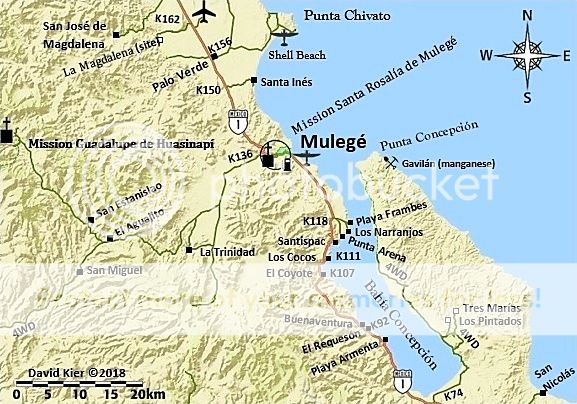
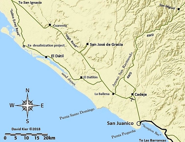
Mulege to San Juanico and back, quick rip.

DouglasP - 11-3-2018 at 06:24 AM

This is just a test to see if this file works. This should open in Google earth. Going to put a little trip report together a bit later.

Attachment: San Juanico to Mulege.kml (118kB)
This file has been downloaded 487 times

DouglasP - 11-3-2018 at 06:46 AM

I see the file has been downloaded a few times, anyone able to open it?

C205Driver - 11-3-2018 at 07:40 AM

Yes, no issues on an iMac.....

BajaMama - 11-3-2018 at 07:41 AM

I'm getting an interactive map ?

MontyF - 11-3-2018 at 07:41 AM

yes, the download opened showing a bunch of waypoints starting at Rancho Estanislao

AKgringo - 11-3-2018 at 07:42 AM

I was not able to view it using Windows media player. I did not want to "shop for an app" in the store.

4x4abc - 11-3-2018 at 08:13 AM

opens with 4 errors
shows with an empty folder in Google Earth Pro
and it shows one track
somebody butchered the file(s)


55steve - 11-3-2018 at 08:20 AM

Worked perfect for me.

DouglasP - 11-3-2018 at 08:49 AM

Thanks for the feedback, works for some not for others. It's a file I exported from backcountry navigator. Heres a screen shot. It was a fun trip, I will post some pics shortly.


Screenshot-20181103-093503.jpg - 79kB

Maybe....struggling with this on my new whiz-bang tablet :fire:

DouglasP - 11-3-2018 at 09:01 AM


[Edited on 11-3-2018 by DouglasP]

David K - 11-3-2018 at 09:15 AM

Thanks DouglasP for trying!
I was not able to see the track on Google Earth Pro (Windows) but will try again.

[Edited on 11-3-2018 by David K]

DouglasP - 11-3-2018 at 09:24 AM

Weird, because when I click on the link and download it it ask me what I want to open it with and it gives me Google Earth as an option.

David K - 11-3-2018 at 09:30 AM

Quote: Originally posted by DouglasP  
Weird, because when I click on the link and download it it ask me what I want to open it with and it gives me Google Earth as an option.


It might be on my end because my Google Earth is the one with the El Camino Real waypoints. I just didn't see any track line for your trip, but I have for others on it? I can try by opening up a fresh Google Earth file. I was on part of the road, to get to Mission Guadalupe, last year. Very pretty country up there!


[Edited on 11-3-2018 by David K]

TMW - 11-3-2018 at 09:31 AM

I didn't have any problems with it.

TMW - 11-3-2018 at 09:34 AM

David it is a red line on my screen.

David K - 11-3-2018 at 09:39 AM

Thanks Tom... I would see something even with my color-blindness, but just not know if it was red or green. It would be hard for me to see if the background was a similar color. That is why I appreciate you making track lines yellow or blue or white... I see those bright colors quite well, just reds and greens are difficult for me.

DouglasP - 11-3-2018 at 09:39 AM

Oh well, here's the story on the trip. We just purchased a home in Punta Chivato. We made a trip down to bring some furnishings and get the house ready for us. I couldn't handle it any longer and talked my wife into making a trip across the peninsula and back. It was just a quick turnaround over one day spend the night and back the next. Our first of many trips I hope.


Lots of green desert, water crossings, goats wanting beer, road side tail gate picnics, tail pipes that don't want to stay put, boats that Sergio his way with, roads that weren't and more green, green desert.

OI000254.jpg - 61kB OI000264.jpg - 128kB OI000323.jpg - 95kB OI000331.jpg - 114kB


OI000333.jpg - 98kB OI000337.jpg - 119kB

David K - 11-3-2018 at 09:40 AM

GREAT! Is that San Miguel in the last image? Did you see the cemetery there? It was built on top of the mission visita church.

DouglasP - 11-3-2018 at 09:41 AM


OI000344.jpg - 119kB OI000352.jpg - 89kB OI000361.jpg - 98kB OI000370.jpg - 106kB OI000393.jpg - 70kB OI000402.jpg - 56kB

DouglasP - 11-3-2018 at 09:44 AM


OI000274.jpg - 99kB OI000282.jpg - 69kB OI000285.jpg - 109kB OI000286.jpg - 107kB OI000287.jpg - 119kB OI000411.jpg - 148kB OI000414.jpg - 100kB OI000416.jpg - 100kB

DouglasP - 11-3-2018 at 09:46 AM


OI000298.jpg - 72kB OI000297.jpg - 73kB OI000299.jpg - 97kB OI000426.jpg - 141kB Screenshot-20181103-102010.jpg - 101kB

DouglasP - 11-3-2018 at 09:51 AM

This last image shows an old satellite image of where the road used to be and then the track of where we actually had to go. Which the pictures where the truck is sitting on the slab.

David K - 11-3-2018 at 10:07 AM

Sweet! Good truck!!

4x4abc - 11-3-2018 at 10:08 AM

Quote: Originally posted by David K  
Thanks Tom... I would see something even with my color-blindness, but just not know if it was red or green. It would be hard for me to see if the background was a similar color. That is why I appreciate you making track lines yellow or blue or white... I see those bright colors quite well, just reds and greens are difficult for me.


I usually change track colors of tracks that I download (I don't like the preset Google colors)
highlight the track you wish to change
hit Command - I
select "Style, Color"
pick any color you like and select any line thickness you like

David K - 11-3-2018 at 10:17 AM

Thanks Harald!

DouglasP - 11-3-2018 at 10:53 AM

Here's a shot of the non road detour. I circled the Mexican road signs (arrows on rocks).

OI000411_1.jpg - 181kB

JZ - 11-3-2018 at 11:47 AM

Loads perfectly in both Google Earth and Back Country Navigator on my phone.

Also loads fine on Windows.

On your PC you can change the color and weight of any track in GE.


[Edited on 11-3-2018 by JZ]

gueribo - 11-3-2018 at 12:13 PM

Thanks, DouglasP, for the photos, the map, and the report. So much to see in that area. I've done that road from Mulege, but headed northwest to the Mission Guadalupe ruins, on to San Jose de Magdalena and back to Hwy 1, when the whole loop was possible to drive. Some of the most beautiful scenery I've seen in Baja (which is saying a lot!) . . . twisting canyons and ghostly white wild fig . . . photos can't even do it justice.

Meany - 11-4-2018 at 07:57 AM

Hola DouglasP and TWFP. Boy what a fun trip for your first across Baja. That is a fun road and the land is beautiful. Glad to see the NEW Toyota worked well for you. I'm like gueribo, I like the Mission Guadalupe and the area around it. Go next time in your can-am and camp out there. MUCHOOO Fun. Meany

DouglasP - 11-4-2018 at 07:58 AM

Quote: Originally posted by David K  
GREAT! Is that San Miguel in the last image? Did you see the cemetery there? It was built on top of the mission visita church.


David, I'm not sure, I really don't know many of the land marks and sites yet. The camera I took the picture with has GPS coordinates logged for each picture, I'll check. I'm hoping you guys will chime in and point things out you may recognize and point me towards some sites we missed. Being it was our first outing, we were focused on getting to San Juanico and seeing what would could along the way.
Thanks for the compliment on the truck. :)

DouglasP - 11-4-2018 at 08:08 AM

Quote: Originally posted by gueribo  
Thanks, DouglasP, for the photos, the map, and the report. So much to see in that area. I've done that road from Mulege, but headed northwest to the Mission Guadalupe ruins, on to San Jose de Magdalena and back to Hwy 1, when the whole loop was possible to drive. Some of the most beautiful scenery I've seen in Baja (which is saying a lot!) . . . twisting canyons and ghostly white wild fig . . . photos can't even do it justice.


We will definitely head up to Guadalupe, thanks for the tip. "Ghostly white wild fig", do tell. Haven't heard this before.

DouglasP - 11-4-2018 at 08:16 AM

Quote: Originally posted by Meany  
Hola DouglasP and TWFP. Boy what a fun trip for your first across Baja. That is a fun road and the land is beautiful. Glad to see the NEW Toyota worked well for you. I'm like gueribo, I like the Mission Guadalupe and the area around it. Go next time in your can-am and camp out there. MUCHOOO Fun. Meany


Hey Steve, yeah it was awesome. Truck did great, couple tweaks yet to do. One of the more interesting spots was the return trip. We turned off the paved road south of San Juanico and came into the washed out area. I'm curious how long it's been that way or was it a recent wash out? The satellite image is old.

Loving the house, getting to know some of the neighbors, too. Nice folks.

DouglasP - 11-4-2018 at 08:18 AM

Quote: Originally posted by JZ  
Loads perfectly in both Google Earth and Back Country Navigator on my phone.

Also loads fine on Windows.

On your PC you can change the color and weight of any track in GE.


[Edited on 11-3-2018 by JZ]


Hey JZ, when you say loads fine on Windows, what program are you using?

[Edited on 11-4-2018 by DouglasP]

gueribo - 11-4-2018 at 08:56 AM

Ghostly white wild fig!

fig1.JPG - 229kB

DouglasP - 11-4-2018 at 09:44 AM

Cool, we will be on the look out!

JZ - 11-4-2018 at 11:48 AM

Lots of water and looks like a pretty rough road.

David K - 11-4-2018 at 12:07 PM

Quote: Originally posted by DouglasP  
Quote: Originally posted by gueribo  
Thanks, DouglasP, for the photos, the map, and the report. So much to see in that area. I've done that road from Mulege, but headed northwest to the Mission Guadalupe ruins, on to San Jose de Magdalena and back to Hwy 1, when the whole loop was possible to drive. Some of the most beautiful scenery I've seen in Baja (which is saying a lot!) . . . twisting canyons and ghostly white wild fig . . . photos can't even do it justice.


We will definitely head up to Guadalupe, thanks for the tip. "Ghostly white wild fig", do tell. Haven't heard this before.


I visited the Guadalupe mission site last year. It is extensive and not easy to find where the church itself was located. It is also surrounded by a barb wire fence to keep animals out. My photos and details are on Day 12 of my Trip #6 report: http://forums.bajanomad.com/viewthread.php?tid=87323
I included my 2017 photo in the latest printing of my book along with photos taken up to 20 years ago by Max Kurillo and Ed Vernon.