BajaNomad

Rockman trail

advrider - 12-17-2018 at 03:17 PM

Has anyone ridden the Rockman trail from Catavina over to highway 5 sense the big storms? I haven't ridden this trail before but I have the tracks but looking at it on google earth there is a large wash that you ride for a good distance out to the highway. I'm wondering if it is still doable or blown out? We are looking at hitting it in March on our way back south.

David K - 12-17-2018 at 04:11 PM

The Bill Nichols Rock Trail: From just south of Puertecitos to north of El Mármol. with connecting trails west and south that stay off paved roads.

We in 4WD vehicles have been seeking our own route between Hwy. 1 and Hwy. 5 for years.
TW, BillB, The squarecirle, CorkyB, and others... Arroyo El Volcán was an early hope, but boulders and waterfalls soon dashed that route (shown on the 1905 mining map as a trail).

The closest was La Turquesa Canyon, a road made by Fred Hampe of Rancho Santa Ynez, maybe following the abandonment of the road beyond Mission Santa María, he built in the 50s and 60s. The squarecircle is the first Nomad documented to have gotten through (with TW's help) the overgrown and abandoned road.

advrider - 12-17-2018 at 04:47 PM

Thanks, I see some youtube videos posted from this year of guys on moto's running it, even one guy last year on a 690 that ran it from East to West? Anyone else have any updated information? Thanks

From Baja Lou: The Bill Nichols Rock Trail Map

David K - 12-17-2018 at 05:19 PM

Hwy. 5 end and the Hwy. 1 end:

Bill Nichols-1.jpg - 173kB


Bill Nichols-2.jpg - 91kB

TMW - 12-17-2018 at 06:16 PM

Ask Tim Morton. He has ridden it in the past and may know someone who has ridden it lately if he hasn't. His web site is below.

https://www.bajaboundmoto.com/

advrider - 12-17-2018 at 06:23 PM

Quote: Originally posted by TMW  
Ask Tim Morton. He has ridden it in the past and may know someone who has ridden it lately if he hasn't. His web site is below.

https://www.bajaboundmoto.com/


Thanks, I will send him an email. I know he has ton's of Baja connections...

ehall - 12-17-2018 at 06:41 PM

I wouldn't be concerned with the wash. It is 1/4 mile wide soft sand. The short trail out of the wash might be interesting.

rich t - 12-17-2018 at 07:10 PM

I was also thinking about doing the Rockman trail in March from Puerticitos to El Rosario, then the 22 day trail to Catavina and L.A. Bay, we will be riding March 16-21, also going to do the Window Rock and Jimmy Shone trail

advrider - 12-17-2018 at 07:26 PM

I think we will just miss each other again! We are starting on the 3rd and will finish on the 15th or 16th? We will be running the cactus trail, window rock, 22 day and some other stuff we have been looking at. Hope to do rockman over to Puerticitos?

JZ - 12-17-2018 at 07:31 PM

Send me the tracks and I'll post some Google Earth screen shots.

I'd be interested to do this with you.

advrider - 12-17-2018 at 07:53 PM

Will do, it looks rocky but doable. I've found several videos showing sections of the trail. It would be nice to run the 22 day trail from BOLA to Catavina and not have to go all the way around to get back to SF!

JZ - 12-17-2018 at 08:05 PM

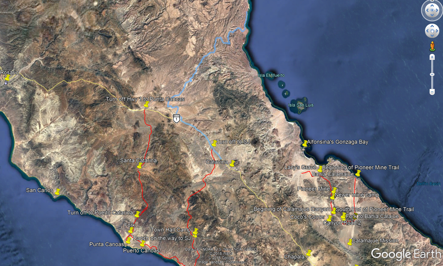
Rockman Trail in Blue.


4x4abc - 12-17-2018 at 08:17 PM

30% of the population is color blind
what blue line?
please make them white in the future
or attach the file

JZ - 12-17-2018 at 08:35 PM

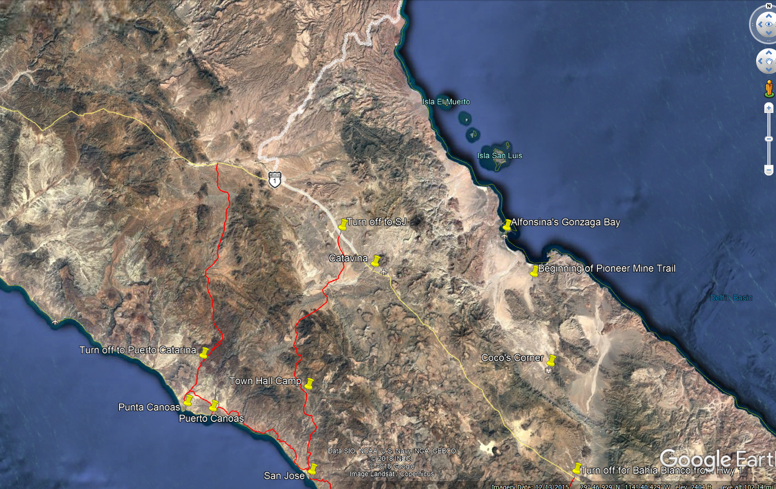
In white.


WestyWanderer - 12-17-2018 at 09:23 PM

adv, I rode the wash two weeks ago from HWY 5 toward Catavina to the base of the steep climb out of the canyon, the wash was super sandy but fun riding, nothing to be worried about at all. The storm actually made it better, flattened out all the woops

[Edited on 12-18-2018 by WestyWanderer]

PaulW - 12-17-2018 at 09:50 PM

Quote: Originally posted by JZ  
Rockman Trail in Blue.
==== =
Can you post a gps track please?

JZ - 12-17-2018 at 10:10 PM

Quote: Originally posted by PaulW  


Can you post a gps track please?


[Edited on 12-18-2018 by JZ]

Attachment: Rockman Trail.kmz (4kB)
This file has been downloaded 412 times


rich t - 12-17-2018 at 10:17 PM

Quote: Originally posted by advrider  
I think we will just miss each other again! We are starting on the 3rd and will finish on the 15th or 16th? We will be running the cactus trail, window rock, 22 day and some other stuff we have been looking at. Hope to do rockman over to Puerticitos?


Which trail is the cactus trail?

rich t - 12-17-2018 at 10:20 PM

Quote: Originally posted by JZ  
Quote: Originally posted by PaulW  


Can you post a gps track please?


Paul, from what I have been told we can do about the first 15 miles in the Jeeps, it starts at the Los Hemes wash about 10 miles south of Puerticitos.


[Edited on 12-18-2018 by JZ]

PaulW - 12-17-2018 at 10:47 PM

Thanks JZ
That track is low fidelity with very few breadcrumbs/track points, but I picked off the ends:
Hwy5 30 16, -114 39.4, Hwy1 29 54.9, -114 56.5
Fairly close except for the big bridge at Hwy5 requiring adjustment.
Putting that track on my to do list.
Forgive me my Almanac is in San Felipe and I am in Colorado. Web maps do not show Los Hemes.

JZ - 12-17-2018 at 10:50 PM

Quote: Originally posted by PaulW  
Thanks JZ
That track is low fidelity with very few breadcrumbs/track points, but I picked off the ends:
Hwy5 30 16, -114 39.4, Hwy1 29 54.9, -114 56.5
Fairly close except for the big bridge at Hwy5 requiring adjustment.
Putting that track on my to do list.
Forgive me my Almanac is in San Felipe and I am in Colorado. Web maps do not show Los Hemes.


This one might have more details.


Attachment: Rockman.gpx (28kB)
This file has been downloaded 360 times


advrider - 12-18-2018 at 07:32 AM

Quote: Originally posted by rich t  
Quote: Originally posted by advrider  
I think we will just miss each other again! We are starting on the 3rd and will finish on the 15th or 16th? We will be running the cactus trail, window rock, 22 day and some other stuff we have been looking at. Hope to do rockman over to Puerticitos?


Which trail is the cactus trail?


I think it's the track I got from you that was called the 22 day trail, but is what most called the cactus trail, the one that goes over the mud hills. I now have a track that is labeled the 22 day
trail but is different then the original I got from you, it goes from BOLA to Catavina.


Westy, thanks for the info, that's what I was looking for. Tim Mortin said the same thing, the whoops should be gone!

[Edited on 12-18-2018 by advrider]

February

ztrab - 12-18-2018 at 07:50 AM

I’ll be leading a group of 8 riders on my annual Jim Clark Memorial ride Feb 15th-25th. I’ll let you know trail conditions we encounter.

ehall - 12-18-2018 at 08:10 AM

Quote: Originally posted by advrider  
Quote: Originally posted by rich t  
Quote: Originally posted by advrider  
I think we will just miss each other again! We are starting on the 3rd and will finish on the 15th or 16th? We will be running the cactus trail, window rock, 22 day and some other stuff we have been looking at. Hope to do rockman over to Puerticitos?


Which trail is the cactus trail?


I think it's the track I got from you that was called the 22 day trail, but is what most called the cactus trail, the one that goes over the mud hills. I now have a track that is labeled the 22 day
trail but is different then the original I got from you, it goes from BOLA to Catavina.


Westy, thanks for the info, that's what I was looking for. Tim Mortin said the same thing, the whoops should be gone!

[Edited on 12-18-2018 by advrider]


22 day east is Bola to Hwy 1 6 miles south of Bola turnoff. 22 day west goes west from hwy 1 to Pacific. Comes out about 20 or so miles north of santa rosallillita

February

ztrab - 12-18-2018 at 08:12 AM

I’ll be leading a group of 8 riders on my annual Jim Clark Memorial ride Feb 15th-25th. I’ll let you know trail conditions we encounter.

David K - 12-18-2018 at 08:53 AM

Quote: Originally posted by 4x4abc  
30% of the population is color blind
what blue line?
please make them white in the future
or attach the file


Most of us color blind guys see blue and yellow easily, you have a really rare kind Harald. It is red and green I have a hard time seeing or telling apart. Women are rarely afflicted with this but they pass it down to their male children from the woman's father.
It is hard to explain our vision to normal folks... We see colors, but shades of red and green when mixed with other colors, like Google Earth map is like it being camo. to us. We also can't always tell purple apart from shades of blue since purple is blue and red mixed.

rich t - 12-18-2018 at 09:54 AM

Quote: Originally posted by ztrab  
I’ll be leading a group of 8 riders on my annual Jim Clark Memorial ride Feb 15th-25th. I’ll let you know trail conditions we encounter.


Can you send me the 22 day trail that you have, Cameron Steele told me that part of what I sent you by passes a pretty gnarly part of the 22 day trail.

rich t - 12-18-2018 at 09:59 AM

The above question was for ADVRIDER, I hit the wrong quote button

rich t - 12-18-2018 at 10:05 AM

Quote: Originally posted by PaulW  
Thanks JZ
That track is low fidelity with very few breadcrumbs/track points, but I picked off the ends:
Hwy5 30 16, -114 39.4, Hwy1 29 54.9, -114 56.5
Fairly close except for the big bridge at Hwy5 requiring adjustment.
Putting that track on my to do list.
Forgive me my Almanac is in San Felipe and I am in Colorado. Web maps do not show Los Hemes.


Paul, after about 15 miles west of Puerticitos the trail is a single track, we can pre run the first part in Jan. I have done a portion of it from El Rosario heading east, but to go all the way is for Motos only.

advrider - 12-18-2018 at 10:29 AM

Rich, just sent you a few tracks that I have that were labeled 22 day trail, let me know if someone can confirm what trail is what? If anyone has tracks for the camper shell trail, I would love to get them. Thanks

[Edited on 12-18-2018 by advrider]

bajaric - 12-18-2018 at 12:12 PM

As WW said, a lot of sediment was washed out of the mountains in the recent floods. Where the narrow canyons open up and the sediment dropped out any roads, whoops, or pits in the flood plain were obliterated and are now flat expanses of sand and gravel, sort of like fresh powder for motos. Fun!

advrider - 12-18-2018 at 06:49 PM

Just the news I was looking for, thanks for all of the input from everyone.... Still looking for camper shell tracks...

ehall - 12-18-2018 at 07:02 PM

Quote: Originally posted by advrider  
Just the news I was looking for, thanks for all of the input from everyone.... Still looking for camper shell tracks...


PM me your email and I will send it.

advrider - 12-18-2018 at 07:46 PM

Quote: Originally posted by ehall  
Quote: Originally posted by advrider  
Just the news I was looking for, thanks for all of the input from everyone.... Still looking for camper shell tracks...


PM me your email and I will send it.


Will do, and Rich you should have several track I sent that will helps us get all of the trails names straight!

mjs - 12-19-2018 at 09:27 AM

Friends rode Rockman and camper shell two days ago. It's fine, hard as usual.

advrider - 12-19-2018 at 08:18 PM

mjs, thanks for the info, looks like we should be good for March...

TFelix713 - 12-20-2018 at 09:40 PM

Had a few buddies ride Rock Man 4 days ago. Said it was as tough as ever.

ehall - 12-22-2018 at 11:32 AM

https://www.youtube.com/watch?v=ohhcUUKQ-T8 Youtube video of 22 day trail