
hombre66 - 1-4-2019 at 01:41 PM
Wife wants to birdwatch up at LH. Road condition? We now only have a 2wd Tundra. Looks like a late March trip for us. We also pull a really smal
tent trailer. 'preciate info from recent visitors.
Maderita - 1-4-2019 at 04:17 PM
Hola hombre66,
Which way are you driving, from Highway 3 near Ojos Negros, or south from Highway 2 at La Rumorosa?
The route from Hwy 3/Ojos Negros is has fewer miles of dirt road. It should be passable with 2WD in all but the worst winter storms and spring rains.
The route from Highway 2/La Rumorosa sees less traffic. Particularly south of KM35 (kilometer marker on the dirt road) to Laguna Hanson. It should
also be 2WD by late March. If there are unusually heavy rains in the previous week or two, there could be some big mud puddles which can get slippery
and difficult in 2WD. In that case, it would be best to take the road up from Hwy 3.
Old-timers might recall a steep narrow rocky section at KM38 south of La Rumorosa. That has been improved in recent years, widened, and a concrete
surface added. I tow a 4-horse trailer through that section with deliberate visual/mental calculations. 3 or 4 culverts have also been added to
prevent washouts between Hwy 2 and KM38.
Keep in mind that the mountains are 5,000' to 6,000' elevation. I've seen a snowstorm dump a foot of snow there in mid-May! So, late March is
"usually" okay to drive in 2WD. Expect your nights to be chilly, perhaps in the 30's F.
The road from Highway 2 is sometimes graded, well after the last spring rains. Expect lots of small potholes and small washboard - speeds of 20-25
mph, slowing now and then to 10 mph. A lovely scenic drive, don't let me scare you.
Rancho El Topo, a working cattle ranch, welcomes visitors. It's only 2 or 3 miles west from the main Laguna Hanson road; there is a big sign a couple
hundred yards past the KM 35 sign. Nice safe/secure camping under the pines. Horseback riding is available at a reasonable price. The Sandovals are
wonderful hosts, eager to please. Ricardo is fluent in English.
I drive hwy 2 to KM35 (Rancho El Topo turnoff) twice per month, so you might want an update on conditions a week before your trip.
David K - 1-4-2019 at 04:22 PM
See my Trip Report #8 (August 2018): http://forums.bajanomad.com/viewthread.php?tid=91029
In short, I think a 2WD Tundra (with good tires) will be fine. The exception would be with snow or a lot of rain. Next Baja truck please get one with
4WD, however!
0.0 Miles Hwy. 3 at Km. 54.5 (from Ensenada).
2.7 Fork, go left
3.8 Fork, go right
4.8 Oak Grove
5.2 Fork, go left (elev. 4,000')
11.2 First pine trees (elev. 5,000')
13.7 Rancho El Rayo
15.1 Road right to Rancho La Botella, cattle guard crossing.
16.2 Aserradero (abandoned homes) a former sawmill, elev. 5,277'.
16.4 Food advertised.
17.5 Cabins for rent, food store "Oxxxo".
19.1 Fork, go left.
19.8 LAGUNA HANSON (cabins) 68 pesos camping fee, elev. 5,300'
20.5 Km. 60 sign (37.2 miles from La Rumorosa, Hwy. 2).
22.1 Road east to Rancho San Luis... located above the top of Guadalupe Canyon.
23.8 Km. 55 sign.
24.6 Rancho Rodeo del Rey, an abandoned/ deteriorated hotel/restaurant.
25.0 Rancho Bajío Largo road west.
26.9 Km. 50 sign.
35.6 Rancho El Topo road west.
35.7 Km. 35 sign.
40.4 Former mining area of La Milla.
41.4 Condor road west, elev. 4,916'.
41.9 Km. 25 sign.
42.7 Junction with a road southwest from Las Margaritas.
44.4 Road to the east.
45.6 Rancho La Ponderosa road east.
47.2 Km. 17 sign.
48.7 Rancho Nuevo road east
53.1 Km. 7, 'Inspection' station, open gate.
55.1 Blacktop paved road begins.
55.4 Parques Los Potrillos and El Tesoro campgrounds.
57.5 Highway 2 (Km. 72), La Rumorosa.
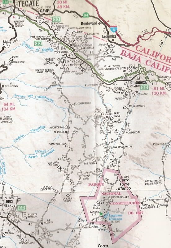
Here is the 2010 AAA map for a visual of the road location:
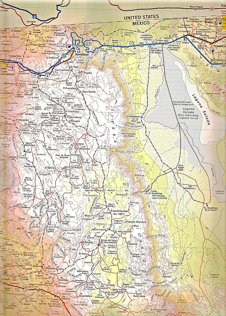
The 2009 Baja Almanac of the Sierra Juarez area:
[Edited on 1-4-2019 by David K]
hombre66 - 1-5-2019 at 11:27 PM
Thanks Maderita and DK. Lots to ponder.

