BajaNomad

Some pics form Puerto Los Gatos

JZ - 4-19-2019 at 12:24 PM

About 3 miles North of Timbabichi. Thanks to TMW for his trip reports inspiring us to go and check it out.


Drive in.


[Edited on 4-21-2019 by JZ]

John Harper - 4-19-2019 at 03:19 PM

Wow, spectacular. Were those drone shots?

John

4x4abc - 4-19-2019 at 03:35 PM

Cool!

Mulege Canuck - 4-19-2019 at 03:45 PM

Loved it there. My wife thinks it is the most beautiful place in Baja so far for us. The locals told me I was the first large truck camper in there. Not sure if that is true.

Did you meet the local security guy, Manuel?

Great pictures.

4x4abc - 4-19-2019 at 07:29 PM

Arroyo Puerto Gato is absolutely stunning (about 1.5 miles in from the beach)

North from Puerto Gato are a number of missionary time ranchos

Pacifico - 4-19-2019 at 07:59 PM

Great pics!

Satter - 4-20-2019 at 06:20 AM

Now I'm bummed out I didn't visit Puerto Gato when I had the chance. Next time I won't be making that mistake. Those pics are stunning.

gueribo - 4-20-2019 at 07:17 AM

So beautiful. Baja never ceases to amaze.

StuckSucks - 4-20-2019 at 08:33 AM

Quote: Originally posted by JZ  
About 3 miles North of Timbabichi.


Inspiring photos, thanks for sharing! One more place for my Bucket List.

fishbuck - 4-20-2019 at 09:04 AM

Is this a "secret" beach JZ?:cool:
The Sea Ray will be dropping the hook here soon.

4x4abc - 4-20-2019 at 09:45 AM

Quote: Originally posted by fishbuck  
Is this a "secret" beach JZ?:cool:
The Sea Ray will be dropping the hook here soon.


Puerto Los Gatos is on every map
Here for the modern world:
25°18'9.07"N, 110°56'44.09"W

JZ - 4-20-2019 at 10:01 AM

Quote: Originally posted by fishbuck  
Is this a "secret" beach JZ?:cool:
The Sea Ray will be dropping the hook here soon.


It was actually pretty crowded. I was thinking we'd have the place to ourselves.

There were 3 sail boats at anchor. And 3 pangas that were taking a large group up from La Paz to Loreto. They had maybe six tents. Plus a guy and his girl on the other end of the beach.

Leaving we passed about 3 or 4 gringo trucks coming in.

Took my boat there once and there was no one, so guess it was just because of Easter break.

[Edited on 4-20-2019 by JZ]

C205Driver - 4-20-2019 at 10:29 AM

How long of a drive is in in from pavement? And where is a good starting point? TIA

JZ - 4-20-2019 at 10:55 AM

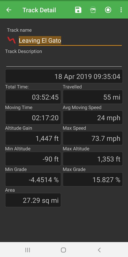
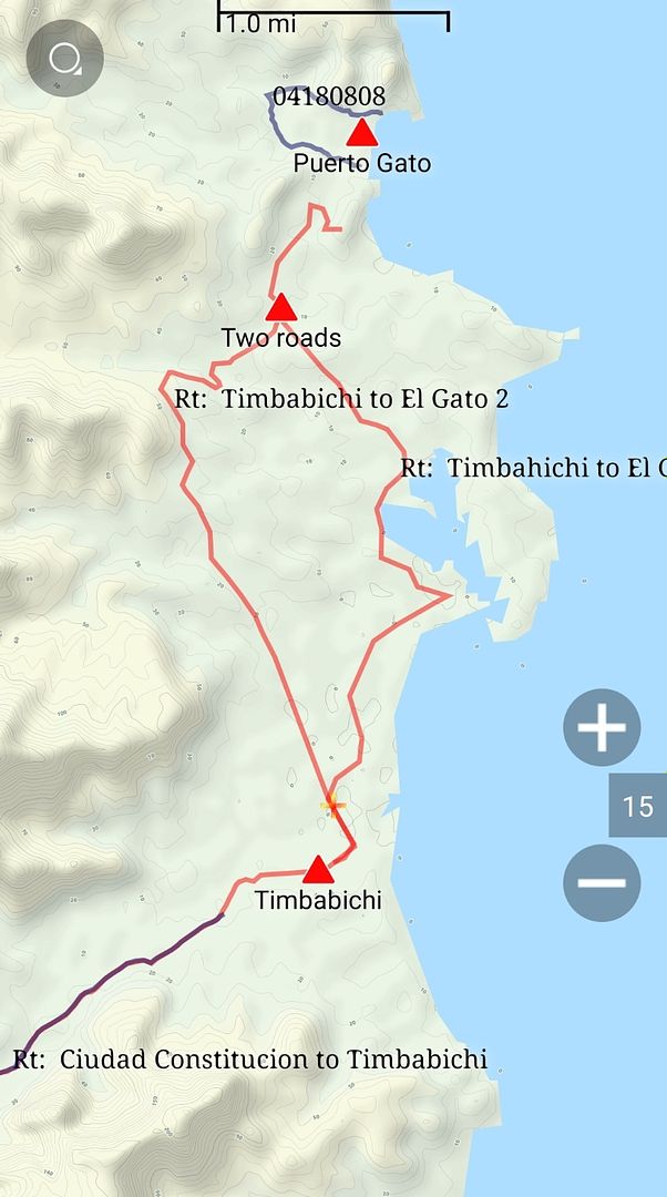
Here is the track info. This was from just a bit West of Timbabichi heading into Constitution. So you need to add 3-4 miles to that. The last 10 miles are payment.

Coming in we came from Loreto and cut the corner off bypassing Insurgents and Constitution.


[Edited on 4-20-2019 by JZ]

Mulege Canuck - 4-20-2019 at 01:16 PM

If your going to drive in there and it is getting late when you reach the canyon, camp at the second spur road on the ridge at the bottom. It has amazing views.

I cut the road out to get my camper in there. If you drive through Tembabichi and take the road north to Los Gatos you will follow my brushed route. It is really tight through the canyon for a full size camper. I recommend walking it first. It is only 900m.

C205Driver - 4-20-2019 at 01:47 PM

.... Map anyone?...

fishbuck - 4-20-2019 at 02:07 PM

Quote: Originally posted by C205Driver  
.... Map anyone?...


Check your WAC. 25 I believe.

Mulege Canuck - 4-20-2019 at 05:43 PM

Quick and dirty directions....

If heading south, turn left after the Ley in Constitution.

JZ - 4-20-2019 at 08:21 PM

Quote: Originally posted by Mulege Canuck  
If your going to drive in there and it is getting late when you reach the canyon, camp at the second spur road on the ridge at the bottom. It has amazing views.

I cut the road out to get my camper in there. If you drive through Tembabichi and take the road north to Los Gatos you will follow my brushed route. It is really tight through the canyon for a full size camper. I recommend walking it first. It is only 900m.


We rode that NW route from Timbabichi to Los Gatos, while the truck went along the coast. I had it on GPS, but saw the truck tracks - at the beginning. We rode it all the way until the 2 roads joined up again. The last mile was a b-tch. No tracks to follow and up and down the wash. My kid's bike was running on fumes, my phone/GPS hit 5%, and it was getting dark. Got a little scary. Thankfully we had a HH radio and the truck has a 50W radio.

The road to the East along the coast is MUCH easier.

Here is the area:


[Edited on 10-26-2020 by JZ]

JZ - 4-20-2019 at 08:29 PM

Quote: Originally posted by C205Driver  
.... Map anyone?...


PM me and I'll send you the track.

BajaRat - 4-20-2019 at 08:39 PM

Thanks JZ .
Good stuff .
Lionel :cool:

BajaMama - 4-22-2019 at 05:46 AM

Great shots, LOVE that road!

Mulege Canuck - 4-22-2019 at 08:46 AM

If planning a trip there, bring some used running shoes for the locals in Tembabichi. I was asked to bring some when we go back next year.

07E18676-FA40-4FCB-AE1C-94993AAF5BFD.jpeg - 122kB

Trunkrack - 11-7-2021 at 11:29 AM

Quote: Originally posted by 4x4abc  
Arroyo Puerto Gato is absolutely stunning (about 1.5 miles in from the beach)

North from Puerto Gato are a number of missionary time ranchos


Hi Harald, is the arroyo you're referring to at 25°18'29.57"N 110°58'21.13"W?

[Edited on 11-7-2021 by Trunkrack]

4x4abc - 11-7-2021 at 11:37 AM

that's the one

Trunkrack - 11-7-2021 at 11:41 AM

Thanks!

JZ - 11-7-2021 at 12:34 PM

Quote: Originally posted by Trunkrack  
Thanks!


Good bump and question. I just checked it out on Google Earth.

We are going to be there in the next couple weeks. Coming by boat. Not sure I'll walk up the arroyo, but might try to fly the drone out there to see if I can get some shots. It looks very cool.


4x4abc - 11-7-2021 at 02:19 PM

check if Rancho Carrizalito is still active
paradise location
25°20'44.13"N, 110°58'54.29"W

missionary times rancho
right on Camino Real

JZ - 11-7-2021 at 02:38 PM

I set a way-point for it. I'll check it out. Sweet location right by the ocean. Might try to ride the Zodiac up from Puerto Gato. It's about 4 miles.


[Edited on 11-7-2021 by JZ]

4x4abc - 11-7-2021 at 03:29 PM

there were a number of way stations/ranchos between Agua Verde and Los Dolores:
Santa Marta
San Felipe
San Francisco
San Mateo
San Gregorio
El Carrizalito
San Carlos
Puerto Gato
Santa Isabel (Timbabiche)

4x4abc - 11-7-2021 at 03:36 PM

very nice beach here:
25°22'4.11"N, 110°59'18.50"W

4x4abc - 11-7-2021 at 03:38 PM

I have a favor to ask - can you snap some pics of the cemetery at Los Dolores (Hacienda California)?
25° 4'22.03"N, 110°51'6.51"W

JZ - 11-7-2021 at 03:46 PM

Quote: Originally posted by 4x4abc  
very nice beach here:
25°22'4.11"N, 110°59'18.50"W


Picture perfect. Looks like a great spot to drop the hook.


JZ - 11-7-2021 at 03:49 PM

Quote: Originally posted by 4x4abc  
I have a favor to ask - can you snap some pics of the cemetery at Los Dolores (Hacienda California)?
25° 4'22.03"N, 110°51'6.51"W


I'll see what I can do. It's right next to Punta Colorado.

advrider - 11-7-2021 at 09:24 PM

Can anyone link the original trip report? I suck at searching on finding stuff on here. Looks amazing.

Trunkrack - 11-7-2021 at 10:42 PM

Quote: Originally posted by 4x4abc  
check if Rancho Carrizalito is still active
paradise location
25°20'44.13"N, 110°58'54.29"W

missionary times rancho
right on Camino Real


Ramon from Tembabichi took my wife and a couple friends and I up there in his panga in December of 2019, and there didn't seem to be any signs of life at that point. Was a cool place though, that fall the area had received a lot of rain and was really green in the area, knee to waist high grass we were hiking through up from the rocky beach there.

Trunkrack - 11-7-2021 at 10:47 PM

Quote: Originally posted by JZ  
Quote: Originally posted by Trunkrack  
Thanks!


Good bump and question. I just checked it out on Google Earth.

We are going to be there in the next couple weeks. Coming by boat. Not sure I'll walk up the arroyo, but might try to fly the drone out there to see if I can get some shots. It looks very cool.


We'll be there in the next few weeks as well, hopefully camped at the big palapa on the north end of the beach (was put in after GE imagery). Date is TBD depending on swell/wind on pacific side, but if you see us camped there, come up and say hi.


hombre66 - 11-8-2021 at 03:03 PM

Can this be reached from Aguas Verdes in a 2wd Tundra with good AT tires and good ground clearance?

JZ - 11-8-2021 at 03:39 PM

The Agua Verde back-door route has been washed out for several years, unless something changed recently.

We rode about half way up on bikes in 2017, but turned around because there was no way my truck was making it up it. You basically have to ride over huge rocks.

Coming in from MX 1 you can make it to El Gato in your truck no problem.


[Edited on 11-8-2021 by JZ]

4x4abc - 11-8-2021 at 04:19 PM

Agua Verde backdoor has been driven this year
reliable source

JZ - 11-8-2021 at 04:42 PM

Quote: Originally posted by 4x4abc  
Agua Verde backdoor has been driven this year
reliable source


Nice. What type of vehicle?

100X - 11-8-2021 at 06:11 PM

Yes, would love the details!

4x4abc - 11-8-2021 at 08:25 PM

Quote: Originally posted by JZ  
Quote: Originally posted by 4x4abc  
Agua Verde backdoor has been driven this year
reliable source


Nice. What type of vehicle?


Mercedes G400 (Diesel V8)
downhill
it wasn't smooth

geoffff - 11-8-2021 at 08:54 PM

Quote: Originally posted by 4x4abc  

Mercedes G400 (Diesel V8)
downhill
it wasn't smooth


Nice job!

Still too soon to drive my van up that hill?

4x4abc - 11-8-2021 at 10:05 PM

try downhill first - then you decide

geoffff - 11-8-2021 at 10:58 PM

I haven't seen this hill up close and in person, but I generally prefer uphills -- as I can change my mind and back down -- than downhills where I'm basically committed.