Mucho thread crossing and questions hidden in other threads. I thought a trip report by its self would be in order. We did this loop about a week ago.
We've done it in the Can Am and I've done portions of it on a motorcycle. The road is open and doable in a truck or SUV. Little bit of semi steep
switchback sections mixed with the typical wash beds strewn with bowling balls .
As you can see from the GPS screen shot, you can access the road from the road out of Palo Verde to the San Borjitas cave paintings or San Jose de
Magdalena. Unfortunately we didn't get out and look for the old ruins....I really need to figure out how to slow down!
TMW - 4-25-2019 at 09:30 AM
Thanks, looks like a fun route.David K - 4-25-2019 at 04:32 PM
The parallel route down/up to Guadalupe is what, road, m/c trail??
Let me add some maps that have names on them:
ZOOM IN:
San Borja (Borjitas) Cave site (arrow):
DouglasP - 4-25-2019 at 07:33 PM
I'm not sure of the name but you can see it on your map, it runs by Una de GatoDavid K - 4-25-2019 at 07:37 PM
I'm not sure of the name but you can see it on your map, it runs by Una de Gato
Yes, so how was that road?DouglasP - 4-25-2019 at 07:44 PM
River bed bottom, big rocks, but pick up truck passable. Saw a rancher doing it it a two wheel drive beater pulling a horse behind with two guys in
the back. Horse didn't look happy. Think they were training it.JZ - 4-25-2019 at 08:13 PM
It's a little hard to follow, as there are multiple loops / tracks in that image. And no waypoints for locations. Something like this would be
easier to follow. Is this the loop you did?
[Edited on 4-26-2019 by JZ]gueribo - 4-25-2019 at 08:56 PM
Thanks for posting the photos. One of my favorite drives in Baja. Glad it's open again.David K - 6-19-2019 at 11:28 PM
Just to confirm, we drove the loop from Mulegé to Mission Guadalupe from the south and back to Mulegé via San José de Magdalena in May 2019 (last
month). It was great... the reopened road down to San José de Magdalena is steep and narrow in places, 4WD traction would be best (especially if
going west/ uphill) but perhaps not mandatory. No passenger cars, however. MulegeAL - 6-20-2019 at 10:26 AM
DougP, good to see someone is having fun there! Hope to catch up with you down the rancho road sometime!
Yeah, from the San Borja cave painting road there's a cut off to the right to rancho Una de Gato, then a not very obvious exit from the next rancho
farther in. Rough but passable. Does not go through the box canyon, but it is a wild and scenic section unto itself. About a 60 mile loop as I
recall.
The "long way" round past the old mission site is just under 100 mile loop back to Mulege. Great bike loop, bring stout 4 wheel equipment otherwise.
Hope it survives the hurricane season again.4x4abc - 6-20-2019 at 10:55 AM
did you mean this one?
Attachment: 4x4 rural main washed out.kml (5kB) This file has been downloaded 314 timesDavid K - 6-20-2019 at 04:08 PM
No, that is the repaired road to San José de Magdalena from Guadalupe.
The short cut road goes by Rancho Una de Gato allowing a more direct trip between Mission Guadalupe and the San Borjitas cave.
I was looking for it and did see the side valley it was in, but didn't notice the road junction as we drove from Guadalupe to San José de Magdalena.
That is such a spectacular canyon, I think it was worth going the long way to get to San Borjitas, which we did that day, as well.
See the road in the "Cordillera de las Lagunas"?
[Edited on 6-20-2019 by David K]4x4abc - 6-20-2019 at 05:41 PM
I was relating to this one:
Just to confirm, we drove the loop from Mulegé to Mission Guadalupe from the south and back to Mulegé via San José de Magdalena in May 2019 (last
month). It was great... the reopened road down to San José de Magdalena is steep and narrow in places, 4WD traction would be best (especially if
going west/ uphill) but perhaps not mandatory. No passenger cars, however. 4x4abc - 6-20-2019 at 05:50 PM
for the shortcut you are referring to the road in Cañada la Puerta?
I was relating to this one:
Just to confirm, we drove the loop from Mulegé to Mission Guadalupe from the south and back to Mulegé via San José de Magdalena in May 2019 (last
month). It was great... the reopened road down to San José de Magdalena is steep and narrow in places, 4WD traction would be best (especially if
going west/ uphill) but perhaps not mandatory. No passenger cars, however.
Being it was under MulegéAl's post, I thought you were asking him.David K - 6-20-2019 at 06:13 PM
Yeah Harald, I think you got it right.
The "new" ten year old almanac labels it C. las Lagunas.
You would like it.
The rancheros at Una de Gato are great, I give then something every time through on bikes. Places like this are vanishing fast, but they got water.4x4abc - 6-21-2019 at 08:54 PM
yes, great people at Rancho Uña de Gato - but also Rancho Cantil Colorado (next one up north)DouglasP - 11-22-2019 at 03:35 PM
Well the road between San Jose Magdalena and Mission Guadalupe is washed out.
Coming from the Magdalena side the first steep switch back coming up out of the narrow canyon is wiped out. We were in side by sides and pressed
ahead even though the ranchers warned it was closed. Lots of big rocky washes with some rock crawling to get there, only to find the road washed out.
Standing in the bottom of the wash looking 20 feet up to the road bed still intact.
David K - 11-22-2019 at 04:39 PM
Thanks Douglas for the update. We were very lucky to get through last May. At the bottom of the grade, Cameron talked about how iffy that route was,
in Episode 1 of the Trail of Missions Recon on YouTube. We came in from the south to the mission then out via San José de Magdalena.4x4abc - 11-22-2019 at 04:57 PM
It's a little hard to follow, as there are multiple loops / tracks in that image. And no waypoints for locations. Something like this would be
easier to follow. Is this the loop you did?
[Edited on 4-26-2019 by JZ]
JZ, please use yellow or white for tracks - the standard colors are almost invisible for the color blind among us (almost 10% of the population) - a
track file is even betterDavid K - 11-23-2019 at 10:50 AM
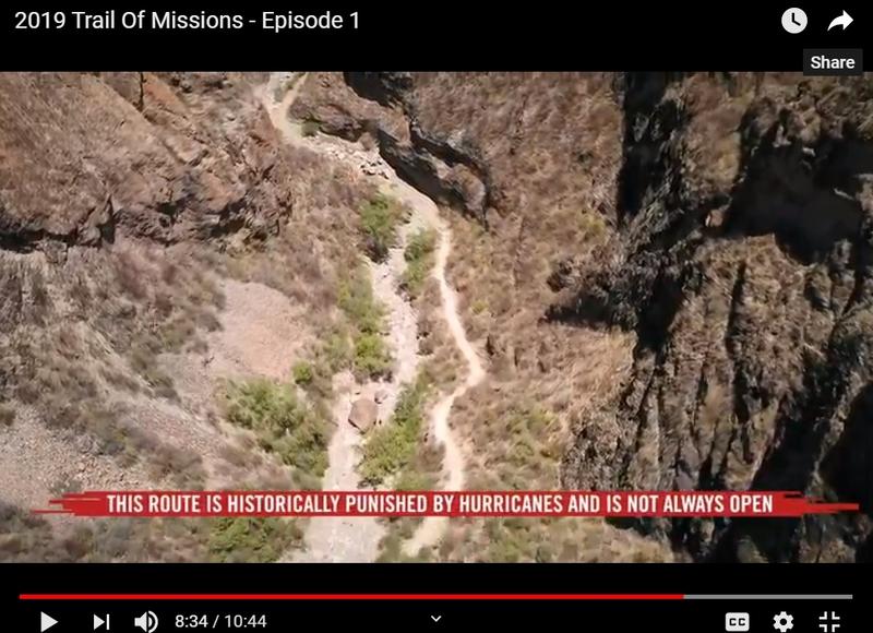
This washed out part of the road that was open last May appears between Minute 8 and 9 in Episode 1 and Cameron even talks about how this road is
easily washed out. It was just opened a year ago after about three years of being closed.
Here is a scene from the YouTube episode using a drone over the canyon. Note the caption at the bottom:
Here is the episode:
New question
DouglasP - 11-23-2019 at 11:29 AM
Kind of a thread jack, but it's my thread.
Does anyone know if its possible to get over to San Ignacio lagoon area going across the mountains? Not San Raymundo, something further north? David K - 11-23-2019 at 01:18 PM
Does anyone know if its possible to get over to San Ignacio lagoon area going across the mountains? Not San Raymundo, something further north?
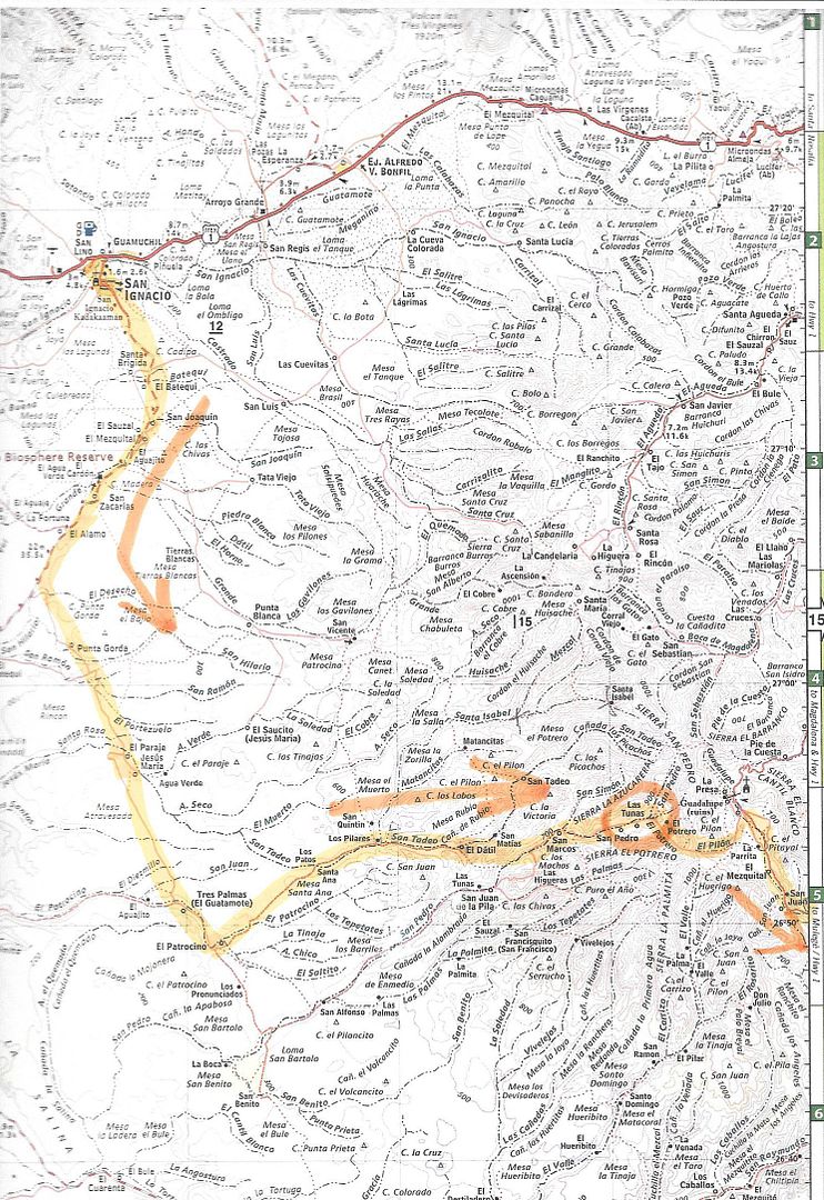
The road is reported only passable to motorcycles. It goes from just south of Mission Guadalupe west to Rancho Las Tunas then on down to El Patrocinio
and on to the Laguna San Ignacio highway, south of San Ignacio. Search posts by TMW and others for 'Tunas'.
Here is a map that TMW posted in one of those threads: