BajaNomad

Scorpion Bay info -driving from the North

steve5555 - 7-2-2019 at 06:42 AM

Hello everyone. I apologize for waiting till the last minute, but I need some logistics info. We are leaving mid morning today and take two days to get from Jamul to to Scorpion Bay for camping and surfing. A couple questions. We will probably come and go from he North. I have a F350 diesel 4x4 with oversized tires.

1. Is there a diesel gas station or barrels at Scorpion Bay?
2. Is the dry lake bed passable?
3. Is the campground on the bluff still operating at $10/person?
4. Anything else critical for me to know about the logistics?

Sorry that I need a quick reply. Thanks in advance. steve

Beagle - 7-2-2019 at 07:08 AM

Steve, try here as well:

https://www.facebook.com/groups/115118945166528/


David K - 7-2-2019 at 07:27 AM

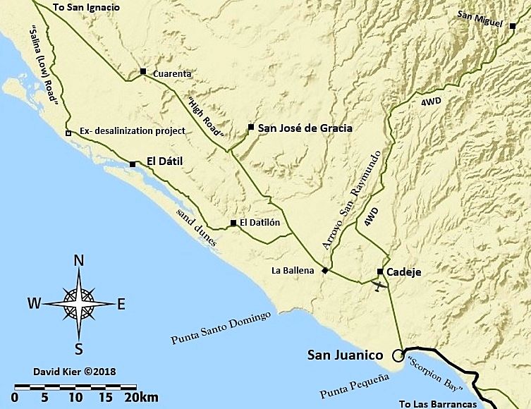
The graded ("High") road was repaired after my visit from the north (August 2017) making it the preferred route now.
Previously, the Salina ("Low") road was the recommended route that crosses over or along the edge of the tidal salt flats (not a dry lakebed).
Desert Bull is a regular here on Nomad who goes to San Juanico (Scorpion Bay) often.


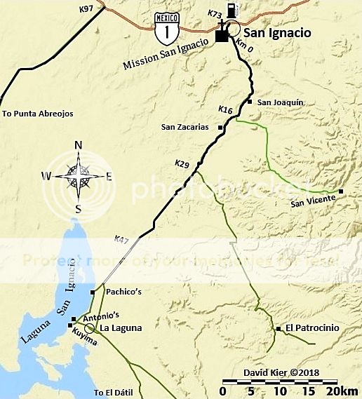
The road log from San Ignacio to San Juanico and on to Ciudad Insurgentes has been shared here on Nomad: http://forums.bajanomad.com/viewthread.php?tid=92377

steve5555 - 7-2-2019 at 08:00 AM

David, as usual great info thanks. I will print it out and stuff it in the truck! still wondering about gas and hope someone chimes in. :-)

Good info on the facebook link too, thanks

steve

BajaRun - 7-2-2019 at 08:33 AM

I have 300 mile range in my vehicle. I top off in San Ignacio and don't have a problem making the round trip. Some of the guys I go with buy fuel in San Juanico (gas not diesel) but I never do. I don't have info if diesel is available.

steve5555 - 7-2-2019 at 09:59 AM

Great. Leaving now. Thanks for the tips.

defrag4 - 7-2-2019 at 12:35 PM

There is a small tienda that sell gasoline in town, I do not think they have diesel though, I would not rely on it

steve5555 - 7-8-2019 at 07:28 PM

Well everyone, thanks for the good info, I got back earlier today. No consistent gasoline in San Juanico and did not see any diesel at all. Like the gent said earlier 300 miles of range was plenty for us in a round trip. There was purified water (20 pesos for 5 gallons) and bagged ice for 30 pesos at the same water place. We had a great trip and the swell that was supposed to arrive from a hurricane in the south was always... mañana. But still a friendly crowd and some good waist to chest high waves pretty much every day. Air in the 70's and eighties with the water in the low 70's.


DJI_0031.jpeg - 225kB

[Edited on 7-9-2019 by steve5555]

JZ - 7-8-2019 at 07:41 PM

Very nice pic. We went back and forth on whether we were going to run up there for a day or two. Decided to stick to the SoC instead. It wasn't that hot.


SMG - 7-9-2019 at 08:56 PM

Great pic! How's the sand?

So was the camping still available? How about the palapa rentals and restaurant?

Hoping to go back to SJ soon, it's been several years

joel - 7-9-2019 at 10:06 PM

Sand is terrible. Even 2nd is quite rocky at the moment. Only breaking on low tide, sadly. Bring sand!

Beagle - 7-10-2019 at 03:42 AM

Quote: Originally posted by joel  
Sand is terrible. Even 2nd is quite rocky at the moment. Only breaking on low tide, sadly. Bring sand!


At low does it still close out in the middle? 2 months ago it was closing in sorta that middle section most of the time. Not sure if it also was partially because of swell direction or just the bottom is so moved around.

Be back there in a week or so.

joel - 7-10-2019 at 01:36 PM

Yep. Even the modest swells we have had the past few weeks have removed more sand. I've seen it like this after hurricane season, but sad that we're starting at this level. Still fun, but just not as amazing as the past - and it means that the tide window is much narrower.

Quote: Originally posted by Beagle  
Quote: Originally posted by joel  
Sand is terrible. Even 2nd is quite rocky at the moment. Only breaking on low tide, sadly. Bring sand!


At low does it still close out in the middle? 2 months ago it was closing in sorta that middle section most of the time. Not sure if it also was partially because of swell direction or just the bottom is so moved around.

Be back there in a week or so.

ed26 - 11-28-2019 at 05:12 PM

Driving note: Have a buddy that lives in San Juanico 4-5 months a year and came out the Ranch road about two weeks ago. Told me it was in great condition, so we gave it a shot (have always gone salt flats in the past). From San Ignacio town square to the San Juanico in 2 1/2 hours, and NOT pushing it. The road was in very nice condition (all things considered), and with the huge high tides last week, the flats were very wet. No telling if the road will hold up, but it was a super easy drive this time, and apparently has been lately.

pacificobob - 11-28-2019 at 05:39 PM

Those maps are only part of the story. There is a very complex bunch of roads/tracks some of which are not seeing much use due to bottomless sand. Its suprr easy to make a wrong turn and end up having very damn little fun. Imo if i wanted to avoid burying a f350 , i would certainly have good nav resources. Its a very cool section, have fun.

4x4abc - 11-28-2019 at 06:31 PM

Quote: Originally posted by ed26  
Driving note: Have a buddy that lives in San Juanico 4-5 months a year and came out the Ranch road about two weeks ago. Told me it was in great condition, so we gave it a shot (have always gone salt flats in the past). From San Ignacio town square to the San Juanico in 2 1/2 hours, and NOT pushing it. The road was in very nice condition (all things considered), and with the huge high tides last week, the flats were very wet. No telling if the road will hold up, but it was a super easy drive this time, and apparently has been lately.


what is the "Ranch road"?

David K - 11-28-2019 at 07:18 PM

Quote: Originally posted by 4x4abc  
Quote: Originally posted by ed26  
Driving note: Have a buddy that lives in San Juanico 4-5 months a year and came out the Ranch road about two weeks ago. Told me it was in great condition, so we gave it a shot (have always gone salt flats in the past). From San Ignacio town square to the San Juanico in 2 1/2 hours, and NOT pushing it. The road was in very nice condition (all things considered), and with the huge high tides last week, the flats were very wet. No telling if the road will hold up, but it was a super easy drive this time, and apparently has been lately.


what is the "Ranch road"?


Yes, I would also like to know.
My maps show the low road (Salinas or salt flat road) and the government graded road or "High Road".

BajaBlanca - 11-28-2019 at 08:30 PM

What a gorgeous picture of the water!

Nikno - 11-29-2019 at 10:40 AM

In San Juanico the High Road is often referred to as the Ranch Road and the Low Road is referred to as the Salt Flats.

4x4abc - 11-29-2019 at 12:21 PM

Quote: Originally posted by Nikno  
In San Juanico the High Road is often referred to as the Ranch Road and the Low Road is referred to as the Salt Flats.


would you go through Rancho El Patrocinio on Ranch road?

David K - 11-29-2019 at 12:47 PM

Quote: Originally posted by 4x4abc  
Quote: Originally posted by Nikno  
In San Juanico the High Road is often referred to as the Ranch Road and the Low Road is referred to as the Salt Flats.


would you go through Rancho El Patrocinio on Ranch road?


This would be the road connecting Rancho Cuarenta to El Patrocinio, yes? It was used for the Baja 1000 not long ago.

Rufus T. Doofus - 11-29-2019 at 10:09 PM

We headed out earlier today from the La Heurta Hotel in San Ignacio towards San Juanico. The road is washed out and unpassable by any vehicles .5 km west of where the pavement ends. Looks like a section of culverts washed away with the recent rain. Looks like it's going to be a big project to get this road open any time soon.

We're hoping to get in to Scorpion Bay from the south if possible. Currently in Loreto and heading that way in a couple days.


[Edited on 11-30-2019 by Rufus T. Doofus]

Nikno - 11-30-2019 at 05:46 PM

Rufus: That's bad news. It will be very difficult for the communities south of there if that road does not get fixed soon, especially with whale watching season starting soon. Based on your description I tried to figure out where the washout is. Does this look about right?

26.936798, -113.075390

You can copy and paste the coordinates into Google Maps. Or do you have a more exact location?

I am heading down on December 14 with a group of doctors to run medical clinics in San Juanico and was planning on taking this route. Are you saying there is no way through from San Ignacio south/west? Did you ask the locals if there are any alternate routes?

Does anyone else have any current information about this situation?

David K - 11-30-2019 at 05:59 PM

If it was washed out just south of the end of the pavement, and north of the lagoon camps and the village, it is already fixed!
Washed out roads get detours or repairs immediately when a town like that is cut off.

Nikno - 11-30-2019 at 06:06 PM

That's what I'm thinking too. They need that road. I'm just going by what Rufus said. "Unpassable by any vehicles" and "a big project to get this road open any time soon".

If anyone has any pictures, please share.

David K - 11-30-2019 at 06:11 PM

Yes, thank you... I am also guessing that the end of the pavement is the same now as it was for me in 2017? Just before Km. 48, 30 miles from San Ignacio and 6 miles north of Pachico's whale camp entrance.

Rufus T. Doofus - 11-30-2019 at 09:37 PM

The first washout heading west was around km47/48. It's on a raised part of what was maybe a raised/graded dirt road. I parked and walked out 200 yards to where the road was washed out. I'd guess there was 60 to 70 feet of road missing with a good river of water flowing from south to north. Looks like the area is normally a salt flat. The road that day was a pile of rubble with no discernible surface.

There were two guys in a a government security pickup truck at the washout watching the water. I thought maybe I could make it in my old Land Cruiser. They said the water was 2 to 2.5 meters deep and there were a few other washouts after this one. Basically talking me out of something stupid and thinking I could head off into the water and make my own detour.

I don't know how long it would take for the mud to dry out in that area or for the water level to lower enough so they could repair it. Maybe that happens quickly. A detour onto the flat would be feasible with a layer of fresh stone and gravel. To replace what was lost at this first wash out would be a guess of 500 cubic yards of material or 45-ish tri-axle dump truck loads. I'g guess they can handle that fairly quickly for an emergency repair.

Nikno - 11-30-2019 at 10:18 PM

Thank you for the detailed update! That part of the salt flats is not great to drive on since it takes a long time to dry. Hopefully they can get some fill/gravel on there soon. I'm sure they will figure out a work around pretty quickly.

Skipjack Joe - 12-1-2019 at 06:50 AM

It could be this area. This wasn't far from the pavement.

DSC_0202_psd1 copy.jpg - 244kB

MulegeAL - 12-1-2019 at 09:55 AM

If the "causeway" down to the lagoon is blown out, I figure the low road south of the bay on the flats will be a mudfest for some time as well, best to follow the tracks of the local fisherman to the south.

Maybe try the road south through Patrocino? Safe travels.

David K - 12-1-2019 at 04:12 PM

I hope Desert Bull chimes in as he seems to go that way often...
It was his post in 2018 that informed us that the "High Road" (Government Graded Road) was regraded and now the preferred and faster route over the typically popular "Low Road" (Salinas or salt flat route).
The low road was fine for me in August 2017, but I kept to the inland side of the flats.

Desertbull - 12-3-2019 at 08:20 AM

Road to the whale camps and Salt Flats is washed out still ...

High #1 road via El Patracinio - Rancho Cuantra was open and clear a few days ago. I posted the video from Rancho Cuantra to El Patricinio on the @xplorz_ Instagram page.

The high road via el patracinio begins off the paved section before the current wash out.

Expect the wash out to be repaired this week ... I’m told Whale Season officially opens Dec 21 ...

Lotta construction on the San Juanico road between Cadaje - Ballena area as the government is building bridges over / thru the water crossings ... it’s the beginning of the construction of the alleged paved road from San Ignacio to San Juanico likely time take 40 years.


David K - 12-3-2019 at 09:53 AM

Thanks, Tim.

Funny about the paved road to San Ignacio from San Juanico is that it was a proposed paved highway back in the '70s. It provides a shorter/ faster route between La Paz and the north. The town's of Santa Rosalia, Mulege and Loreto protested that they could lose valuable business if they were bypassed. So, the idea was shelved.

Nikno - 12-3-2019 at 11:16 AM

Thank you for the update Desertbull.

What do you estimate the current driving time is from San Ignacio to San Juanico via El Patrocinio?

Desertbull - 12-3-2019 at 12:47 PM

It was about 45 minutes longer in a well setup vehicle with off road suspension. I just did it and timed it ... you still have to cross some washes that are typical Baja standard off road stuff, but far worse than standard Baja graded roads ...

mtgoat666 - 12-3-2019 at 02:17 PM

Article on the temp fix, with pictures...

https://www.elsudcaliforniano.com.mx/local/restablecen-el-pa...

mtgoat666 - 12-3-2019 at 02:20 PM

The rains were "epic" in sierra de san fran...

https://www.elsudcaliforniano.com.mx/local/llueve-intensamen...

Nikno - 12-3-2019 at 03:04 PM

Thank you. I will be passing through there in about 10 days. I will give an update on the repairs and any detours.

sledneck - 12-5-2019 at 05:55 PM

I passed through yesterday 12/4 left San Junico about 3pm, headed north solo. Road work in spots from Cadaje to the turn off to the the El Datil salt (mud) flats route. Lots of standing water in spots well before the flats. Got stuck in the mud once in the flats trying to go around standing water, nothing that a
Pacifico, shovel and al little patience couldn't handle. From what I could tell there were only one or two set of tracks ahead of me, I found that rather than going around the water spots looking for dryer ground (and sinking) was better to follow the tracks from the fishermen. through the water. Seemed to be much firmer there. I went through the repaired section just before the pavement at about 6pm. Lots of cows and horses after dark. I haven't seen Baja this wet in 30 + years, stoped to climb a hill and take a picture of Laguna Chapala full of water.

David K - 12-5-2019 at 06:02 PM

Please post the Laguna Chapala photo. I have some from BajaTripper taken the previous wet year (2010)... They come to the Californias every 7-12 years, it seems.

Rufus T. Doofus - 12-5-2019 at 09:36 PM

mtgoat666 - Thanks for the links to the articles.

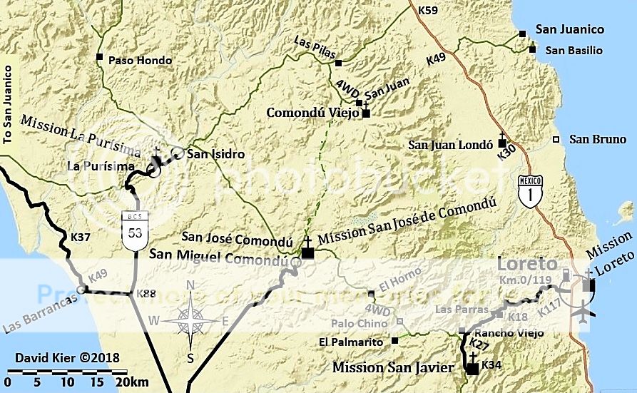
The paved roads from the south (53 and others) to San Juanico are in great shape. We spent a few days camping on the beach in San Juanico recently.