BajaNomad

Mine locations?

PaulW - 12-3-2019 at 09:58 AM

Has anyone found more references to the Pioneer Mine? Other than Gebhard & Gulick?
I found a list of 5 mines all generally located at Calamajue, but with no exact locations
They are:
Rey Salomón Mine, Calamajue - Calcite, Chrysocolla, Galena, Gold
King Richard Mine, Calamajue – Gold Gebhard & Gulick mentioned
Josefina Mine, Calamajue - Gold
Calamajue, - Calcite, Chrysocolla, Galena, Gold, Malachite
San Antonio Mine, Calamajue - Chrysocolla, Galena, Gold, Malachite


Nikno - 12-3-2019 at 10:37 AM

I found a mine ruin at:

29.62480, -114.26880

I thought it was the Pioneer Mine but it might be a different one. If anyone knows the name of that mine, please post.

And then there is the gold mine opposite the Calamajue Mission site at:

29.42491, -114.19850

I don't know the name of that one but I'm sure DK does.


David K - 12-3-2019 at 10:45 AM

Quote: Originally posted by Nikno  
I found a mine ruin at:

29.62480, -114.26880

I thought it was the Pioneer Mine but it might be a different one. If anyone knows the name of that mine, please post.

And then there is the gold mine opposite the Calamajue Mission site at:

29.42491, -114.19850

I don't know the name of that one but I'm sure DK does.
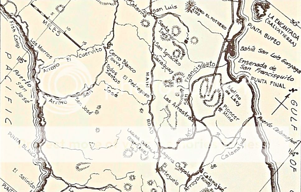


That is a gold ore mill, not the mine... Molino de Calamajué. The 1970 Baja Guide by Cliff Cross thought it was also the mission ruin site. In a follow-up edition, he corrected the error and said the mission was indeed across the arroyo from the mill.

David K - 12-3-2019 at 10:59 AM

Quote: Originally posted by PaulW  
Has anyone found more references to the Pioneer Mine? Other than Gebhard & Gulick?
I found a list of 5 mines all generally located at Calamajue, but with no exact locations
They are:
Rey Salomón Mine, Calamajue - Calcite, Chrysocolla, Galena, Gold
King Richard Mine, Calamajue – Gold Gebhard & Gulick mentioned
Josefina Mine, Calamajue - Gold
Calamajue, - Calcite, Chrysocolla, Galena, Gold, Malachite
San Antonio Mine, Calamajue - Chrysocolla, Galena, Gold, Malachite


Gerhard & Gulick give exact locations for both King Richard and Pioneer mines (page 85, 4th edition). King Richard was Dick Daggett's mine. Equipment and supplies were shipped in from Guaymas and landed at Puerto Calamajué. Edward Nelson and Arthur North both mentioned Daggett in their books about their 1905-06 expeditions.

The 1992 book 'Modest Fortunes' (#51 in the Dawson Book series) describe the mines of the area and provide old newspaper reports on them, on pages 184-188.

David K - 12-3-2019 at 11:09 AM

Looking through books:

Page 29 of 'Rockhounding in Baja' by W.R.C. Shedenhelm, La Siesta Press, c1980. Las Arrastras, La Josefina, and Pioneer mines are mentioned.

David K - 12-3-2019 at 11:16 AM

Page 26 of 'Lower California and its Natural Resources' by Edward Nelson mentions the King Richard Mine.

PaulW - 12-3-2019 at 01:30 PM

Is "Arrastras, La Josefina" an Arrastras (mill) or the mill & the mine or just the mine La Josefina?
Missing mention so far Rey Salomón mine.
BTW, the Pioneer mine was located by Harald with coordinates. It was on one of the Pioneer trail threads.
Hard to plot the mines on Google with just road descriptions.

David K - 12-3-2019 at 01:39 PM

Las Arrastras de Arriloa, Molino de Lacy (de San Francisquito), and Molino de Calamajué are Mills to process ore from nearby mines.

King Richard (aka 'La Josefina') and Pioneer Mine, are actual mines.

I never heard of Rey Salomón before.

4x4abc - 12-3-2019 at 02:03 PM

there is one guy who knows ALL the mines in the area - Coco

PaulW - 12-3-2019 at 03:35 PM

Here is where I got my mine list and does not show Pioneer
https://www.mindat.org/loc-14346.html

David K - 12-3-2019 at 05:41 PM

Quote: Originally posted by PaulW  
Here is where I got my mine list and does not show Pioneer
https://www.mindat.org/loc-14346.html


That's not a very useful map... Has five listings at one point.

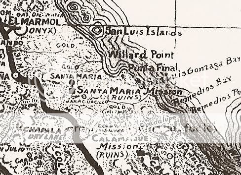
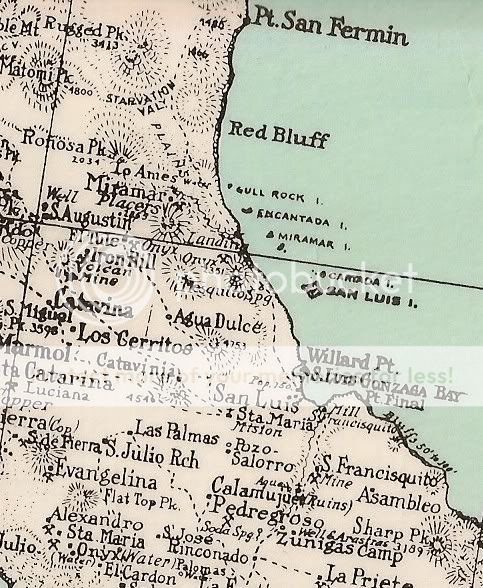
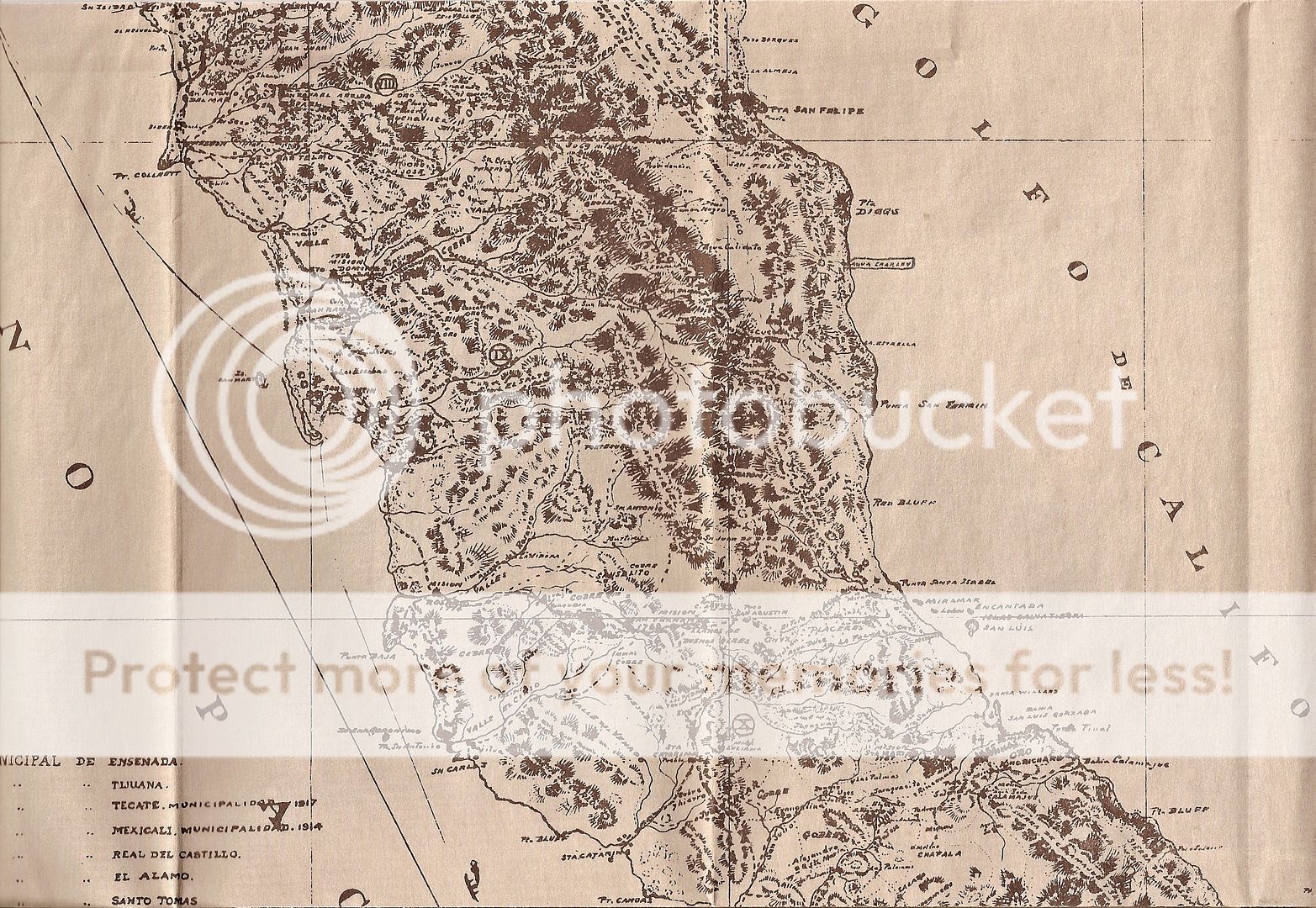
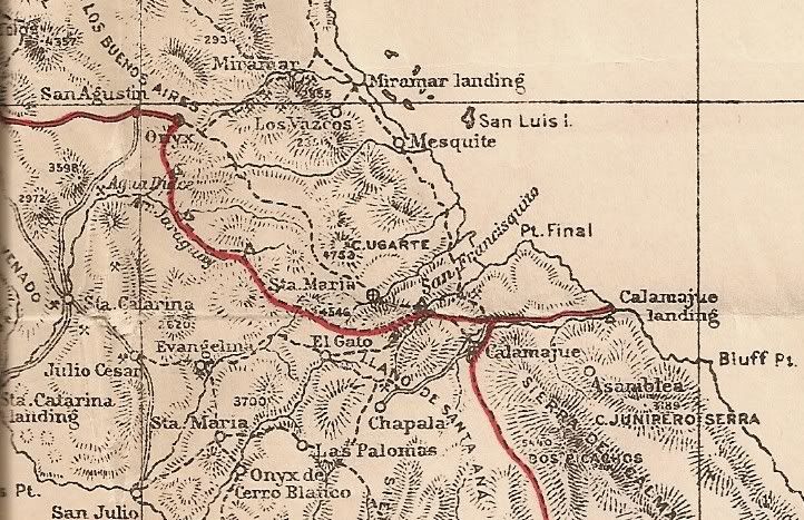
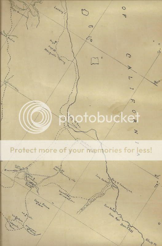
Here are some historic maps of the area:


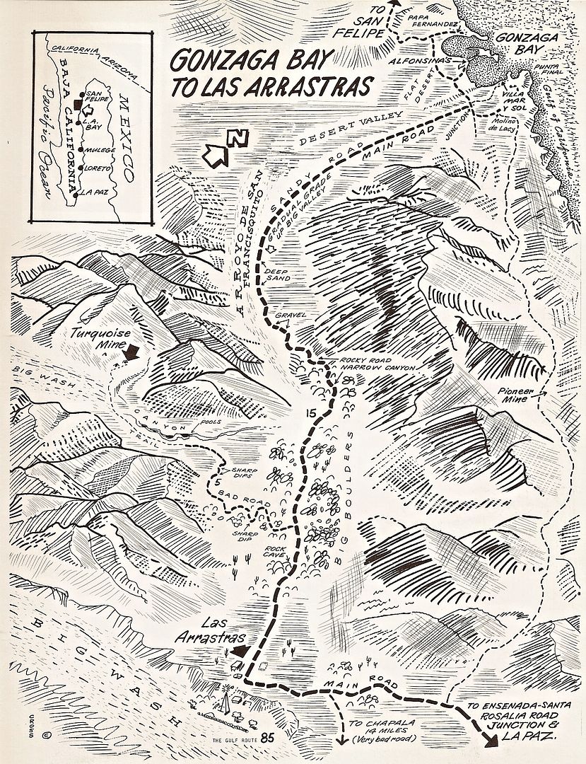
The mine symbol south of Pioneer Mine is King Richard/ La Josefina.
This is the 1962 Gulick map.


1970 Cliff Cross map. Pioneer Mine is on the right.


1941 Map showing GOLD locations


1930 Map


1919 Map


1905 Nelson Expedition map.


1905 Mine Map, calls Pioneer Mine "San Francisquito"


4x4abc - 12-3-2019 at 06:56 PM

Pioneer Mine 29.62480, -114.26880
Mina La Josefina - King Richard 29°32'53.70"N, 114°13'58.49"W

StuckSucks - 12-3-2019 at 08:50 PM

Pioneer Mine 29.62480, -114.26880
Mina La Josefina - King Richard 9°32'53.70"N, 114°13'58.49"W

4x4abc - 12-3-2019 at 11:08 PM

here is what I have in the area:

Attachment: some.kmz (5kB)
This file has been downloaded 248 times

bajaric - 12-4-2019 at 08:54 AM

Hey guys! Lets talk mines! I just happen to be researching that area right now. Paul, I looked at the mine dat web site and the reference cited for the Rey Solomon mine was book by Panczner (1987) Minerals of Mexico. Its fifty bucks on Amazon. I doubt if it shows an exact location. There are probably dozens if not hundreds of claims around there and the names tend to change over time as new owners work them.

I also looked at some Pioneer Mine threads. Harald has a link to a great description of the trail on Smugmug, it is a little glitchy to get it to show but if you search manly-men it is possible to see some great pictures including some mine portalss. Harald, I am wondering something; you describe a small valley with several mines. Is this the Pioneer Mine where coordinates are shown above by you and also Nikno? I also see smugmug has your pictures for sale. What is up with that. Can I buy one and use it in a book?

There is some evidence that the mine shown on the BCA near the original site of the Calamajue Mission named El Toro may have been worked in missionary times. It was worked in 1874, which is really early in terms of Baja mining, the owner must have been tipped off that it was there because someone remembered the old mine of the Padres.


David K - 12-4-2019 at 09:16 AM

If there was any mining by the Spanish or missionaries, it would have been during the Dominican/Spanish period (1773-1822) as the Jesuits and Franciscans kept good records as to where everyone was at and doing what. There is not one mention of mining by them in the region, at least the Jesuits. Oh, there were notes about minerals seen but their time was fully involved with producing enough food for them and their flock. Sadly, they usually did not have enough food to maintain many at the head mission. Dominican records are either non-existent or have not been found yet that describe daily life, beyond the book by Padre Sales.
By the 1840s, mainlanders were coming to Baja to make a living for themselves. The lore of Spanish or Mission Mines is strong but the facts are not yet found that show any mining north of La Paz by them. Real de Santa Ana and San Antonio were the silver mines of the 1740s and later and the exception on the peninsula during the mission period.

4x4abc - 12-4-2019 at 10:39 AM

starts about here:
https://carlosnpainter.smugmug.com/Events/Manly-Men-Baja-201...

the "valley" I have in mind

Attachment: San Francisco mining claims.kmz (2kB)
This file has been downloaded 253 times

To buy pictures is a standard feature on smugmug
haven't used it yet as I usually sell entire sets or articles

but I'll entertain the idea of selling any pic you need

4x4abc - 12-4-2019 at 10:44 AM

let me repeat - the best source for mine locations and mine names in the area is Coco
I am certain that INEGI has everything on file as well
or the catastro in Ensenada

bajaric - 12-4-2019 at 12:07 PM

Quote: Originally posted by 4x4abc  
starts about here:
https://carlosnpainter.smugmug.com/Events/Manly-Men-Baja-201...

the "valley" I have in mind


To buy pictures is a standard feature on smugmug
haven't used it yet as I usually sell entire sets or articles

but I'll entertain the idea of selling any pic you need


Cool. I am slowly, slowly working on a book, tentatively entitled "Exploring the Gold Districts of Baja California Norte" (yeah, I know, it is technically "Baja California") and if I ever get to the point of publishing it will PM you regarding use of your photographs. There really is not much money in a niche book like this, it is more of something to keep me occupied in retirement. Small limited production run books may sell a few hundred copies then used books start popping up on Amazon, undercutting the price of a new book and the author makes no money on it. That is why Harry Crosby just cleaned out a garage full of his books. Why buy a new one when you can get a used one for half the price.

bajaric - 12-4-2019 at 12:25 PM

Quote: Originally posted by David K  
If there was any mining by the Spanish or missionaries, it would have been during the Dominican/Spanish period (1773-1822) as the Jesuits and Franciscans kept good records as to where everyone was at and doing what. There is not one mention of mining by them in the region, at least the Jesuits. Oh, there were notes about minerals seen but their time was fully involved with producing enough food for them and their flock. Sadly, they usually did not have enough food to maintain many at the head mission. Dominican records are either non-existent or have not been found yet that describe daily life, beyond the book by Padre Sales.
By the 1840s, mainlanders were coming to Baja to make a living for themselves. The lore of Spanish or Mission Mines is strong but the facts are not yet found that show any mining north of La Paz by them. Real de Santa Ana and San Antonio were the silver mines of the 1740s and later and the exception on the peninsula during the mission period.


Maybe the Dominicans whipped the Indians because they were not mining fast enough. lol

There is a pretty solid argument that someone in the Jesuit Missionary period located a gold deposit at Calamajue. If not the Padre, then one of the soldiers. I do not believe the Dominicans had a presence there, as Calamajue was abandoned before the Jesuits were expelled. It was reported that a gold mine was operated there in 1874 (Modest Fortunes, quoting 1874 newspaper San Diego Union Tribue) The odds of a prospector just randomly stumbling across a gold mine in Calamajue 1874 are almost nil. The area was uninhabited, and it would have been a stroke of amazing luck to find an out crop of gold ore in the vast, barren desert around that area in 1874. (Most valuable mineral deposits are located where people already live, by accident e.g. Sutters Mill, The Boleo Deposit, El Alamo etc etc.) Why would someone have been wandering around Calamajue in 1874 looking for gold?. Gold in Northern Baja had yet to be discovered, other than at Real del Castillo, in 1871. Not at El Alamo, not at Calmalli. The likely explanation is that someone in Guaymas, an old port town that served the Missions, remembered a tale told by some ancient grandparent about the gold mine of the Padres spoken by some soldier who brought back an ore sample after his service was up, and someone picked up on it and went there specifically to look for gold, and found it. That is my story and I am sticking with it.

David K - 12-4-2019 at 12:30 PM

That's not accurate about Harry's books.
He was not selling his books, Sunbelt was.
A truck showed up one day and dropped off all the books that I now have. Harry's daughter contacted me as they wanted the garage space back. I just hate seeing Baja books trashed.

As for your book title, you could put Norte like this (Norte) after Baja California or call it of Northern Baja California? I wish you great look and would like to buy a signed copy from you.

If I can help you or connect you with anyone who I have worked with in publishing and distributing my book, let me know.

David K - 12-4-2019 at 12:39 PM

Calamajué: the Jesuits were only there from October 1766 to May 1767... They moved the mission to Santa María and then were forced to Loreto that December. When I say "they" we are speaking of one Jesuit at Santa María. He joined others who were taken to Mexico City then on to Europe. Each mission had usually only one Jesuit. 16 were all of them at the time of their extraction from California.

4x4abc - 12-4-2019 at 02:29 PM

half the Enchanted Valley is slate rock - almost a guarantee for gold
Jesuits were educated enough to know that

Mines/drilling - San Felipe area

PaulW - 12-4-2019 at 05:17 PM

Drilling locally in October this year.

Salar del Diablo Lithium

https://www.juniorminingnetwork.com/junior-miner-news/press-...

Results for the drill holes is undergoing analysis and not reported at this time.
The company doing the work is based in Vancouver Canada.
No record of any other reference to lithium mining in Baja.
=== == ==
San Felipe mine
Just north of Hwy 3 is the gold mine named Minera Frisco

http://www.minerafrisco.com.mx/Paginas/ES/nuestro_negocio/un...

April 2019 - Premier Gold Mines has signed an agreement to acquire an option to purchase a 100% interest in the San Felipe Property from Americas Silver Corporation.
https://www.premiergoldmines.com/
based in Canada
https://www.americas-gold.com/contact-info/
based in Canada
Several claim groups form part of the San Felipe Property and consist of 16,265ha with multiple poly-metallic zones that host a historic mineral resource.
https://www.mining-technology.com/news/premier-gold-san-feli...
Hochschild is the money bags company located in London

Better Link! Molino de Lacy story:

David K - 12-4-2019 at 07:42 PM

www.sanfelipe.com.mx/articles_stories/Articles2002/kinson/se...

PaulW - 12-5-2019 at 07:46 AM

DK
Ha, I am surprised you were able to dig out the articles on the website. Thanks for doing that.
Did you find any other than 2002?

David K - 12-5-2019 at 08:33 AM

Quote: Originally posted by PaulW  
DK
Ha, I am surprised you were able to dig out the articles on the website. Thanks for doing that.
Did you find any other than 2002?


I was very proud of myself, indeed! LOL!
I remember reading the article years ago and simply did a web search, and there it was. Now, the link to it was altered by my Norton security and my website host couldn't unlock it. So, I simply played with it by removing odd characters (%2F) and replacing them with a slash / and it worked! I asked my host to save the link (two web pages) to VivaBaja.com on my links page: http://www.vivabaja.com/davidslinks.html

I didn't look for other articles... But if I find any and can fix them to view, I will... If you find any, send them to me. You have my email? Use info AT vivabaja.com as that will redirect to my email.

PaulW - 12-5-2019 at 09:00 AM

How I got there
Link I used
http://www.sanfelipe.com.mx/articles_stories/Articles2002/in...
The only thing I found was 2002

Rob is a good guy and have met him several times. One time he helped me with SCORE marking. Have not seen him for several years.

David K - 12-5-2019 at 09:57 AM

Nice!

Here is a good story from your list:
http://www.sanfelipe.com.mx/articles_stories/Articles2002/ca...

I knew Arnold who was the unofficial "mayor" of San Felipe, it seemed... back in the 1960s. He had Arnold's Del Mar hotel and restaurant. Seems everyone ate at Arnold's back then? It was Arnold who told my parents about the Matomí waterfalls and drew notes of it in my dad's Lower California Guidebook. It was my personal quest to go after I was driving to Baja! I got to the canyon in 1978 and up to the falls the next year.

wiltonh - 12-8-2019 at 07:57 PM

I know this thread is about mines in Northern Baja but I spent several hours going through the mining museum in El Triunfo. The name is Mueso Ruta de Plato and it opened about one year ago. They give the history of mining in the area with names and dates and a few maps. They show about a 15 minute video and there are 3 or 4 Microsoft Surface machines with pictures and presentations of mining and other related subjects. The presentation on water in BCS is also very interesting.

As I was leaving I asked the woman in the gift shop if they had a map of the mine above La Ventana. She placed a call and in a few minutes the curator showed up. His name was Juan Jose Cabuto and he spoke good English. He introduced himself as a mining engineer. He has the permits to survey all the mines in the area for the Mexican government.

I asked him some specific questions about the mine above La Ventana and it was obvious he had been in the mine and had mapped out some of the air vents.

It was an interesting place to visit as they took you through the changes in mining technology that had happened.


4x4abc - 12-8-2019 at 11:54 PM

Quote: Originally posted by wiltonh  
I know this thread is about mines in Northern Baja but I spent several hours going through the mining museum in El Triunfo. The name is Mueso Ruta de Plato and it opened about one year ago. They give the history of mining in the area with names and dates and a few maps. They show about a 15 minute video and there are 3 or 4 Microsoft Surface machines with pictures and presentations of mining and other related subjects. The presentation on water in BCS is also very interesting.

As I was leaving I asked the woman in the gift shop if they had a map of the mine above La Ventana. She placed a call and in a few minutes the curator showed up. His name was Juan Jose Cabuto and he spoke good English. He introduced himself as a mining engineer. He has the permits to survey all the mines in the area for the Mexican government.

I asked him some specific questions about the mine above La Ventana and it was obvious he had been in the mine and had mapped out some of the air vents.

It was an interesting place to visit as they took you through the changes in mining technology that had happened.


main thing I took home from visiting the museum was the importance of salinas in Baja. Always wondered why Baja has so many big salinas. Now I know. Mining.

Jack Swords - 12-9-2019 at 11:43 AM

http://www.vivabaja.com/swords/page11.html

Baja Sur has many very old mining areas (other than Triunfo). Several of us have explored the mines and mining equipment over the years. Valle Perdido has mines and machinery as does the Real de Santa Ana (however very old and overgrown). David's VivaBaja site has many of the photos, including dry washers found abandoned near El Arco. There are still active gold/silver mines in the area. Exploration of these areas will require your ability to speak Spanish and develop a relationship with the locals. Caution: we did encounter unknown gasses in one mine.

wiltonh - 12-9-2019 at 06:56 PM

I got too close to one of the active mines a few years ago and was met with guards with guns. They were not happy I had found them. The pond near the mine had that funny chemical look.

The water discussion centered on the fact that there 280,000 people in La Paz and on a year with out a hurricane they are short more than 10%. They also said that of the total water that falls on La Paz only 10% ends up in the aquifer. They listed about 6 dams that have been built to capture the water. In the case of the Las Palmas dam there is no outlet other than the overflow. They are recharging the aquifers from those dams.

They did mention the water pollution caused by the mines. This happened in the late 1800 or early 1900. It was caused by a direct hit from a hurricane which caused their storage ponds to break and the water flowed down over Las Planes. The picture they put up showed the bones of a dead cow sitting in a field with nothing growing. That hurricane ended the large mining in the area. Many of the mines were flooded and there was a large loss of equipment.

It seemed to me that the museum was describing history much more than pushing for any more mining.