BajaNomad

Any way to drive 4x4 from Laguna Hanson to Laguna Salada?

steve5555 - 12-28-2019 at 08:10 PM

All, Ive got a new little 4WD buggy and want to explore out of Tecate tomorrow. If I get up to Laguna Hanson is there any possibilities to get down into the dessert other than the turn off almost at Ojos Negros?

thanks, steve

David K - 12-28-2019 at 08:47 PM

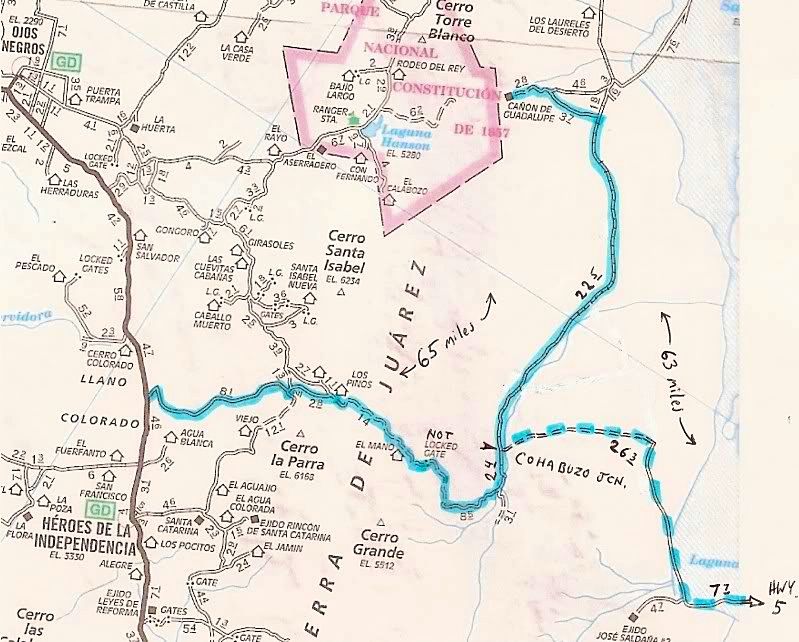
Yes, down Mano Canyon. The Baja 1000 just used it to come up. It is very rough.


https://caltopo.com/map.html#ll=31.80783,-115.66569&z=15...

[Edited on 12-29-2019 by David K]

KasloKid - 12-28-2019 at 09:30 PM

Take a set of chains with you.. a good chance you'll run into snow :o

Maderita - 12-29-2019 at 02:12 AM

Steve,
El Mano canyon is a long way around and will burn a lot of time and fuel. Daylight is short. Many miles beyond the frequently traveled routes. Would not advise doing this with a solo vehicle. You could be tens of miles from help.
There were several inches of snow at La Rumorosa 2 days ago (4,000' elev). Most of that has probably melted off by now. South of La Rumorosa, the plateau rises to over 5,000'. At that elevation, the road will be a mixture of snow and mud. 4x4 or rear locking diff required.
If you are solo, a more sane route is to take the dirt road SE from La Rumorosa, past the municipal dump (basurero municipal). The road is steep, but 2WD when unaffected by weather/erosion. It descends a canyon eastward to the desert.
Perhaps drive south from La Rumorosa toward Laguna Hanson. Turn westward just beyond the KM 35 sign to Rancho El Topo. Visit the ranch. Ask Beto (I believe Ricardo is at Laguna Salada tending his livestock) to point you toward the "mirador" viewpoint. South of the main ranch buildings a 2 or 3 miles. 4x4 required to ascend the hill. There is also a 4x4 long hill to the NW, above Gavilanes, 3 or 4 miles from the ranch buildings.
Refuel back at La Rumorosa and decide if you want to take the dirt road to the desert/Laguna Salada. Or, have a good meal and a beer at La Cabana del Abuelo nextdoor to the Pemex.
Feel free to call me with questions. I'm in those locations about two weekends per month, over several decades.
-John (edited to remove phone number)

[Edited on 12-29-2019 by Maderita]

[Edited on 12-29-2019 by Maderita]

steve5555 - 12-29-2019 at 07:55 AM

David, thanks for the link and at the risk of sounding like a green horn wow that topo is new to me and pretty outrageous!

John, thanks for the trip routing and detailed response. I hear you that I need to use some caution since El mano is far off the normal path. I may pass that route for this trip. I will probs head down the compadre trail and see how the conditions are. I usually turn left at that rancho (Beyond rancho santa veronica-with the big oaks and that little stream that crosses the road)and wind my way up to the lake. I may stop by Ricardo's place and then out the back way as you suggest. Ive been through there a few times on my dirt bike. I might do that. Anyway, Ive got my camping gear for and overnighter and I will see how it plays out. I will report back!

Thanks again, steve

advrider - 12-29-2019 at 09:15 AM

Make sure you have some recovery gear. I've taken compadre trail many times on my bike, last year we were on our 500's when it rained on us all day. That road became a real challenge and super slick. 4wd would have been ok but there were some spots that could have been a challenge and you might have had to self recover out of a couple of ditches.
I'm sure while you were getting unstuck some local would drive by in a 2wd car on bald tires.... LOL.

David K - 12-29-2019 at 11:08 AM

Steve, as John said, it is a long way around, but the only road from the top to the desert south of La Rumorosa (until the 'summit' road Portezuelo de Jamau). I did post GPS directions for it way back after I drove it in 2003: http://www.vivabaja.com/GPS/ (note, this was when we were posting at Map Datum NAD27 Mexico. Neal Johns recommended that so it would match with the topo maps which are drawn at that datum. Google Earth and the standard GPS setting is at WGS84. Make sure to switch settings when entering the these waypoints from that page).

http://www.vivabaja.com/GPS/page2.html

Guadalupe Canyon access via Graded Rd @ Mex.#2: 32°34.33'/ 115°47.35'

Guadalupe Canyon access via Laguna Salada Dry Lake Rd. @ Mex.#2 (south turn, next 5 waypoints): 32°34.57'/ 115°44.63'

Jcn. Graded road & south end of Dry Lake road: 32°13.06'/ 115°42.24

Guadalupe Canyon Entrance: 32°09.40'/ 115°47.29'

Cohabuzo Jcn: 31°55.74'/ 115°36.22'

South of Cohabuzo 8.2 mi. is a fork, go right for El Mano (4WD): 31°49.81'/ 115°33.89'

Jcn. with road to left. Ahead-right goes up the mountain via El Mano canyon: 31°47.68'/ 115°36.65'

Rancho El Mano driveway left, road begins major climb: 31°48.56'/ 115°40.39'

Rancho Los Pinos, elev. 5,086': 31°48.77'/ 115°46.26'

Jcn. Santa Catarina left (S)/ Agua Blanca right (SW): 31°45.20'/ 115°51.52'

Jcn. Agua Blanca left (S), Hwy. 3 right (N): 31°42.24', 115°54.25'

Map Datum: NAD27 Mexico


Map routes show the distance to Guadalupe Canyon from Hwy. 3 or Hwy. 5, is almost the same. The Mano Canyon road is shown on the AAA map.

[Edited on 12-29-2019 by David K]

PaulW - 12-29-2019 at 11:35 AM

DK,
Thanks for that. Heading that way soon and needed the Hwy3 and S Catanina coords. I have to remember to convert to wgs84.
We will start from Cohabuzo side, but have not decided which route to take to start Mano.

David K - 12-29-2019 at 12:43 PM

Hi Paul, you can go to the mission which is accessed from Independencia via a concrete road now. From the Santa Catalina mission, near the village of Santa Catarina (note the different spelling), you go north to meet the highlighted route I took. The map doesn't show the mission site but it is just past the village to the NE, above the cemetery. See my Trip #8 report on Nomad.

[Edited on 12-29-2019 by David K]

PaulW - 12-29-2019 at 02:09 PM

BTW, traditionally there is a locked gate at Mano summit. Unlocked for the latest two races. Norra 2013 and Score 2019.
After the Norra race the ranch owner has provided access for small groups when asked.

David K - 12-29-2019 at 05:18 PM

Quote: Originally posted by PaulW  
BTW, traditionally there is a locked gate at Mano summit. Unlocked for the latest two races. Norra 2013 and Score 2019.
After the Norra race the ranch owner has provided access for small groups when asked.


Good to know. Is this the nice ranch near the high point, Los Pinos?
In 2003, the only gate was the one shown as a 'locked gate' on the AAA map, well down the desert side of the grade. It was open, no lock to worry about.

4x4abc - 12-29-2019 at 05:26 PM

can we gate a location for the gate?

PaulW - 12-30-2019 at 07:26 AM

My interest is because I have not been across the Mano summit. I think the summit is =
31 48.69247', -115 41.68146' @ 4117'. Got this from a message from a SCORE race blog, and it looks pretty close when Google Earth is consulted.
I wonder how close the gate is to that place?

PaulW - 12-30-2019 at 07:38 AM

My community is with explorers on the east side and I was led to believe is where the rancher lives. I need to make some contacts to locate the ranch and get first hand details on the gate location. None of the racers I have contact with were not part of the arrangement details to get the gate opened.

Quote: Originally posted by David K  
Quote: Originally posted by PaulW  
BTW, traditionally there is a locked gate at Mano summit. Unlocked for the latest two races. Norra 2013 and Score 2019.
After the Norra race the ranch owner has provided access for small groups when asked.


Good to know. Is this the nice ranch near the high point, Los Pinos?
In 2003, the only gate was the one shown as a 'locked gate' on the AAA map, well down the desert side of the grade. It was open, no lock to worry about.

steve5555 - 12-31-2019 at 12:39 PM

Hey Gents, Im back. I didn't look for the route down to the dessert from the lake but if anyone wants to do that over a weekend, Id be up for exploring. I have the buggy below. Anyway, some pics from my trip. Should be titled, "snow and mud".


steve5555 - 12-31-2019 at 01:03 PM


IMG_0312.jpeg - 174kB

steve5555 - 12-31-2019 at 01:05 PM


IMG_0317.jpeg - 208kB IMG_0318.jpeg - 132kB

steve5555 - 12-31-2019 at 01:07 PM


IMG_0332.jpeg - 233kB IMG_0343.jpeg - 117kB

steve5555 - 12-31-2019 at 01:08 PM


IMG_0351.jpeg - 187kB IMG_0362.jpeg - 100kB IMG_0363.jpeg - 150kB IMG_0365.jpeg - 217kB IMG_0385.jpeg - 216kB

Mano Canyon Trail Report

Ken Cooke - 12-31-2019 at 01:22 PM

If this is the same route that I had climbed several years ago after visiting Canon Palomar, there was a fork in the road traveling uphill. Please confirm I am talking about the correct trail - Going left (southwest) is less of a steep climb than going straight (west). Continuing straight (west), one comes to a stairstep climb with 8"-10" stairsteps requiring double locking differentials to the top of stairstep. In a short wheelbase Jeep, it scared the @~#! out of me. All three Jeeps (with 4:1 transfer case gears and locking differentials front/rear) made it through that section. We passed the burned up Suburban SUV at the top of the hill. I took photographs most of the way up for the memories!:!:

TMW - 12-31-2019 at 01:45 PM

Wow Steve nice pictures, thanks.

David K - 12-31-2019 at 01:50 PM

Ken, Mano Canyon is where I was leading your group from Guadalupe Canyon with a desire to reach the summit (2003?). You hiked up to the waterfall of the Virgin that morning and with such a late start for the Jeep run, we only got to the lower end of the canyon. You Jeep guys found a boulder you all could drive one tire up onto for photo opps. The fellow in the Isuzu (name?) and me in the Toyota just watched as had fun talking there.

[Edited on 12-31-2019 by David K]

Maderita - 12-31-2019 at 02:02 PM

Great photos Steve, thanks for sharing. I see that you made it to El Topo. Did "Calcia" (the brown dog) great you? Was Beto tending the ranch alone? The ranch has been thin on help for several weeks. Your Honda 4x4 looks quite capable, a nice rig for exploring. Open-air always feels more adventurous. Very cool.

Ken Cooke - 12-31-2019 at 03:26 PM

Quote: Originally posted by David K  
Ken, Mano Canyon is where I was leading your group from Guadalupe Canyon with a desire to reach the summit (2003?). You hiked up to the waterfall of the Virgin that morning and with such a late start for the Jeep run, we only got to the lower end of the canyon. You Jeep guys found a boulder you all could drive one tire up onto for photo opps. The fellow in the Isuzu (name?) and me in the Toyota just watched as had fun talking there.

[Edited on 12-31-2019 by David K]


Based on past photographs (Nov. 2013) and information from local guides (Saturnino Valdez, for one) I believe you took us to a much closer canyon and not Mano Canyon back in 2004.


David K - 12-31-2019 at 04:08 PM

It was Mano... I was following my GPS points from the drive down the year before. That is why you asked me to lead since I had the recent and GPS knowledge of how to get there from Guadalupe.

When we took a left fork, I was thinking it was to the stone cabin but it was a bit too soon and it ended where that boulder was. About here is where the big rock was:

https://caltopo.com/map.html#ll=31.80227,-115.659&z=14&a...

https://caltopo.com/map.html#ll=31.80252,-115.6581&z=16&...


[Edited on 12-31-2019 by David K]

Ken Cooke - 12-31-2019 at 04:17 PM

Do you recognize this gate?


David K - 12-31-2019 at 04:26 PM

It looks like it could be the site of the formerly locked gate (on the AAA map)?

Ken Cooke - 12-31-2019 at 04:29 PM

Quote: Originally posted by David K  
It looks like it could be the site of the formerly locked gate (on the AAA map)?


Is that Mano Canyon?


A stone cabin is below this washout/off-camber section


Stairstep section about 1/2 mile downhill of this location


Top of long grade

David K - 12-31-2019 at 04:33 PM

YES Ken! Right before Rancho El Mano
The AAA map is in this thread. [reposted here]
Locked Gate (I added "NOT" to it)...


[Edited on 1-1-2020 by David K]

Ken Cooke - 12-31-2019 at 04:38 PM

Quote: Originally posted by David K  
YES Ken! Right before Rancho El Mano
The AAA map is in this thread. [reposted here]
Locked Gate (I added "NOT" to it)...


The AAA map is irrelevant - actual landmarks are more useful in this varied region.

steve5555 - 12-31-2019 at 04:45 PM

Quote: Originally posted by Maderita  
Great photos Steve, thanks for sharing. I see that you made it to El Topo. Did "Calcia" (the brown dog) great you? Was Beto tending the ranch alone? The ranch has been thin on help for several weeks. Your Honda 4x4 looks quite capable, a nice rig for exploring. Open-air always feels more adventurous. Very cool.


El topo was busy with about 10 vehicles and a number of families wondering around so I didn't stop long. I asked for Ricardo and if I could pass and then I was on my way. Id like to take my wife back there for some horse back riding. She likes to ride and it looks like some cool scenery.

It kind of seems like we should organize a trip to tackle Mano canyon! :-)

steve

steve5555 - 12-31-2019 at 04:50 PM

The other thing that was notable was the amount of Mexicans up at the Lake in all SORTS of vehicles. The road to/from Ojos had mud fields 10 inches deep if you fell into a rut. 100-200ft long. Probably 20-30 of this sort on the way.

Literally I saws a couple of honda civics and a number of CRV type vehicles. They would get highsided/stuck in a mud bog; people would pitch in to unstuck them and then they would keep going up! It was incredible.

The next morning as I traversed the lake - all of them gone. Like magic.

Steve

David K - 12-31-2019 at 05:15 PM

Quote: Originally posted by Ken Cooke  
Quote: Originally posted by David K  
YES Ken! Right before Rancho El Mano
The AAA map is in this thread. [reposted here]
Locked Gate (I added "NOT" to it)...


The AAA map is irrelevant - actual landmarks are more useful in this varied region.


Not to me, as the AAA map actually correctly shows the road I traveled (highlighted in blue) and provides the name (Mano) which was what you were looking for. I also gave links to satellite and topo maps that also named the canyon "Mano" the road climbs up from.

Between the Jamau Summit Road (1942 Pole Line Route) and La Rumorosa, the Mano Grade is the only road from the desert to the pine forest.

[Edited on 1-1-2020 by David K]

PaulW - 12-31-2019 at 07:54 PM

The real track
Here is the east side track used by 2013 NORRA and 2019 SCORE

the fish that wouldn t die

Maderita - 12-31-2019 at 08:16 PM

Steve, check your U2U

David K - 1-1-2020 at 09:26 AM

Paul, the road climbs even higher than the 4,117' summit you showed. The next ridge to the west, near Rancho Los Pinos, brings you to over 5,000'.

Ken Cooke - 1-2-2020 at 01:56 AM

Pole Line Road - up El Jamau trail shown in first 3 minutes of video.


PaulW - 1-2-2020 at 03:05 AM

Quote: Originally posted by David K  
Paul, the road climbs even higher than the 4,117' summit you showed. The next ridge to the west, near Rancho Los Pinos, brings you to over 5,000'.

== =
Yes - Mis-placed marker. Not my WP.

Tijuana 4x4 El Topo Jan 2020 video

Ken Cooke - 1-2-2020 at 11:02 PM

I heard El Topo mentioned. Here is a video released recently by Tijuana 4x4 Club. One of their members attended my 'El Imposible' run in February 2019. He drives a 2007 Rubicon 2dr JK on 38" BFG KM2s and Rubicon Express long arm suspension. Here is their video.