BajaNomad

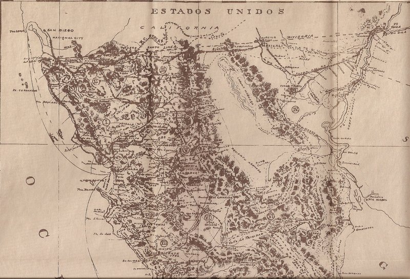
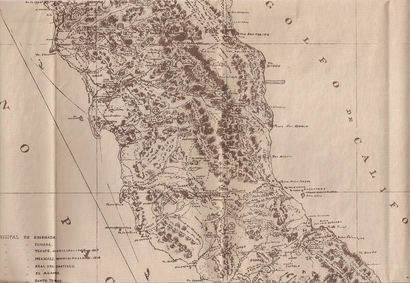
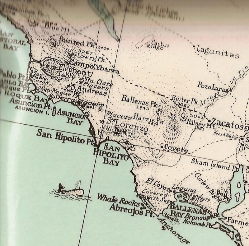
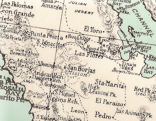
1925 "corrected" Goldbaum map

David K - 1-2-2020 at 12:39 AM

Excellent!

Doug can move this post to the Historic Interests & Maps forum.

David K - 1-2-2020 at 12:13 PM

Juan, the link is a great one and I have added to my website to make finding it easy, in the future: 1918 Goldbaum Baja Norte 'Zoom-In' Map

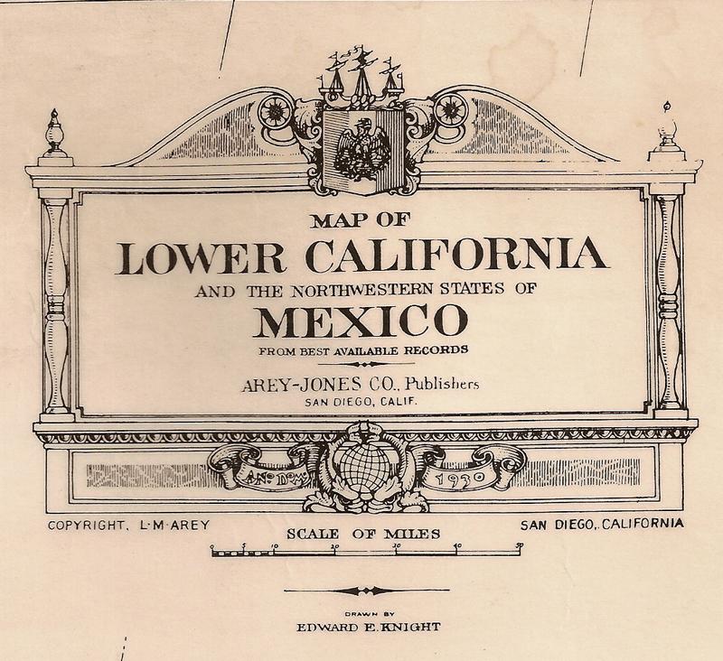
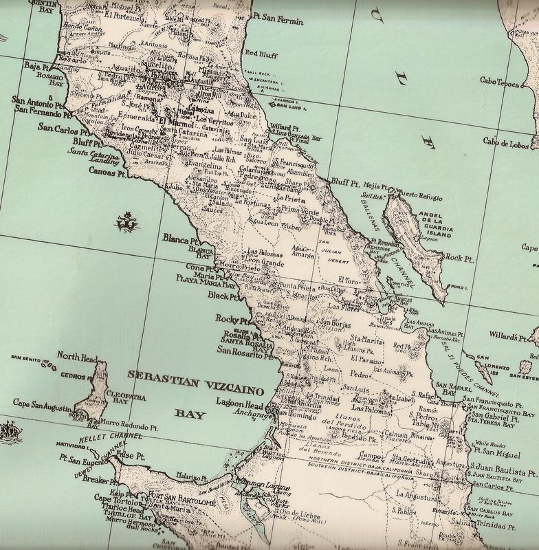
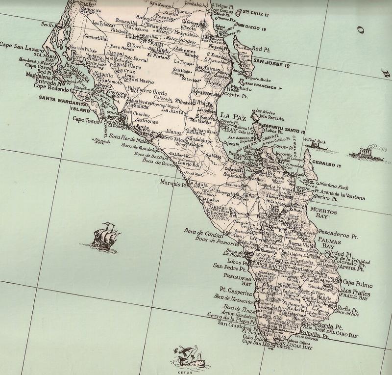
Have you seen the 1930 Baja map (entire peninsula)? If you find it online with the zoom-in feature, please let me know!

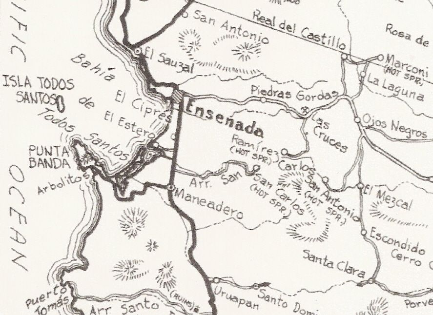
Here are some samples from it:


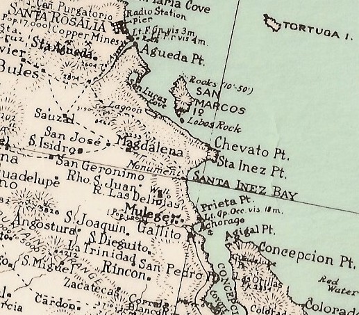
Up close:


4x4abc - 1-2-2020 at 12:37 PM

entertaining - but the 1925 map has so many serious mistakes that it can not be taken seriously

David K - 1-2-2020 at 01:13 PM

Quote: Originally posted by 4x4abc  
entertaining - but the 1925 map has so many serious mistakes that it can not be taken seriously


Well, it was hand drawn from 20 years of travels by David Goldbaum, who lived in Ensenada (street named after him).
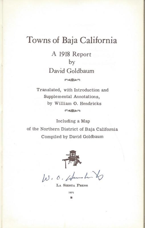
Read more about his Baja Norte research in this book from La Siesta Press, in
1971:


David K - 1-3-2020 at 12:40 AM

Great contributions!:light:

bajaric - 1-3-2020 at 06:37 AM

Great maps. I tried to save the "1925" map but it seems to only save in low resolution, no zoom. Guess I could snip hi res sections and stitch them together. These are good for identifying turn of the century place names that have since changed. e.g. Agua Dulce, near Real del Castillo, now called Agua Caliente, if that is the same place.

David K - 1-3-2020 at 11:04 AM

Quote: Originally posted by bajaric  
Great maps. I tried to save the "1925" map but it seems to only save in low resolution, no zoom. Guess I could snip hi res sections and stitch them together. These are good for identifying turn of the century place names that have since changed. e.g. Agua Dulce, near Real del Castillo, now called Agua Caliente, if that is the same place.


Ric, I added the map link to www.vivabaja.com and it is zoomable so try it there. You do have to click on the Expand arrows to make the map full page, first.
As for Agua Dulce (Sweet Water)... that would be a spring of drinking water and not a hot spring (Agua Caliente), typically. I will take a look, so thanks for asking!


[Edited on 1-3-2020 by David K]

bajaric - 1-3-2020 at 12:08 PM

DK, on closer examination you are probably right. Agua Caliente is in Arroyo Jacalitos. What Goldbaum called Agua Dulce appears to be a few miles southeast of there. Probably a spring that supplied water to Real del Castillo back in the old days, possibly at what is now shown as Agua de Cruz in the BCA. I wonder if anyone has ever been to that hot spring called Agua Caliente.

David K - 1-3-2020 at 12:26 PM

I see 'Jacalitos'... but not 'Agua Caliente' there or near there?
There is the Marconi Hot Springs (or was, reported not open or running) in the general area NE of Ojos Negros. Then the hot springs near the L.A. Cetto winery in Guadalupe Valley (aka 'Russian Valley Hot Springs').
The hot springs in San Carlos Canyon, SE of Ensenada are shown.

bajaric - 1-3-2020 at 12:44 PM

Agua Caliente is not shown on the Golbaum map; it is shown in the BCA, NE of Ojos Negros in Arroyo Jacalitos. Jacalitos is on the Goldbaum map. Maybe the same hot spring is called Marconi if I remember right by Gulik ?? - I know there is a hot spring thread that shows where I am talking about

edit, ahh there it is. Have been researching around this area recently so just happened to have remembered

http://forums.bajanomad.com/viewthread.php?tid=79289#pid9874...

Marconi it is -- the same, according to Gulik the same place called Agua Caliente on BCA

[Edited on 1-3-2020 by bajaric]

David K - 1-3-2020 at 02:05 PM

Quote: Originally posted by bajaric  
Agua Caliente is not shown on the Golbaum map; it is shown in the BCA, NE of Ojos Negros in Arroyo Jacalitos. Jacalitos is on the Goldbaum map. Maybe the same hot spring is called Marconi if I remember right by Gulik ?? - I know there is a hot spring thread that shows where I am talking about

edit, ahh there it is. Have been researching around this area recently so just happened to have remembered

http://forums.bajanomad.com/viewthread.php?tid=79289#pid9874...

Marconi it is -- the same, according to Gulik the same place called Agua Caliente on BCA

[Edited on 1-3-2020 by bajaric]


Fun to connect the dots over the years!

4x4abc - 1-3-2020 at 02:59 PM

what is BCA?

David K - 1-3-2020 at 04:48 PM

Quote: Originally posted by 4x4abc  
what is BCA?


My guess is 'Baja California Almanac'...

geoffff - 1-4-2020 at 12:12 AM

Quote: Originally posted by bajaric  
Great maps. I tried to save the "1925" map but it seems to only save in low resolution, no zoom. Guess I could snip hi res sections and stitch them together. These are good for identifying turn of the century place names that have since changed. e.g. Agua Dulce, near Real del Castillo, now called Agua Caliente, if that is the same place.


On the UWM website, if you click the download icon to the left of the print icon, it shows me three sizes. If I choose the last one (large) I get the full-size image.

-- Geoff


David K - 1-4-2020 at 11:43 AM

Geoffff, is there a way to add the El Camino Real routes as a layer onto the CalTopo map as hiked by Genevieve and Kevin of https://caminorealbaja.com/
Google Earth: https://caminorealbaja.com/waypoints/

David K - 1-4-2020 at 01:17 PM

The 1905-1906 Nelson/Goldman expedition map is also online with zoom-in feature!
https://collections.lib.uwm.edu/digital/collection/agdm/id/3...

David K - 1-4-2020 at 05:18 PM

Quote: Originally posted by Juan N.  
Great!
That trip report is available online as well if anyone wants to read it. Begins on page 13.

https://babel.hathitrust.org/cgi/pt?id=hvd.32044072259542&am...


The grand nephew of David Goldman produced a film about the expedition and how they retraced the steps to see what has changed between 1905 and today. The film is on the film festival tour now and will be showing in San Diego soon. Nomads have seen many previews of the film, called The Devil's Road. I might have a bit in it as they did film an interview with me a couple years ago. My book was their source for mission data.Pancho of San Rafael is in the film and in this preview...


bajaric - 4-7-2020 at 09:58 AM

Geoff, I was able to save the map in high resolution. Thanks for that tip.

I tried to make it to the "Marconi Hot Springs" near Real del Castillo a few months ago, but did not make it. I saw a post on the hot springs thread that there is not much to see there but I wanted to see for myself. Started in Tecate round 9am, drove east to Condor then south on a rough dirt road. Those fires last October created a huge burn scar in the Sierra Juarez, it was not reported very much but it was a big, hot fire; thousands of acres burned. You could see all kinds of tin cans and stuff laying around where the undergrowth was burned off. I got so engrossed in looking around lost track of time, then headed south past Laguna Hanson but by the time I got to the turnoff to Real del Castillo it was getting dark. Made it to km 55 on Hwy 3 and then to Ensenada in the dark, got stuck in huge Friday night rush hour traffic jam, finally got to friend's place at Bufadora around 7:30 pm. Will have to try it again some day when travel restrictions are lifted.

bajaric - 4-27-2020 at 01:05 PM

Juan M. thanks for posting the map from the Gabb expedition. I happened to be reading that account on line, after I found a reference to it in the appendix of a book that J Harper brought to my attention; The Central Desert of Baja California, Homer Aschmann.

For the history buffs sitting around covid bound, the Gabb report can also be seen here, starting on page 834 of this Harvard-digitized edition of Browne's monumental Lower Resources of the Pacific Slope.

start Gabb, 1867 report page 834:

https://babel.hathitrust.org/cgi/pt?id=hvd.32044072258460&am...

Account of a trip up the peninsula, along the old Mission Trail aka El Camino Real, including from San Ignacio to San Borja

I have a question for DK / Max or anyone else who might know regarding the Mission bells. Gabb noted some abandoned prospecting for minerals around Mission San Fernando, and another source said that copper was mined there by the Missionaries, and used for cooking implements and even some of the bells for the later missions. Ever heard of that?


[Edited on 4-27-2020 by bajaric]

David K - 4-27-2020 at 02:00 PM

Copper was mined not too far south of Mission San Fernando around 1900-1910 time period. I visited the San Fernando mine 20 years ago. A couple photos of it are on my website.

I don't recall the padres ever writing they had anything to do with mining. They were so involved with raising food, nothing else such as mining was possible.

To smelt the ore into metal was beyond their capability, I think.
Bells are bronze, I think, and forged either in Europe or on the mainland. I can ask Max!

David K - 4-29-2020 at 11:12 AM

Quote: Originally posted by bajaric  


I have a question for DK / Max or anyone else who might know regarding the Mission bells. Gabb noted some abandoned prospecting for minerals around Mission San Fernando, and another source said that copper was mined there by the Missionaries, and used for cooking implements and even some of the bells for the later missions. Ever heard of that?


From Max Kurillo... the bell expert!

A little bit of background,

The people in Peru had the art of metal casting quite perfected since about the year 600, they even brought the skills to the Guaymas area and all the way up to headwaters of the Gulf, all of this happened about the year 900. The metal casting was confined to small objects, mainly bells no larger than 3”. This technology remained in Senora region. There is no record of it being transferred to Indians of Nevada or California.

Now! New Mexico is different, they had roving metal casters that went from city to towns, (ca 1700-1800) casting large bells, 12” to about 20”, some are displayed at the Museum of New Mexico in Santa Fe. Others are stored at Hearst Castle in CA.

I do not find any solid proof that metal casting of bells was done in Baja California during the Spanish mission period (1697- 1825+/-), for so many reasons.

I would safely say, if anyone took the time to look at all the bells that are now in the missions of Baja none would be inscribed “Hecho en Baja California” or be blank. All the old bells, in the missions of Baja and Alta California, were brought from Mexico or other countries. Peru was the most popular location to order bells from.

People that think bells were cast in early California do not know of the complex steps in casting bell, of any size. Bell casting is one of my most complete and best subjects, I have written published articles about bell casting.


bajaric - 4-30-2020 at 11:11 AM

Thanks for asking Max Kurrillo about that, DK. I met you and Max at the book signing in Pt Loma, I tend to agree with Max, regarding the bells. It is not too likely that any bells were cast in Baja by the Missionaries. Nonetheless, in the book Modest Fortunes a newspaper article (Los Angeles Evening Express, 1895) was quoted the said the following:
"At San Fernando Mission …. it is said that nearly all the mission bells in this district as well as in California were wrought in a primitive way by its priestly coppersmiths. On of the bells at the Rosario Mission is marked "El Rosario" and dated 1810, was founded at San Fernando, and all the bells at the Santo Domingo Mission were from the same place"

Highly unlikely that bells in Alta California were made at San Fernando, or any bells, for that matter, though copper was mined there. For one, the Padres would have needed not only copper, but tin, to make the alloy of bronze. Also, all of the scholarly sources are in agreement that the Padres main concern was with feeding the converts, and mining as an economic activity was not a priority. Aschmann went so far as to say that the missionaries actively discouraged mining, as there was not enough food for both miners and Indians. It is significant to note that the lucrative business of silver mining and pearl fishing in Baja Sur was carried out not by the missionaries, but by private individuals, lending credence to the idea that mining for economic gain was not on the missionary's agenda.

That not to say that the missionaries did no mining at all. They mined lime (Sea shells) and roasted it in kilns to make mortar, they dug clay for adobe, quarried stone, and did a limited amount of salt mining on one of the islands, and they may have even mined a little copper, but it was all in the interest of supporting the missions, not accumulating wealth. This is the prevailing opinion of anyone who has studied the subject. Of course, everyone loves a good lost treasure story.

Also while it is almost certain that the Jesuits did not economic mining in the later period of the Dominicans there was more of a chance that some mining took place, and even copper-smelting.

I might add, that the gold and silver in Northern / Central Baja was not easy to find back then. It is not easy to find today! Aschmann, a trained geologist, passed very near several large placer deposits and failed to notice them. It was not like the mother lode in Northern California where every stream was loaded with gold; the gold of Baja was buried deep in dry arroyos in some of the driest, most inhospitable country on earth. Even if the Padres had wanted to do a little mining on the side it would not have been an easy task to even find it.

[Edited on 4-30-2020 by bajaric]

David K - 4-30-2020 at 03:26 PM

My pleasure, Ric.

I have pages 62-63 open of Modest Fortunes. I love the photo of the bells but wish they gave a location and date for the photo! Where are those bells now? The story of a foundry there is pretty far fetched, at least for making bells.

El Rosario had two mission bells in the early 1960s, then just one. It was said that the townspeople sold one for some needed income.

I don't think I read anything about bells from Mission Santo Domingo? It was one of the last missions to remain roofed with an altar inside.

Generally a town elder would keep mission artifacts, like bells or altar pieces, hidden for protection. At some point either a priest or government official would show up and insist those items be entrusted with them.

The mission books were collected in this manner by California church officials and protected... until the San Francisco Earthquake and Fire consumed them! Fortunately, the data was saved by others and appear in history books.

4x4abc - 7-23-2021 at 12:00 AM

do we have a download link yet for the 1918 Goldbaum map?

David K - 7-23-2021 at 09:52 AM

Quote: Originally posted by 4x4abc  
do we have a download link yet for the 1918 Goldbaum map?


It is on my website, Harald. 1925 printing of the 1918 map.

4x4abc - 7-23-2021 at 11:26 AM

looking for the original 1918

David K - 7-23-2021 at 03:10 PM

Quote: Originally posted by 4x4abc  
looking for the original 1918


It is in brownstone and not as easy to read. I have scanned parts of it over the years. It is in the book, Towns of Baja California.

I will post part of it so you can see how it compares to the 1925 printing of it.

4x4abc - 7-23-2021 at 07:18 PM

easily fixed with light settings and contrast

1925-Ojos-Negros.jpeg - 157kB

David K - 7-24-2021 at 10:05 AM


4x4abc - 7-24-2021 at 04:57 PM

can you please email those images - the resolution here is bad for my eyes

David K - 7-24-2021 at 05:22 PM

You bet!