It has occurred to me now that most travelers are using the Hwy 5 route - given the big decrease in traffic passing through such places as Cataviña,
El Rosario, etc what will be their fate?
I suppose that agriculture will continue to sustain areas such as San Quintin but AFAIK Cataviña depends solely on tourism & ranching and is
probably the most vulnerable.PaulW - 4-21-2020 at 09:03 AM
Probably true
However, I think the word is not out yet based on the low traffic volumes on Hwy 5David K - 4-21-2020 at 10:02 AM
There is still a ton of traffic to and from Tijuana, Ensenada, and SoCal that will use Hwy. 1. However, there is a big chunk of travelers that will
use Hwy. 5 now. bajaric - 4-21-2020 at 10:38 AM
There are still a couple of impediments to the average tourist using Hwy 5. For one, there is a lack of hotels in the range of a one day drive from
Mexicali. There is one expensive hotel, and a couple of budget bungalows that may or may not be open on any given day. So you have to either pull up
short and stay in San Felipe, or camp, or try and make it all the way to Guerrero Negro, which is a long trip to do in one day.
The other thing is a complete lack of services. No cell phone, no towing service, no ambulance, so it is a little more risky than taking the more
populated route on Hwy 1. All this will change, of course, as the black asphalt claims another piece of paradise.Marc - 4-22-2020 at 07:44 AM
The BOLA turn off might be a good location. Resurrect the gas station & would be good for a motel/restaurant.ehall - 4-22-2020 at 12:30 PM
Let's wait and see what mother nature has in store in Oct and Nov. The road could easily change in 1 day.pacificobob - 4-22-2020 at 12:46 PM
I often say ones local knowledge of remote roads and trails in baja is only valid until the next hard rain.Tioloco - 4-22-2020 at 01:52 PM
I often say ones local knowledge of remote roads and trails in baja is only valid until the next hard rain.
100% spot-on! That road between San José de Magdalena and Mission Guadalupe is an excellent example. Washed out in 2015, tried to use it in 2017 (not
a chance), repaired in late 2018, washed out again in late 2019! So glad I got to travel it during the short window it was good (Mid-2019)! RFClark - 4-22-2020 at 04:15 PM
Hwy 5 has washed out at least 5 times since we been going down south of San Felipe. Before the shutdown truck traffic was heavy. Even before the road
was completed we drove from Todos Santos to north of Loreto in one day and were home the 2nd night. (South of SF). I wouldn’t drive across to either
Enseneda or TJ after dark also north of Jesus y Maria on Hwy 1,wilderone - 4-23-2020 at 08:07 AM
What ric said. For tourists, Mex. 5 vs. Mex. 1 are very different trips for what one intends to get out of their travel dollars. And not every
trucker is going to the Mexicali border. As for dying towns, the more robust ones with a sustainable economy continue to grow from what I can see. PaulW - 4-23-2020 at 09:20 AM
San Felipe is now in the throws of becoming a municipality. Supposedly Mexicali, Ensenada, and the Baja state governor have approved the change. What
it means is the substantial tax revenue for the new area will stay instead of going to Mexicali. The proposed area extends from Saldina at the north
to as far as Gonzaga and east to Matias and west to the coast.
I wonder if it will happen in my life time? David K - 4-23-2020 at 11:12 AM
Both San Felipe and San Quintín will become new municipalities (like our counties) breaking off from Mexicali and Ensenada municipalities. The
following image highlights the new San Felipe boundary, comes from Mexico Ted/ Baja Visitors Group:
steve5555 - 4-26-2020 at 09:02 PM
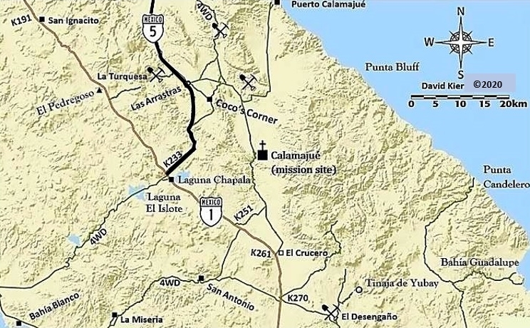
Is it generally quicker to go the san Felipe route to BOLA vs the Ensenada route? It seems like less than a year ago I went by Cocos and it was still
dirt/gravel. I could be mis-remembering though.
Is it generally quicker to go the san Felipe route to BOLA vs the Ensenada route? It seems like less than a year ago I went by Cocos and it was still
dirt/gravel. I could be mis-remembering though.
steve
The highway is completed from Puertecitos to Laguna Chapala. Coco's Corner is bypassed.