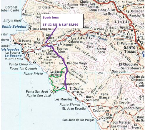
Is there someone here with knowledge of the road highlighted in purple on the attached map? It's been more than a dozen years since we've driven it.
We looked at it last year and the 'start' of the route nearest La Bocana was quite overgrown and we didn't give it a try - didn't want to delay our
trip with a dead end or closed route.
Thank you
John M
David K - 11-20-2020 at 05:58 PM
DanO is the area expert...
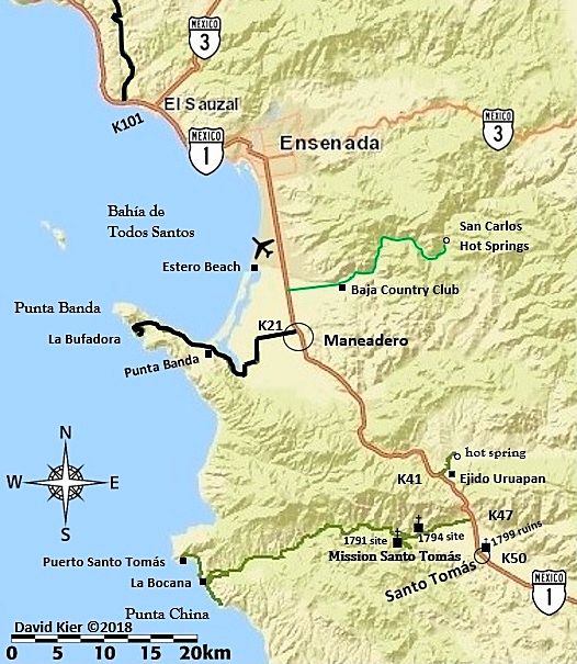
I recall it mentioned as best on a motorcycle? When I popped down that road, past the mission sites, for the road guide I did not see anything too
exciting looking going across the riverbed. Maybe check Google Earth and see if the image is recent?
This is all I put on my map for the region:
TMW - 11-21-2020 at 12:38 AM
Tim Morton told me a couple of years back he has ridden it. I'm not sure if he has done so recently but I'll ask.bajatrailrider - 11-21-2020 at 09:19 AM
that is my back yard ride it all the time. what exactly do you want to do John .
Confirmation that it is a through route
John M - 11-21-2020 at 01:37 PM
We wanted to take it from the La Bocana road to the light house at San Jose, then south to Erendira - the very first part of the road as we went south
looked very lightly traveled, if at all, and pretty overgrown - Just wanted to be as certain as we could that we could get through to Punta San Jose.
Thanks for your expertise.
John Mbajatrailrider - 11-21-2020 at 04:28 PM
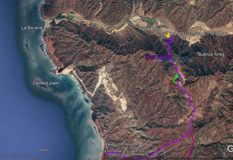
The big cement plant has extended there mining south of plant . Blocked most of the roads going south . we got past on motos I did not see a 4 wheel
route. As of one month ago one was chained other three tractor holes
Bajatrailrider - clarify
John M - 11-21-2020 at 10:12 PM
You said the cement plant has extended south. We would be several miles inland but have 4x4s not bikes. Our route is in purple.
John Mbajatrailrider - 11-21-2020 at 11:01 PM
John are you passing the small store . next to beach not always open much. then crossing small beach. Then south up hill . That is the area I believe
has closed roads.
Bajatrailrider -
John M - 11-22-2020 at 06:28 AM
No, we are not near the ocean, or the little store, not near the cement plant.
We will turn when we are 4 miles inland before we get to the beach.
John
bajatrailrider - 11-22-2020 at 08:21 AM
ok I think I know where you are. Do you go up a very steep winding dirt road. At top it goes East then south on RT the only rancho. There with
caretaker that route open great run. David K - 11-22-2020 at 08:37 AM
This is fun! bajatrailrider - 11-22-2020 at 08:57 AM
David I have every route stored in my head. Dam if I can follow purple lines
trailrider
John M - 11-22-2020 at 09:39 AM
Yes, a dirt road that is steep and winding - oh, maybe I better change colors from purple to what? White?
Or a better map - or no map - or one of David's maps
Yes the road goes south then west after maybe 6 or 7 miles comes to the lighthouse.
John
[Edited on 11-22-2020 by John M]satmike - 11-22-2020 at 09:43 AM
But Larry do we have to worry about your head getting old
We are not going to San Carlos this winter. Big lobster wars going on, permit holder killed by cartel. Some time in Arizona and hope to come see you
at some point.
Later MikeDavid K - 11-22-2020 at 10:07 AM
But Larry do we have to worry about your head getting old
We are not going to San Carlos this winter. Big lobster wars going on, permit holder killed by cartel. Some time in Arizona and hope to come see you
at some point.
Later Mike
Hi Mike...
Is Kevin keeping the place open through all this stuff?satmike - 11-22-2020 at 11:41 AM
He was shut down all year because of the virus, but plans on continuing if things are better next yearbajatrailrider - 11-22-2020 at 04:33 PM
yes sat Mike let's ride David K - 11-22-2020 at 04:36 PM
He was shut down all year because of the virus, but plans on continuing if things are better next year
Thank you,
That is good news!
We may need some more Baja Fogs, some day! www.solosports.net
[Edited on 11-23-2020 by David K]bajatrailrider - 11-22-2020 at 04:44 PM
haha funny John I see mountains with purple line . So since the winding dirt road goes to . The only rancho up there good route
.When are you doing the 4x4 run. DanO - 11-23-2020 at 09:42 PM
I haven't taken that route in a few years. Last time it was a fun ride on bikes. If not on bikes would definitely not attempt w/o 4WD, good
clearance, and a shovel. Sinkholes, washouts, steep and rocky ascents and descents, silt, etc. If you go, please post a report. Buena suerte.
[Edited on 11-24-2020 by DanO]bajatrailrider - 11-23-2020 at 09:55 PM
two months ago old beat up small toyota car. four Mexican fishermen on steep up hill. We where behind them on motos. It did get stuck in a rut.
Three jumped out pushing it got going driver. Had it pegged to the top the three guys walked . To the top away they went again. DanO - 11-23-2020 at 10:07 PM
Sounds like Baja poker. 4 fishermen in a Toyota beat 1 Nomad w/4WD and a shovel.
[Edited on 11-24-2020 by DanO]DosMars - 11-23-2020 at 10:38 PM
Any info on the road up and over from the port at Santo Tomas North over to the other side? Last time I was there there was a closed gate. Beautiful
coastline on the other side, plus some indian debitage I'd like to show the kids some day.
I left it where I found it, you could see where the indian was sitting flaking off stones from the core. You could put that rock back together like
a 3-d jigsaw puzzle... DosMars - 11-23-2020 at 10:54 PM