BajaNomad

Abandoned mine

nbentley1 - 7-20-2021 at 09:43 AM

We recently took the less traveled road from Punta Santa Maria (Seven Sisters area) to meet mex 1 south of Laguna Chapala. About 15 miles from the main road we stumbled upon an oasis. Once we hiked out to it we found an old adobe structure, non native trees and what appeared to be an abandoned mine. Anyone know the story of this place? thanks

Mine1.jpeg - 81kB mine2.jpeg - 66kB Mine3.jpeg - 324kB Mine4.jpeg - 96kB

JZ - 7-20-2021 at 10:54 AM

Not sure I'd open that up to see what is down there.


AKgringo - 7-20-2021 at 11:04 AM

To me it looks more like they wanted a well, or cistern for a ranch. Perhaps the original excavation was to create the adobe for the structure?

StuckSucks - 7-20-2021 at 11:11 AM

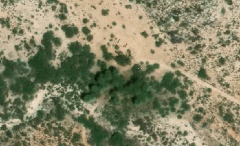
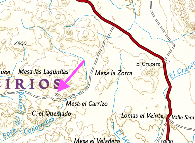
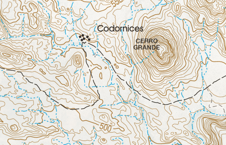
Looked around your location, which is only ~5 miles from the highway and found nothing. At 9.8 miles from the highway I found a bunch of trees (oasis?), and can see what appears to be an adobe structure at a place named Codornices. Could the "mine" have been a water well?


nbentley1 - 7-20-2021 at 11:22 AM

The hole was filled in, but you could see support beams that made it look like a mine structure. Don't know for sure, but it was a cool find.

nbentley1 - 7-20-2021 at 11:24 AM

StuckSucks, that for sure looks like the spot.

mtgoat666 - 7-20-2021 at 12:15 PM

That pic looks like hand-dug well. If it was a mine shaft, you would see other excavations around area (prospects, other s shafts or adits, etc), and see waste rock piles.

Hand dug wells often have timber on side walls, so hole does not collapse.

nbentley1 - 7-20-2021 at 12:19 PM

Quote: Originally posted by mtgoat666  
That pic looks like hand-dug well. If it was a mine shaft, you would see other excavations around area (prospects, other s shafts or adits, etc), and see waste rock piles.

Hand dug wells often have timber on side walls, so hole does not collapse.


Good point, well it is then

TW may know

John M - 7-20-2021 at 12:23 PM

He and I drove past that place a couple of years ago and I think at the time he knew something about it. Now, I'll email him and ask him to comment.

Hope he remembers.

John M

David K - 7-20-2021 at 12:28 PM

When I drove by in 2017, I came from Km. 270.5. there was an abandoned or unoccupied ranch 1.2 miles west of the junction with the Km. 252 road. I think that was the place pictured at the top?
https://caltopo.com/l/CLEJ

0.8 mile past the adobe was old Rancho Codornices/ San Antonio. That is where an oasis is, lots of trees.
https://caltopo.com/l/E98A

[Edited on 7-21-2021 by David K]

TMW - 7-20-2021 at 12:29 PM

Just before the jct where the road from Hwy 1 KM270 comes in there is a white house to the north on a hill. A rancher lives there or use to. I met him several years ago. Next time in the area you could ask him about the place you found.

The place above that StuckSucks has an arrow is an abandoned ranch. It has a well and there are many palm trees. Someone set them on fire several years ago. Also some one put up a fence and made a detour to avoid the place. There is another ranch close by to the east that is abandoned. People have lived there on and off over the years.

David K - 7-20-2021 at 12:34 PM

Exactly, we posted the same time, TW.
I also took the detour that bypassed old San Antonio/ Codornices. I wanted to have a closer look but didn't turn back... https://caltopo.com/l/KST0

Rancho La Miseria would change everything, a few miles further, down the mountain slope! https://caltopo.com/l/AVU5

[Edited on 7-21-2021 by David K]

TMW - 7-20-2021 at 12:37 PM

As I remember Rancho Codornices/San Antonio there was two buildings and they were near several palm trees. The building shown by nbentley1 is not it.

David K - 7-20-2021 at 12:41 PM

Quote: Originally posted by TMW  
As I remember Rancho Codornices/San Antonio there was two buildings and they were near several palm trees. The building shown by nbentley1 is not it.


I think so, as mentioned, they were nearly a mile apart.

I have had to tell people who thought San Antonio was a mission site, it was only an old ranch site.

PaulW - 7-20-2021 at 09:08 PM

Rancho Codornices
Been there twice TMW has teh exact identification. We drove both roads to that abandoned rancho.
Cistern or well is pictured. I think cistern was filled for the abandoned stream to the south. Usually these old ranchos do not have a mine. No evidence of tailings should prove that.
Several nearby structures that are dissolving into the earth are can still be detected.
That big tree is really a great specimen.

David K - 7-21-2021 at 07:15 AM

Quote: Originally posted by Lance S.  
Quote: Originally posted by David K  
Quote: Originally posted by TMW  
As I remember Rancho Codornices/San Antonio there was two buildings and they were near several palm trees. The building shown by nbentley1 is not it.


I think so, as mentioned, they were nearly a mile apart.

I have had to tell people who thought San Antonio was a mission site, it was only an old ranch site.


David probably already knows this but in case anyone else is interested... The location of the old Rancho Codornices was considered for a mission Cabacera. This was after they had pretty much decided on the site at Calamajue. The Jesuits called it La Hermosura, The Cochimi called it Keda. They were thinking that if Laguna Chapala had water they could use the two locations together for a mission based on raising cattle but with little or no agriculture. I don't know why they thought Chapala would have water the second time visiting it, they had been there the year before in 1766. Shows how desperate they were to find a site between San Borja and San Fernando.
The lower end of Arroyo San Jose (near Faro San Jose) was also considered.


Interesting!

Mission San Borja was opened in 1762. It was a visita of Mission Santa Gertrudis since 1759. The Jesuit in charge at San Borja was Wenceslaus Linck. In February (to April) 1766, Linck led a major expedition to seek out new mission sites and find a route to the Colorado River (also to again prove California was not an island).

It was Linck, during this expedition, who discovered Velicatá (the future site of Mission San Fernando). Velicatá was an excellent location for a mission, but being so far from San Borja, an intermediate mission was established first. This would be at Calamajué in October 1766 with its abundant (but salty) year-round stream. Crops failed and the water was undrinkable. In May 1767, the mission was moved and now identified as Mission Santa María de los Angeles.

Before the Jesuits could establish the mission at Velicatá, they were all removed and sent back to Europe under false pretenses.
Velicatá would become a mission during the Franciscan period, in 1769. It was the first California mission founded by Junípero Serra, in fact (not San Diego).

Map (south half) of Padre Wenceslaus Linck's 1766 expedition from San Borja (showing Keda and Codornices in close proximity):


Question: Lance, where did you read about La Hermosura?

4x4abc - 7-21-2021 at 09:07 AM

at least Laguna Chapala is in the wrong place on this map

David K - 7-21-2021 at 11:39 AM

Quote: Originally posted by 4x4abc  
at least Laguna Chapala is in the wrong place on this map


Several points are off, including San Ignacio (today's Rancho San Ignacito, between San Borja and Rosarito). Yubay as well, plus there's two of them!
San Borja and Calamajué are off, too.
The map is valuable only as showing the progress of Linck on each day and the Native place names.


[Edited on 7-21-2021 by David K]

4x4abc - 7-21-2021 at 05:04 PM

what would Las Palomas translate to on today's map?

4x4abc - 7-21-2021 at 05:22 PM

is there a published log of Linck's journey?

David K - 7-21-2021 at 06:28 PM

Quote: Originally posted by 4x4abc  
what would Las Palomas translate to on today's map?


Again, poorly located, in reality is just, or was just, a few miles westward of La Miseria.

David K - 7-21-2021 at 06:30 PM

Quote: Originally posted by 4x4abc  
is there a published log of Linck's journey?


Yes, the entire expedition diary of Padre Linck is published in English. It is Volume #5 of the Dawson Book Shop, Baja California Traveler Series.

4x4abc - 7-21-2021 at 07:02 PM

any online source?

David K - 7-21-2021 at 09:55 PM

Thank you, Lance... I will study these!

Figuring out the places

PaulW - 7-21-2021 at 10:51 PM

Let me clarify the rancho and San Antonio
The Rancho known as Condornices (ranch not shown on the Almac or the Atlas). And this ranch does not appear on Google earth.
The place nbentley1 found was San Antonio (AB) a small rancho on the road between the west coast north to Highway 1 at K257. This place is north of the new rancho discussed below.
The Almac shows a place called Condornices, but that label is west of the present functional rancho.

In the image below shows the existing roads with a loop to Antonio and back to the main road.

San  Antonio.jpg - 75kB

In this image I show the Cal Topo version with an old version of the road. The road shown was very overgrown on my first trip, but now that left side of the loop is an easy drive.


Cal Topo image.jpg - 204kB

Next is a screen shot from my GPS showing the old version like Cal Topo


IMG_1300.jpg - 82kB

The next image shows the roads near Rancho Condornices. The GPS call that place “San Antonio”. I put “Rancho Condornices” label there.


Rancho Cord.jpg - 131kB

4x4abc - 7-21-2021 at 11:08 PM

so, which location is Keda/La Hermosura - 1 or 2?
1 - 29°11'43.62"N, 114°19'1.05"W
2 - 29°11'15.69"N, 114°17'51.46"W

nbentley1 - 7-22-2021 at 09:38 AM

Quote: Originally posted by PaulW  
Let me clarify the rancho and San Antonio
The Rancho known as Condornices (ranch not shown on the Almac or the Atlas). And this ranch does not appear on Google earth.
The place nbentley1 found was San Antonio (AB) a small rancho on the road between the west coast north to Highway 1 at K257. This place is north of the new rancho discussed below.
The Almac shows a place called Condornices, but that label is west of the present functional rancho.

In the image below shows the existing roads with a loop to Antonio and back to the main road.

In this image I show the Cal Topo version with an old version of the road. The road shown was very overgrown on my first trip, but now that left side of the loop is an easy drive.


Next is a screen shot from my GPS showing the old version like Cal Topo


The next image shows the roads near Rancho Condornices. The GPS call that place “San Antonio”. I put “Rancho Condornices” label there.


Just to confirm this, here are my GPS tracks from the trip

Map3.png - 275kB

David K - 7-22-2021 at 09:43 AM

Historic Rancho Codornices and San Antonio are the same ranch.
Harald, I will need to get on my PC to see where your waypoints are, heading to the beach soon!

bajaric - 7-22-2021 at 09:45 AM

Some maps call the abandoned rancho at the apex of that little bend in the road Rancho San Antonio, some call it Rancho Las Codornices. The 2009 BCA calls it both names. Same place, two names. A different place called Cordornices is shown on the Baja California Almanac by a cross symbol but it is about ten miles west of the area in question.

As noted, there are some modern ranchos in the area that may be periodically occupied. The old well at San Antonio/Codornices was probably hand dug and went dry. It has been said that this general area has the least rainfall of anywhere in Baja. Its too far south to get the northern cold fronts in the winter, and too far north to get the tropical moisture in the summer.

If the missionaries were having such a hard time locating a mission in this general area I wonder why they did not pick Catavina, which seems to have plenty of water, or nearby Santa Ynez, instead picking Santa Maria where there was virtually no arable land for crops or grazing.

edit:

To answer my own question after thinking about it, the main diet of the indigenous in that area was sea food (turtles and scallops), so they might have wanted to locate the mission close enough to the Sea to enable the Indians to forage for wild food if needed, as was common in the missionary period.


[Edited on 7-22-2021 by bajaric]

Baja Topographic Atlas Directory

John M - 7-22-2021 at 10:43 AM

Shows both names, same place


page B93 - scan is a little blurry eh?

The "Directory" also shows Codornices 10 miles or so west - with a slightly different spelling, leaving out the first "r"

John

4x4abc - 7-22-2021 at 10:53 AM

Quote: Originally posted by Lance S.  
Quote: Originally posted by 4x4abc  
so, which location is Keda/La Hermosura - 1 or 2?
1 - 29°11'43.62"N, 114°19'1.05"W
2 - 29°11'15.69"N, 114°17'51.46"W


Maybe david can show the location of the old rancho codornices. La Hermosura was at or near there I believe. It took Linck half an hour to reach it from aqua leon.


cool! But where is Agua Leon?

4x4abc - 7-22-2021 at 11:07 AM

there are 6 ranchos in the vicinity
please fill in the names


Screen Shot 2021-07-22 at 12.04.23 PM copy 2.jpg - 301kB

4x4abc - 7-22-2021 at 11:12 AM

here is what's in the INEGI database (last census)

Screen Shot 2021-07-22 at 12.10.42 PM copy.jpg - 312kB

TMW - 7-22-2021 at 01:55 PM

The rancher that lives at the 4th pin from the left also owns the pin labeled El Sauce if that is the only ranch in that location. He told me he owned a ranch further to the west.

Also nbentley1's GPS reading show him near or at Ranch San Antonio/Codornices but his pictures don't look nothing like what I saw when I was there. Of course it's been several years since I was at the site. I remember lots of palm trees and no tree like his picture shows.

But I'm getting old so who knows. John M and I will have to make another trip down there to clear everything up.

PaulW - 7-22-2021 at 03:23 PM

Hi Harald,
What is the source of the image? It shows faint green lines that must be roads or trails that are very interesting. And the more prominent roads do not look familiar.

Quote: Originally posted by 4x4abc  
here is what's in the INEGI database (last census)


David K - 7-22-2021 at 04:41 PM

The last image Harald posted (last census) what is ladled Los Codornices is not the old ranch site in the palm tree oasis (which is the left pin).

Harald, we had threads about Agua Leon and Leon Grande... Both are between Punta Prieta and Los Codornices (San Antonio). They were important gold mining/ water supply points mentioned in the book, 'Long Walk to Mulegé' (a book from 1980 about a 1921 walking trip from San Diego by a pair of World War I vets).

Harald, you even made a map with both Leons on it...

Grande.jpg - 236kB

David K - 7-22-2021 at 05:09 PM

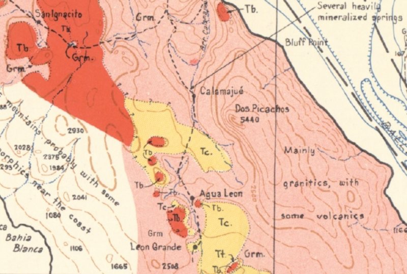
On the 1971 Geology Map:

Los Cordonices [sic] is at the very top edge.
Punta Prieta is at the loser edge.
Leon Grande is midway between the two.


=====================================================================


On the 1948 Geology Map:

Leon Grande and Agua Leon are both shown.


===========================================================================


On the 1918 Goldbaum Map (1925 printing):

Chapala is at the top.
Codornices is below.
Agua Leon is next.
Leon Grande is at the bottom.


*It was Goldbaum's map that the guys in a 'Long Walk to Mulegé' used to navigate!

4x4abc - 7-22-2021 at 05:57 PM

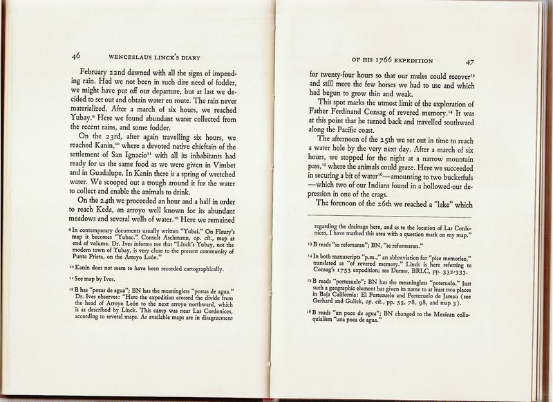
so, Keda is Codornices
where and what is Kanin?
Is Agua Leon Kanin?

4x4abc - 7-22-2021 at 09:59 PM

Quote: Originally posted by PaulW  
Hi Harald,
What is the source of the image? It shows faint green lines that must be roads or trails that are very interesting. And the more prominent roads do not look familiar.

Quote: Originally posted by 4x4abc  
here is what's in the INEGI database (last census)


I created a digital Baja Almanac (almost finished).
It has anything that has been driven (yellow or black) or walked (green) in it
Started 7 years ago with the idea to record Camino real - make it visible
In the process I recorded everything else that is visible from space
found airstrips in wow places - about 600

4x4abc - 7-22-2021 at 10:06 PM

Quote: Originally posted by Lance S.  
Quote: Originally posted by 4x4abc  
so, Keda is Codornices
where and what is Kanin?
Is Agua Leon Kanin?


Aqua Leon is Kanin. Linck stopped there on the way from Yubay to Keda.


on his trip north or south?

4x4abc - 7-22-2021 at 10:19 PM

so,
we have:

El Sauce
San Antonio - Codornices (A)
Codornices Nuevo (B)
Agua de Leon - Keda (C)
Kanin (?)
Mina Leon Grande (X)
Mina s/n (Y)

NE of B is where Don Jose Cota (the owner of much of the area) lives?

does anyone have a name for the ranch site (has Corral and Pila) NE of Don Jose Cota's place? The northern most pin

Screen Shot 2021-07-22 at 7.06.03 PM copy.jpg - 299kB

David K - 7-23-2021 at 10:02 AM

Harald, have you been to Agua Leon since we see now a road goes to it? I don't recall seeing it when I was going west from the highway. The incident at La Miseria was the overriding memory of that day!

4x4abc - 7-23-2021 at 11:29 AM

have not been to Agua Leon
yes, road is new
recent ranching activities

David K - 7-23-2021 at 06:49 PM

I will scan Linck's diary of those days! Check back tomorrow!

4x4abc - 7-23-2021 at 07:07 PM

Quote: Originally posted by Lance S.  


North. Six hours from Yubay to Kanin. One and one half hours from Kanin to Keda.


now we have to find that other Yubay

4x4abc - 7-24-2021 at 02:16 AM

using this for now
it reinforces that there was indeed another Yubai
see footnote 51

https://ia801304.us.archive.org/2/items/ELVIAJEDEWENCESLAOLI...

[Edited on 7-24-2021 by BajaNomad]

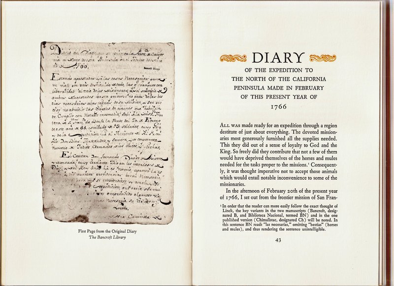
Linck's Diary from the 1766 Expedition, in English

David K - 7-24-2021 at 09:33 AM

The 1766 Expedition diary was translated by Ernest J. Burrus, S.J. and published in 1966.

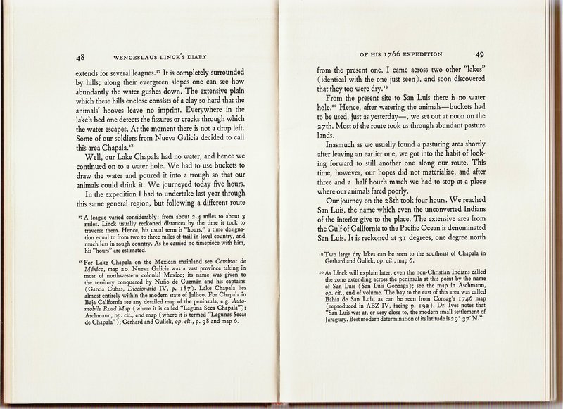
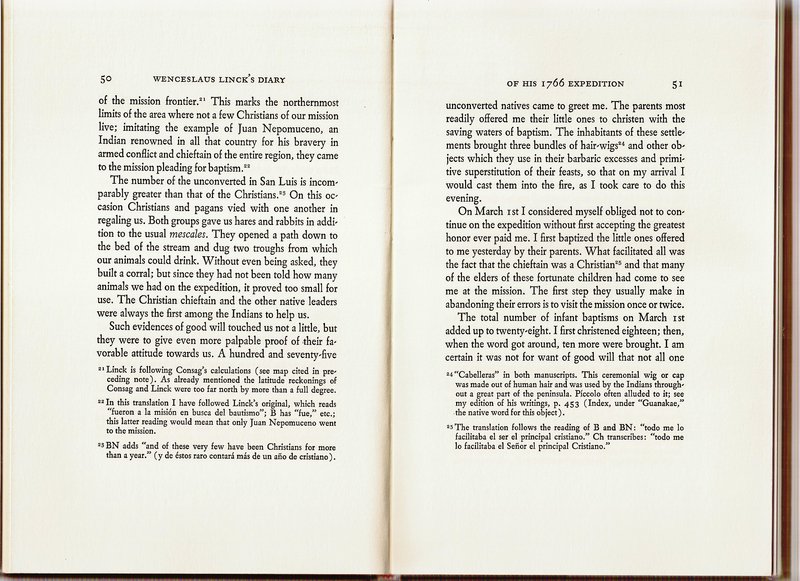
I will post the first few pages of the expedition diary and the map covering those days. These cover the sites of Kanin, Keda, Laguna Chapala, and San Luis:


['San Ignacio' (mentioned above) is not the mission to the south but here was a visita of Mission San Borja and today is Rancho San Ignacito.]

*Addition pages and the rest of the map available, upon request.

4x4abc - 7-24-2021 at 04:43 PM

thanks David.

What always amazes me reading the old trip logs - these guys were tough as nails.
Linck's first day
33 Kilometers (21 miles) in 4 hours?
without a well maintained trail/road?
WOW!

Kanin to Keda (7.5 km as the crow flies) in one hour.
Wow again.

Screen Shot 2021-07-24 at 5.43.17 PM.png - 28kB

David K - 7-24-2021 at 05:29 PM

How accurate were the times, I wonder? They didn't have watches or gps! Sun position, I guess? However, they often began well before dawn.

David K - 7-24-2021 at 06:08 PM

Quote: Originally posted by Lance S.  
Quote: Originally posted by 4x4abc  
Quote: Originally posted by Lance S.  


North. Six hours from Yubay to Kanin. One and one half hours from Kanin to Keda.


now we have to find that other Yubay


Well, I don't believe there is another Yubay.
While at Keda Linck mentions that it is the northern most point reached by the earlier Consag expedition. Apparently because of this, Dr. Ives, on who's opinion the map is based, assumed that Linck followed Consag's route up to Keda. This is what we get on the map. It was also a route Ives could follow in a car. This was in the 50's or 60's (?). In order to make that route work Ives decides that there must be another place called Yubay north east of Punta Prieta. He does not know where it is but it must be there or his proposed route doesn't work.

Today with google earth and the baja almanac I think a strong argument can be made that Yubay was Yubay. It's pretty clear based on the times traveled between points and the site descriptions.

Should probably start another thread.


The Dr. Ronald Ives-made map could be revised with our improved details and maps! In the diary, many footnotes are conversations with Dr. Ives on the place names and routes, two places called Yubay, etc.

4x4abc - 7-25-2021 at 01:46 AM

Quote: Originally posted by Lance S.  
Quote: Originally posted by 4x4abc  
any online source?


La Primera Entrada , Carlos Lazcano Sahagun (2000) contains the Spanish text of the expedition. Maybe David can ask if it is available online. He posted a link to Sahaguns publication of the Consag diary.


which page?
I have the book, but can't find the Linck diary

4x4abc - 7-25-2021 at 07:37 AM

my bad - I have the "Vestigios" book

David K - 7-25-2021 at 10:13 AM

Ives shows Linck going west, then north... and incorrectly locates San Ignacio (Ignacito) to the north, as it was not visited by Linck.

Lance has solved the confusion by showing Linck going north, then west. Linck did not see San Ignacio (Ignacito) because it is to the west of San Borja, and he went north!

On the 1962 Gulick map, it is easy to see all the points except Agua Leon:


[Edited on 7-25-2021 by David K]

4x4abc - 7-25-2021 at 10:25 AM

what I have so far
found most of the trail between San Ignacio and Las Cuevitas
found most of the trail between Codornices and Laguna Chapala
located the mountain pass mentioned
found all the water sources

Screen Shot 2021-07-25 at 11.20.56 AM copy.jpg - 301kB

David K - 7-25-2021 at 11:19 AM

See Lance's post above mine. San José de Vimbet is Agua Amarga, then the one and only Yubay was next. ??

4x4abc - 7-25-2021 at 11:48 AM

there is more than one place with bitter water
it is established that Vimbet is La Bachata

PaulW - 7-25-2021 at 12:20 PM

My GPS map has always shown Yubay in large text. I assumed the label represented a general arena near Coco including the mountains east of Hwy5

David K - 7-25-2021 at 01:18 PM

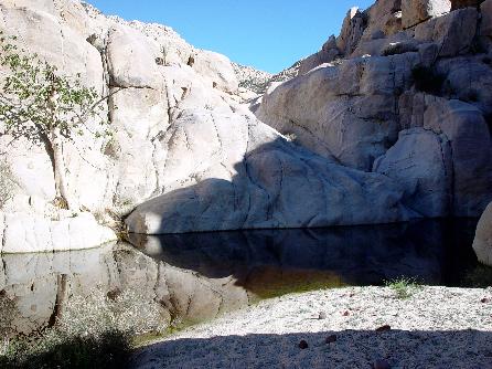
Yubay is a tinaja up in a granite walled canyon, about a kilometer off the main El Camino Real route.

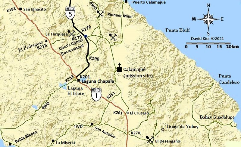
Here it is, on my map:


Access from El Desengaño.


Trail to Yubay, which is straight ahead.

Standing on the boulder ledge, above the water hole...

Tinaja de Yubay in July 2001 (low water level).
GPS: N29°10.69' W113°59.26' (WGS 84) elev. 2,059'

Neal Johns has some good photos when it was overfilled with water in Feb. 2003:


Note the fig tree on the rock to the left. That is what tells you that you have found the true Yubay!

David K - 7-25-2021 at 05:58 PM

The region is Yubay, and the waterhole is the Tinaja de Yubay. On maps you will see arroyos named Yubay, etc. On older maps, there are spelling variations.

4x4abc - 7-25-2021 at 09:19 PM

IF they had taken the route north to Agua Amarga (close to Agua Higuera negating the comment that there is no water near Vimbet) then San Ignacio would have been to the west
there is no (meager) grass between San Borja and Agua Amarga
there is not even a glimpse of water anywhere
Agua Amarga has absolutely no grass
La Bachata does - water at La Bachata is bitter (agua amarga)
the terrain between Borja and Agua Amarga is very challenging
I doubt they could have done it in 7.5 hours
the terrain between San Borja and the disputed Yubay is easy
it has a well pronounced trail that is still visible today

IF they had taken the route to Agua Amarga and then to the known Yubay since the goal was to travel far north, it would have made more sense to continue to Calamajue with known water sources on the way
but Linck had explored that route already the year before
the known Yubay has no grass
the disputed Yubay does
traveling west from the known Yubay to Kanin is a much tougher route than from the disputed Yubay to Kanin

I suspect San Ignacio is not mentioned because it is so close to San Borja that it had no impact on the travel that day


[Edited on 7-26-2021 by 4x4abc]

Screen Shot 2021-07-26 at 10.37.42 AM copy.jpg - 300kB

[Edited on 7-26-2021 by 4x4abc]

4x4abc - 7-26-2021 at 09:55 AM

all known water sources in the area


Screen Shot 2021-07-26 at 10.52.04 AM copy.jpg - 282kB

David K - 7-27-2021 at 06:01 AM

Interesting water source data base, Harald. What is the source of your intel on them?

John Harper - 7-27-2021 at 07:26 AM

Yes, that's pretty amazing how many sources. I assume many are non-potable, mineral springs?

John

4x4abc - 7-27-2021 at 08:00 AM

a good number is sweet and in reach
most are good water but tucked away
many are inconsistent
some will help you survive but are not pleasant

I created the data for the water sources
the majority is from sat images

Baja actually has a lot of water sources
but as the Jesuits already noticed, they are rarely in places where you could use the water

Screen Shot 2021-07-27 at 8.57.54 AM copy.jpg - 307kB

David K - 7-27-2021 at 08:15 AM

Can you show us the San Felipe to Laguna Chapala region sources?

4x4abc - 7-27-2021 at 08:43 AM

still working on San Pedro Martir
but this is what I have so far

Screen Shot 2021-07-27 at 9.40.51 AM copy.jpg - 312kB

4x4abc - 7-27-2021 at 08:47 AM

.

Screen Shot 2021-07-27 at 9.44.23 AM copy 2.jpg - 291kB

John Harper - 7-27-2021 at 09:12 AM

Wow, that's incredible.

John

David K - 7-27-2021 at 09:24 AM

Please add the area from Matomí to Chapala, if you can.
I guess the marker north of Matomí is Nuevo Mazatlan (Agua de Chale well), but what is the other one just west?

4x4abc - 7-27-2021 at 10:46 AM

image above San Felipe area

Don Jorge - 7-27-2021 at 11:21 AM

Quote: Originally posted by 4x4abc  
a good number is sweet and in reach
most are good water but tucked away
many are inconsistent
some will help you survive but are not pleasant

I created the data for the water sources
the majority is from sat images

Baja actually has a lot of water sources
but as the Jesuits already noticed, they are rarely in places where you could use the water


Wow! That is so interesting and absolutely one of the best "maps" ever shared here! Thanks for both taking the time to collect the data and share it.

4x4abc - 7-27-2021 at 11:45 AM

working on this project for many years
now looking for a way to make it available to people who need all the exotic stuff i have recorded
can't be open source (gpx or kmz) - need to buy food and beer sometimes

I have everything anyone would ever need

property markers
rodeo
horse races
ship wrecks
railroads & tramways
pilas
beautiful spots
beaches
bays
Puntas
ruins
lighthouses
chapels
memorials/graves
missions
toll booths
hot springs
cementerios
mountains
lomas
sierras
llanos
lagunas
esteros
dunes
settlements
bridges
MC trails
MTB trails
whale watch locations
ranchos
corrales
springs
canyons
arroyos
palmas
cell towers
old map places
all topo sheet numbers
cuestas
piers
volcanos
US war installations
RV places
gas stations
LPG stations
e-charge stations
some bars
some hotels
air signs
airstrips
airports
mid air airplanes
some ATM
Mexican Flags
water treatment plants
solar plants
jesuit cal activities
benchmarks
campos touristicos
checkpoints
gates
CFE installations
gringo developments
fish camps
fields
ghost towns
missonary grape locations
islands
indian stuff
cave paintings
lagunas
km markers
mesas
mines
mission stuff
water works
dams
mysterious stuff
points of interest
prisons
propane
puertos
ruins
salinas
saltos
ship wrecks
slot canyons
structures
trash sites
valles
walls fences
fairy circles
historic 1970's
ranchos
airplane wrecks
casonas
chimneys
geoglyphs
mangroves
miradores
monuments
fish farms
shrimp farms

all roads
all 4x4 tracks
all mining trails
animal tracks
Camino Real
Pemex exploration tracks

4x4abc - 7-27-2021 at 12:19 PM

the beauty of this digital almanac is that everything is searchable (unlike the print/pdf versions)
you can add/remove any group from your display

searching for cemeteries in the El Triunfo-San Antonio area?
go to El Triunfo
select cemeteries
gives you location, name, size, orientation, possible comments

looking for the real Camino Real (not some scribble on a 1:100,000 map)?
I have it recorded
like the one between Londo/El Rosarito and Mulege
the original 1705 route

Don Pisto - 7-27-2021 at 12:46 PM

Quote: Originally posted by 4x4abc  
the beauty of this digital almanac is that everything is searchable (unlike the print/pdf versions)
you can add/remove any group from your display

searching for cemeteries in the El Triunfo-San Antonio area?
go to El Triunfo
select cemeteries
gives you location, name, size, orientation, possible comments

looking for the real Camino Real (not some scribble on a 1:100,000 map)?
I have it recorded
like the one between Londo/El Rosarito and Mulege
the original 1705 route

"I created the data for the water sources
the majority is from sat images".......I don't understand how does a satellite image know there's water there?

John Harper - 7-27-2021 at 01:05 PM

This is an amazing amount of work done by 4x4. Very impressive. Thank you so much for your efforts. I may never use it, but I sure appreciate the work involved to produce it.

John

4x4abc - 7-27-2021 at 01:39 PM

how do you spot water on sat images?
ocean is easy - right?
due to space reflection it almost always shows as black

Aguajes, Pozas, Tinajas are a bit more difficult to find
they are always in a canyon
they have animal tracks going to and from if the water is drinkable

like the Tinaja below
it is 90 ft in diameter
it shows strong trails
it has some human activity close (Corral)
you won't find it on any map
it is not mentioned anywhere

Screen Shot 2021-07-27 at 2.32.00 PM copy.jpg - 309kB

4x4abc - 7-27-2021 at 01:45 PM

another example
Arroyo La Palmilla (close to San Evaristo)
Aguajes (large Tinajas) show in black
the historical images in Google Earth allow an evaluation whether the water is temporary or permanent

Screen Shot 2021-07-27 at 2.42.03 PM copy.jpg - 314kB

4x4abc - 7-27-2021 at 01:53 PM

thanks to the hyper building activities in BCS the sat images are almost photo realistic
there is no way to mistake water for something else
below Arroyo Agua Caliente close to Santiago

unfortunately images on Nomad are always blurry
go see the real thing in Google Earth
stunning

Screen Shot 2021-07-27 at 2.47.58 PM copy.jpg - 317kB

4x4abc - 7-27-2021 at 07:13 PM

sorry for bombarding and overloading you guys.
I have learned so much the last few years that it sometimes has to come out.
I'll go back to the pool.

John Harper - 7-28-2021 at 05:18 AM

This has been a fascinating thread, extremely informative. Good work!

John

David K - 7-28-2021 at 09:30 AM

Thanks Harald.
More of that water source map would be nice to see if you have the energy!