This is my first post, so I thought I would make it about my Father in Law. In 1948 he and his brother on BSA motorcycles crossed the Peninsula from
San Quintin to San Felipe.
I don't know the exact route, but, neither did they, they used dry washes and burro trails.
When they got to San Felipe the townsfolk were so excited they gave them a parade and Fiesta.David K - 12-8-2021 at 09:21 AM
What a super story!
Indeed, in 1948 there was no road between San Felipe and Gonzaga Bay. Mountains and canyons between the two coasts of Baja make any direct route
unlikely. The San Matias Pass is the only corridor connecting the Pacific side with San Felipe... They must have... well, I just don't want to
guess...
Have any photos or other details?BajaBlanca - 12-8-2021 at 07:16 PM
Welcome to nomads and that is a GREAT first post! Wish there was a photo to go with it! Thanks for sharing and keep 'em coming. por favor!4x4abc - 12-8-2021 at 08:15 PM
WOW!freediverbrian - 12-8-2021 at 09:24 PM
I rode with a guy that had a BSA back in the 70s, I did not like riding behind him it felt like something was punching in my face. The exhaust off his
old four stroke was powerful. It took a big man to start that bike. JZ - 12-8-2021 at 10:30 PM
Can you guess the route they might have taken and show us?
4x4abc - 12-8-2021 at 11:37 PM
I have looked at lines straight across
crazy! CRAZY!
unless they swung north and did San Matias pass
that would be an easy routePerrro Viejo - 12-9-2021 at 06:19 PM
I don't know more than I mentioned. I got the story more or less third hand from my wife. She is sure he did a fairly straight line from San Quintin
to San Felipe, but unless they threw the bikes off cliffs on the east side I dunno. I crossed from San Jacinto to Lazaro Card##a and hit route three
down to Mex 5 on my Triumph Tiger last April, that was a fun ride, but not difficult. The dirt road from Mex 1 to Mex 3 is a great ride. My father in
law was an interesting guy, after the war he and his brother goofed off for a few years. They Rattlesnake hunted around San Quintin and took the
snakes to Loma Linda University for milking for antivenom. He raced bikes on the SoCal dry lakes, a sheet of plywood tied to the bike to lie on as
they did speed runs. 4x4abc - 12-9-2021 at 09:27 PM
IF the guys did not use San Matias pass, then there is only one choice to get through with a bike.
According to the 1949 map there was a road from San Quintin to El Rosarito
easy terrain from there to rancho Las Tinajas
there are animal trails going up to Mesa Las Tinajas
if a Mesa has a name then there is access to its top
(except Mesa La Sin Entrada)
then over to Mesa Pareja
down to rancho El Parral is tough - but there are trails
an alternative route would come through Mesa Matomi
much easier climb to Mesa Pareja
a new road has recently built going up to Mesa Pareja
could be the start to a San Felipe shortcut
exciting times
Attachment: bike.kmz (2kB) This file has been downloaded 276 times
Attachment: bike Matomi.kmz (1kB) This file has been downloaded 243 times
[Edited on 12-10-2021 by 4x4abc]Perrro Viejo - 12-10-2021 at 08:13 AM
4x4, thanks for that map. The San Quintin to Rosarito San Isidor to San Felipe may have worked!David K - 12-10-2021 at 08:54 AM
San Isidoro east is barely passable on foot and includes a steep switchback up a palisade before arriving at Mission San Pedro Mártir. The trail on
east was a foot trail that could get down to Agua Caliente Canyon. Baja Nomads backpacked from Santa Cruz to San Isidoro to the mission, and back...
in 2004. [Jack Swords, Mexitron, Pappy, Huddo, and the late Taco de Baja (Brooks Smith)]4x4abc - 12-10-2021 at 08:59 AM
4x4, thanks for that map. The San Quintin to Rosarito San Isidor to San Felipe may have worked!
no, not to San Isidoro!
That is rough country
the route I am proposing is pretty much east from El Rosarito
[Edited on 12-10-2021 by 4x4abc]Perrro Viejo - 12-10-2021 at 09:06 AM
thanks for the correction, it would be fun to get in there and poke around. See what is doable. I know much of the Eastern escarpment is steep.
I will also get around to correlating your map with All Trails top app. 4x4abc - 12-10-2021 at 09:16 AM
here is the access road to Mesa Matomi and Mesa Pareja
30°21'42.22"N, 115°10'40.15"Wpacificobob - 12-10-2021 at 09:39 AM
For me the most noteworthy element of this yarn is that the BSAs ran the entire way. Any idea of the model used?
These days we forget that moto's from that period just broke a lot.David K - 12-10-2021 at 09:46 AM
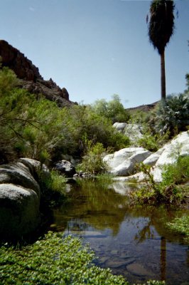
I have been to Rancho Parral (Parral Canyon)... No road beyond, no trail, palms, water, and boulders... But, I am hopeful there will be a way through
someday!
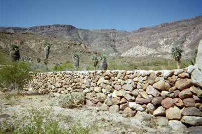
Rancho El Parral was abandoned in 2004 and the road there from Valle Chico/ San Felipe washed away a mile from the ranch.
These walls are visible on satellite images
Past the ranch is the beautiful view. BajaTed - 12-10-2021 at 09:54 AM
BSA pedigree I know of:
A BSA Thumper was the first bike to climb the "Matterhorn" @ Saddleback MC park back in the day. Gobs of Torque on those things was my memory. 4x4abc - 12-10-2021 at 10:12 AM
how about gas?
I calculated 110 milesPerrro Viejo - 12-11-2021 at 07:29 AM
Great comments! And I don't have the answers. Gene was a remarkable man, slight of build, his brother was huge, and got in trouble a lot and probably
saved Gene from trouble. Before the war Harold got put in Jail in Julian for traveling with an under age girl, the jail was an iron cage set on the
ground, his girlfriend borrowed a jack from a service station, jacked up a corner and they took off. Gene was a true renaissance man. He became a
surveyor and introduced aerial photogrammetry to civilian use. He and my mother in law took motorcycle trips on his BSA in the early 50s from
Bakersfield to camp in Death Valley where he had a gold mine (mostly an excuse to use dynamite) on his BSA.
He held a land speed record, for about 15 minutes on a modified BSA set on one of the dry lakes and raced flat track at Famoso, so, I know a lot about
him, but next to nothing about the trip across Baja. I did not know about the trip while he was alive, so I was unable to quiz him.WestyWanderer - 12-11-2021 at 08:56 AM
What an adventurous couple, thanks for sharing.
Something to think about.. We’re talking about over 50 years ago, things could have been much different i.e. areas that looks impassible now could
have been much different then.
[Edited on 12-11-2021 by WestyWanderer]mtgoat666 - 12-11-2021 at 09:06 AM
Dont apply facts and logic to a good story, just enjoy the story!PaulW - 12-12-2021 at 10:15 AM
I don’t ride a motor bike but from what I see on TV extreme sports I wonder if these guys were so good that one of the hike/walking trails across
the mountains would be doable on a motorcycle?Perrro Viejo - 12-12-2021 at 07:18 PM
Paul, likely burro pack trails along with dry washes. John Harper - 12-13-2021 at 09:11 AM
I don’t ride a motor bike but from what I see on TV extreme sports I wonder if these guys were so good that one of the hike/walking trails across
the mountains would be doable on a motorcycle?
Maybe someone on a trials bike? Hop from rock to rock.
JohnPerrro Viejo - 12-13-2021 at 10:16 AM
John, my father in law and his brother did it on 650 BSAs 73 years ago! 100X - 12-13-2021 at 10:31 AM
The locals here in Baja are very ingenious. If there is a reason to get somewhere, they will build a road, yesterday it was likely a trail. I do not
imagine a Baja local in the 1940's saying something is too hard for them to accomplish. I would have to imagine burro or walking trails existed and
the locals had knowledge of them.
A couple good riders on BSA 650's would be able to ride those trails I am sure. Gas I would think was also used at ranchos etc. in those days and
would be available. Even today, if you ask, you will receive knowledge and assistance no matter where you are on the peninsula. I do not doubt this
story in the least.4x4abc - 12-13-2021 at 11:50 AM
found a well defined trail up to Mesa Pareja from Rancho El Parral
2010 is the best Google Earth image for that
Attachment: Pareja trail.kmz (3kB) This file has been downloaded 242 times
[Edited on 12-13-2021 by 4x4abc]Perrro Viejo - 12-14-2021 at 04:31 PM
Wow, a great map! My wife is so pleased that you folks are so curious about the ride, she wishes her dad was still alive, he would love to tell you
about the trip.John Harper - 12-14-2021 at 04:51 PM
Wow, a great map! My wife is so pleased that you folks are so curious about the ride, she wishes her dad was still alive, he would love to tell you
about the trip.
Well, thank you for giving us something interesting to investigate!! Some of us actually love learning, exploring, and expanding our knowledge base.
JohnPerrro Viejo - 12-15-2021 at 01:04 PM
John, Baja is one of those great corners of the world. I reckon most Baja Nomads are as you describe.
A lot different than the people that fly into San Jose Del Cabo to play golf. 4x4abc - 12-15-2021 at 05:29 PM
according to Google that last section of the road on Mesa El Pareja was pushed in 2016 0r 2017
but it also means the terrain is fairly easyDavid K - 12-15-2021 at 06:39 PM
I see a long trail line on the left and a very short one on the right, two colors but I can't tell you what colors they are of if there is a third
color.
Green, magenta >??
Please have mercy on the color-blind, and use white, black, yellow, blue, or other 'bright' colors. Off-shades of red and green just blend together or
blend into the background earth colors to us making it hard to see or tell apart.
Thank you!4x4abc - 12-15-2021 at 06:42 PM
30% of the population is color blind - they will have a hard time detecting your lines
use white, yellow, green