BajaNomad

App For Navigation Through Mexicali?

DosMars - 1-4-2022 at 11:10 AM

My phone will store a route from the border heading south, but I can't get internet on the way home until I'm in line back at the border. Now that I have SENTRI I need an app that will help me navigate my way through the border towns directly to the right line.

What do people recommend?

JZ - 1-4-2022 at 11:29 AM

Google Maps lets you download an area for offline use.


Here's how you do it: https://support.google.com/maps/answer/6291838?hl=en&co=...


[Edited on 1-4-2022 by JZ]

DosMars - 1-4-2022 at 12:59 PM

Thank you JZ, I wish I'd have known about that sooner!

100X - 1-4-2022 at 01:59 PM

Also MapsMe or GAIA for offline. OnX also works offline (have to download the area map you are interested in), and has great satellite imaging. All are free or have free versions.

[Edited on 1-4-2022 by 100X]

mtgoat666 - 1-4-2022 at 02:19 PM

Quote: Originally posted by DosMars  
My phone will store a route from the border heading south, but I can't get internet on the way home until I'm in line back at the border. Now that I have SENTRI I need an app that will help me navigate my way through the border towns directly to the right line.

What do people recommend?


You remember how we used to navigate before the internet?
For traveling main roads, paper map always works. For last few streets right near border, just print out a GE map to take in car, or roll down your window and ask for directions.

If it has been a while since i have used a border xing, i always look online to see latest sentri route. The sentri line gets moved every few years… seems most all the border xings are in state of perpetual reconstruction…


PaulW - 1-5-2022 at 08:10 AM

Wing it from Hwy 5 west to the main drag to the Sentri street


Sentri.jpg - 208kB

DosMars - 1-5-2022 at 08:34 AM

Quote: Originally posted by mtgoat666  


You remember how we used to navigate before the internet?
For traveling main roads, paper map always works. For last few streets right near border, just print out a GE map to take in car, or roll down your window and ask for directions.

If it has been a while since i have used a border xing, i always look online to see latest sentri route. The sentri line gets moved every few years… seems most all the border xings are in state of perpetual reconstruction…


I too am a product of the Thomas Guide era! My problem is reading street names in Spanish on a map while looking for street names in Spanish on street signs that are not always visible while driving in a foreign city in traffic after a week on the beach after a long drive.

I want to rely on putting all my trust into this gadget that tells me where to go turn by turn with a nice display highlighting where I am and where I'm going. :spingrin:


AKgringo - 1-5-2022 at 08:53 AM

On my last three trips north through Mexicali west, finding my way to the end of the line was different than before. No matter what APP you find to get you there, it is a good chance that things have changed.

Detours are the nature of the beast!

PaulW - 1-5-2022 at 11:45 AM

True if you are a regular rather than Sentri one has to travel way west to find the nd of the line. Some backtracking is required.
For Sentri get to the main boulevard rather far south than my image shows.

pacificobob - 1-5-2022 at 12:58 PM

Quote: Originally posted by mtgoat666  
Quote: Originally posted by DosMars  
My phone will store a route from the border heading south, but I can't get internet on the way home until I'm in line back at the border. Now that I have SENTRI I need an app that will help me navigate my way through the border towns directly to the right line.

What do people recommend?


You remember how we used to navigate before the internet?
For traveling main roads, paper map always works. For last few streets right near border, just print out a GE map to take in car, or roll down your window and ask for directions.

If it has been a while since i have used a border xing, i always look online to see latest sentri route. The sentri line gets moved every few years… seems most all the border xings are in state of perpetual reconstruction…


Yes, I remember paper charts. I am a fan of having paper maps available as a backup.
I live aboard my boat in Alaska for a couple of months each year when the heat gets to me. paper charts are harder to find all the time. I can't imagine flying or boating without them as a backup when the fancy electronics go dark.

mtgoat666 - 1-5-2022 at 01:33 PM

Need map boy to post a new map of the new/latest routes to mexicali west sentri, ready and regular lanes....

i wish there was site that maintained up-to-date maps showing last mile for each border xing, each lane type...


[Edited on 1-5-2022 by mtgoat666]

JZ - 1-5-2022 at 01:40 PM

Google Maps will take you there. Just study it before reaching the city.

Paper maps are useless for driving in a city.


mtgoat666 - 1-5-2022 at 01:47 PM

Quote: Originally posted by JZ  
Google Maps will take you there. Just study it before reaching the city.

Paper maps are useless for driving in a city.


shorty mcjizz:
google maps does not give you choice to navigate by lane type (sentri, ready, regular), so not that useful...

JZ - 1-5-2022 at 02:03 PM

Quote: Originally posted by mtgoat666  


shorty mcjizz:
google maps does not give you choice to navigate by lane type (sentri, ready, regular), so not that useful...


Yeah it does, for sure. You just need to know how to use it, pal.

JZ - 1-5-2022 at 02:06 PM


JZ - 1-5-2022 at 02:14 PM

Mexicali


PaulW - 1-5-2022 at 04:01 PM

Using Google Maps
Accurate northbound crossing for Mexicali west
Sentri coming from the south on Hwy 5 turn left to get to Calz de los Presidentes
The last chance for that left is Calz James W Stone. Sooner is better.

Standard use the same route to the Sentri but pass it to the left and turn left and turn left on to Aguascalientes. Drive west a considerable distance west then U turn to International beside the new fence and go east. Follow that road to the cloverleaf to the border.

On the closeup see yellow for Sentri and Green for standard There is no Ready.
Sure enough the Google arrows seem to be confused.


Closeup.jpg - 217kB

west crossing.jpg - 247kB

BajaMama - 1-6-2022 at 07:26 PM

I'm an older woman and get a little frazzled driving through the border towns. I use GPS (I have an old Garmin but Google Maps or Waze work fine) but both times I crossed crapola happened. Anyhow, my point is, look at Google Maps and Google Earth so you have an idea of where you are going. I don't trust the GPS apps completely. Last time they tossed me into the middle of the SENTRI lane for Mexicali West and others were NOT happy with my "cutting" into line.

mtgoat666 - 1-6-2022 at 08:38 PM

Quote: Originally posted by PaulW  
Using Google Maps
Accurate northbound crossing for Mexicali west
Sentri coming from the south on Hwy 5 turn left to get to Calz de los Presidentes
The last chance for that left is Calz James W Stone. Sooner is better.

Standard use the same route to the Sentri but pass it to the left and turn left and turn left on to Aguascalientes. Drive west a considerable distance west then U turn to International beside the new fence and go east. Follow that road to the cloverleaf to the border.

On the closeup see yellow for Sentri and Green for standard There is no Ready.
Sure enough the Google arrows seem to be confused.


This web page says you can approach the Mexicali regular lanes from either west or east. Is that true? Which is fastest?
https://www.visitloreto.info/mexicali-border-crossing


[Edited on 1-7-2022 by mtgoat666]

[Edited on 1-7-2022 by BajaNomad]

bajaric - 1-7-2022 at 12:16 AM

Yes, true you can still approach from east, as of 2 months ago in November.

This is the "old way"; simply drive north on Hwy 5 until it goes no farther,
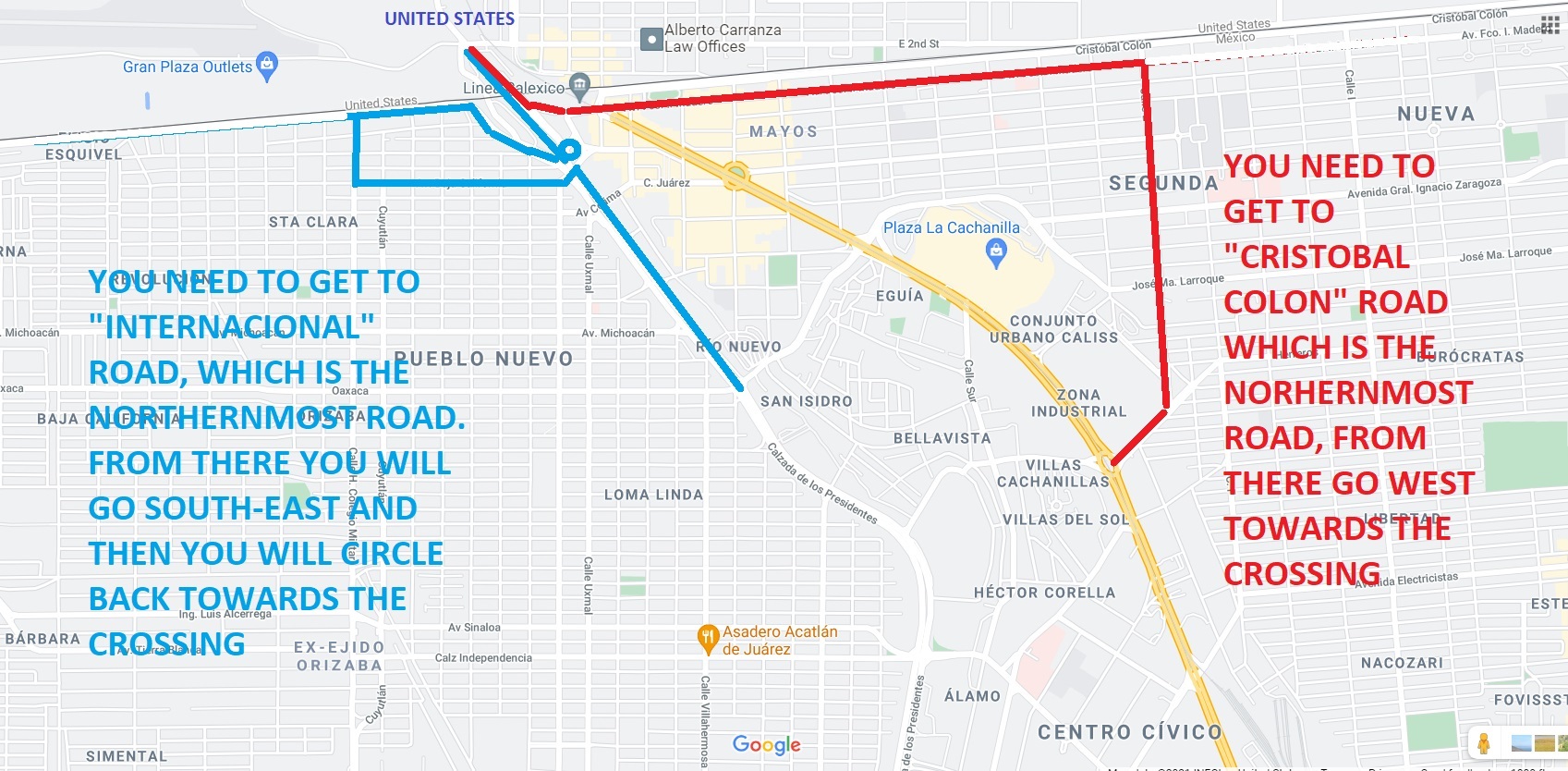
turn right, find end of line on Cristobal Colon, a one-way street westbound on border fence. New underpass leads to new gates a little west of the old
crossing. The red line on map above should be on Cristobal Colon, it is incorrect.

The cutoff shown by the red line above would probably be a little faster than going all the
way to the end of Hwy 5, but I am a creature of habit, that is how I always
do it.

What is new is that another line coming in from the west merges just before
the gates. Not sure if east or west approach is faster. Usually, a 1-2 hour
wait in the regular lanes at that crossing, probably not much difference.

[Edited on 1-7-2022 by bajaric]

BajaMama - 1-9-2022 at 10:54 AM

Discover Baja has directions to Mexicali East SENTRI lane that you can print.
https://www.discoverbaja.com/go/driving-directions/mexicali-...

Discover Baja route to east crossing

PaulW - 1-10-2022 at 10:46 AM

A mix of the old way past Costco and the latest way to the border from the east. The main issue is that route is for the standard lane and to enter sentri or ready one would have to drive west and make a U turn to get in line for a left turn into those lanes. It would be workable but because if the long line one has to driv pretty far to the U turn.

mtgoat666 - 1-10-2022 at 11:52 AM

so, on a typical day, is mexicali east or west fastest for northbound regular (or ready) lane when towing trailer?

[Edited on 1-10-2022 by mtgoat666]

PaulW - 1-10-2022 at 12:33 PM

Going North
After my west experience and standard I have not been back. To risky for me to try until I get better info for standard.

East Sentri seldom has significant lines. Ready sometimes has big lines, but sure moves good. Standard works ok, and I usually take a hour to cross.

As always timing is very important. The BP web site seems to be OK for choosing the time to cross.

Mexicali West Regular Lanes

chatolj - 1-10-2022 at 05:53 PM


This web page says you can approach the Mexicali regular lanes from either west or east. Is that true? Which is fastest?

We crossed yesterday and yes it is true. We got into the West side line which uses the circle bridge and the line was not moving much. The vendors told us minimum 1.5 hour wait there but less than 1/2 hour at the East Side line. So we got out of that line and went to the East side line.
Made it to the US inspection booth in 35 minutes.
35 Minutes on a Sunday afternoon.
West side looked to have one lane, East side line was feeding 4 lanes.
Also, the line was very orderly with no cutting / maneuvering.
That was my experience yesterday. Who knows next time. LOL