ztrab - 1-13-2022 at 05:22 PM
I've ridden just east a bit from the Pemex(Hwy3) at Ojos Negros south to Uruapan half a dozen times but not in the last 3 years. I thought I heard
that there were some locked gates? I also know there is a somewhat parallel trail off Hwy 3 further west, but I have never ridden it. Its pretty
much a sweeping graded road until it starts west into the hills, I don't remember any gates though they show two on most maps. I know there is a gat
at the ranch after(going west) the gnarly washed out descent, but it has never been locked in the 15 plus years I've been through it.
While I am asking, from the last gate on the 10 mile section from Mike's that goes to El Portrero - ejido Benito Juarez - Colonet, is that open as
well? If any one has a track they can share via email, much appreciated.
Any trail current info would be appreciated. Rode from Tecate to VT via the Goat Trail& Mike's to Meling last April, all good stuff.
I may have what you are asking
John M - 1-14-2022 at 05:00 PM
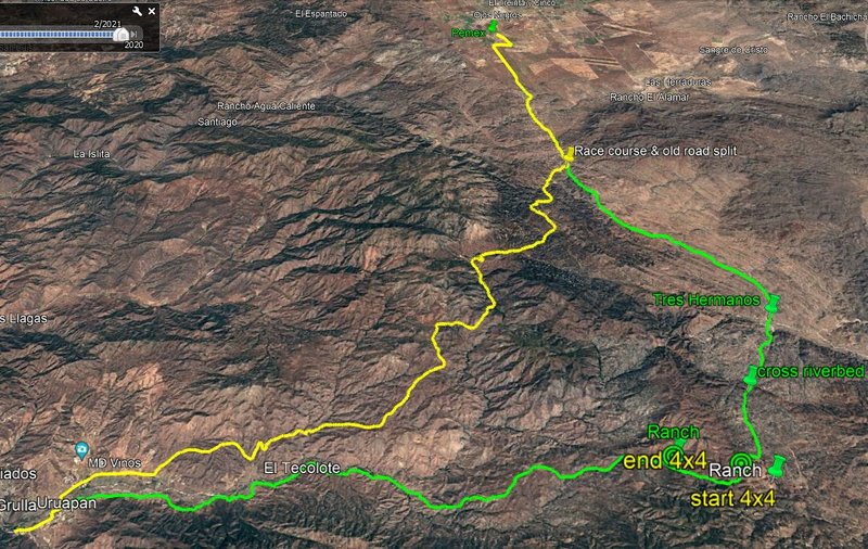
South from Ojos Negros, the yellow route shows the commonly used race course. The green (much older route) separates a little north of Tres Hermanos.
At the gate just outside the south end of Tres Hermanos is a sign to Uruapan - stay straight, the road left heads toward El Alamo.
We drove it (green route) 2 or 3 years ago and the portion where I've noted the start and end of a 4x4 section was badly torn up. There were no 4
wheel vehicle tracks. Deeply rutted and rocky. No locked gates at that time.
edited to add: where I show 4x4 I should have said both vehicles used low range with lockers for that section - I seem to recall it was about one mile
in distance, first part up, second part downhill.
I do have a kml or gpx file if this is the route you are interested in.

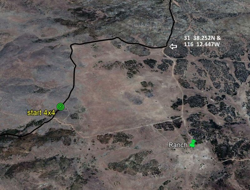
A few miles beyond (southbound) from Tres Hermanos there is a ranch on what appears to be the main road. We encountered a sign to not go through the
ranch, so we bypassed it on an alternate, but, travelled road. The GPS coordinates at the intersection is shown on the map below.

John M
[Edited on 1-15-2022 by John M]
[Edited on 1-15-2022 by John M]
ehall - 1-15-2022 at 06:34 AM
The green route has a gate. Go to the ranch and pay 5 bucks per bike and they will let you thru.
gate
John M - 1-15-2022 at 08:07 AM
Thanks for jogging my memory ehall - now I seem to recall that that is the reason we detoured around the ranch. The way we went, I believe, is
actually a well-defined route that follows a fence line, I would think that it's an alternate simply to avoid dealing with the ranch.
John M
David K - 1-15-2022 at 09:10 AM
What would be of interest along this road that makes it desirable for Nomad explorers? Or, is is simply a way to get from Point A to Point B without
using pavement or going through Ensenada? I know SCORE often goes through here for races.
Any old mines or hot springs?
bajaric - 1-15-2022 at 10:40 AM
Lots of mining history there.
In the 1880's the route from the north was the trail from Real del Castillo to the El Alamo mining district. It passed by Rancho Santa Clara, and
thus the early name for the district was the Santa Clara mines. This was the route to El Alamo from the border at Tia Juana, via a steep grade up to
Real del Castillo east of modern day La Cetto winery in the Guadalupe Valley.
Miners who went to El Alamo from Ensenada used the trail from Urapan. Both routes were abandoned by around 1900 when a better road east from Ensenada
was built up to Ojos Negros and on to El Alamo that followed the approximate route of Hwy 3.
100X - 1-15-2022 at 10:49 AM
"What would be of interest along this road that makes it desirable for Nomad explorers?"
Sometimes it is just the trail itself that is the draw!
Why?
John M - 1-15-2022 at 03:24 PM
Fact of the matter is that many years ago - late 70s - when we ran the SCORE checkpoint at Tres Hermanos on several occasions, we had taken this route
either before or after the race. So a few years ago when TW & I were planning a trip we thought this would be a good idea. Well heck, we had taken
the Compadre Trail south from Tecate, got gas in Ojos, and off to an adventure we hadn't done in a really long time.
The race course has more recently taken what is showing as the yellow route I think - correct me if I'm wrong.
Anyway it was a fun drive and just like 100x said - the trail itself was the impetus.
John
David K - 1-15-2022 at 03:33 PM
Super!!!

Tres Hermanos trail
ztrab - 1-15-2022 at 05:06 PM
Sent you an email John, thank you. Were on 500cc dirt bikes and the attraction is dirt vs asphalt. This route lets me get to the Pacific and run the
beaches for a bit, something a lot of my riders love to do - it's an On Any Sunday thing 
Tres Hermanos trail
ztrab - 3-2-2022 at 10:30 AM
rode the trail last week; yep the gate at the rancho was locked and the rancher waived us to come around the fence. $ 5 bucks a head and we were back
on the road. Lots of local only traffic signs, which got very amusing as the road deteriorated as we climbed over the hills toward the summit and the
now abandoned ranch with he blue ford pick up parked with flats. Last time I was through in 2017 or 2019, the ranch house was occupied; there were no
locked gates. Still 5 bucks is a cheap price to pay for a great short cut to Uruapan. Love that the road was rutted and gnarly enough in a few spots
to discourage a lot of traffic. Did encounter about a dozen riders going east a few miles west of the now unoccupied rancho.
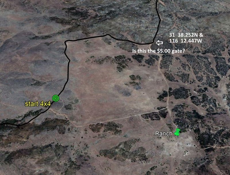
$5.00 gate?
John M - 3-2-2022 at 02:13 PM
Is this the $5.00 gate? I do not know why the image is so small but I'm writing about the gate in the upper right hand corner of the image.

Did you ride toward the ranch house or the trail to avoid it? When we got to that point I do not recall a fence or gate blocking the bypass. But, as I
get older I do tend to forget.
John M
[Edited on 3-2-2022 by John M]
David K - 3-2-2022 at 04:10 PM
You must have selected or were accidentally on a smaller size when you uploaded it... Check your upload size selection

The file size was small, so no need to use Postimages to share... I just downloaded your original image and posted it using Nomad attachment.
[Edited on 3-2-2022 by David K]
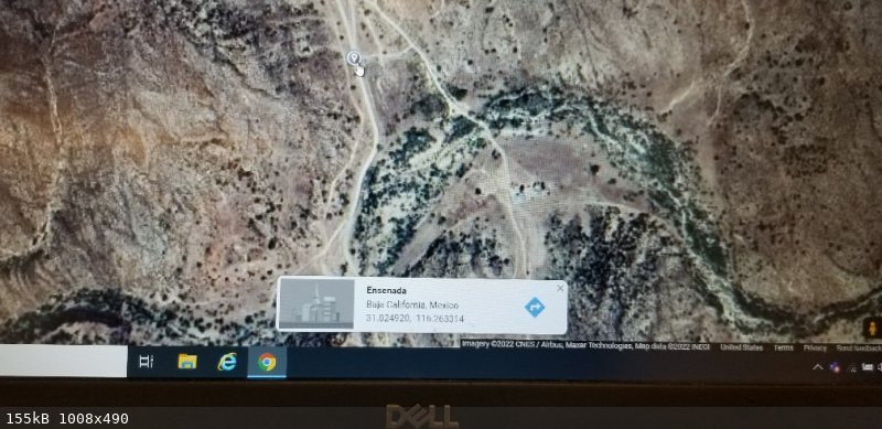
ehall - 3-2-2022 at 04:18 PM
Right hete

ztrab - 3-5-2022 at 03:33 PM
It's Rancho El Mezcal in Ehall's pic. that you divert through and pay. The locked gate is here: N31 49.490 W116 15.799 (Garmin format)


