BajaNomad

Bahia Las Animas

Mulege Canuck - 2-18-2022 at 07:09 PM

I have wanted to go to Las Animas for long time. I met two friends in BOLA and we left early the next day. It is 40 km of washboard to get to the turn off to Las Animas. It was a 20 km/hr slog with a full sized truck camper.

A89ADEAC-3657-48B4-90B4-9195904EFB8F.jpeg - 75kB
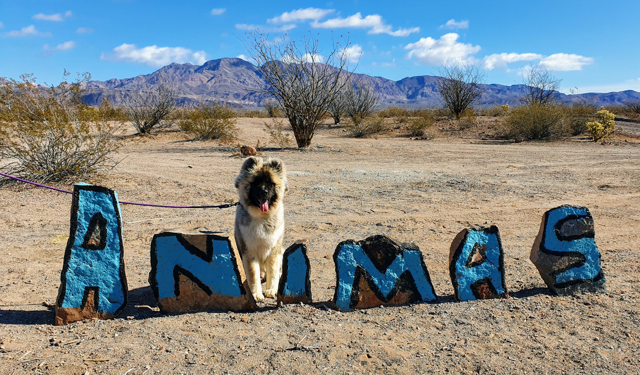
The sign at the main road.

Once off the Baja 1000 route, the road was great. However the Mesquite had over grown the road significantly and I had to use my electric pole saw to cut our way in. It took 4 .5 hrs! I should have probably brushed out the last 2 km a bit more but we were sick of it so we got some Baja pinstripes. It took us 1.5 hrs on the way out.


41A84C03-7D9C-4EAA-8A4B-AEC562CAAED2.jpeg - 117kB
My buddy with my dog, Brian. We hiked a nice hill with a great view of the Estero.


Once we setup camp we were greeted by Miguel with a basket of free firewood. Nice guy. He lives there in an old Airstream. His buddy Horacio, came over the next day with Las Animas t- shirts to sell. We bought a few.

Animas is a spectacular spot. The only downside was the reefs have been gill-netted daily and there was nothing to catch. It took us 4 hours just to get two Trigger fish.

After talking with Miguel, he said the fishing in May is great when the Rooster Fish and Yellow Tail come into the bay to feed on schools of Mullet. We were told the road is usually graded 3 to 4 months after the Baja 1000.

I probably won’t go back given the poor fishing and snorkeling, but it would be worth the effort to bring a full sized truck camper in there in May. Enjoy the brushed out road.

advrider - 2-18-2022 at 09:07 PM

Nice, on the list to visit. Would love to see some more pictures. Thanks for the report.

JZ - 2-18-2022 at 09:13 PM

Very cool. Nice photos. How was the temperature?

Appreciate you widening the trail a bit.


AKgringo - 2-18-2022 at 09:26 PM

I drove in there in the late afternoon a little over a year ago. It was just my dog and I, and we did not set up a camp.

I don't know if I wound up near a coyote den, or if they were just curious, but a couple of them seemed to shadow us as we pulled in, and again the next morning when we were pulling out.

We had no problems with them, they were not aggressive, but they weren't shy either!

Mulege Canuck - 2-19-2022 at 06:30 AM

Quote: Originally posted by AKgringo  
I drove in there in the late afternoon a little over a year ago. It was just my dog and I, and we did not set up a camp.

I don't know if I wound up near a coyote den, or if they were just curious, but a couple of them seemed to shadow us as we pulled in, and again the next morning when we were pulling out.

We had no problems with them, they were not aggressive, but they weren't shy either!


My Shepard was working overtime around the campfire. Lots of coyotes.

Mulege Canuck - 2-19-2022 at 06:38 AM

Quote: Originally posted by advrider  
Nice, on the list to visit. Would love to see some more pictures. Thanks for the report.


C85240EE-50B4-4664-B99E-99684267DD7F.jpeg - 67kB
View of the small islands in the bay.

766769D2-1C7A-4431-AC8C-B2104960F172.jpeg - 67kB
Large clam bed in the Estero.


B9D5B8C6-AB70-466A-9F00-68072971A1F3.jpeg - 55kB
The Estero at low tide. Lots of small fish in there but no Corvina unfortunately.

High tide was late at night when we were there. Would be nice kayaking if you get the tides to work for you.

Santiago - 2-19-2022 at 07:50 AM

Was the fish camp empty except for the two you mentioned? I would go there many times by boat and fish Barnabe and the south wall of the bay in the early 2000s. Each year the fishing became worse and worse.

There always seemed to be a dozen or so folks in the fish camp and the fish trucks from Ensenada would come each week. That must be all over now, why do the work of stringing gill nets if nothing will get in them?

Skipjack Joe - 2-19-2022 at 08:03 AM

Low tide

24799443_1770754296299832_5398855772316695986_o.jpg - 78kB

Mulege Canuck - 2-19-2022 at 08:19 AM

Quote: Originally posted by Santiago  
Was the fish camp empty except for the two you mentioned? I would go there many times by boat and fish Barnabe and the south wall of the bay in the early 2000s. Each year the fishing became worse and worse.

There always seemed to be a dozen or so folks in the fish camp and the fish trucks from Ensenada would come each week. That must be all over now, why do the work of stringing gill nets if nothing will get in them?


Pangas come every day from BOLA, then return at night. Miguel and Horacio work for them.

mtgoat666 - 2-19-2022 at 08:27 AM

Is La Unica property still around? (Former Fermin smith property). I recall someone bought the eco-camp, never heard of it since….

And is there still a yurt camp at las animas? Is it in business?

Mulege Canuck - 2-19-2022 at 08:32 AM

Quote: Originally posted by mtgoat666  
Is La Unica property still around? (Former Fermin smith property). I recall someone bought the eco-camp, never heard of it since….

And is there still a yurt camp at las animas? Is it in business?


That bay is north of where we were. Not sure if the yurt camp is still there.

AKgringo - 2-19-2022 at 08:49 AM

On my last trip in there just before Thanksgiving 2020, I only encountered one person. He was a fisherman left to gaurd some equipment stored there.

I poked around a bit on the roads (trails) heading around the north bay, but did not do a very thorough exploration. I did not stumble upon a yurt camp, but could easily have missed it.

There had been a recent rain event that settled the dirt, and there only appeared to be one set of tracks, other than mine going in, and out.

I also got a few pinstripes on my Isuzu Trooper, so I can imagine what it was like for a truck/camper. I don't have any old adventures to compare the road conditions to, but it appears to have changed due to storms a couple of times.

David K - 2-19-2022 at 09:17 AM

The fish camp was deserted in Jan. 2017. A lone gringo was camping near by, next to the lagoon/ estero. I drove past the mangroves and camped on the north-facing beach, opposite the island. The road was bumpy but the shrubs hadn't yet grown into it.
Photos at Las Animas in 2017: https://vivabaja.com/p117-page3/

I had driven in before, but not camped there in 2004 and 2009 (lost mission search).

The place was were Marv Sherrill and his Dana Point High marine biology class had annual field trips. Marv was the creator of the Baja Calendar in the early 2000s to raise funds so all his students could attend the one-week camping trip.


Marv and his calendar in 2003.


4x4abc - 2-19-2022 at 10:29 AM

standing right between the Indian graves
there are more on the hill below

indian graves.jpeg - 117kB

thebajarunner - 2-19-2022 at 10:39 AM

What a change...
No one there???

Couple years ago we drove in, yeah pinstripes, but not bad
There were several rather permanent looking campers there and they were a grim looking bunch

(Faint strains of a banjo playing the theme from "Deliverance"???)

We decided that camping at La Gringa was a much safer bet.

Mulege Canuck - 2-19-2022 at 12:36 PM

Quote: Originally posted by 4x4abc  
standing right between the Indian graves
there are more on the hill below


Your sure they are native graves? What is your source that you read to confirm that Harold?

I thought it was a cairn. But hey what do I know.

Thanks

Ron

David K - 2-19-2022 at 01:20 PM

Eric Ritter (archeologist) has researched the graves and interesting sites at Las Animas (but not the mission-era walls in question). See his published paper on Las Animas.

Mulege Canuck - 2-19-2022 at 03:03 PM

Thanks David

David K - 2-19-2022 at 03:39 PM

I can't find a specific paper for his work on Las Animas, but here is an overview of this busy man's efforts:

http://www.pcas.org/documents/534Ritter.pdf

https://www.academia.edu/35558571/Eric_Ritters_Role_in_the_D...

4x4abc - 2-19-2022 at 04:48 PM

Quote: Originally posted by Mulege Canuck  
Quote: Originally posted by 4x4abc  
standing right between the Indian graves
there are more on the hill below


Your sure they are native graves? What is your source that you read to confirm that Harold?

I thought it was a cairn. But hey what do I know.

Thanks

Ron


I am not a pro. I have no credentials.

But I have been to several historic burial sites in Baja - and the look and "feel" of the mountain top at Animas is identical to those other sites. It seems to me that Indians used to favor hilltop sites.
Interesting connection to our current past - many Baja cemeteries are on hilltops.

Screen Shot 2022-02-19 at 4.46.58 PM copy.jpg - 215kB

pjpvi - 2-20-2022 at 12:12 PM

Some friends and I visited Las Animas last October for the first time. We camped past the airstream a ways and closer to a couple houses up on the hill. One seemed occupied and the other looked like it was stalled out construction project. We were sad to see the trash at the old fish camp on the point. What a mess, but seems typical throughout Baja of abandoned fish camps in my experience.

The mangroves were cool. Next time I'd like to paddle board around them but we only stayed the one night this time.

There was a great looking camp spot just as we entered Las Animas area but was occupied on the way in. Will try to get it sometime in the future. Looked like some good hammock trees!

Some pics and drone footage of Las Animas starting at 6:50 in the the video I made of this trip.


PXL_20211028_163850086.jpg - 300kB PXL_20211028_152242960.jpg - 266kB PXL_20211028_151718874.jpg - 262kB PXL_20211028_135852583.jpg - 268kB

David K - 2-20-2022 at 05:07 PM

Very enjoyable... So you liked the Concepción Peninsula, a lot?
In 2016, We missed getting into Las Pintadas canyon and went up Tres Marias, instead... seeing water in these desert hills is neat!

JZ - 2-20-2022 at 06:09 PM

Another great way to experience it is by boat. You can pay a panga to take you there. It's a little less than 20 miles. Even faster than driving a truck to it.

We visited in Dec 2019. There were several ppl camping there. The trail was wide enough for my 3/4 ton, unless I'm mis-remembering.


[Edited on 2-21-2022 by JZ]

pjpvi - 2-21-2022 at 09:20 AM

Quote: Originally posted by David K  
Very enjoyable... So you liked the Concepción Peninsula, a lot?
In 2016, We missed getting into Las Pintadas canyon and went up Tres Marias, instead... seeing water in these desert hills is neat!


It was the first time I explored it at all and yes, I liked it. Had the little mechanical issue that caused us to pause and get repaired in Mulegé, but then got back to it. I'd like to spend a bit more time out there one of these trips exploring more.

David K - 2-21-2022 at 09:28 AM

Quote: Originally posted by pjpvi  
Quote: Originally posted by David K  
Very enjoyable... So you liked the Concepción Peninsula, a lot?
In 2016, We missed getting into Las Pintadas canyon and went up Tres Marias, instead... seeing water in these desert hills is neat!


It was the first time I explored it at all and yes, I liked it. Had the little mechanical issue that caused us to pause and get repaired in Mulegé, but then got back to it. I'd like to spend a bit more time out there one of these trips exploring more.


Did you see the Gavilan manganese mine of WWII, over on the east side of the point? I wanted to, but we couldn't get close to the point in 2016 following a hurricane! I think we were 8 miles from the north beach when the road was washed out from floods. Before that point, the brush sure scratched up my truck!

Nomad 'geoffff' went there in his 4WD van in 2019 but rode his bike over to the mine from the beach camp. https://octopup.org/baja2019

pjpvi - 2-21-2022 at 06:31 PM

Quote: Originally posted by David K  
Quote: Originally posted by pjpvi  
Quote: Originally posted by David K  
Very enjoyable... So you liked the Concepción Peninsula, a lot?
In 2016, We missed getting into Las Pintadas canyon and went up Tres Marias, instead... seeing water in these desert hills is neat!


It was the first time I explored it at all and yes, I liked it. Had the little mechanical issue that caused us to pause and get repaired in Mulegé, but then got back to it. I'd like to spend a bit more time out there one of these trips exploring more.


Did you see the Gavilan manganese mine of WWII, over on the east side of the point? I wanted to, but we couldn't get close to the point in 2016 following a hurricane! I think we were 8 miles from the north beach when the road was washed out from floods. Before that point, the brush sure scratched up my truck!

Nomad 'geoffff' went there in his 4WD van in 2019 but rode his bike over to the mine from the beach camp. https://octopup.org/baja2019


Nope. We turned back at 26.775323 -111.818054 as the trail had gotten extremely narrow with brush and it was unbearable driving through it. I'm fine with pin striping and the van finish is nothing to really protect, but the noise was more than we could bear. Looking at GE once we got back had we gone just a little bit further it opened back up again. Maybe next time.

4x4abc - 2-21-2022 at 06:42 PM

Gavilan has some cool grave sites

DosMars - 3-17-2022 at 01:55 PM

Quote: Originally posted by pjpvi  


There was a great looking camp spot just as we entered Las Animas area but was occupied on the way in. Will try to get it sometime in the future. Looked like some good hammock trees!


Can't find pics at the moment but I can confirm, those are some great hammock trees! Nice and shady...
The big tree there is really cool. I can't remember what kind it is but it drips brine from its leaves.


AKgringo - 3-17-2022 at 03:05 PM

I don't know the genus and species of those trees, but I have heard them referred to as "salt pines".

Skipjack Joe - 3-17-2022 at 04:28 PM

Quote: Originally posted by DosMars  
Quote: Originally posted by pjpvi  


There was a great looking camp spot just as we entered Las Animas area but was occupied on the way in. Will try to get it sometime in the future. Looked like some good hammock trees!


Can't find pics at the moment but I can confirm, those are some great hammock trees! Nice and shady...
The big tree there is really cool. I can't remember what kind it is but it drips brine from its leaves.


The vultures love those trees. You can get real close to them in the mornings when they're warming up with wings wide apart.


IMG_1297b.jpg - 151kB

[Edited on 3-17-2022 by Skipjack Joe]

4x4abc - 3-17-2022 at 04:51 PM

the trees are Casuarinas, native to Australia and east Africa
almost a sure sign that the Jesuits visited the area
they grow fast, accept salty water and provide good wind shelter

sad part is that the increased number of tourists is fatal to those trees
tourists need firewood
some of those magnificent trees have been reduced to stumps

cut tree copy.jpg - 179kB

4x4abc - 3-17-2022 at 04:54 PM

the ones still standing all have limbs missing

cut Casuarina 800.jpg - 194kB

AKgringo - 3-17-2022 at 05:25 PM

Harald, everything about that cut off limb in the bottom photo looks like it was dead for a good period of time before it was removed.

mtgoat666 - 3-17-2022 at 07:03 PM

Quote: Originally posted by 4x4abc  
the trees are Casuarinas, native to Australia and east Africa
almost a sure sign that the Jesuits visited the area
they grow fast, accept salty water and provide good wind shelter

sad part is that the increased number of tourists is fatal to those trees
tourists need firewood
some of those magnificent trees have been reduced to stumps


You pics only show trunk clearly, hard to discern leaves or seed pods,… but trunk sure looks like tamarisk (tamarix, or salt cedar). If tamarisk, it’s An invasive species, best people eradicate it, feel free to burn or poison it whenever you find it!

[Edited on 3-18-2022 by mtgoat666]

David K - 3-17-2022 at 07:08 PM

Quote: Originally posted by AKgringo  
I don't know the genus and species of those trees, but I have heard them referred to as "salt pines".

Perhaps the Salt Cedar, or Tamarisk, such as those grown at Nuevo Mazatlan and other Campos near San Felipe and gulf coast sites?

Note, there are many varieties of Tamarisk. These are not the kind that spread out and have caused havock in waterways.

AKgringo - 3-17-2022 at 07:21 PM

Salt Cedar makes more sense than what I posted. That is probably what I was told they were. :no:

mtgoat666 - 3-17-2022 at 07:35 PM

Quote: Originally posted by David K  

Note, there are many varieties of Tamarisk. These are not the kind that spread out and have caused havock in waterways.


There is no such thing as a good tamarisk in western North America. It’s all bad.

Skipjack Joe - 3-17-2022 at 08:35 PM

Quote: Originally posted by mtgoat666  
Quote: Originally posted by 4x4abc  
the trees are Casuarinas, native to Australia and east Africa
almost a sure sign that the Jesuits visited the area
they grow fast, accept salty water and provide good wind shelter

sad part is that the increased number of tourists is fatal to those trees
tourists need firewood
some of those magnificent trees have been reduced to stumps


You pics only show trunk clearly, hard to discern leaves or seed pods,… but trunk sure looks like tamarisk (tamarix, or salt cedar). If tamarisk, it’s An invasive species, best people eradicate it, feel free to burn or poison it whenever you find it!

[Edited on 3-18-2022 by mtgoat666]


Pretty sure Harrald is right. This is not a tamarisk.

Don Pisto - 3-17-2022 at 10:11 PM

and then the stream oaks!
https://www.bbc.com/future/article/20220222-the-mystery-of-m...