BajaNomad

Driving from El Cardonal to Bahia de los Muertos

Doug Landolfi - 7-4-2022 at 09:53 AM

Has anyone made the drive north from the El Cardonal area staying as close to the coast as possible - a "road" on some maps labeled "Los Barriles - Santa Teresa"?

AKgringo - 7-4-2022 at 10:26 AM

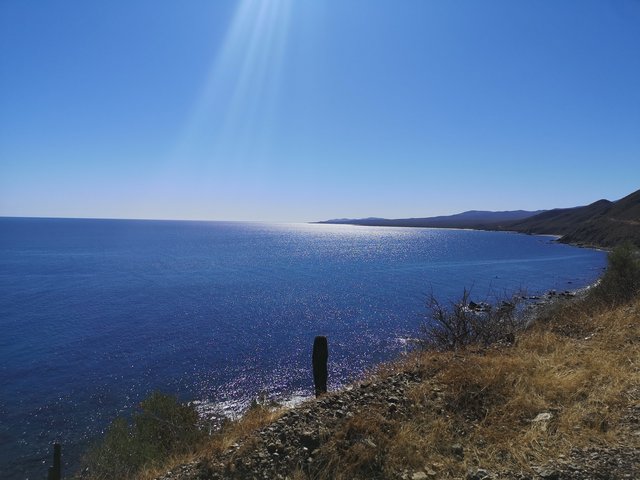
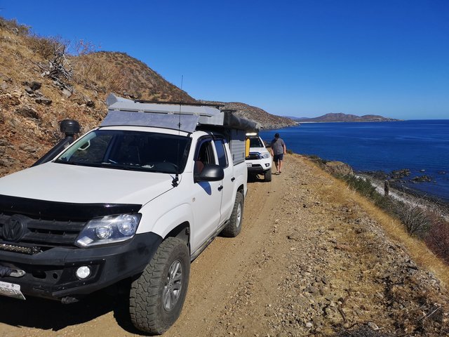
That is one of my favorite drives in Baja Sur. It can be challenging after any storm system, and grading seems to be random if at all, but there are some incredible views along that route.

Four-wheel drive is best, but an experienced driver in a 2wd with good clearance should be fine.

Doug Landolfi - 7-4-2022 at 10:36 AM

Thank you AKgringo!

I have camped at Punta Arena, and have fished in Bahia de los Muertos. From a panga in the bay, I have wondered about the
few residences (?) one can see from the water, along that shore line - and wondered "how the heck do you get there?!?"

Have you found any beaches at which to camp along that stretch of coastline?

AKgringo - 7-4-2022 at 10:51 AM

I have camped on the beaches north of El Cardonal, but once you start climbing away from the flat stretch of road, there are only a few possible trails down to tide line.

The only traffic I passed on that road two years ago were some SXS UTVs, but I know that ranchers use the road. I saw a few places that might be good campsites crossing over the pass, but have not used one of them yet.

[Edited on 7-4-2022 by AKgringo]

AKgringo - 7-4-2022 at 10:55 AM

I should add that for quite a bit of that route, you are literally on the side of a cliff! :wow:

willardguy - 7-4-2022 at 12:09 PM

in the late 80's I did it in a rented Tsuru......we made but I wouldn't recommend it, pretty much crushed the bottom of that nissan:(

Doug Landolfi - 7-4-2022 at 12:46 PM

Thank you both. Man, that coastline along Bahia de los Muertos - if accessible - would be heaven on earth. To have a camper on a beach, and a boat to access the bay, would be perfecto!

pacificobob - 7-4-2022 at 12:58 PM

I've made the drive a number of times over the years. Some trips were do-able with 2 wheel drive...other times challenging on a dirt bike. Like many baja roads, ones local knowledge is only useful for the period since the last big rain.

AKgringo - 7-4-2022 at 01:07 PM

The road leaves the coast probably five miles or more before it would reach Los Muertos. I don't know if there is a trail that continues to head that way, but the route I followed crosses over a summit and intersects the main road a few miles east of Los Planes.

[Edited on 7-4-2022 by AKgringo]

Doug Landolfi - 7-4-2022 at 01:30 PM

Yup - I see on a map exactly what you are describing. The "road" turns from north to west, and heads towards 286.

I have in my head that I am going to buy a boat in La Paz during my next trip, and spend some time exploring that coast from the water. Find places to land a dinghy, and do some hiking from the shoreline.

KRB - 7-4-2022 at 02:59 PM

Last time I drove it about a year and a half ago I was in a UTV and came across a couple is a full size 2 wheel drive pickup headed to La Paz. Google maps had told them this was the best route for Los Barriles to La Paz. Thank you Google

This road makes the old rood from Los Barriles to Cardonal look like the interstate

elgatoloco - 7-4-2022 at 04:06 PM

In 1999 we took the road north in a F-350 4WD Crew Cab Long Bed. We had been camping for a couple of weeks all along the east cape on different beaches and ended up at El Cardonal. Instead of going south I thought we should check out the road north. The road was very narrow in spots and at times the wife was looking straight down into the sea. More the once she told me to move left when there was no room to do that and a few times I pulled me side mirror in. We stopped periodically to get out and marvel at the views. I have some photos looking down at big schools of large fish in the very clear waters. At one point we saw humpbacks offshore breaching and slapping fins on the water. It was a bit of pucker factor ride not knowing what was ahead but I recall thinking if a another vehicle is heading south it will be smaller and have to back up. Their were places to turn around or pass in the areas where the road went down into arroyos. The last arroyo heading away from the sea and toward the asphalt had a very short stretch of big boulders that required some rock crawling and the thought of having to maybe turn around. We made it thru with no damage to the undercarriage which was good because it was a borrowed rig.

It was one of the coolest roads we have taken and I have always wanted to do it again and take the time to explore some of the beaches but maybe in something a little smaller.

advrider - 7-4-2022 at 04:42 PM

Where is David with a map when you need one? Headed to my latest Baja Atlas now.

David K - 7-4-2022 at 04:56 PM

Quote: Originally posted by advrider  
Where is David with a map when you need one? Headed to my latest Baja Atlas now.


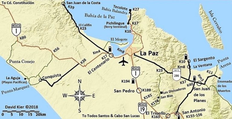
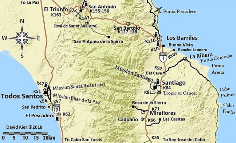
My Maps:


We drove it in 2012 with BajaTripper in his 4Runner on Day 6 of the trip, photos on the second page: https://vivabaja.com/p712/

We stayed close to the coast via Punta Pescadero and did not take the paved road that goes into the hills.

The only rough part was leaving the coast and crossing the ridge to meet the paved road between Los Planes and Ensenada de los Muertos.

AKgringo - 7-4-2022 at 04:56 PM

For what it is worth, the road that runs between hwy 286 and hwy 1 at San Antonio is a good, paved road. It would make a nice loop route if your plan is not to continue on northward.

[Edited on 7-5-2022 by AKgringo]

AKgringo - 7-4-2022 at 05:05 PM

Thanks for the maps David! Talking about possible loop routes, the dirt road that runs between 286 and 1 (west of the paved road) is a well graded dirt road that I found very enjoyable.

David K - 7-4-2022 at 10:11 PM

Quote: Originally posted by AKgringo  
Thanks for the maps David! Talking about possible loop routes, the dirt road that runs between 286 and 1 (west of the paved road) is a well graded dirt road that I found very enjoyable.


I did not drive it, no... but it is on the map as it is well-signed. Did you visit the church in San Blas? The trail up to the La Paz mission visita of Angel de la Guarda goes up from there. Photos of it from Jack Swords in his section on VivaBaja.com

bajafreaks - 7-5-2022 at 06:02 AM

Quote: Originally posted by AKgringo  
I have camped on the beaches north of El Cardonal, but once you start climbing away from the flat stretch of road, there are only a few possible trails down to tide line.

The only traffic I passed on that road two years ago were some SXS UTVs, but I know that ranchers use the road. I saw a few places that might be good campsites crossing over the pass, but have not used one of them yet.

[Edited on 7-4-2022 by AKgringo]


This is exactly right, did the drive in May this year. 4 people in a 4 seat SXS I didn't see any access to the beach once we started climbing out of El cardonal a lot of great views but not down at beach level all cliff side. The road is really rocky best with 4x4.

4x4abc - 7-5-2022 at 06:54 AM

Quote: Originally posted by bajafreaks  


This is exactly right, did the drive in May this year. 4 people in a 4 seat SXS I didn't see any access to the beach once we started climbing out of El cardonal a lot of great views but not down at beach level all cliff side. The road is really rocky best with 4x4.


one beach access about midway
23.926066°, -109.836383°
good camping - beach is super rocky

another beach access north from there is blocked off as private property

Marty Mateo - 7-5-2022 at 10:05 AM


Great coast road all the way from Los Barriles. The only potentially rough area is where the road leaves the coast and heads towards Los Planes. Drove the road down through El Triunfo to Los Barriles on Saturday, very lush and green till just south of San Bartolo, always enjoy that drive through the mountains. A few arroyo areas north of El Cardinal that should make beach access possible for camping.

mtgoat666 - 7-5-2022 at 10:19 AM

Quote: Originally posted by 4x4abc  
Quote: Originally posted by bajafreaks  


This is exactly right, did the drive in May this year. 4 people in a 4 seat SXS I didn't see any access to the beach once we started climbing out of El cardonal a lot of great views but not down at beach level all cliff side. The road is really rocky best with 4x4.


one beach access about midway
23.926066°, -109.836383°
good camping - beach is super rocky

another beach access north from there is blocked off as private property


there are quite a few other beaches accessible there. you just have to hike/scramble....
sometimes ya gotta get out of the car and use your feet!

AKgringo - 7-5-2022 at 11:41 AM

Quote: Originally posted by 4x4abc  


one beach access about midway
23.926066°, -109.836383°
good camping - beach is super rocky

another beach access north from there is blocked off as private property


Harald, I zoomed in on that co-ordinate using ariel view. I had no problem accessing the beach in my Isuzu Trooper in Nov 2020. The red roofed building looked like it was abandoned more than a couple of years ago.

I was going to camp there, but I was headed south and knew that my dog would be much happier on the beaches further down the road. Running and digging are two of her favorite things, right behind sniffing around everywhere!

4x4abc - 7-5-2022 at 12:01 PM

Quote: Originally posted by Marty Mateo  

Great coast road all the way from Los Barriles. The only potentially rough area is where the road leaves the coast and heads towards Los Planes. Drove the road down through El Triunfo to Los Barriles on Saturday, very lush and green till just south of San Bartolo, always enjoy that drive through the mountains. A few arroyo areas north of El Cardinal that should make beach access possible for camping.


none of my maps know El Cardinal

David K - 7-5-2022 at 12:08 PM

Quote: Originally posted by 4x4abc  
Quote: Originally posted by Marty Mateo  

Great coast road all the way from Los Barriles. The only potentially rough area is where the road leaves the coast and heads towards Los Planes. Drove the road down through El Triunfo to Los Barriles on Saturday, very lush and green till just south of San Bartolo, always enjoy that drive through the mountains. A few arroyo areas north of El Cardinal that should make beach access possible for camping.


none of my maps know El Cardinal


Why the correct spelling of place names in Baja is important...
It is the small town where the paved and dirt roads meet, north of Los Barriles... My maps just missed including it, north of Punta Pescadero, on the coast.

Marty Mateo - 7-5-2022 at 12:16 PM

Quote: Originally posted by 4x4abc  
Quote: Originally posted by Marty Mateo  

Great coast road all the way from Los Barriles. The only potentially rough area is where the road leaves the coast and heads towards Los Planes. Drove the road down through El Triunfo to Los Barriles on Saturday, very lush and green till just south of San Bartolo, always enjoy that drive through the mountains. A few arroyo areas north of El Cardinal that should make beach access possible for camping.


none of my maps know El Cardinal

👍 thanks for pointing out the miss spelling

gnukid - 7-5-2022 at 08:14 PM

I live at both ends of the road on either side. Here is some info that is helpful without ruining the adventure, since there is so much to see, and many beach accesses and beach fishing spots.

As you are coming over the hill from La Paz, there is the dirt turn off to San Blas sort of around the peak. San Blas is a church and there are many ranchos, some of which sell plants, chachkas or treats. The road is generally excellent for a dirt road. Or you can take it on the return.

You can incorporate El Triunfo and San Bartolo into your trip at some point both are excellent towns but sometimes everything is closed.

At the entrance to La Ventana is a tow truck "Grua" service with large trucks, a short way off the 286 toward La Ventana is a tire shop. This is the major tow service if you need a tow back to La Paz due to catastrophic failure. Ask here or ask around for the number.

As you enter Los Planes there is a Chevron gas station which is the only option in the region, its short on liters, but gas is good.

There is one reliable mechanic shop, its white and called Pinos, they can fix a flat or valve, or do most service, friends have had motors rebuilt there but they need to go get parts so anything big is a multi day project. They are generally responsive to emergency issues on the spot.

I don't know of a good grocery store in Los Planes, but there are many small stores and fruit stands. If you continue past "La Curva" entrance to Boca del Alamo and instead continue to Agua Amrga, there are two good stores, one on the road called "Greens" with ice and drinks and meat and cheese, and beer and alcohol. Or inside the pueblo Agua Amarga is Luceros with staples.

Its close to continue toward Ensenada Muertos or to head toward "Turquesa" or Punta Arena. Turquesa has excellent quiet camping. Punta Arena is higher traffic. Muertos has access to Camp, sim and dive, and of course you can charter a fishing trip PM for contact. Restaurant 1535 is reliable.

Heading back to "La Curva" is the marked entrance to Boca Del Alamo up over the mountain dirt road there is usually no cars, except on the weekends there can be. The road going up is scary and has boulders going up but not impossible. There are spots with sharp boulders on steep sections that tear up tires, especially older or or street tires. Its only 15-20km to complete the pass as you arrive at Primeras Piedras, finally there is a run of 100 meters of very sharp rocks, but if you have 4x4 you can turn before to the beach and skip the rocks. There are three rustic cabanas there that are rentable with a solar light and simple cot and bathroom with some water. PM if you want to contact the person in charge who is family or ask at El Cangrejo store in Boca del Alamo.

The beach is a great place tp camp except for coyotes or foxes not sure which but there are many, snakes, cows, burros, goats, etc.

The large beach is created by a wide arroyo, see google maps, that cascade down from the highest mountain peak, and there can be a river in times of rain. In the mountains there are Yaqui cave paintings and you can get a guided hike if desired, ask at Crangrejo.

Its worth the short trip up the arroyo to the mountain range and explore a bit.

As you pass the arroyo the road rises and you enter the pueblo pf Boca del Alamo, at the second entrance is. store called el Cangrejo, where Regina sells fish, meat, cheese, veggies, eggs and drinks and you can ask there for anything you might want of you are camping, by request, or in relation to renting the rustic cabanas or guided hike, there is an emergency sat phone, and mechanic Remigio lives a few doors down for simple repairs.

You can camp right there in boca de Alamo on the protected beach walking distance to the stores or back on the long white sand beach or up the arroyo towards the mountain to get away from the wind.

In Cardonal there are two stores as you enter M.S. yellow and blue has beer, ice and drinks and across the street is a white and blue store that has fresh meats, like chicken, duck, turkey, goat, steak, bread and cheese and basics. There are a few taco stand restaurants in Cardonal.

As you hit the corner of the paved road that goes over the mountain, or continues straight to Punta Pescadero there is Restaurant Cielito Lindo which is excellent and reliable and has wifi and a pool. You can also rent rooms, they might be called Cabanas.

As you continue on the dirt road through Cardonal there are more beach access and protected spots for camping and diving, Sonadero is a nice little resort.

As you pass Punta Pescadero hotel you reach the beach proper and you can pull onto the beach and camp. With 4x4 you can pull down the way toward little protected spots. Punta Pescadero is excellent but more pricey.

Continue to Los Barriles, rinse, repeat.


mtgoat666 - 7-5-2022 at 08:36 PM

Quote: Originally posted by gnukid  
I live at both ends of the road on either side.


Quite an accomplishment.

gnukid - 7-5-2022 at 08:54 PM

FYI, today they were catching Dorado and Cabilla and Snapper. There are some Turtles arriving to lay nests and periodically there are Orca and Dolphins jumping.

Here's a shot of the creek running above the big arroyo above Boca del Alamo after rain.


DSC_4674.jpeg - 252kB

Boca del Alamo

IMG_1812.jpeg - 142kB

Vista a Muertos

IMG_1808.jpeg - 139kB

Turquesa


IMG_2636 (1).jpeg - 180kB

gnukid - 7-5-2022 at 08:57 PM

Quote: Originally posted by mtgoat666  
Quote: Originally posted by gnukid  
I live at both ends of the road on either side.


Quite an accomplishment.


It's all about tire pressure... until you fall off the cliff.

David K - 7-6-2022 at 08:45 AM

GREAT report gnukid !!!
Glad you also confirmed the San Blas road is still dirt.

The map from INEGI that Benchmark was using for the new Atlas showed it as a paved state highway! That was one of my edits, as I was pretty sure it was not paved... as I had seen it in 2017 on both ends. I figured Harald or another Nomad would have reported such a change.

4x4abc - 7-6-2022 at 09:32 AM

Quote: Originally posted by David K  
GREAT report gnukid !!!
Glad you also confirmed the San Blas road is still dirt.

The map from INEGI that Benchmark was using for the new Atlas showed it as a paved state highway! That was one of my edits, as I was pretty sure it was not paved... as I had seen it in 2017 on both ends. I figured Harald or another Nomad would have reported such a change.


I drove it a few days ago
steep climbs
radical turns
could not be paved the way it is

MEX1 to Los Divisaderos maybe
but there are no prep signs

AKgringo - 7-6-2022 at 09:43 AM

Harald, I am glad you agree that it is a good road. Flat, straight and paved is sooo boring!

4x4abc - 7-6-2022 at 09:52 AM

there is a second mining road crossing Sierra El Carrizalito
hiked it a while ago
cool old mining road
has been used by trucks some time ago
solid dozer work
not suitable for 4x4 any longer (washouts and rockslides)
perfect for mountain bike or dirt bike
no gates

dozens of mines and about 100 mining trails in the area


Screen Shot 2022-07-06 at 10.38.02 AM copy.jpg - 233kB

4x4abc - 7-6-2022 at 10:11 AM

my favorite is always the view of the shrine in the narrow arroyo part of the drive

capilla Guadalupe copy.jpg - 293kB

4x4abc - 7-6-2022 at 10:14 AM

the casita at the transition of rocky beach to sandy beach (Casa Chunique) is available on airbnb:
https://www.airbnb.com/rooms/3485966?adults=1&children=0...

gnukid - 7-6-2022 at 11:11 AM

Here is a hint... If you think this is inappropriate I'll delete. We've scheduled a Shaman to lead a psychedelic toad licking session for Goat here to reconnect and overcome inner anxiety, anger and reconnect the brain.


IMG_7312.jpeg - 280kB

[Edited on 7-6-2022 by gnukid]

Doug Landolfi - 7-10-2022 at 10:00 AM

This is a great + very informative thread. Thanks to everyone who contributed.

watizname - 7-11-2022 at 07:03 AM

Late 80's -early 90's on a trip south, spent a few days at Punta Arena camping and fishing near the lighthouse, and continued south on that road. Had a Chevy 4x4 with a cabover camper. Rough road but do-able. As I remember, there were a few spots with a pretty high pucker factor. Boy--- we had fun.

jbcoug - 7-11-2022 at 11:58 AM

I drove this a few years ago, north to south, in a 4x4 F150. A couple observations. The road was steep, very narrow, mostly softball sized rocks, and no where to turn around. Once committed, there was no turning back. There were a number of places where I was rubbing on the high side and part of a tire hanging over on the low side. Exciting times! Never saw another vehicle the entire route except a four wheeler a hundred feet down the bank jammed against a tree, looked like it had been there a couple years. Beautiful views at times but I pondered what a jam I would be in if I reached an impassable spot.

Sandlefoot - 7-11-2022 at 06:08 PM

Quote: Originally posted by 4x4abc  
Quote: Originally posted by Marty Mateo  

Great coast road all the way from Los Barriles. The only potentially rough area is where the road leaves the coast and heads towards Los Planes. Drove the road down through El Triunfo to Los Barriles on Saturday, very lush and green till just south of San Bartolo, always enjoy that drive through the mountains. A few arroyo areas north of El Cardinal that should make beach access possible for camping.


none of my maps know El Cardinal


23°50'47.07"N
109°45'3.02"W

4x4abc - 7-11-2022 at 06:22 PM

yup


Screen Shot 2022-07-11 at 7.21.18 PM copy.jpg - 122kB

David K - 7-12-2022 at 04:51 AM

See, I am not the only Nomad who is fussy about places being spelled correctly! LOL

alpha 1 - 7-12-2022 at 11:28 AM

a few years ago headed south


baja4.jpg - 194kB

[Edited on 7-12-2022 by alpha 1]

chippy - 7-12-2022 at 12:52 PM


Almost the same spot as alpha 1 in feb 2022.

David K - 7-12-2022 at 12:55 PM

Very cool!

chippy - 7-12-2022 at 12:55 PM

View north same day in feb.


chippy - 7-12-2022 at 01:20 PM


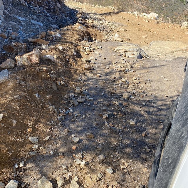
Going down the grade toward Los Planes.

AKgringo - 7-12-2022 at 01:45 PM

Five or six years ago, on the same stretch chippy just posted, the drive was complicated by two large boulders that fell on the road.

I was driving a Kia Sportage soft top (think of a Suzuki Samuri) so I was able to maneuver between them, but no full size rig would have a chance. The larger boulder was about ten feet in diameter!

KRB - 7-12-2022 at 02:30 PM

Last time I drove it about a year and a half ago I was in a UTV and came across a couple is a full size 2 wheel drive pickup headed to La Paz. Google maps had told them this was the best route for Los Barriles to La Paz. Thank you Google

This road makes the old rood from Los Barriles to Cardonal look like the interstate