BajaNomad

Hurricane Kay

 Pages:  1  

mtgoat666 - 9-4-2022 at 08:43 AM

Big storm shaping up:
https://www.nhc.noaa.gov/?epac

Impacting baja Sept 7 to 10

This one expected to travel far north, forecast to bring rain to entire peninsula and even San Diego…


[Edited on 9-5-2022 by mtgoat666]

surfhat - 9-4-2022 at 11:17 AM

What a glorious morning we had here in north San Diego coastal county. To wake up early with the smell of rain permeating the air was glorious.

After the last few days of sweltering in and over the 90 degree temps, this was a gift, for as long as it lasted. haha

Looks like more might be coming from that storm off of central Baja in the coming days.

There was lightning blowing up over the ocean in the wee dark hours before sunrise after the showers. A bit of far away thunder was also happening.

Ain't mother nature wonderful?


John Harper - 9-4-2022 at 12:03 PM

It was 84* at 6:30 in Carlsbad, 97* at noon! And, the humidity is way, way up. More like sister's place in St. Louis. No thanks.

John

mtgoat666 - 9-4-2022 at 12:12 PM

Horribly hot over night in San Diego. First time I can remember having AC on overnight. I wonder if the world is getting warmer ;)

Did the palm tree survive last weeks storm in BCS? Will it survive this weeks storm?

surfhat - 9-4-2022 at 12:13 PM

Tropical, here in the drought dry desert.

Humidity is good for us sometimes. Definitely sweats out the stuff we need to sweat out.

It could get old and why I never lived back east again after my college years in NC over the last fifty years. At least we don't have the mosquitoes and horseflies bugging us out here in the west.

Shade and a breeze gets me through every time.

Tropical Depression?

EdZeranski - 9-4-2022 at 01:34 PM

Quote: Originally posted by mtgoat666  
Big storm shaping up:
https://www.nhc.noaa.gov/?epac

Impacting baja Sept 7 to 10

Tropical Depression = ran out of rum ~8^0

mtgoat666 - 9-4-2022 at 01:46 PM

Now TS Kay, and soon to be hurricane.


Tropical Storm Kay Discussion Number 2
NWS National Hurricane Center Miami FL EP122022
400 PM CDT Sun Sep 04 2022

Satellite data indicate that the depression has strengthened into
Tropical Storm Kay. Although the convective pattern is still a bit
ragged, banding features have improved on the south side of the
cyclone. A pair of ASCAT passes from a few hours ago showed peak
winds around 35 kt to the northeast of the center. Based on that
data and the T2.5 Dvorak classification from TAFB, the initial
intensity is increased a little to 35 kt. Kay is a large storm with
its cloud field extending several hundred miles across, and some of
the outer bands are moving across the coast of southwestern Mexico.

The center is located a little to the north of the previous track,
and the estimated motion is now 290/11 kt. This general motion is
expected to continue for the next couple of days, keeping the core
of the system south of the coast of southwestern Mexico during that
time. Thereafter, the models all show a turn to the northwest and
then the north. Overall, there has been little change in the model
guidance this cycle and the solutions remain relatively tightly
clustered. Despite the tightly-clustered guidance, the GFS and
ECMWF ensemble spreads encompass as far east as the Gulf of
California and as far west as a few hundred miles west of the Baja
California peninsula. The NHC track forecast is a little to the
north of the previous one in the short term, due to the initial
position and motion, but ends up close to the previous track beyond
48 h.

Kay is likely to strengthen during the next few days while it
remains over warm water and embedded in a very moist environment.
Although the Rapid Intensification Indices in the SHIPS model are
relatively high, rapid intensification in the short term appears
unlikely given the broad structure of the cyclone and expected
moderate shear. The new NHC intensity forecast is largely
consistent with the previous one and shows steady strengthening
during the next 2 to 3 days. Beyond that time, weakening is
expected due to cooler SSTs. Regardless of the details, Kay is
expected to be a significant hurricane near Baja in a few days.

KEY MESSAGES:

1. Although Kay is expected to stay offshore, heavy rainfall could lead to localized flash flooding in portions of southwestern Mexico.

2. Interests in the Baja California peninsula should closely monitor Kay as tropical storm or hurricane watches could be required tonight or on Monday.

[Edited on 9-4-2022 by mtgoat666]

John Harper - 9-4-2022 at 01:52 PM

102* in Carlsbad at 1:45 PM. Not sure the humidity, but it's high. I wonder what the "heat index" is from that?


John


El Camote - 9-4-2022 at 02:05 PM

We're at 102 in Santa Barbara also. We have city ordinances against that kind of temperature. :fire:

AKgringo - 9-4-2022 at 02:16 PM

Coincidence...it hit 102 in Grass Valley for a while, and dryer than a popcorn fart! A fire started a couple of miles from me, but it got knocked down right away!

[Edited on 9-4-2022 by AKgringo]

Don Pisto - 9-4-2022 at 03:21 PM

close to a hundred on the beach in Puerto Nuevo area and humid....its nice to have some "weather" for a change:light:
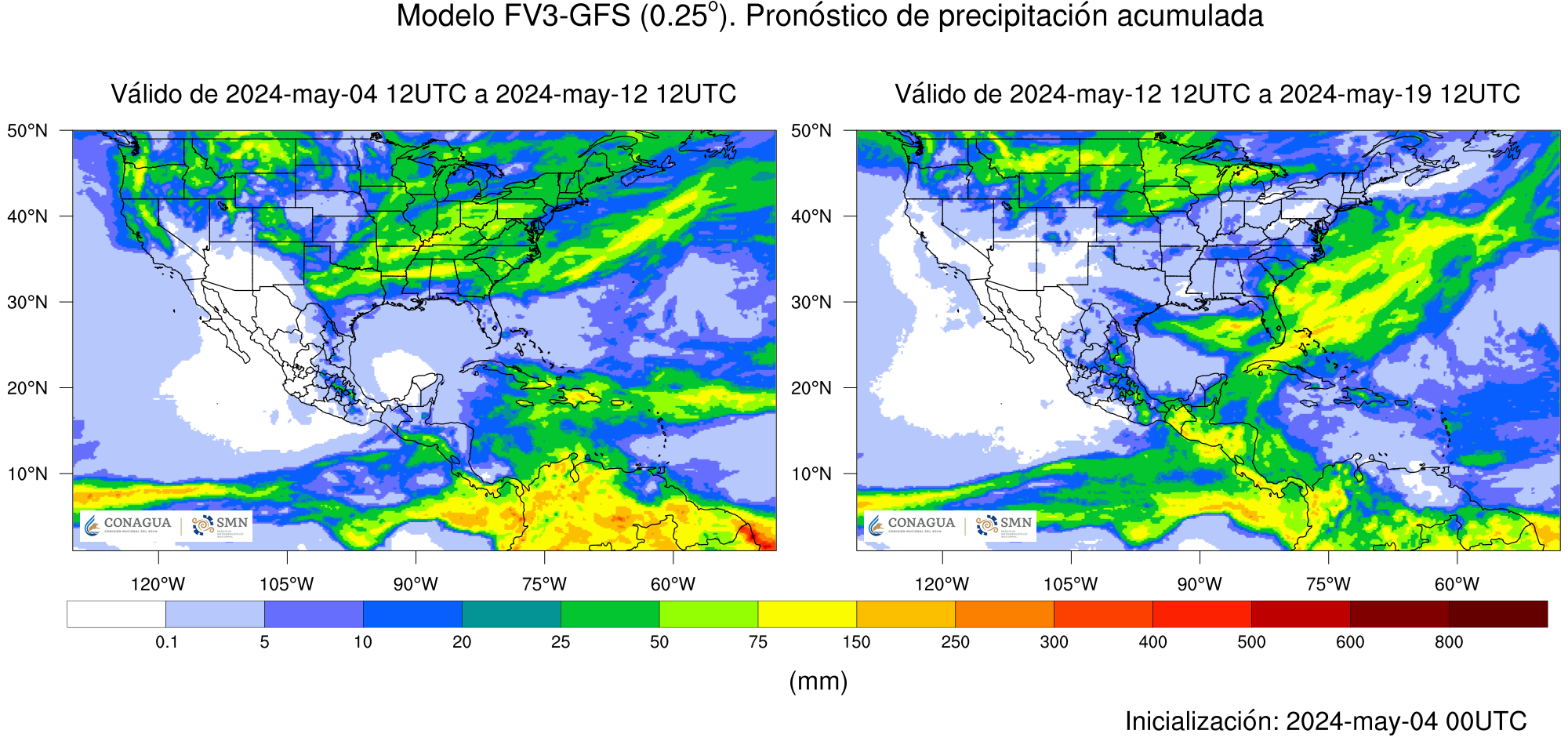
......looking forward to maybe some rain toward end of the week.

mtgoat666 - 9-4-2022 at 03:58 PM

This forecast is a bit early, so may be, may not be…


[Edited on 9-8-2022 by BajaNomad]

tiotomasbcs - 9-4-2022 at 04:01 PM

Hope you guys get rain from Javier & Kay but here in Todos Santos it would be nice to get a low grade TS or Cat 1 Hurricane! Javier dropped 2-4inches last week. Locals will never forget Odile and I was not here thankfully!
Love the rain and green scenery but the winds can be damaging--Odile!! Wish us LUCK down here..Salud!


[Edited on 9-4-2022 by tiotomasbcs]

mtgoat666 - 9-4-2022 at 04:04 PM


[Edited on 9-8-2022 by BajaNomad]

mtgoat666 - 9-4-2022 at 04:08 PM


[Edited on 9-8-2022 by BajaNomad]

shari - 9-4-2022 at 05:07 PM

sure not looking good for us here in Asuncion...enormous swell will test the new seawall for sure and looks like extremely high winds and lots of rain...dang it. It's a crap shoot if it will hit the tip and split into 2, or get sucked over to the gulf side's warm waters or go west...I will take any of those!

John Harper - 9-4-2022 at 05:27 PM

Found a heat index calculator, courtesy of NWS:
https://www.wpc.ncep.noaa.gov/html/heatindex.shtml

So, 102* in Carlsbad with 69% humidity (NWS) yields heat index of 150*

I heard it hit 102* in Avalon today as well. Hmmm.

102* in all these places? I smell a conspiracy! Is the government now in control of our state's ambient temperature? Is Newsome involved? If they control indoor thermostats, who knows what they really control?

Do JZ and DK know about this?

John

[Edited on 9-5-2022 by John Harper]

RFClark - 9-4-2022 at 05:36 PM

As I said we’re headed north Saturday. We’ll have our StarLink with us and post pictures and news as indicated. Currently most of the models have shifted west. Looks like landfall at Goats place in SD! A drought and a flood at the same time only in California.

Don Pisto - 9-4-2022 at 05:49 PM

Quote: Originally posted by John Harper  
Found a heat index calculator, courtesy of NWS:
https://www.wpc.ncep.noaa.gov/html/heatindex.shtml

So, 102* in Carlsbad with 69% humidity (NWS) yields heat index of 150*

I heard it hit 102* in Avalon today as well. Hmmm.

102* in all these places? I smell a conspiracy! Is the government now in control of our state's ambient temperature? Is Newsome involved? If they control indoor thermostats, who knows what they really control?

Do JZ and DK know about this?

John

[Edited on 9-5-2022 by John Harper]


something is definitely hinky here...this from wikipedia "102 (one hundred [and] two) is the natural number following 101 and preceding 103."......what do they take us for?

SFandH - 9-4-2022 at 05:52 PM

102 is also twice 51 - a prime number - very suspicious - I bet the FBI is in on it.

John Harper - 9-4-2022 at 05:52 PM

Quote: Originally posted by Don Pisto  
Quote: Originally posted by John Harper  
Found a heat index calculator, courtesy of NWS:
https://www.wpc.ncep.noaa.gov/html/heatindex.shtml

So, 102* in Carlsbad with 69% humidity (NWS) yields heat index of 150*

I heard it hit 102* in Avalon today as well. Hmmm.

102* in all these places? I smell a conspiracy! Is the government now in control of our state's ambient temperature? Is Newsome involved? If they control indoor thermostats, who knows what they really control?

Do JZ and DK know about this?

John


something is definitely hinky here...this from wikipedia "102 (one hundred [and] two) is the natural number following 101 and preceding 103."......what do they take us for?


OMG, you solved it!!!! The New World Order!!!!

John

SFandH - 9-4-2022 at 05:55 PM

Anyway, Goat hurricane predictions, I'm betting on the CEMN track.

mtgoat666 - 9-4-2022 at 09:02 PM

Quote: Originally posted by SFandH  
Anyway, Goat hurricane predictions, I'm betting on the CEMN track.


I don’t bet on tracks. I trust scientists to interpret computer outputs. Here is latest prediction:


[Edited on 9-8-2022 by BajaNomad]

Early Rainfall Forecast

RFClark - 9-4-2022 at 09:07 PM

If this is anyway near accurate driving to anywhere in Baja will be a problem for months!

On the bright side we can have a pool party Saturday at Goat’s place in SD even if he doesn’t have a pool! LA looks to get rain too!

8504F66A-C78C-4E4C-A90C-C7ADBFAC86DD.png - 299kB

[Edited on 9-5-2022 by RFClark]

mtgoat666 - 9-4-2022 at 09:20 PM

Quote: Originally posted by RFClark  
If this is anyway near accurate driving to anywhere in Baja will be a problem for months!

On the bright side we can have a pool party Saturday at Goat’s place in SD even if he doesn’t have a pool! LA looks to get rain too!


[Edited on 9-5-2022 by RFClark]


Clarkie,
It’s gonna be a big a$$ storm!

mtgoat666 - 9-5-2022 at 06:18 AM


[Edited on 9-5-2022 by mtgoat666]

mtgoat666 - 9-5-2022 at 07:21 AM


[Edited on 9-8-2022 by BajaNomad]

mtgoat666 - 9-5-2022 at 08:36 AM


Quantitative Precipitation Forecasts

https://www.wpc.ncep.noaa.gov/qpf/day1-7.shtml


[Edited on 9-5-2022 by mtgoat666]

monoloco - 9-5-2022 at 12:13 PM

Windy is predicting a rain accumulation of up to 1 meter in the central part of the peninsula. I wouldn't be planning any midweek trips.

What' up with the 2s?

AKgringo - 9-5-2022 at 02:22 PM

At 2:22 local time, it is 102 degrees for the 2nd day in a row (Grass Valley CA)

mtgoat666 - 9-5-2022 at 03:12 PM

BULLETIN
Hurricane Kay Advisory Number 6
NWS National Hurricane Center Miami FL EP122022
300 PM MDT Mon Sep 05 2022

...KAY STRENGTHENS INTO A HURRICANE...
...OUTER RAIN BANDS CONTINUE TO AFFECT SOUTHWESTERN MEXICO...


SUMMARY OF 300 PM MDT...2100 UTC...INFORMATION
----------------------------------------------
LOCATION...15.6N 107.3W
ABOUT 305 MI...495 KM SW OF MANZANILLO MEXICO
ABOUT 530 MI...855 KM SSE OF THE SOUTHERN TIP OF BAJA CALIFORNIA
MAXIMUM SUSTAINED WINDS...80 MPH...130 KM/H
PRESENT MOVEMENT...WNW OR 295 DEGREES AT 10 MPH...17 KM/H
MINIMUM CENTRAL PRESSURE...981 MB...28.97 INCHES


WATCHES AND WARNINGS
--------------------
CHANGES WITH THIS ADVISORY:

None.

SUMMARY OF WATCHES AND WARNINGS IN EFFECT:

A Tropical Storm Watch is in effect for...
* Loreto southward to Cabo San Lucas
* Cabo San Lucas northward to Puerto San Andresito

A Tropical Storm Watch means that tropical storm conditions are
possible within the watch area, generally within 48 hours.

Interests north of the watch area in Baja California should closely
monitor the progress of Kay as hurricane or tropical storm watches
could be required tonight or on Tuesday.

For storm information specific to your area, please monitor
products issued by your national meteorological service.


DISCUSSION AND OUTLOOK
----------------------
At 300 PM MDT (2100 UTC), the center of Hurricane Kay was
located near latitude 15.6 North, longitude 107.3 West. Kay is
moving toward the west near 12 mph (19 km/h). A turn to the
west-northwest is expected tonight, followed by a northwest to
north-northwest motion by late Tuesday. On the forecast track, the
center of Kay is expected to remain south and southwest of
southwestern Mexico through tonight, then move to the west of the
southern Baja California peninsula on Wednesday.

Maximum sustained winds have increased to near 80 mph (130 km/h)
with higher gusts. Continued strengthening is forecast through
midweek.

Hurricane-force winds extend outward up to 30 miles (45 km) from the
center and tropical-storm-force winds extend outward up to 175 miles
(280 km).

The minimum central pressure very recently reported by the Air
Force Hurricane Hunters is 981 mb (28.97 inches).


HAZARDS AFFECTING LAND
----------------------
Key messages for Hurricane Kay can be found in the Tropical
Cyclone Discussion under AWIPS header MIATCDEP2 and WMO header
WTPZ42 KNHC and on the web at hurricanes.gov/text/MIATCDEP2.shtml.

WIND: Tropical-storm-force wind gusts in outer rainbands are
likely near the coast of southwestern Mexico during the next day or
so. Tropical storm conditions are possible in the watch area in
the southern Baja California peninsula by early Wednesday.

SURF: Swells generated by Kay will affect portions of the coast of
southwestern Mexico during the next few days. Large swells are
likely to reach the southern portion of the Baja California
peninsula on Tuesday and are expected to spread up the peninsula
and the Gulf of California later this week. These swells will
likely cause life-threatening surf and rip current conditions.
Please consult products from your local weather office.

RAINFALL: Kay is expected to produce 3 to 6 inches of rainfall,
with isolated storm total amounts of 10 inches, across portions of
the Mexican Riviera and western Mexico through Wednesday night.
These rainfall amounts could lead to flash flooding, including
landslides.


NEXT ADVISORY
-------------
Next intermediate advisory at 600 PM MDT.
Next complete advisory at 900 PM MDT.

$$
Forecaster Cangialosi

bajaric - 9-5-2022 at 03:26 PM

Anyone want to guess where Kay will make landfall?
Accuweather Sept 5

Capture accuweather.PNG - 118kB

gnukid - 9-5-2022 at 03:58 PM

My guess

stormhit.PNG - 144kB

AKgringo - 9-5-2022 at 04:19 PM

My guess is that the eye will stay offshore, but the outer bands are still going to dump rain all over the peninsula!

SFandH - 9-5-2022 at 06:40 PM

Quote: Originally posted by AKgringo  
My guess is that the eye will stay offshore, but the outer bands are still going to dump rain all over the peninsula!


I'm guessing massive rainfall over the central mountains, resulting in water gushing through coastal towns on both sides. Gushing!

Ateo - 9-5-2022 at 08:37 PM

I’m hoping this hurricane does something for the sand bar at Scorpion Bay.

This storm is big. I was working in LA today and the car wash owners are watching the rain schedule for later this week.

My avocados and mango trees could use some free watering.

gnukid - 9-5-2022 at 09:00 PM

Maybe the waves down the beach will better where the estero river enters the ocean, what's it called down there San Gregorio?

https://www.instagram.com/p/CiGzJJDjxQT/

pacificobob - 9-5-2022 at 10:20 PM

Eebmike and windy are showing less wind and rain than earlier forcasts

mtgoat666 - 9-6-2022 at 06:09 AM

Forecasted hurricane track is indicating the high winds may stay off shore, but the QPF still shows massive amounts of rain for most of baja.
They are forecasting just a wee bit of rain for San Diego.

https://www.wpc.ncep.noaa.gov/qpf/day1-7.shtml


StuckSucks - 9-6-2022 at 08:41 AM

Hummm ... might have to go out storm chasing this Saturday in the SoCal high desert.

BajaRat - 9-6-2022 at 09:11 AM

Quote: Originally posted by tiotomasbcs  
Hope you guys get rain from Javier & Kay but here in Todos Santos it would be nice to get a low grade TS or Cat 1 Hurricane! Javier dropped 2-4inches last week. Locals will never forget Odile and I was not here thankfully!
Love the rain and green scenery but the winds can be damaging--Odile!! Wish us LUCK down here..Salud!


[Edited on 9-4-2022 by tiotomasbcs]


The Fam will be thinking about you Tio
Hang in there
Lionel :cool:

BajaRat - 9-6-2022 at 09:27 AM

Possibility of some rare SOC epic surf spots coming to life
Lionel :cool:

azucena - 9-6-2022 at 11:51 AM

Just saw a video on FB. Kay is rolling into Loreto.

David K - 9-6-2022 at 12:16 PM

Seeing streets turned into rivers in Mulegé and Santa Rosalia on FB videos from the past two days. Pre-Kay storm fronts, maybe? I would expect this to be a wet storm with the typical roads being washed out at vados, etc. This may be an issue as far north as San Felipe +, so be prepared to not get supplies or to travel for at least two days after the floods happen. San Diego is now predicting 1/2 inch to fall on Saturday morning.

David K - 9-6-2022 at 12:22 PM

San Javier Road video here: https://www.instagram.com/guia_loretobcs/

also: https://www.facebook.com/groups/mulegenewsfeed

[Edited on 9-6-2022 by David K]

gnukid - 9-6-2022 at 12:30 PM


Entrance to La Ventana

305487769_10218287590096251_7634181507054508364_n.jpeg - 40kB

Agua Amarga

WhatsApp Image 2022-09-06 at 1.01.59 PM.jpeg - 193kB

Hills next to Muertos

WhatsApp Image 2022-09-06 at 1.02.01 PM.jpeg - 137kB

Muertos


WhatsApp Image 2022-09-02 at 1.38.53 PM.jpeg - 108kB

Hook - 9-6-2022 at 12:46 PM

Quote: Originally posted by David K  
Seeing streets turned into rivers in Mulegé and Santa Rosalia on FB videos from the past two days. Pre-Kay storm fronts, maybe?


It seems not. There have been large, convective storms forming around the mountains of Sinaloa for the past 2-3 days. Kinda rare, actually, for it to form there and then head NW from there and make it out over the gulf. There, they have largely been dissipating.

But NOW, the outer bands of Kay are making their way into the Baja precipitation discussion. Kay's moisture is being felt all along Baja and into northern Sinaloa and most of Sonora.

San Carlos Sonora has only received about a half inch (from the Sinaloa disturbance) in the last 18 hours. But possibly 2-4 inches could happen between Wed evening and Thur evening.

I still think orographics on the higher elevations Peninsula could still produce 8-12 inches in 48 hours (Wed to Fri) I would not trust downgraded estimates just yet.

Hook - 9-6-2022 at 12:51 PM

Accuweather's latest rainfall prediction overlay seems to have bumped the potential rain in Central Baja up to the 8-16 inch bracket. :o


[Edited on 9-6-2022 by Hook]

mtgoat666 - 9-6-2022 at 12:51 PM

BULLETIN
Hurricane Kay Intermediate Advisory Number 9A
NWS National Hurricane Center Miami FL EP122022
1200 PM MDT Tue Sep 06 2022

...KAY PRODUCING ROUGH SURF ACROSS SOUTHWESTERN MEXICO AND SOUTHERN
BAJA CALIFORNIA PENINSULA...
...AIR FORCE HURRICANE HUNTERS ENROUTE...


SUMMARY OF 1200 PM MDT...1800 UTC...INFORMATION
-----------------------------------------------
LOCATION...18.4N 110.5W
ABOUT 320 MI...515 KM SSW OF THE SOUTHERN TIP OF BAJA CALIFORNIA
MAXIMUM SUSTAINED WINDS...85 MPH...140 KM/H
PRESENT MOVEMENT...NW OR 315 DEGREES AT 14 MPH...22 KM/H
MINIMUM CENTRAL PRESSURE...977 MB...28.85 INCHES


WATCHES AND WARNINGS
--------------------
CHANGES WITH THIS ADVISORY:

None.

SUMMARY OF WATCHES AND WARNINGS IN EFFECT:

A Tropical Storm Warning is in effect for...
* San Evaristo southward to Cabo San Lucas
* Cabo San Lucas northward to Cabo San Lazaro

A Tropical Storm Watch is in effect for...
* North of San Evaristo northward to Santa Rosalia
* North of Cabo San Lazaro northward to Punta Abreojos

A Tropical Storm Warning means that tropical storm conditions are
expected somewhere within the warning area within 36 hours.

A Tropical Storm Watch means that tropical storm conditions are
possible within the watch area, generally within 48 hours.

Interests north of the watch area on the Baja California peninsula
should closely monitor the progress of Kay as hurricane or tropical
storm watches could be required later today.

For storm information specific to your area, please monitor
products issued by your national meteorological service.


DISCUSSION AND OUTLOOK
----------------------
At 1200 PM MDT (1800 UTC), the center of Hurricane Kay was located
near latitude 18.4 North, longitude 110.5 West. Kay is moving toward
the northwest near 14 mph (22 km/h) and this general motion should
continue through tonight. A turn toward the north-northwest is
expected on Wednesday, and this motion should continue into Friday.
On the forecast track, the center of Kay is expected to pass to the
west of the southern Baja California peninsula on Wednesday, and be
near the west-central coast of the Baja California peninsula
Thursday and Friday.

Maximum sustained winds remain near 85 mph (140 km/h) with higher
gusts. Strengthening is forecast during the next 36 hours, and Kay
could become a major hurricane during that time. Weakening is
forecast to begin by Thursday, but Kay is forecast to remain a
strong hurricane when it passes near the Baja California peninsula.

Hurricane-force winds extend outward up to 30 miles (45 km) from
the center and tropical-storm-force winds extend outward up to 175
miles (280 km). A weather station in Socorro Island recently
reported a wind gust of 47 mph (76 km/h).

The estimated minimum central pressure is 977 mb (28.85 inches).


HAZARDS AFFECTING LAND
----------------------
Key messages for Hurricane Kay can be found in the Tropical
Cyclone Discussion under AWIPS header MIATCDEP2 and WMO header
WTPZ42 KNHC and on the web at hurricanes.gov/text/MIATCDEP2.shtml.

WIND: Tropical storm conditions are expected within the warning
area in the southern Baja California peninsula beginning Wednesday
morning. Tropical storm conditions are possible in the watch area
in the southern Baja California peninsula by late Wednesday.

SURF: Swells generated by Kay will continue to affect portions of
the coast of southwestern Mexico during the next couple of days.
Large swells are expected to spread northward along the Baja
California coast and into the Gulf of California during the next
few days. These swells will likely cause life-threatening surf and
rip current conditions. Please consult products from your local
weather office.

RAINFALL: Kay is expected to produce 4 to 8 inches of rainfall,
with isolated storm total amounts of 12 inches, across portions of
western Mexico, including the Baja California peninsula, through
Thursday night. These rainfall amounts could lead to flash
flooding, including landslides.


NEXT ADVISORY
-------------
Next complete advisory at 300 PM MDT.

$$
Forecaster Cangialosi

mtgoat666 - 9-6-2022 at 12:58 PM


[Edited on 9-7-2022 by BajaNomad]

Rancho Nuevo looking SE towards Kay

RFClark - 9-6-2022 at 02:26 PM

15:20

.24” rain, light rain falling. Wind from the North 2mph.

092C608C-F898-41B3-9B2E-4D00186291E3.jpeg - 290kB

mtgoat666 - 9-6-2022 at 07:08 PM


Latest forecast has central baja being hit with 6 to 8 inches of rain, with some areas at 12 inches rain.


[Edited on 9-7-2022 by mtgoat666]

[Edited on 9-7-2022 by BajaNomad]

Bajazly - 9-6-2022 at 07:44 PM

Please send some rain to San Felipe, no real rain here in a year ish or better. At lease not a few miles out of town.

lewmt - 9-7-2022 at 05:32 AM

https://magicseaweed.com/Punta-Abreojos-Surf-Report/1250/

This much surf can't be good for the Pac side

John Harper - 9-7-2022 at 08:16 AM

Quote: Originally posted by lewmt  
https://magicseaweed.com/Punta-Abreojos-Surf-Report/1250/

This much surf can't be good for the Pac side


14-22' on Thursday??? Holy cowabunga!!!

John

RFClark - 9-7-2022 at 08:25 AM

Centos Beach South: Currently the wind is from the east to south in the 7 - 16 mph range .13 inches of rain since midnight.

David K - 9-7-2022 at 09:36 AM

Today's San Diego morning news revised local rain. Now forecasted to begin on Friday and last through Saturday, but only with a total of 1/10 inch of rainfall.

Hurricane looks like Cat. 2 off of Shari's place and to be Cat. 1 as far north as offshore from El Rosario then tropical storm to about the Ensenada latitude where it then turns and goes further out to sea.

Rancho Nuevo BCS 11:30

RFClark - 9-7-2022 at 10:45 AM

Wind S/SE 15 - 20 mph Gusts to 30 mph Rain .55”

2B9A4ECF-44C5-4392-9B02-D24B982CF693.jpeg - 171kB

mtgoat666 - 9-7-2022 at 11:42 AM

Quote: Originally posted by David K  
Today's San Diego morning news revised local rain. Now forecasted to begin on Friday and last through Saturday, but only with a total of 1/10 inch of rainfall.

Hurricane looks like Cat. 2 off of Shari's place and to be Cat. 1 as far north as offshore from El Rosario then tropical storm to about the Ensenada latitude where it then turns and goes further out to sea.


were you watching chrissy russo on fox?
latest from NWS (big govt brains!) still shows san diego getting 1/2 inch to over 1 inch, and laguna mountains getting walloped.
All of baja from loreto up to ensenada is going to be drenched and everyones hair will be wind-swept


[Edited on 9-7-2022 by mtgoat666]

[Edited on 9-7-2022 by mtgoat666]

David K - 9-7-2022 at 11:48 AM

No, Mark Mathis, on KUSI.

[Edited on 9-7-2022 by David K]

David K - 9-7-2022 at 11:54 AM

City/coastal SD County, not the Laguna mountains. Like any forecast, it is an prediction and not a fact... Much like global warming and sea level rise. Only better, because we are talking 2-3 days away, not 12-20 years.

BajaGringo - 9-7-2022 at 12:17 PM

I have been following and reporting on tropical storms in the Eastern Pacific for a couple of decades now and don't recall ever seeing the coastline surrounding the entire peninsula under a tropical storm alert status:


175744_5day_cone_no_line_and_wind.png - 76kB

SFandH - 9-7-2022 at 12:32 PM

Quote: Originally posted by BajaGringo  
I have been following and reporting on tropical storms in the Eastern Pacific for a couple of decades now and don't recall ever seeing the coastline surrounding the entire peninsula under a tropical storm alert status:


Warm ocean. It's 74 today off of La Jolla San Diego, maybe 5 degrees higher than normal for this time of year.

gnukid - 9-7-2022 at 12:44 PM

Quote: Originally posted by BajaGringo  
I have been following and reporting on tropical storms in the Eastern Pacific for a couple of decades now and don't recall ever seeing the coastline surrounding the entire peninsula under a tropical storm alert status:


List of Baja California Peninsula hurricanes
https://en.wikipedia.org/wiki/List_of_Baja_California_Penins...

BajaGringo - 9-7-2022 at 02:02 PM

Quote: Originally posted by gnukid  
Quote: Originally posted by BajaGringo  
I have been following and reporting on tropical storms in the Eastern Pacific for a couple of decades now and don't recall ever seeing the coastline surrounding the entire peninsula under a tropical storm alert status:


List of Baja California Peninsula hurricanes
https://en.wikipedia.org/wiki/List_of_Baja_California_Penins...


Yes, I am quite well aware and keep my own archives.

My point was, it's worth noting that the entire coastline perimeter of the Baja Peninsula is under a tropical storm alert (watch/warning) at the same point in time. I can find nothing like that in 20 years of my weather / storm forecast archives.

mtgoat666 - 9-7-2022 at 02:13 PM

Quote: Originally posted by BajaGringo  
Quote: Originally posted by gnukid  
Quote: Originally posted by BajaGringo  
I have been following and reporting on tropical storms in the Eastern Pacific for a couple of decades now and don't recall ever seeing the coastline surrounding the entire peninsula under a tropical storm alert status:


List of Baja California Peninsula hurricanes
https://en.wikipedia.org/wiki/List_of_Baja_California_Penins...


Yes, I am quite well aware and keep my own archives.

My point was, it's worth noting that the entire coastline perimeter of the Baja Peninsula is under a tropical storm alert (watch/warning) at the same point in time. I can find nothing like that in 20 years of my weather / storm forecast archives.


the storm will be a whopper for the penninsula...

here is latest san diego rain forecast for DK:


[Edited on 9-8-2022 by BajaNomad]

mtgoat666 - 9-7-2022 at 02:16 PM


SFandH - 9-7-2022 at 03:59 PM

Yeah, this is the hurricane Kay thread. Let's keep it that way.

John Harper - 9-7-2022 at 04:06 PM

I notice some of the maps are in Zulu time, so adjust accordingly.

John


[Edited on 9-7-2022 by John Harper]

SFandH - 9-7-2022 at 04:37 PM

Just spoke to a friend in Todos Santos, he said it's blowin' hard, maybe a cat 1.


[Edited on 9-7-2022 by SFandH]

RFClark - 9-7-2022 at 04:45 PM

SF&H,

We just returned to Todos Santos. Wind in Rancho Nuevo 16mph, wind in TS 9mph no rain just a few drops. The glass started to rise a few minutes ago. Seas are rough!

E37C22AE-29C0-4D35-92BA-CC077118E91D.png - 92kB

SFandH - 9-7-2022 at 04:47 PM

Quote: Originally posted by RFClark  
SF&H,

We just returned to Todos Santos. Wind in Rancho Nuevo 16mph, wind in TS 9mph no rain just a few drops. The glass started to rise a few minutes ago. Seas are rough!


Well, give my buddy a call and set him straight.

Where's Rancho Nuevo?


[Edited on 9-7-2022 by SFandH]

RFClark - 9-7-2022 at 04:52 PM

Rancho Nuevo is south of Cerritos Beach at KM 72 on the road to Cabo. Highest gusts today have been about 45mph. We drove down to check on the house. Really big waves at Cerritos Beach.

pacificobob - 9-7-2022 at 05:28 PM

Rancho nuevo is a community of gringos living behind a gate south of el pescadero.

Bajazly - 9-7-2022 at 07:01 PM

Getting cloudy from the east and big cloud bank to the south with a brisk south wind blowing all day up here in SF. Hoping for rain. WU says a little over 4" from tomorrow thru Saturday AM... We will see I guess.

mtgoat666 - 9-7-2022 at 08:29 PM

Hey boomers! Stop talking trash! Look at this:


[Edited on 9-8-2022 by mtgoat666]

[Edited on 9-8-2022 by BajaNomad]

JZ - 9-7-2022 at 09:10 PM

Quote: Originally posted by mtgoat666  
Hey boomers! Stop talking trash! Look at this:


15 years on the board and you still don't know how to post a pic? How is anyone supposed to take anything you say seriously?


[Edited on 9-8-2022 by JZ]

RFClark - 9-7-2022 at 09:59 PM

Goat,

In other news, the rainfall from Hurricane Kay was from 1/2 -3/4 inches in Todos Santos today. The wind is down to around 20mph. I pray that the people north of here come through this as well as we have.

A quick check of the few weather stations in BCS La Paz .44” today, Scorpion Bay .13”, Muligé .44” today, Bahía Asunción .02” also today.

[Edited on 9-8-2022 by RFClark]

[Edited on 9-8-2022 by RFClark]

Ateo - 9-7-2022 at 10:18 PM

Shari and other's in the path towards GN, take caution tomorrow, and we'll see you on the other side of this thing!

Hook - 9-8-2022 at 04:40 AM

The latest satellite images seem to show Kay is moving more NNE, rather than the predicted NNW track. Most of the clouds on radar appears to be slamming into Baja right now.

Bob and Susan - 9-8-2022 at 04:49 AM

on the bay the wind and rain blew all night

ave 30mph
gusts 50mph
4 inches of water already

its howling right now

looks like a bad day

SFandH - 9-8-2022 at 06:06 AM

Thanks for the info.

Looks like both coasts of mid-Baja are getting hit.


[Edited on 9-8-2022 by SFandH]

watizname - 9-8-2022 at 06:38 AM

Quote: Originally posted by Bob and Susan  
on the bay the wind and rain blew all night

ave 30mph
gusts 50mph
4 inches of water already

its howling right now

looks like a bad day


Ahhhhh. At last something useful. A real time report, with no political crap. Thanks Bob and Susan.

LaTijereta - 9-8-2022 at 07:22 AM

Heavy rain is back on in Loreto, along big wind/ gusts..

David K - 9-8-2022 at 07:23 AM

This morning's San Diego news (KUSI) has revised the hurricane's track to be closer to the coast off San Diego than yesterday's guess. Now predicting 1"-1.5" rain along the coast and .5"-1" inland valleys with strong winds.

If the hurricane crosses over Baja to the gulf (as one track estimate shows), the water temps there will recharge the hurricane and be a 'bad thing' for San Felipe to Yuma AZ.

JZ - 9-8-2022 at 07:26 AM

My friends in San Carlos, Sonora say it's been raining for a month now. They aren't happy about the hurricane and more raining and flooding.

lewmt - 9-8-2022 at 07:28 AM

It's interesting that this storm isn't falling apart as it hits land. It seems like most Hurricanes don't sustain intensity very well once they have made landfall.

Sent messages to a friend in P. Abreojos & La Bocana. Got replies which was good and they are reporting a lot of rain and wind but hadn't done any tremendous damage ..... yet.

Rancho Nuevo current

RFClark - 9-8-2022 at 07:29 AM

Wind 9.2mph SSW rain 0 storm total .66”

E8BADF19-EEE5-4ACB-A426-737D5AD4AF03.jpeg - 179kB

David K - 9-8-2022 at 07:40 AM

It is over the Pacific, paralleling the peninsula... the eye hasn't made landfall, I don't think? Anyone want to post the sat map for today?

SFandH - 9-8-2022 at 07:50 AM

Just watched a new FB video taken this morning from the Highway 1 bridge over the Mulege River. Major flooding. It's a torrent of muddy water well over the normal river banks. Not good for the downriver riverside homes.

Hook - 9-8-2022 at 07:55 AM

It's really tough to beat eebmike.com for concise, up-to-the-minute images and text, when it comes to disturbances along the west coast of Mexico. One click, and you get aggregated imaging from several sources and the NHC or NOAA discussion.

Why post the images? One click and you have everything except real time rainfall totals and wind speeds.

It keeps the potential for screwing up a thread's format to a minimum, a la Goat.

Hook - 9-8-2022 at 07:58 AM

Sure seems like Abreojos and surroundings might get to experience The Eye!!

Hook - 9-8-2022 at 08:02 AM

Quote: Originally posted by SFandH  
Just watched a new FB video taken this morning from the Highway 1 bridge over the Mulege River. Major flooding. It's a torrent of muddy water well over the normal river banks. Not good for the downriver riverside homes.


How about those videos from the Oasis along the river?

https://www.facebook.com/groups/mulegenewsfeed/

SFandH - 9-8-2022 at 08:13 AM

Thanks, I don't know why I didn't think of posting the links. Perhaps another cup of coffee is needed.

This is part of El Oasis on the Mulege River. The entire area is now flooded. I don't know how high the water is.


el oasis.png - 265kB

[Edited on 9-8-2022 by SFandH]

San Felipe Current

RFClark - 9-8-2022 at 08:20 AM

Wind 5.4mph NNW rain 0 Light rain south at Gonzaga bay

97A1FC6C-EE72-4CC3-8AC6-301069429CFB.jpeg - 126kB

A3605707-5AFA-43F5-92BD-CC74FC39786E.jpeg - 311kB

[Edited on 9-8-2022 by RFClark]

[Edited on 9-8-2022 by RFClark]

F6185736-53F1-4C43-9EBB-BAE7E3F9F8C8.jpeg - 292kB

Bajazly - 9-8-2022 at 08:38 AM

Overcast here in SF but not drop of rain.

EngineerMike - 9-8-2022 at 08:46 AM

Thanks Bob & Sharon for the real time posts. Today will be Mulege & Santa Rosalia's day for Kay, all the rain in the mountains up to the divide flow thru these two towns.


[Edited on 9-8-2022 by EngineerMike]

David K - 9-8-2022 at 08:55 AM

Quote: Originally posted by Hook  
Quote: Originally posted by SFandH  
Just watched a new FB video taken this morning from the Highway 1 bridge over the Mulege River. Major flooding. It's a torrent of muddy water well over the normal river banks. Not good for the downriver riverside homes.


How about those videos from the Oasis along the river?

https://www.facebook.com/groups/mulegenewsfeed/


Thanks Hook... I also have been sharing the flooding videos on my VivaBaja group (La Bocana, Bahía Asunción, Mulegé, etc.). https://www.facebook.com/groups/vivabaja

Nomad 'steekers' went to Gonzaga Bay and posted photos from yesterday and this morning on the Friends of Gonzaga Bay page: https://www.facebook.com/groups/480665265646984

Here is the Gonzaga webcam at Papa Fernandez' looking south, showing the clouds coming in. http://www.papafernandez.com/photos/latest.mp4?1653510909

SFandH - 9-8-2022 at 10:36 AM

More Mulege River

https://www.facebook.com/watch?v=475318454463129

EngineerMike - 9-8-2022 at 10:40 AM

Getting real time info from Mulege:
1. High tide is 9am, low is 3pm (Mulege gorge is subject to tide so floods are tide-time dependent for high water)
2. At big bridge the water level lacks ~3-4M from bottom of bridge concrete, buildings still visible in La Fortuna & Yee's trailer park
3. Extreme upper end of Oasis maybe 4-5 feet coming out of the Orchard, decreasing heading east to the Cortez, probably 3ft at the Oasis Office. Water moving slowly (relatively), very muddy look to it but won't be thick heavy mud due to low-ish velocity.
4. heading into low tide at 3pm will temper any increases in drainage as may occur from the high mountains from heavy cells
Not a Biblical disaster for Mulege so far, there will be a lot of trouble for locals however who didn't have resources to lay in food, etc. I'm guessing Baja Bush Pilots are revving up as there will be plenty of road outages and stranded folk.

 Pages:  1